Green Branch (Patuxent River)

Last updated

The Green Branch of the Patuxent River in Prince George's County, Maryland is part of the Upper Patuxent Watershead. [1] The stream passes centrally through the Governor Bridge Natural Area / Patuxent River Park [2] and joins the Patuxent, just south of Governor's Bridge.

Patuxent River river in the state of Maryland, United States

The Patuxent River is a tributary of the Chesapeake Bay in the state of Maryland. There are three main river drainages for central Maryland: the Potomac River to the west passing through Washington, D.C., the Patapsco River to the northeast passing through Baltimore, and the Patuxent River between the two. The 908-square-mile (2,352 km2) Patuxent watershed had a rapidly growing population of 590,769 in 2000. It is the largest and longest river entirely within Maryland, and its watershed is the largest completely within the state.

Prince Georges County, Maryland County in the United States

Prince George's County is located in the U.S. state of Maryland, bordering the eastern portion of Washington, D.C. As of the 2010 U.S. Census, the population was 863,420, making it the second-most populous county in Maryland, behind Montgomery County. Its county seat is Upper Marlboro. It is one of the richest African American-majority counties in the United States, with five of its communities identified in a 2015 top ten list.

Governors Bridge (Patuxent River) bridge in United States of America

Governor's Bridge is an historic single-lane bridge over the Patuxent River near Bowie, Maryland. The river marks the boundary between Prince George's and Anne Arundel counties. A bridge has been located on this site since the mid-18th century.

Contents

The stream cuts a narrow gorge through the Aquia greensand between Crain Highway and its junction with the Patuxent. [3]

The Aquia Formation is a geologic sandstone formation that extends from the upper Chesapeake Bay to the James River near Hopewell, Virginia. It consists of clayey, silty, very shelly, glauconitic sand. Fossil records indicate that this stratigraphic unit was created during the Paleocene.

Drainage area

Green Branch drains the communities of Heather Hills, Ensleigh, Essington, Easthaven, Heather Ridge, Palisades, Pin Oak Village, Covington Manor, Governors Green and Longlea as well as the commercial areas of Bowie Gateway Center and Prince George's Stadium within Bowie, Maryland. [4]

Prince Georges Stadium sports venue in Bowie, Maryland, United States; primarily used for baseball

Prince George's Stadium is a multipurpose sports venue located in unincorporated Prince George's County, Maryland, near Bowie, primarily used for baseball. It is home of the Baltimore Orioles' Double-A affiliate in the Eastern League, the Bowie Baysox. The stadium is the result of a cooperative venture between Maryland Baseball Limited Partnership and the Maryland-National Capital Park and Planning Commission, and is built on park property.

Bowie, Maryland City in Maryland, United States

Bowie is a city in Prince George's County, Maryland, United States. The population was 54,727 at the 2010 U.S. Census. Bowie has grown from a small railroad stop to the largest municipality in Prince George's County, and the fifth most populous city and third largest city by area in the U.S. state of Maryland. In 2014 CNN Money ranked Bowie 28th in its Best Places to Live in America list.

Environmental concerns

The major pollutant in this stream is non-point sediment. [4] The source of the sediment is erosion from construction, storm water runoff carrying lawn chemicals such as excess fertilizer, and pet waste runoff from lawns. [4] Increased amount of runoff causes water to flow at a faster rate, which erodes stream banks and increases sediment in the water. [4]

Point source pollution

A point source of pollution is a single identifiable source of air, water, thermal, noise or light pollution. A point source has negligible extent, distinguishing it from other pollution source geometries. The sources are called point sources because in mathematical modeling, they can be approximated as a mathematical point to simplify analysis. Pollution point sources are identical to other physics, engineering, optics, and chemistry point sources and include:

A large culvert on Green Branch, was significantly impairing fish passage to spawning grounds upstream on the Patuxent in 2008. Fish including herring, alewife, and American eel could not pass through the three-pipe culvert located under an access road within the Governor Bridge Natural Area. The Patuxent Riverkeeper has been working with the Maryland Department of Natural Resources Fish Passage Program to fix this and has received funding from Fish America Foundation and Chesapeake Bay Trust to support the project. [5]

Herring forage fish, mostly belonging to the family Clupeidae

Herring are forage fish, mostly belonging to the family Clupeidae.

Alewife species of shad

The alewife is an anadromous species of herring found in North America. It is one of the "typical" North American shads, attributed to the subgenus Pomolobus of the genus Alosa. As an adult it is a marine species found in the northern West Atlantic Ocean, moving into estuaries before swimming upstream to breed in freshwater habitats, but some populations live entirely in fresh water. It is best known for its invasion of the Great Lakes by using the Welland Canal to bypass Niagara Falls. Here, its population surged, peaking between the 1950s and 1980s to the detriment of many native species of fish. In an effort to control them biologically, Pacific salmon were introduced, only partially successfully. As a marine fish, the alewife is a US National Marine Fisheries Service "Species of Concern".

American eel species of fish

The American eel is a facultative catadromous fish found on the eastern coast of North America. Eels are fish belonging to the elopomorph superorder, a group of phylogenetically ancient teleosts. The American eel has a slender, snake-like body that is covered with a mucus layer, which makes the eel appear to be naked and slimy despite the presence of minute scales. A long dorsal fin runs from the middle of the back and is continuous with a similar ventral fin. Pelvic fins are absent, and relatively small pectoral fins can be found near the midline, followed by the head and gill covers. Variations exist in coloration, from olive green, brown shading to greenish-yellow and light gray or white on the belly. Eels from clear water are often lighter than those from dark, tannic acid streams.

Related Research Articles

Anacostia River tributary of the Potomac River in Maryland and Washington, D.C.

The Anacostia River is a river in the Mid Atlantic region of the United States. It flows from Prince George's County in Maryland into Washington, D.C., where it joins with the Washington Channel to empty into the Potomac River at Buzzard Point. It is approximately 8.7 miles (14.0 km) long. The name "Anacostia" derives from the area's early history as Nacotchtank, a settlement of Necostan or Anacostan Native Americans on the banks of the Anacostia River.

Petitcodiac River A river in south-eastern New Brunswick, Canada

The Petitcodiac River, known informally as the Chocolate River, is a river in south-eastern New Brunswick, Canada. The river has a meander length of 79 kilometres and is located in Westmorland, Albert, and Kings counties, draining a watershed area of about 2,071 square kilometres (800 sq mi). The watershed features valleys, ridges, and rolling hills, and is home to a diverse population of terrestrial and aquatic species. Ten named tributaries join the river in its course toward its mouth in Shepody Bay. Before the construction of a causeway in 1968, the river had one of the world's largest tidal bores, which ranged from 1 to 2 metres (3.3–6.6 ft) in height and moved at 5 to 13 kilometres per hour (3.1–8.1 mph). With the opening of the causeway gates in April 2010, the river is flushing itself of ocean silts, and the Bore is returning to its former glory.

Patapsco River river in Maryland, United States

The Patapsco River mainstem is a 39-mile-long (63 km) river in central Maryland which flows into the Chesapeake Bay. The river's tidal portion forms the harbor for the city of Baltimore. With its South Branch, the Patapsco forms the northern border of Howard County, Maryland. The name "Patapsco" is derived from the Algonquian pota-psk-ut, which translates to "backwater" or "tide covered with froth."

Monocacy River river in Maryland, United States

The Monocacy River is a free-flowing left tributary to the Potomac River, which empties into the Atlantic Ocean via the Chesapeake Bay. The river is 58.5 miles (94.1 km) long, with a drainage area of about 744 square miles (1,930 km2). It is the largest Maryland tributary to the Potomac.

Severn River (Maryland) river in Maryland, United States

The Severn River is a tidal estuary 14 miles (23 km) long, located in Anne Arundel County in the U.S. state of Maryland, south of the Magothy River and north of the South River.

Antietam Creek creek in Pennsylvania and Maryland, United States

Antietam Creek is a 41.7-mile-long (67.1 km) tributary of the Potomac River located in south central Pennsylvania and western Maryland in the United States, a region known as the Hagerstown Valley. The creek became famous as a focal point of the Battle of Antietam during the American Civil War.

Low-water crossing bridge when the water flow is low

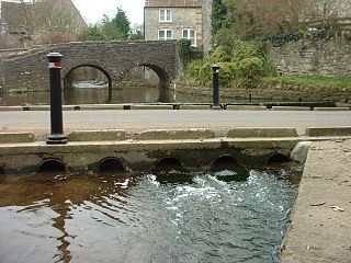
A low-water crossing provides a bridge when water flow is low. Under high-flow conditions, water runs over the roadway and precludes vehicular traffic. This approach is cheaper than building a bridge to raise the level of the road above the highest flood stage of a river, particularly in developing countries or in semi-arid areas with rare high-volume rain. Low-water crossings can be dangerous when flooded.

The South River is a 10-mile-long (16 km) tributary of the Chesapeake Bay in Anne Arundel County, Maryland in the United States. It lies south of the Severn River, east of the Patuxent River, and north of the West River and Rhode River, and drains to the Chesapeake Bay.

Cabin John Creek tributary stream of the Potomac River in Montgomery County, Maryland, USA

Cabin John Creek is a tributary stream of the Potomac River in Montgomery County, Maryland. The watershed covers an area of 26 square miles (67 km2). The headwaters of the creek originate in the city of Rockville, and the creek flows southward for 10.9 miles (17.5 km) to the Potomac River.

Collington, Maryland defunct settlement in Maryland

Collington, Maryland is a now defunct settlement in Prince George's County, Maryland dating from colonial times. Collington has been subsumed by the city of Bowie, Maryland.

Paint Branch one of two headwaters of the Northeast Branch Anacostia River in Montgomery and Prince George’s counties, Maryland, U.S.

Paint Branch is a 14.0-mile-long (22.5 km) stream that flows through Montgomery County and Prince George's County, Maryland. It is a tributary of the Northeast Branch, which flows to the Anacostia River, Potomac River and the Chesapeake Bay.

Watts Branch (Potomac River tributary) tributary stream of the Potomac River in Montgomery County, Maryland, United States

Watts Branch is a tributary stream of the Potomac River in Montgomery County, Maryland.

Watts Branch (Anacostia River tributary)

Watts Branch is a tributary stream of the Anacostia River in Prince George's County, Maryland, and Washington, D.C.

Hickey Run is a tributary stream of the Anacostia River in Washington, D.C..

Double Pipe Creek tributary of the Monocacy River in Maryland

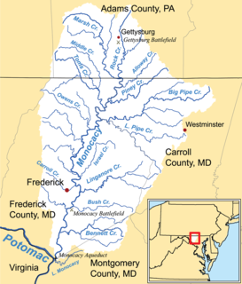
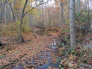
Double Pipe Creek, sometimes called Pipe Creek, is a major tributary of the Monocacy River in Carroll County and Frederick County in Maryland, located several miles north and west of Westminster. The creek is only 1.6 miles (2.6 km) long, but is formed by the confluence of two much longer streams, Big Pipe Creek and Little Pipe Creek.

Mahantango Creek is a 2.1-mile-long (3.4 km) tributary of the Susquehanna River in Snyder and Juniata counties, Pennsylvania, in the United States. Its name comes from a Delaware Indian word meaning "where we had plenty to eat". The creek flows along the border between Snyder County and Juniata County.

Collington Branch is a stream that flows into the Western Branch of the Patuxent River in Prince George's County, Maryland.

Mill Branch of the Patuxent River in Prince George's County, Maryland is part of the Upper Patuxent Watershead.

References

  1. "City of Bowie Environmental Infrastructure Action Strategy Plan Staff Findings and Recommendations By Sub-watershed". City of Bowie. p. ii. Retrieved 2 January 2014.
  2. "Governor Bridge Natural Area / Patuxent River Park Trail Map" (PDF). Maryland-National Capital Park and Planning Commission . Retrieved 2 January 2014.
  3. Geology and Water Resources of Prince George's County: Bulletin, Issue 10. Baltimore, Maryland: Maryland Geological Survey. 1952. p. 29.
  4. 1 2 3 4 "City of Bowie Environmental Infrastructure Action Strategy Plan Staff Findings and Recommendations By Sub-watershed". City of Bowie. p. 26. Retrieved 2 January 2014.
  5. "Green Branch Fish Passage Project" (PDF). Patuxent Riverkeeper Newsletter. Patuxent Riverkeeper. p. 5. Retrieved 2 January 2014.

See also

Coordinates: 38°56′46.6″N76°42′29.5″W / 38.946278°N 76.708194°W / 38.946278; -76.708194

Geographic coordinate system Coordinate system

A geographic coordinate system is a coordinate system that enables every location on Earth to be specified by a set of numbers, letters or symbols. The coordinates are often chosen such that one of the numbers represents a vertical position and two or three of the numbers represent a horizontal position; alternatively, a geographic position may be expressed in a combined three-dimensional Cartesian vector. A common choice of coordinates is latitude, longitude and elevation. To specify a location on a plane requires a map projection.