History
The area was estate countryside in the 19th century, characterized by large homes built by prominent city residents on the hilly countryside several hundred feet above the Inner Harbor area. Mondawmin takes its name from the estate owned by Dr. Patrick Macaulay (1795–1849), physician, city councilman, B&O Railroad director and patron of the arts. Tradition relates that Henry Wadsworth Longfellow visited Dr. Macaulay, who asked him what to name his home, then surrounded by corn fields. The poet allegedly looked around and replied, "Why not Mondamin, after the Indian corn god?" (Mapmakers later added a "w" to the name, and it stuck.)
The area known as Southern Mondawmin prides itself on a long history of stable homeownership. Many residents moved into the community in the late forties and early fifties as the area developed as the cultural and education center for African Americans. Robert W. Coleman, one of the community's renowned residents, established the first school for the blind for African Americans, at a time when public facilities and schools were segregated. Because of those early pioneers and the stability of the community, Southern Mondawmin was never designated as an urban renewal area.
While the community has changed over the past 15 years, residents, churches, businesses, and community associations are diligently working to return the area to its early luster. Recently, Southern Mondawmin was chosen by Baltimore city's government as one of six Healthy Neighborhoods. Parts of the community are included as part of the empowerment zone. Mondawmin still has many blighted areas.

The Maryland Transit Administration (MTA) is a state-operated mass transit administration in Maryland, and is part of the Maryland Department of Transportation. The MTA operates a comprehensive transit system throughout the Washington-Baltimore metropolitan area. There are 80 bus lines serving the Baltimore Metropolitan Area, along with rail services that include the Light Rail, Metro Subway, and MARC Train. In 2022, the system had a ridership of 52,922,000, or about per weekday as of the third quarter of 2023.

Hamilton Hills is a mixed-use suburban neighborhood located in the northeastern corner of Baltimore City, Maryland. Hamilton Hills represents a section of Hamilton, a larger historic area that includes other neighborhoods in Northeast Baltimore. The neighborhood's borders are Old Harford Road and Harford Road to the east, Echodale Avenue to the south, Perring Parkway to the west and the Baltimore County line to the north. The main thoroughfare in Hamilton Hills is Harford Road, which has been an integral part of the area's history.
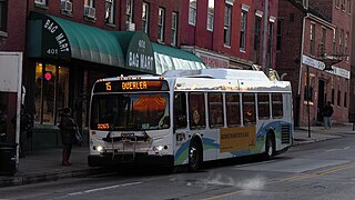
Route 15 is a bus route operated by the Maryland Transit Administration in Baltimore and its suburbs. The line currently runs from Security Square Mall, Westview Mall, Windsor Hills, or Walbrook Junction through downtown Baltimore and northeast to Overlea, with selected peak hour express trips to Perry Hall. The main roads on which it operates include Security Boulevard, Windsor Mill Road, Forest Park Avenue, Poplar Grove Street, Edmondson Avenue, Saratoga Street, Gay Street, and Belair Road, and is one of the most heavily used bus routes operated by the MTA.
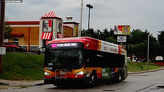
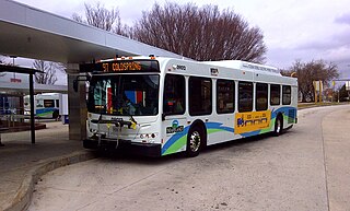
CityLink Pink is a bus route operated by the Maryland Transit Administration in Baltimore. The line currently runs from Cedonia in northeast Baltimore to the West Baltimore MARC station.

Mondawmin station is a Metro SubwayLink station in Baltimore, Maryland. It is located under the intersection of Reisterstown Road and Liberty Heights Avenue in the Mondawmin neighborhood, adjacent to the Mondawmin Mall. It is the northernmost underground station on the line, and a major transfer point to many bus routes.

Coppin Heights/Ash-Co-East is a predominately African-American working-class neighborhood in West Baltimore, Maryland. It is located south of North Avenue, west of N Smallwood Street, east of N Dukeland Street, and approximately north of the railroad tracks. The community was originally called "Ash Co. East" (Ash-Co-East). In 1989, it was renamed Coppin Heights. The name "Coppin" is from Fanny Jackson Coppin a pioneering black educator.
Forest Park is a region of Northwest Baltimore, Maryland located west of Reisterstown Road, south of Northern Parkway, and east of the Baltimore City/County line. In Baltimore, the region is referred to by locals simply as "Forest Park" and includes the neighborhoods of Ashburton, Callaway-Garrison, Central Forest Park, Dolfield, Dorchester, East Arlington, Forest Park, Grove Park, Hanlon Longwood, Howard Park, Garwyn Oaks, Purnell, West Arlington, West Forest Park, and Windsor Hills.

Windsor Mill Road is a road that runs through parts of Baltimore, Maryland and its western suburb Woodlawn. The road starts as a one-way street named Edgewood Street, then makes a slight left corner and becomes Windsor Mill Road. The road, which is approximately 7+1⁄2 miles in length, runs parallel to nearby Liberty Road and Security Boulevard, and is often used as an alternative to these routes. Though Windsor Mill Road has no interchange with the Baltimore Beltway, it crosses over the highway, and this point is frequently mentioned in traffic reports.
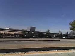
Mondawmin Mall is a three-level shopping mall in West Baltimore, Maryland, United States. The mall was a development of the Mondawmin Corporation, a firm set up in 1952 by James Rouse and Hunter Moss under the Moss-Rouse Company. When it first opened in October 1956, it had an open-air plan and was called the Mondawmin Center. It was later enclosed and renamed the Mondawmin Mall.

Walbrook is a neighborhood in West Baltimore, located along West North Avenue. Coppin State University is located in Walbrook, and the neighborhood was also the namesake of the former Walbrook High School.

Mosher is a neighborhood in the western part of Baltimore, Maryland. Its boundaries are the north side of Edmondson Avenue, the west side of Braddish Avenue, the east side of Poplar Grove, and the south side of Riggs Avenue. The neighborhood lies in the vicinity of Walbrook Junction, Coppin State University, Sandtown-Winchester, and Edmondson Village. Mosher is one of several neighborhoods that resisted the development of the "Road to Nowhere", now designated as US 40, along the Franklin Avenue corridor. The area was historically segregated, and largely occupied by European Americans, but transitioned during the early 1950s to become a predominantly African American area.

Bridgeview/Greenlawn is a neighborhood in the western part of Baltimore, Maryland. Its boundaries are the north side of West Lafayette Street, the east side of Braddish Avenue, the west side of North Monroe Street, and the south side of Presstman Street. The neighborhood lies in the vicinity of Walbrook Junction, Coppin State University, Sandtown-Winchester, and Edmondson Village. Though the area was once considered middle-class, it has in the 20th century experienced economic depression, housing abandonment, crime and gang problems. It is populated largely by lower income African American residents and is a neighborhood where Bloods gang members are concentrated.
Route 82, also known as the Mondawmin Shuttle Bug or Mondawmin Shuttle, is one of two neighborhood shuttle routes operated by the Maryland Transit Administration in Baltimore. It was the second and is so far the final in the series of shuttle bus routes to be introduced by MTA in the 2000s. The route serves Baltimore City Community College, Coppin State College, and various nearby streets, some served by regular bus routes, and some not. But the full route is within a close walk of one or more other MTA bus routes. The route operates at 25-minute intervals.
Dorchester is a neighborhood in the Northwest District of Baltimore. It is located between the neighborhoods of Arlington (north), Central Forest Park (south), Howard Park (west) and Gallway-Garrison (east). Maryland Route 26 draws boundary between Dorchester and Central Forest Park. Dorchester's other boundaries are marked by Oakford Avenue, Eldorado Avenue and Garrison Boulevard.
Edgecomb, also known as Parklane, is a neighborhood in the North District of Baltimore, located between the neighborhoods of Cylburn (north) and Greenspring (south). Its boundaries are marked by Dupont Avenue (north), Coldspring Lane (south), Pimlico Road (west) and Greenspring Avenue (east). Central Park Heights, is located on the opposite side of Pimlico Road in the Northwest District. The neighborhood of Coldspring is located to Edgecomb's east, across Greenspring Avenue.
Callaway-Garrison is a neighborhood in the Northwest district of Baltimore, located between the neighborhoods of Dorchester (west) and Ashburton (east). Its boundaries are marked by West Cold Spring Lane (north), Liberty Heights Avenue (south), Callaway Avenue (east) and Garrison Boulevard (west).
Mount Holly is a neighborhood in the Southwest District of Baltimore, located between the neighborhoods of Fairmont (south), Walbrook (east) and Garwyn Oaks (north). Its boundaries are drawn by Denison Street (east), Clifton Avenue (southwest), Gwynns Falls Parkway (north), Windsor Mill Road (northwest), and West North Avenue (south). Gwynns Falls Leakin Park is located to the west of Mount Holly.

Penn-North is a neighborhood in the city of Baltimore, Maryland, United States. It is located southwest of Druid Hill Park, west of Reservoir Hill, north of Bolton Hill, and east of Mondawmin. It is bounded Northeast by the Druid Park Lake Drive, the West and Northwest by Fulton Ave., the South by North Avenue, and East by McCulloh Street. It is contained in the 21217 ZIP code.

The West Baltimore Innovation Village District is a neighborhood district of Baltimore City that will specialize in attracting startup companies and other employers to West Baltimore. Following the Death of Freddie Gray and the subsequent 2015 Baltimore protests, government leaders decided to launch the innovation district as a way to attract redevelopment and revitalization to the areas hardest hit by the protests. The district includes the neighborhoods of Mondawmin, Coppin Heights, Penn-North, Reservoir Hill and Bolton Hill.