Reservoir Hill, Baltimore

Last updated

Reservoir Hill Historic District
Res Hill HD Baltimore.JPG
Reservoir Hill Historic District, March 2012
Baltimore osm-mapnik location map.png
Red pog.svg
USA Maryland location map.svg
Red pog.svg
Usa edcp location map.svg
Red pog.svg
LocationNorth Ave.--Madison Ave.--Druid Park Lake Dr.--Mt. Royal Terrace, Baltimore, Maryland
Coordinates 39°18′54″N76°38′0″W / 39.31500°N 76.63333°W / 39.31500; -76.63333
Area200 acres (81 ha)
Architectural styleEarly Republic, Late Victorian
NRHP reference No. 04001376 [1]
Added to NRHPDecember 23, 2004

Reservoir Hill is a historic neighborhood in the city of Baltimore, Maryland, United States. It is located south of Druid Hill Park, north of Bolton Hill, east of Penn-North, and west of Jones Falls. It is bounded by Druid Park Lake Drive, the Jones Falls Expressway, North Avenue (U.S. Route 1), and McCulloh Street. It is contained in the 21217 ZIP code.

Contents

About the area

Reservoir Hill has some of the best examples of Victorian, Italianate and Second Empire style homes in Baltimore. The housing stock features a wide variety of nineteenth century architecture, including ornate Victorian mansions overlooking the Druid Hill Park, brownstones, and the smaller brick rowhouses that characterize much of Baltimore. Part of Reservoir Hill is a historic district listed on the National Register of Historic Places. Recent restoration efforts have begun to revert the neighborhood back to its prominent stature. [2]

Portions of Reservoir Hill are within easy walking distance of the North Avenue station on the Baltimore Light Rail line and the Penn-North station on the Baltimore Metro Subway, as well as Pennsylvania Station on Amtrak's Northeast Corridor.

During the late 19th and early 20th centuries, Baltimore was the second largest port for immigrants coming to the United States behind Ellis Island of New York, and many of these immigrants lived in Reservoir Hill. Many came over from the Russian Empire (mostly Jews and Ukrainians), and certain parts of Reservoir Hill housed many migrants from other parts of Eastern Europe. The neighborhood is now majority African-American. [3]

A synagogue originally built in Reservoir Hill by the Chizuk Amuno Congregation in 1922 is now the home of Beth Am, one of two non-Orthodox Jewish congregations located within the city limits of Baltimore.

Mount Royal

A section of Reservoir Hill is known as Mount Royal. It is just across North Avenue from Bolton Hill and close to the Jones Falls. It is generally more expensive and contains very well preserved homes. A portion of this has been declared the Mount Royal Terrace Historic District by Baltimore City.

Notable residents

Writer Gertrude Stein lived in Reservoir Hill for a short period of time on Linden Avenue, near Whitelock Street in what is also called the David Bachrach House. [4]

Pulitzer Prize winning poet Karl Shapiro was born on Brooks Lane in Reservoir Hill. Shapiro was appointed the fifth Poet Laureate Consultant in Poetry to the Library of Congress in 1946. [5]

Soviet spy Whittaker Chambers and suspected spy Alger Hiss lived in the area. Hiss grew up on 1427 Linden Avenue. Chambers lived on Mount Royal Terrace just prior to his defection from the Soviet Underground in April 1938. Earlier in the 1930s, he lived on Eutaw Place. Spy photographer Felix Inslerman worked for Chambers and lived on Callow Avenue. [6] [7]

Mt. Royal Terrace (1890-1940)

The Baltimore City directories from Enoch Pratt Free Library indicate that many residents of Mt. Royal lived in their homes for several decades. It was a community based neighborhood where everyone knew each other. [8] The Baltimore City directories also show that many residents were employees of blue collar companies. Many people from these blocks were either factory workers, construction workers, electricians, police officers, nurses, etc. The historical Baltimore Sun contains a vast amount of information regarding residents of Mt. Royal Terrace between 1890 - 1940.

Many residents of Mt. Royal lived quiet hard working lives. One man named Samuel W. Filbert is an example of a common Mt. Royal resident. Filbert resided on 2200 Mt. Royal Terrace with his wife "Miss May (Filbert). [9] Samuel, like many of the Mt. Royal residents worked a rigorous blue collar job as a construction worker for the "Filbert Paving and Construction Company." [10] It was a family owned business located in Baltimore. Samuel was the General manager of the company until he joined the military. Like many young men, Filberts career was affected by World War I. Filbert became a soldier in the 4th Maryland Regiment where he would soon be promoted to Lieutenant - Colonel of the infantry. [11] Filbert became a very decorated military figure in the Mt. Royal area. He was held several titles in the 4th Regiment of Maryland including Captain and Lieutenant - Colonel.

Samuel W. Filbert represented the common lifestyle of a resident in not only the Mt. Royal area, but Baltimore city during the late 19th and early 20th centuries. The people in these areas were very hard working, communal, and loyal to the area. Many of the residents passed their homes off to their children, nephews, and nieces. 1890–1940 was a hard time in American history. The Great Depression greatly affected many lives during the 1920s, 30s and 40s. Many residents of Baltimore lost job opportunities. Many young men took advantage of joining the military. The Filbert Paving and Construction Company went out of business right after the stock market crash of 1929. Samuel Filbert elected to join the military in order to earn some type of wage. In the military he was fortunate enough to become very successful. Despite The Great Depression, Mt. Royal still remained very much alive.

Eutaw Place and Madison Park

Eutaw Place and Madison Park is also designated as a historic district. It is located on the western side of Reservoir Hill. This section of the neighborhood includes many grand houses on Eutaw Place and Madison Avenue, as well three large apartment buildings that are located directly across from Druid Hill Park on Madison and Eutaw. [12] Chauncey Brooks' mansion Cloverdale was once located in this area.

Demographics

Related Research Articles

<span class="mw-page-title-main">Hampden, Baltimore</span> Neighborhood of Baltimore in Maryland, United States

Hampden is a neighborhood located in northern Baltimore, Maryland, United States. Roughly triangular in shape, it is bounded to the east by the neighborhood Wyman Park, to the north by Roland Park at 40th and 41st Street, to the west by the Jones Falls Expressway, and to the south by the neighborhood Remington. The Homewood campus of the Johns Hopkins University is a short distance to the east.

<span class="mw-page-title-main">Mount Vernon, Baltimore</span> Neighborhood in Baltimore, Maryland, United States

Mount Vernon is a neighborhood of Baltimore, Maryland, located immediately north of the city's downtown. It is named for George Washington's Mount Vernon estate in Virginia, as the site of the city's Washington Monument.

<span class="mw-page-title-main">Hans Schuler</span> American sculptor (1874–1951)

Hans K. Schuler was a German-born American sculptor and monument maker. He was the first American sculptor ever to win the Salon Gold Medal. His works are in several important museum collections, and he also created many public monuments, mostly for locations in Baltimore, Maryland and in the Washington, D.C. area. For over a quarter of a century he served as president of the Maryland Institute College of Art.

<span class="mw-page-title-main">Druid Hill Park</span> Urban park in Baltimore, Maryland, US

Druid Hill Park is a 745-acre (3.01 km2) urban park in northwest Baltimore, Maryland. Its boundaries are marked by Druid Park Drive (north), Swann Drive and Reisterstown Road, and the Jones Falls Expressway / Interstate 83 (east).

<span class="mw-page-title-main">Bolton Hill, Baltimore</span> Neighborhood of Baltimore in Maryland, United States

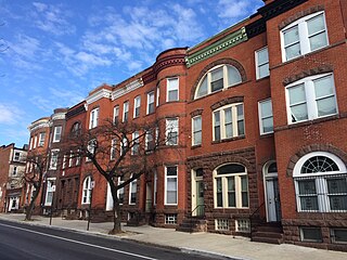
Bolton Hill is a neighborhood in Baltimore, Maryland, with 20 blocks of mostly preserved buildings from the late 19th century. It is listed on the National Register of Historic Places, preserved as a Baltimore City Historic District, and included within the boundaries of Baltimore National Heritage Area. The neighborhood is bounded by North Avenue, Mount Royal Avenue, Cathedral Street, Dolphin Street, and Eutaw Place. Bolton Hill is a largely residential neighborhood with three-story row houses with red brick, white marble steps, and high ceilings. There are also larger more ornate originally single-family houses, many houses of worship, parks, monuments, and a few large apartment buildings. Many significant residents have lived in the neighborhood, including F. Scott Fitzgerald, Woodrow Wilson, the Cone sisters, and Florence Rena Sabin.

<span class="mw-page-title-main">Mondawmin, Baltimore</span> Neighborhood of Baltimore in Maryland, United States

Mondawmin is a neighborhood located in the Western district of Baltimore, Maryland, United States. The neighborhood is surrounded by Druid Hill Park, the Whitelock Community, and Lower Park Heights. Included within its boundaries are Frederick Douglass High School, and Mondawmin Mall. The Baltimore Metro Subway serves the neighborhood, with a station at Mondawmin Mall that is also a hub for many bus routes.

<span class="mw-page-title-main">Mount Washington, Baltimore</span> United States historic place

Mount Washington is an area of northwest Baltimore, Maryland. It is a designated city historic district and divided into two sections: South Road/Sulgrave to the southeast and Dixon's Hill to the north. The Mount Washington Historic District was listed on the National Register of Historic Places in 1990 with a boundary increase in 2001, with five contributing buildings and four contributing structures.

<span class="mw-page-title-main">Butchers Hill, Baltimore</span> Historic house in Maryland, United States

Butchers Hill is a neighborhood in Southeast Baltimore, Maryland, United States. It is north of Fells Point, east of Washington Hill, and northwest of Patterson Park. It is south of Fayette Street, west of Patterson Park Avenue, north of Pratt Street, and east of Washington Street. It is in the 21231 zip code.

<span class="mw-page-title-main">Maryland Route 129</span> State highway in Maryland, US

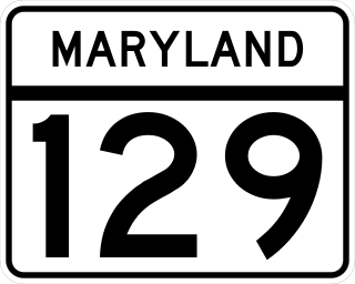
Maryland Route 129 is a state highway in the U.S. state of Maryland, running north-northwesterly from U.S. Route 40 and MD 295 in the city of Baltimore into Baltimore County, ending at Garrison Forest Road east of Reisterstown. The route leaves downtown on the one-way pair of McCulloh Street and Druid Hill Avenue, and then uses the entire length of Park Heights Avenue to the end. MD 129 connects Downtown Baltimore with Druid Hill Park using McCulloh Street and Druid Hill Avenue. As Park Heights Avenue, the state highway is one of two primary radial routes in the northwestern part of the city, providing access to The Maryland Zoo and Pimlico Race Course. In Baltimore County, MD 129 passes through Pikesville, where it has a junction with Interstate 695 (I-695) and serves an affluent rural area north of Pikesville and east of Reisterstown.

<span class="mw-page-title-main">Mayfield, Baltimore</span> United States historic place

Mayfield is a quaint and historic community in northeast Baltimore, Maryland. It is bounded by Erdman Avenue on the south, Chesterfield Avenue on the north, Crossland Avenue on the east and Lake Montebello on the north and west. Homeowners belong to the Mayfield Improvement Association.

George Aloysius Frederick was a German-American architect with a practice in Baltimore, Maryland, where his most prominent commission was the Baltimore City Hall (1867–1875), awarded him when he was only age 21. Later in the late 19th century, he served as the semi-official municipal architect.

<span class="mw-page-title-main">Leadenhall Street Baptist Church</span> Historic church in Maryland, United States

Leadenhall Street Baptist Church is a historic Baptist church located at Baltimore, Maryland, United States. It is a gable-front rectangular brick temple with simple Renaissance Revival detail. The original exterior wall surfaces have been covered with formstone on the main façade and stucco elsewhere. It features round-arched stained glass windows on each side bay. It was built in 1873, by Joseph Thomas & Son for the city's African American Baptists who were then centered in the old southwest area from the downtown business district of Baltimore in the "Sharp-Leadenhall" community in the old "South Baltimore" area. Nearby is its now famed revitalized "Inner Harbor" area of the old "Basin" for the harbor port.

<span class="mw-page-title-main">Eutaw–Madison Apartment House Historic District</span> Historic district in Maryland, United States

Eutaw–Madison Apartment House Historic District is a national historic district in Baltimore, Maryland, United States. It consists of a group of three multi-story apartment buildings built in the first quarter of the 20th century. They are: The Esplanade, a 9-story apartment building built in 1912; the Emersonian, an 8-story building constructed in 1915 of stuccoed masonry; and Temple Gardens, a 14-story building built in 1926. The district is significant in part because of its association with Baltimore's Jewish community. During the 19th century, the Eutaw–Madison neighborhood became a center for the Jewish community in Baltimore. By the 1920s the neighborhood had been established firmly as a neighborhood of middle and upper-class Jews, many of whom were professionals and merchants.

Charles L. Carson, was an architect born in Baltimore, the oldest son of Daniel Carson, a builder, and one of the founders of the Baltimore chapter of AIA. Carson had little formal training as an architect. Around 1870 he partnered with Thomas Dixon (architect) while taking drawing lessons at the Maryland Institute College of Art. Carson and Dixon worked from their offices at 117 Baltimore Street as Thomas Dixon and Charles L. Carson until sometime before 1877 when the partnership was dissolved. In 1888 he hired Joseph Evans Sperry who became his chief assistant, and later his partner and successor.

<span class="mw-page-title-main">East Monument Historic District</span> Historic district in Maryland, United States

East Monument Historic District or Little Bohemia, is a national historic district in Baltimore, Maryland. It is a large residential area with a commercial strip along East Monument Street. It comprises approximately 88 whole and partial blocks. The residential area is composed primarily of rowhouses that were developed, beginning in the 1870s, as housing for Baltimore's growing Bohemian (Czech) immigrant community. During the late 19th and early 20th centuries the neighborhood was the heart of the Bohemian community in Baltimore. The Bohemian National Parish of the Roman Catholic Church, St. Wenceslaus, is located in the neighborhood. The historic district includes all of McElderry Park and Milton-Montford, most of Middle East and Madison-Eastend, and parts of Ellwood Park.

<span class="mw-page-title-main">Jones Falls Trail</span> Hiking and bicycling trail in Baltimore, Maryland, United States

Jones Falls Trail is a hiking and bicycling trail in Baltimore, Maryland. It mostly runs along the length of the namesake Jones Falls, a major north–south stream in and north of the city that has long acted as a major transportation corridor for the city. It also incorporates the bike path encircling Druid Hill Reservoir and its namesake park. The Jones Falls Trail forms a segment of the East Coast Greenway, a partially completed network of off-road bicycling routes that runs the length of the East Coast.

<span class="mw-page-title-main">Madison Park, Baltimore</span> Neighborhood in Baltimore

Madison Park is a neighborhood in west Baltimore.

<span class="mw-page-title-main">Lafayette Square (Baltimore)</span> Historic site

Lafayette Square, is a historic city park and district in the Sandtown-Winchester area of West Baltimore, Maryland. It is bounded by Lanvale Street and Lafayette, Arlington, and Carrollton Avenues.

<span class="mw-page-title-main">West Baltimore Innovation District</span> Innovation district in Maryland, United States

The West Baltimore Innovation Village District is a neighborhood district of Baltimore City that will specialize in attracting startup companies and other employers to West Baltimore. Following the Death of Freddie Gray and the subsequent 2015 Baltimore protests, government leaders decided to launch the innovation district as a way to attract redevelopment and revitalization to the areas hardest hit by the protests. The district includes the neighborhoods of Mondawmin, Coppin Heights, Penn-North, Reservoir Hill and Bolton Hill.

References

  1. "National Register Information System". National Register of Historic Places . National Park Service. March 13, 2009.
  2. Fred B. Shoken (June 2004). "National Register of Historic Places Registration: Reservoir Hill Historic District" (PDF). Maryland Historical Trust. Retrieved March 1, 2016.
  3. "Incidents of Muslim hate-bias have more than tripled in Maryland since October 7th". WYPR . Retrieved November 4, 2023.
  4. Kelly, Jacques (November 29, 2013). "A Baltimore house known for its famous residents is brought back to life". Baltimore Sun. Retrieved November 20, 2014.
  5. Baltimore Sun. "Obituary for Karl Shapiro"
  6. Chambers, Whittaker (1952). Witness . New York: Random House. pp.  26 (Mount Royal Terrace), 42 (defection), 46 (detection), 84 (mention), 393–394 (Eutaw Place). LCCN   52005149.
  7. Kelly, Jacques (April 13, 1997). "Taking a spy turn through city's neighborhoods". Baltimore Sun. Retrieved September 29, 2015.
  8. Enoch Pratt Free Library
  9. "Bride is Well Known" Baltimore Sun. August 7, 1903. Pro Quest Historical Newspapers. The Historical Baltimore Sun
  10. "Brick and Clay Record." University of Michigan. August 1917.
  11. "Captain Filbert Wins." Baltimore Sun. October 21, 1913. Pro Quest Historical Newspapers. Historical Baltimore Sun
  12. "Eutaw Place and Madison Park". Baltimore City CHAP. November 15, 2015.
  13. Census Demographic Profiles. "2010 United States Census".