
Elkridge is an unincorporated community and census-designated place (CDP) in Howard County, Maryland, United States. The population was 15,593 at the 2010 census. Founded early in the 18th century, Elkridge is adjacent to two other counties, Anne Arundel and Baltimore.

Federal Hill is a neighborhood in Baltimore, Maryland, United States that lies just to the south of the city's central business district. Many of the structures are included in the Federal Hill Historic District, listed on the National Register of Historic Places in 1970. Other structures are included in the Federal Hill South Historic District, listed in 2003.

Mount Vernon is a neighborhood of Baltimore, Maryland, located immediately north of the city's downtown district. Designated a National Historic Landmark District and a city Cultural District, it is one of the city's oldest neighborhoods and originally was home to the city's wealthiest and most fashionable families. The name derives from the Mount Vernon home of George Washington; the original Washington Monument, a massive pillar commenced in 1815 to commemorate the first president of the United States, is the defining feature of the neighborhood.

Druid Hill Park is a 745-acre (3.01 km2) urban park in northwest Baltimore, Maryland. Its boundaries are marked by Druid Park Drive (north), Swann Drive and Reisterstown Road, and the Jones Falls Expressway / Interstate 83 (east).

Canton is a historic waterfront neighborhood in Baltimore, Maryland, United States. The neighborhood is along Baltimore's outer harbor in the southeastern section of the city, roughly two miles east of Baltimore's downtown district and next to or near the neighborhoods of Patterson Park, Fell's Point, Highlandtown, and Brewers Hill.

Bolton Hill is a neighborhood in Baltimore, Maryland, with 20 blocks of mostly preserved buildings from the late 19th century. It is listed on the National Register of Historic Places, preserved as a Baltimore City Historic District, and included within the boundaries of Baltimore National Heritage Area. The neighborhood is bounded by North Avenue, Mount Royal Avenue, Cathedral Street, Dolphin Street, and Eutaw Place. Bolton Hill is a largely residential neighborhood with three-story row houses with red brick, white marble steps, and high ceilings. There are also larger more ornate originally single-family houses, many houses of worship, parks, monuments, and a few large apartment buildings. Many significant residents have lived in the neighborhood, including F. Scott Fitzgerald, Woodrow Wilson, the Cone sisters, and Florence Rena Sabin.

Cylburn Arboretum [pronounced sil·brn aar·br·ee·tm] is a city park with arboretum and gardens, located at 4915 Greenspring Avenue, Baltimore, Maryland. It is open daily – excluding Mondays – without charge.

The Battle Monument, located in Battle Monument Square on North Calvert Street between East Fayette and East Lexington Streets in Baltimore, Maryland, commemorates the Battle of Baltimore with the British fleet of the Royal Navy's bombardment of Fort McHenry, the Battle of North Point, southeast of the city in Baltimore County on the Patapsco Neck peninsula, and the stand-off on the eastern siege fortifications along Loudenschlager and Potter's Hills, later called Hampstead Hill, in what is now Patterson Park since 1827, east of town. It honors those who died during the month of September 1814 during the War of 1812. The monument lies in the middle of the street and is between the two Baltimore City Circuit Courthouses that are located on the opposite sides of North Calvert Street. It was sponsored by the City and the "Committee of Vigilance and Safety" led by Mayor Edward Johnson and military commanders: Brig. Gen. John Stricker, Maj. Gen. Samuel Smith and Lt. Col. George Armistead.

The First Unitarian Church is a historic church and congregation at 12 West Franklin Street in Baltimore, Maryland. Dedicated in 1818, it was the first building erected for Unitarians in the United States. The church is a domed cube with a stucco exterior. The church, originally called the "First Independent Church of Baltimore", is the oldest building continuously used by a Unitarian congregation. The name was changed in 1935 to "The First Unitarian Church of Baltimore " following the merger with the former Second Universalist Church at East Lanvale Street and Guilford Avenue in midtown Baltimore. The American Unitarian Association and the Universalist Church of America (established 1866) representing the two strains of Unitarian Universalism beliefs and philosophies merged as a national denomination named the Unitarian Universalist Association in May 1961.

The College of Medicine of Maryland, or also known since 1959 as Davidge Hall, is a historic domed structure in Baltimore, Maryland. It has been in continuous use for medical education since 1813, the oldest such structure in the United States. A wide pediment stands in front of a low, domed drum structure, which housed the anatomical theater. A circular chemistry hall was housed on the lower level under the anatomical theater.
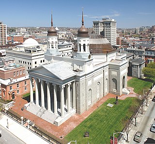
The Cathedral Hill Historic District is an area in Baltimore, Maryland. It lies in the northern part of Downtown just south of Mount Vernon. Roughly bounded by Saratoga Street, Park Avenue, Hamilton Street, and St. Paul Street, these 10 or so blocks contain some of the most significant buildings in Baltimore. The area takes its name from the Basilica of the Assumption which sits in the heart of the district. Despite the number of large religious structures in the area, the district's buildings are primarily commercial in character, with a broad collection of significant commercial structures ranging in date from 1790 to 1940.

The National Register of Historic Places listings in the city of Baltimore, Maryland covers the 299 properties and historic districts listed on the National Register of Historic Places in the independent city of Baltimore, Maryland. NRHP listings in Baltimore County, which surrounds but does not include the city, are in the National Register of Historic Places listings in Baltimore County, Maryland.
This is a list of National Register of Historic Places properties and districts in downtown Baltimore, Maryland, United States. Many other properties are located in other parts of the city; for these, see National Register of Historic Places listings in Baltimore, Maryland.

The Fifth Regiment Armory is a historic National Guard armory located in Baltimore, Maryland, United States. It is an imposing, fortress-type structure situated in midtown Baltimore. It consists of a full basement, a first floor containing a 200 foot by 300 foot drill hall, a mezzanine or "balcony" level, and a newer second level housing the trussed steel drill hall roof. The façade features buttresses, parapets, casement windows, and a crenellated roofline, giving the appearance of a medieval fortification. It was the site of the 1912 Democratic National Convention.

Market Center is a national historic district in Baltimore, Maryland, United States. It is an approximately 24-block area in downtown Baltimore that includes buildings associated with the development of the area as Baltimore's historic retail district. The area evolved from an early 19th-century neighborhood of urban rowhouses to a premiere shopping district featuring large department stores, grand theaters, and major chain stores. The diverse size, style, scale, and types of structures within the district reflect its residential origins and evolution as a downtown retail center.
Baltimore Heritage is an American nonprofit historic-preservation organization headquartered in Baltimore, Maryland.

East Monument Historic District or Little Bohemia, is a national historic district in Baltimore, Maryland. It is a large residential area with a commercial strip along East Monument Street. It comprises approximately 88 whole and partial blocks. The residential area is composed primarily of rowhomes that were developed, beginning in the 1870s, as housing for Baltimore's growing Bohemian (Czech) immigrant community. During the late 19th and early 20th centuries the neighborhood was the heart of the Bohemian community in Baltimore. The Bohemian National Parish of the Roman Catholic Church, St. Wenceslaus, is located in the neighborhood. The historic district includes all of McElderry Park and Milton-Montford, most of Middle East and Madison-Eastend, and parts of Ellwood Park.

Zion Lutheran Church, also known as the Zion Church of the City of Baltimore, is a historic Evangelical Lutheran church located in downtown Baltimore, Maryland, United States, founded 1755.

Hollins–Roundhouse Historic District is a national historic district in Baltimore, Maryland, United States. It is a primarily residential area characterized by 19th century rowhouses. The neighborhood is historically significant due to its association with the development of rail transportation in Maryland. Additional historical significance comes from the neighborhood's association with ethnic immigration to Baltimore. During the 1840s and 1850s the area was a center of settlement for Baltimore's German and Irish communities, many of whom immigrated to the United States to work in the rail industry. Later, from the 1880s to the 1920s, the neighborhood became established as the center of Baltimore's Lithuanian immigrant community. Because of the large Lithuanian population in the area north of Hollins Street, the area became known as Little Lithuania. A few remnants of the neighborhood's Lithuanian heritage still remain, such as Lithuanian Hall located on Hollins Street.

Midtown-Edmondson is a mixed-use neighborhood in western Baltimore City developed mostly between the 1880s and the 1910s. The neighborhood is mainly composed of residential rowhouses, with a mixed-used business district along Edmondson Avenue, and industrial warehouses and buildings dotted along the CSX railroads that bound its western edge.


