
Patapsco High School and Center For The Arts is a public high school in the United States, located in Dundalk in Baltimore County, Maryland, near Baltimore.

Southwest Philadelphia is a section of Philadelphia, Pennsylvania, United States. The section can be described as extending from the western side of the Schuylkill River to the city line, with the SEPTA. The northern border is defined by the Philadelphia City Planning Commission as east from the city line along Baltimore Avenue moving south along 51st Street to Springfield Ave. It follows the train tracks until 49th Street. From 49th and Kingsessing Ave the line moves east along Kingsessing Ave. The line then moves south along 46th St to Paschall Ave where it jogs to join Grays Ferry where the line runs to the Schuylkill River.

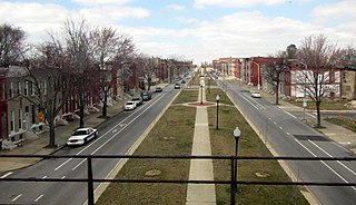
Carrollton Ridge is a neighborhood of South Baltimore, Maryland, United States

Middle East is a neighborhood in the heart of East Baltimore, Maryland.

Sandtown-Winchester is a neighborhood in West Baltimore, Maryland. Known locally as Sandtown, the community's name was derived from the trails of sand that dropped from wagons leaving town after filling up at the local sand and gravel quarry back in the days of horse-drawn wagons. It is located north of Lafayette Street, west of Fremont Avenue, south of North Avenue, and east of Monroe Street, covering an area of 72 square blocks, patrolled by the Baltimore Police Department's Western District. The community is 98.5% black.
Oliver is a neighborhood in the Eastern district of Baltimore, Maryland. Its boundaries are the south side of North Avenue, the east side of Ensor Street, the west side of Broadway, and the north side of Biddle Street. This neighborhood, adjacent to Johns Hopkins Medical Campus and minutes from the Inner Harbor, lies east of the historic Greenmount Cemetery. The neighborhood is accessible by several bus lines, the Johns Hopkins metro station, Charm City Circulator, Pennsylvania Station (Baltimore), and freeway.

Greenmount West is a neighborhood in the state-designated Station North Arts District of Baltimore City. Its borders consist of Hargrove Alley to the west, Hoffman Street and the Amtrak railroad tracks to the south, the south side of North Avenue to the north, and Greenmount Avenue to the east. Residents in the area include a mix of low, middle and high income families, artists, commuters to Washington DC and working-class Baltimoreans with the majority of residents of African American descent.
Forest Park is a region of Northwest Baltimore, Maryland located west of Reisterstown Road, south of Northern Parkway, and east of the Baltimore City/County line. In Baltimore, the region is referred to by locals simply as "Forest Park" and includes the neighborhoods of Ashburton, Callaway-Garrison, Central Forest Park, Dolfield, Dorchester, East Arlington, Forest Park, Grove Park, Hanlon Longwood, Howard Park, Garwyn Oaks, Purnell, West Arlington, West Forest Park, and Windsor Hills.
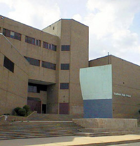
Southern High School was a former public secondary school on Warren Avenue between William Street to the west and Riverside Avenue to the east, in the Federal Hill neighborhood of the northern side of the larger old South Baltimore community on the Whetstone Point peninsula. With historic Fort McHenry from the War of 1812 (1812-1815), to the southeast at the point itself and additional residential areas surrounding the high school in tightly packed rowhouses and streets known as Locust Point and Riverside to the south and southeast along with the restored Otterbein and Sharp-Leadenhall neighborhoods to the west, also just south of the downtown central business district and famed "Inner Harbor" of the City of Baltimore, in Maryland.

Broadway East is a neighborhood in the East District of Baltimore. Its boundaries are the south side of North Avenue, the west side of Milton Street, the east side of Broadway, and the north side of Biddle Street. The neighborhood lies east of Oliver, north of Middle East, south of Lake Clifton, and west of Berea.

Berea is a neighborhood in the East District of Baltimore. Its boundaries are the south side of Sinclair Lane, the east side of Milton Avenue, the west side of Edison Highway, and the north side of Biddle Street. Berea lies between the neighborhoods of Broadway East (west) and Orangeville (east), north of the Biddle Street neighborhood and south of Four By Four.

Jonestown is a neighborhood in the southeastern district of Baltimore. Its boundaries are the north side of Pratt Street, the west side of Central Avenue, the east side of Fallsway, and the south side of Orleans Street. The neighborhood lies north of the Little Italy, south of the Old Town, west of the Washington Hill, and east of the Downtown Baltimore neighborhoods. The southern terminus of the Jones Falls Expressway is located here.

Medfield is a neighborhood located in north Baltimore, Maryland, United States of America. It is located to the north of the trendy Hampden neighborhood and south of affluent Roland Park neighborhood. Its unofficial boundaries are Coldspring Lane to the north; Jones Falls Expressway to the west; Falls Road/Hickory Avenue to the east; and West 41st Street to the south.
Rosemont is a neighborhood in the western part of Baltimore, Maryland. Located below North Avenue, above Franklintown Road, East of Hilton Parkway, and West of Bloomingdale Avenue it is a working class African-American neighborhood.

Mosher is a neighborhood in the western part of Baltimore, Maryland. Its boundaries are the north side of Edmondson Avenue, the west side of Braddish Avenue, the east side of Poplar Grove, and the south side of Riggs Avenue. The neighborhood lies in the vicinity of Walbrook Junction, Coppin State University, Sandtown-Winchester, and Edmondson Village. Mosher is one of several neighborhoods that resisted the development of the "Road to Nowhere", now designated as US 40, along the Franklin Avenue corridor. The area was historically segregated, and largely occupied by European Americans, but transitioned during the early 1950s to become a predominantly African American area.


Bridgeview/Greenlawn is a neighborhood in the western part of Baltimore, Maryland. Its boundaries are the north side of West Lafayette Street, the east side of Braddish Avenue, the west side of North Monroe Street, and the south side of Presstman Street. The neighborhood lies in the vicinity of Walbrook Junction, Coppin State University, Sandtown-Winchester, and Edmondson Village. Though the area was once considered middle-class, it has in the 20th century experienced economic depression, housing abandonment, crime and gang problems. It is populated largely by lower income African American residents and is a neighborhood where Bloods gang members are concentrated.
Gwynn's Falls is a neighborhood in the Southwestern District of Baltimore, located between Irvington (west) and Gwynns Falls Leakin Park (east). Frederick Avenue marks the neighborhood's boundary to the north; Wilkens Avenue draws its southern edge. Caton Avenue separates it from Irvington to the west.
The Orchards is a neighborhood in the North District of Baltimore, located between the neighborhoods of New North Roland Park–Poplar Hill and Bellona–Gittings. Its boundaries are marked by the Baltimore County line (north), Maryland Route 133 Northern Parkway (south), and Maryland Route 139 Charles Street (east). Roland Avenue, West Lake Avenue, Kenmore Road and Melrose Avenue draw the neighborhood's west boundary.

Harwood is a small neighborhood located in the north-central area of Baltimore, Maryland, USA. It sits east of Charles Village, south of Abell, west of Waverly and north of Barclay. Its boundaries are Guilford and Greenmount Avenues to the east and west, and 25th and 29th streets to the north and south. These streets together encompass about 14 city blocks.
