Anne Arundel County, also notated as AA or A.A. County, is located in the U.S. state of Maryland. As of the 2020 United States census, its population was 588,261, an increase of just under 10% since 2010. Its county seat is Annapolis, which is also the capital of the state. The county is named for Anne Arundell, Lady Baltimore, a member of the ancient family of Arundells in Cornwall, England, and the wife of Cecilius Calvert, 2nd Baron Baltimore (1605–1675), founder and first lord proprietor of the colony Province of Maryland.

Brooklyn Park is a census-designated place (CDP) in Anne Arundel County, Maryland, United States. The population was 14,373 at the 2010 census.

The Severn River is a tidal estuary 14 miles (23 km) long, located in Anne Arundel County in the U.S. state of Maryland, south of the Magothy River and north of the South River.

Maryland Route 648 is a collection of state highways in the U.S. state of Maryland. These nine highways are current or former sections of the Baltimore–Annapolis Boulevard between Annapolis and Baltimore via Glen Burnie. There are five signed mainline segments of MD 648 through Arnold, Severna Park, Pasadena, Glen Burnie, Ferndale, and Pumphrey in northern Anne Arundel County; Baltimore Highlands in southern Baltimore County; and the independent city of Baltimore. MD 648 mainly serves local traffic along its meandering route, with long-distance traffic intended to use the parallel and straighter MD 2 south of Glen Burnie and freeway-grade Interstate 97 (I-97), I-695, and MD 295 between Glen Burnie and Baltimore.
The Magothy River runs 12.1 miles (19.5 km) through Anne Arundel County in the U.S. state of Maryland. It is located south of the Patapsco River and north of the Severn River. There are two public park paddling access points, Beachwood Park on the north shore a half mile east of the Magothy Bridge Road bridge, and Spriggs Farm Park off Bayberry Drive, on the south shore two miles west of the Magothy's mouth. Both are Anne Arundel County parks.

Maryland Route 173 is a state highway in the U.S. state of Maryland. Known for most of its length as Fort Smallwood Road, the state highway runs 13.78 miles (22.18 km) from Fort Smallwood Park near Jacobsville north to MD 2 in the Brooklyn neighborhood of Baltimore. MD 173 connects the beach communities of Riviera Beach and Orchard Beach in northeastern Anne Arundel County and Interstate 695 (I-695) with industrial areas in the Baltimore neighborhoods of Hawkins Point and Curtis Bay, including the United States Coast Guard Yard. MD 173 was mostly constructed in the 1920s and early 1930s. The state highway was put in its modern form with the completion of the bridge over Stony Creek in the late 1940s and expansion to a divided highway between Orchard Beach and Curtis Bay in the late 1970s.

Westport is a neighborhood in south Baltimore, Maryland. Westport is a majority African-American neighborhood that has struggled with crime, housing abandonment, and unemployment in the past decade. The neighborhood is bordered by the Middle Branch of the Patapsco River on the east, the city neighborhoods of Cherry Hill, Brooklyn and the southwestern Baltimore County community of Lansdowne to the southwest, Hollins Ferry Road and the Mount Winans and Lakeland neighborhoods to the west, and Interstate 95 to the north, along with the South Baltimore communities of Federal Hill and Otterbein. The Baltimore–Washington Parkway runs through the middle of Westport and intersects with Interstate 95, the main East Coast super-highway, north to south, Maine to Florida.

The Helen Delich Bentley Port of Baltimore is a shipping port along the tidal basins of the three branches of the Patapsco River in Baltimore, Maryland, on the upper northwest shore of the Chesapeake Bay. It is the nation's largest port facility for specialized cargo and passenger facilities. It is operated by the Maryland Port Administration (MPA), a unit of the Maryland Department of Transportation.

Curtis Creek is a tidal creek located in Baltimore City and Anne Arundel County, Maryland. It is a tributary of the cove Curtis Bay and is adjacent to the west of the South Baltimore community of Curtis Bay. The creek begins at the confluence of Furnace Creek and Marley Creek in northern Anne Arundel County, Maryland and flows north about 2.5 miles (4.0 km) into Curtis Bay which opens to the east into the main branch and stem of the Patapsco River and Chesapeake Bay.

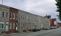
Brooklyn is one of the southernmost neighborhoods in Baltimore, Maryland. It is located near Anne Arundel County along Governor Ritchie Highway which is also Maryland Route 2. Its main roads are South Hanover Street,, Potee Street, and East Patapsco Avenue, Sixth Street, Tenth Street, and West Bay Avenue which borders the neighboring Curtis Bay community to the east, running through Bay Brook Park, which separates the two. South Hanover Street also serves as the dividing line between east–west streets in Brooklyn, as Charles Street does not exist here.

The Bethlehem-Fairfield Shipyard of Baltimore, Maryland, was a shipyard in the United States from 1941 until 1945. Located on the south shore of the Middle Branch of the Patapsco River which serves as the Baltimore Harbor, it was owned by the Bethlehem Shipbuilding Company, created by the Bethlehem Steel Corporation of Bethlehem, Pennsylvania, which had operated a major waterfront steel mill outside Baltimore to the southeast at Sparrows Point, Maryland in Baltimore County since the 1880s.
Arundel Cove Archaeological Site is an archaeological site near Baltimore in Anne Arundel County, Maryland. It is situated on the south shore of Arundel Cove, a tributary of Curtis Creek which drains into the Patapsco River. The site was discovered during routine shovel test pitting of the U.S. Coast Guard Yard at Curtis Bay in 1981. The test pits revealed that the site is small in size, extending only 20 feet north–south by 15 feet east–west. It represents the remains of a prehistoric summer camp which apparently was not repeatedly occupied. It contains a prehistoric period storage pits, with evidence of the use of galium and wild black cherry.
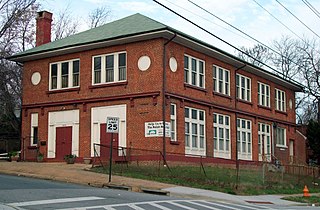
Polish Home Hall is a historic building located in the waterfront industrial/commercial/residential and heavily ethnic community of Curtis Bay in southern Baltimore, Maryland,. Built on the southwest corner of Fairhaven Avenue and Filbert Street near the top of the commanding heights overlooking to the east the sloping streets of the neighborhood of Curtis Bay, about four city blocks wide and 15 blocks length.

Fort Smallwood Park is a county park in northeastern Anne Arundel County, near Riviera Beach and Pasadena, Maryland, United States. It is located on the outer Patapsco River as it meets the Chesapeake Bay, on a peninsula known as Rock Point.
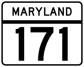
Maryland Route 171 is a state highway in the U.S. state of Maryland. Known as Church Street, the state highway runs 1.54 miles (2.48 km) from MD 2 in Brooklyn Park, Anne Arundel County, east to MD 173 in the Curtis Bay neighborhood of Baltimore. MD 171 was constructed in the mid-1920s.

"Mount Winans" is a mixed-use residential, commercial and industrial neighborhood in the southwestern area of the City of Baltimore in Maryland. Its north, south and east boundaries are marked by the various lines of track of the CSX Railroad. In addition, Hollins Ferry Road running to the south towards suburban Baltimore County in the southwest and further connecting with adjacent Anne Arundel County to the southeast, draws its western boundary.
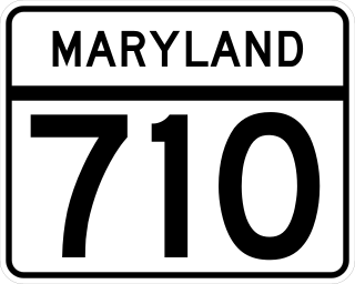
Maryland Route 710 is a state highway in the U.S. state of Maryland. Known as Ordnance Road, the state highway runs 2.16 miles (3.48 km) from MD 2 in Glen Burnie east to MD 173 in Brooklyn Park at the city limits of Baltimore. MD 710 provides access to the Defense Logistics Agency Curtis Bay Depot, a unit of the General Services Administration. The state highway is named for the federal site's prior use as a U.S. Army Depot. MD 710 was constructed in the early 1940s and relocated for most of its length concurrent with the construction of MD 10 in the early 1970s.

Hawkins Point is a neighborhood in the South District of Baltimore, located at the southern tip of the city between Curtis Bay (north) and the Anne Arundel County line (south) and Thoms Cove (east). Its land area covers 2.6 square miles (6.7 km2), and it had a population of 24 people according to the 2020 U.S. Census. The neighborhood is predominantly industrial.
Masonville was a residential community and suburban neighborhood of Baltimore, Maryland. Historically, the town was one of five neighboring communities sought and ultimately annexed by Baltimore City from Anne Arundel County in 1918. The town was razed in its entirety in the 1950s, to accommodate the expansion of the Baltimore & Ohio Railroad's Curtis Bay terminal.