Harborview is a waterfront community located in Baltimore, Maryland, United States. The community sits at the eastern base of the Federal Hill neighborhood in a former industrial area, occupied mainly by shipyards.
O'Donnell Heights is a neighborhood named for a public housing development in the far southeastern part of the city of Baltimore, Maryland, United States. It is located south and east of Interstate 95, just west of the border with Baltimore County, and north of the St. Helena neighborhood.
St Helena is the southeasternmost neighborhood in the city of Baltimore, Maryland. St. Helena is a neighborhood within the community of Dundalk. The Baltimore City/Baltimore County boundary line runs through St. Helena. So, St. Helena is located in both Baltimore County and Baltimore City. It has a mix of rowhouses and detached homes. It is divided by railroad tracks from the Point Breeze Industrial Park.
Loch Raven, Maryland is a neighborhood extending from northeast Baltimore city to the eastern part of Baltimore County, Maryland. The major road in the neighborhood is Loch Raven Blvd, which stretches all the way from the I-695 beltway in Baltimore county to 25th street in Baltimore city. It is located in the Baltimore Metro Area, and is considered as one of the longest roads in the area with many different aspects of Baltimore that can be seen by riding through the area. This region is a diverse, but still a predominantly African American part of the city and county, and is also the area that consists of a large amount of Morgan State University students. The zip codes assigned to this area are 21218, 21239, 21286, 21284,and 21234, which is also a Parkville, Maryland zip code.
Graceland Park is a neighborhood in Baltimore, Maryland, located adjacent O'Donnell Heights neighborhood. The neighborhood abuts the Baltimore City-Baltimore County line. The Baltimore County portion, Harbor View, is adjacent the community of Dundalk.
Coppin Heights is a neighborhood in the western part of Baltimore, Maryland. Located above North Avenue, it is a working-class neighborhood home to Coppin State University.
Violetville is a neighborhood in southwest Baltimore, Maryland and Baltimore County. The community is characterized by its "well-kept 1950s and 60s era rowhouses and older farmhouses that date back to the turn of the previous century."
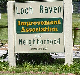
Loch Raven is a neighborhood in the Northeastern part of Baltimore, Maryland. It is located in the Upper Northwood Section of Northeast Baltimore east of Loch Raven Boulevard, west of Mount Pleasant Park, and borders the Baltimore City/County Line and served by the Loch Raven Improvement Association.
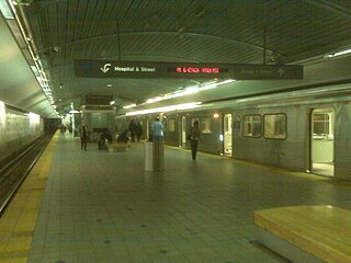
Johns Hopkins Hospital station is a Metro SubwayLink station in Baltimore, Maryland. It is located by Johns Hopkins Hospital, and is the final stop on the line.
East Baltimore Midway is a neighborhood in the Eastern district of Baltimore, Maryland. Its boundaries are the south side of 25th Street, the east side of Greenmount Avenue, the west side of Harford Road, and the north side of North Avenue.

Jonestown is a neighborhood in the southeastern district of Baltimore. Its boundaries are the north side of Pratt Street, the west side of Central Avenue, the east side of Fallsway, and the south side of Orleans Street. The neighborhood lies north of the Little Italy, south of the Oldtown, west of the Washington Hill, and east of the Downtown Baltimore neighborhoods. The southern terminus of the Jones Falls Expressway is located here.
Ramblewood is a small community located in northeast Baltimore, Maryland, United States. Ramblewood is located south of Northern Parkway with The Alameda serving as its western boundary and Loch Raven Blvd. as its eastern boundary and north of Belvedere Ave. The Ramblewood Community Association has had residential parking permits issued to its members as the result of the proliferation of students from Morgan parking in the neighborhood.
Frankford is a neighborhood located in northeastern Baltimore, Maryland, United States, also including the Moravia area. Major streets in the area include Frankford Avenue and Sinclair Lane. It is part of the Cedonia, Baltimore Region
Overlea is a neighborhood in northeast Baltimore. It is home to the Maryland School for the Blind.
Taylor Heights is a neighborhood in northeast Baltimore. The neighborhood contains only a few homes because Parkwood Cemetery takes up much of the neighborhood. A major road in the neighborhood is Taylor Avenue, which runs from Overlea in the east to Towson in the west, at which point it becomes Goucher Boulevard/Hillen Road.
The Orchards is a neighborhood in the North District of Baltimore, located between the neighborhoods of New North Roland Park–Poplar Hill and Bellona–Gittings. Its boundaries are marked by the Baltimore County line (north), Maryland Route 133 Northern Parkway (south), and Maryland Route 139 Charles Street (east). Roland Avenue, West Lake Avenue, Kenmore Road and Melrose Avenue draw the neighborhood's west boundary.
Lexington is a neighborhood in Baltimore, Maryland, United States. It is bordered by West Mulberry St to the north, West Baltimore St to the south, Monroe St to the east, and Warwick Ave to the west. The neighborhood consists primarily of rowhouses. It also encompasses Bon Secours Hospital, Bentalou Elementary School and Bentalou Recreation Center.
Liberty Square is a neighborhood in Baltimore, Maryland. African Americans make up the vast majority of residents.
Orchard Ridge, Baltimore is a neighborhood in the Northeastern part of Baltimore, Maryland, United States. It was formerly known as Claremont-Freedom. The neighborhood was redeveloped as a mixed tenancy, mixed-income community with 461 units. It includes both rental and homeownership townhouses, semi-detached homes, apartments and a community center.

The West Baltimore Innovation Village District is a neighborhood district of Baltimore City that will specialize in attracting startup companies and other employers to West Baltimore. Following the Death of Freddie Gray and the subsequent 2015 Baltimore protests, government leaders decided to launch the innovation district as a way to attract redevelopment and revitalization to the areas hardest hit by the protests. The district includes the neighborhoods of Mondawmin, Coppin Heights, Penn-North, Reservoir Hill and Bolton Hill.
