
Locust Point is a peninsular neighborhood in Baltimore, Maryland. Located in South Baltimore, the neighborhood is entirely surrounded by the Locust Point Industrial Area; the traditional boundaries are Lawrence street to the west and the Patapsco River to the north, south, and east. It once served as a center of Baltimore's Polish-American, Irish-American and Italian-American communities; in more recent years Locust Point has seen gradual gentrification with the rehabilitation of Tide Point and Silo Point. The neighborhood is also noted as being the home of Fort McHenry.

Mount Vernon is a neighborhood immediately north of downtown Baltimore, Maryland. Designated a National Historic Landmark District and a city Cultural District, it is one of the city's oldest neighborhoods and originally was home to the city's wealthiest and most fashionable families. The name derives from the Mount Vernon home of George Washington; the original Washington Monument, a massive pillar commenced in 1815 to commemorate the first president of the United States, is the defining feature of the neighborhood.

Canton is a historic waterfront neighborhood in Baltimore, Maryland, United States. The neighborhood is along Baltimore's outer harbor in the southeastern section of the city, roughly two miles east of Baltimore's downtown district and next to or near the neighborhoods of Patterson Park, Fell's Point, Highlandtown, and Brewers Hill.

Bolton Hill is a neighborhood in Baltimore, Maryland, with 20 blocks of mostly preserved buildings from the late 19th century. It is listed on the National Register of Historic Places, preserved as a Baltimore City Historic District, and included within the boundaries of Baltimore National Heritage Area. The neighborhood is bounded by North Avenue, Mount Royal Avenue, Cathedral Street, Dolphin Street, and Eutaw Place. Bolton Hill is a largely residential neighborhood with three-story row houses with red brick, white marble steps, and high ceilings. There are also larger more ornate originally single-family houses, many houses of worship, parks, monuments, and a few large apartment buildings. Many significant residents have lived in the neighborhood, including F. Scott Fitzgerald, Woodrow Wilson, the Cone sisters, and Florence Rena Sabin.

Butchers Hill is a neighborhood in Southeast Baltimore, Maryland, United States. It is north of Fells Point, east of Washington Hill, and northwest of Patterson Park. It is south of Fayette Street, west of Patterson Park Avenue, north of Pratt Street, and east of Washington Street. It is in the 21231 zip code.

Ridgely's Delight is an historic residential neighborhood in Baltimore, Maryland, United States. Its borders are formed by Russell and Greene Streets to the east, West Pratt Street to the north, and Martin Luther King Jr. Boulevard from the western to southern tips. It is adjacent to the University of Maryland, Baltimore, Oriole Park at Camden Yards, and M&T Bank Stadium. It is situated a short walk from MARC Train and the Light Rail's Camden Station, which has made it a popular residence of Washington, D.C. and suburban Baltimore commuters. It is within a 5-minute walk of both Oriole Park at Camden Yards and M&T Bank Stadium and a 10-minute walk from Baltimore's historic Inner Harbor.

Barre Circle is a small neighborhood in Baltimore, Maryland, United States. It is often considered to be a part of Pigtown. Most of the neighborhood's historic homes range from 1840 to 1890, with many populated by graduate students at the nearby University of Maryland's Baltimore campus. It is walking distance to the Inner Harbor and the MARC Train's Camden Station.

Northwood is a neighborhood in the northeastern section of Baltimore, Maryland in the United States. Northwood is served by the New Northwood and the Original Northwood community associations. The area is also home to the Northwood Shopping Center and the Northwood Baseball League. Morgan State University is located in this area.
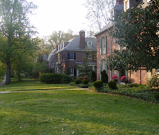
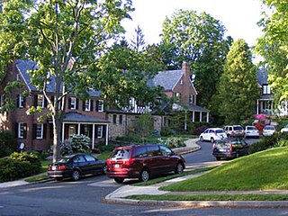
Guilford is a prominent and historic neighborhood located in the northern part of Baltimore, Maryland. It is bounded on the south by University Parkway, on the west by North Charles Street, Warrenton and Linkwood Roads, on the north by Cold Spring Lane and on the east by York Road. The neighborhood is adjacent to the neighborhoods of Tuscany-Canterbury, Loyola-Notre Dame, Kernewood, Wilson Park, Pen Lucy, Waverly Oakenshawe, Charles Village, and the universities of Johns Hopkins and Loyola University Maryland. The neighborhood was added to the National Register of Historic Places in 2001.

Ednor Gardens-Lakeside is a large community in northeast Baltimore, Maryland. It is bounded by 33rd Street to the south, Hillen Road to the east, Ellerslie Avenue to the west, and Argonne Drive, The Alameda, Loch Raven Boulevard, and Roundhill Road to the north. Ednor Gardens was part of a large planned community that was built out from the 1920s through the 1950s by Edward Gallagher, one of Baltimore's most prolific homebuilders at the time. It is notable among its neighbors for the quality of the homes and extensive landscaping. Until it was torn down in 2002, Memorial Stadium was located in Ednor Gardens-Lakeside.

Mayfield is a small community in northeast Baltimore, Maryland. It is bounded by Erdman Avenue on the south, Chesterfield Avenue on the north, Crossland Avenue on the east and Lake Montebello on the north and west. Homeowners belong to the Mayfield Improvement Association.
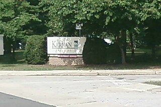
University of Maryland Rehabilitation & Orthopaedic Institute is a rehabilitation hospital located along the border of the Forest Park neighborhood of northwest Baltimore City and Woodlawn in Maryland. It lies on and is incorporated into the historic hospital building and grounds of the former James Lawrence Kernan Hospital. The hospital is now part of the University of Maryland Medical System, on the campus of the University of Maryland at Baltimore.

Market Center is a national historic district in Baltimore, Maryland, United States. It is an approximately 24-block area in downtown Baltimore that includes buildings associated with the development of the area as Baltimore's historic retail district. The area evolved from an early 19th-century neighborhood of urban rowhouses to a premiere shopping district featuring large department stores, grand theaters, and major chain stores. The diverse size, style, scale, and types of structures within the district reflect its residential origins and evolution as a downtown retail center.

Oakenshawe Historic District is a national historic district in Baltimore, Maryland, United States. It comprises 334 buildings which reflect the neighborhood's development during the period 1890 to about 1926. The neighborhood evolved in two stages on the 19th century Wilson estate. The first phase of growth is represented by frame houses dating from 1890 to about 1910 reflecting vernacular interpretations of the Victorian Gothic and Italianate styles. The second stage of development began in the World War I era, when several developers transformed the property by constructing a neighborhood of brick "daylight" rowhouses in revival styles popular at the time.

Baltimore East/South Clifton Park Historic District is a national historic district in Baltimore, Maryland, United States. It is primarily an urban residential area organized in a gridiron pattern. It comprises approximately 110 whole and partial blocks that formed the historic northeast corner of the City of Baltimore prior to 1888. While rowhouses dominate the urban area, the historic district also contains other property types which contribute to its character including brewing, meat packing, cigar manufacturing, printing, and a tobacco warehouse. The Baltimore Cemetery completes the historic district.

Park Circle Historic District is a national historic district located at Baltimore, Maryland. The district is historically important as an example of an early suburban Jewish neighborhood. Jewish immigrants from Eastern Europe began to settle in the neighborhood, moving from East Baltimore. This set the pattern for the future expansion of Baltimore's Jewish community.
Bellona–Gittings Historic District is a national historic district located at Baltimore, Maryland.
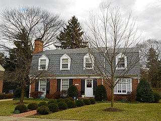
Tuscany-Canterbury is a historic neighborhood in northern Baltimore, Maryland, United States. Its history, development, and flavor are outlined in Eileen Higham's book Tuscany-Canterbury: A Baltimore Neighborhood History.

East Monument Historic District or Little Bohemia, is a national historic district in Baltimore, Maryland. It is a large residential area with a commercial strip along East Monument Street. It comprises approximately 88 whole and partial blocks. The residential area is composed primarily of rowhomes that were developed, beginning in the 1870s, as housing for Baltimore's growing Bohemian (Czech) immigrant community. During the late 19th and early 20th centuries the neighborhood was the heart of the Bohemian community in Baltimore. The Bohemian National Parish of the Roman Catholic Church, St. Wenceslaus, is located in the neighborhood. The historic district includes all of McElderry Park and Milton-Montford, most of Middle East and Madison-Eastend, and parts of Ellwood Park.

Hollins–Roundhouse Historic District is a national historic district in Baltimore, Maryland, United States. It is a primarily residential area characterized by 19th century rowhouses. The neighborhood is historically significant due to its association with the development of rail transportation in Maryland. Additional historical significance comes from the neighborhood's association with ethnic immigration to Baltimore. During the 1840s and 1850s the area was a center of settlement for Baltimore's German and Irish communities, many of whom immigrated to the United States to work in the rail industry. Later, from the 1880s to the 1920s, the neighborhood became established as the center of Baltimore's Lithuanian immigrant community. Because of the large Lithuanian population in the area north of Hollins Street, the area became known as Little Lithuania. A few remnants of the neighborhood's Lithuanian heritage still remain, such as Lithuanian Hall located on Hollins Street.


