
Brooklyn Park is a census-designated place (CDP) in Anne Arundel County, Maryland, United States. The population was 14,373 at the 2010 census.
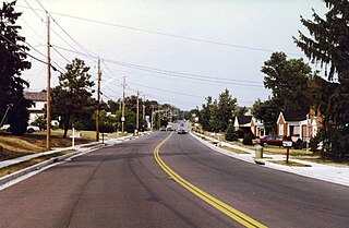
Carney is an unincorporated community and census-designated place in Baltimore County, Maryland, United States. The population was 29,941 at the 2010 census.
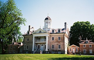
Hampton is an unincorporated community and census-designated place (CDP) in Baltimore County, Maryland, United States. The population was 5,052 at the 2010 census. Hampton is often considered a subdivision of the nearby community of Towson and is located just north of Baltimore, about twenty minutes from downtown. Hampton contains residences situated on lots up to several acres in a park-like setting. The community is anchored by its principal landmark, the Hampton National Historic Site. The Towson United Methodist Church is located in Hampton, flanked on the south by I-695 and Goucher College.

Towson is an unincorporated community and a census-designated place in Baltimore County, Maryland, United States. The population was 55,197 as of the 2010 census. It is the county seat of Baltimore County and the second-most populous unincorporated county seat in the United States.
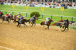
Pimlico is a neighborhood in Baltimore, Maryland. It is the site of Pimlico Race Course, which holds the Preakness Stakes, one of the three legs of the Triple Crown of Thoroughbred Racing. From 1896 through 1915, Pimlico was also the home of Baltimore's Electric Park, a popular amusement park located near the intersection of Reisterstown Road and Belvedere Avenue.

Ellwood Park is a neighborhood in the eastern part of Baltimore, Maryland. It is named for a small public park with a playground between Jefferson and Orleans Streets. The neighborhood extends from Linwood Avenue and Haven Street, between Monument Street and Fayette Street. It is contained within the 21205 and 21224 zip code.

Middle East is a neighborhood in the heart of East Baltimore, Maryland.
O'Donnell Heights is a neighborhood named for a public housing development in the far southeastern part of the city of Baltimore, Maryland, United States. It is located south and east of Interstate 95, just west of the border with Baltimore County, and north of the St. Helena neighborhood.
Loch Raven is a neighborhood extending from northeast Baltimore City to the eastern part of Baltimore County, Maryland. The major road in the neighborhood is Loch Raven Boulevard, which stretches all the way from the I-695 beltway in Baltimore County to 25th Street in Baltimore City. It is located in the Baltimore Metro Area, and is considered one of the longest roads in the area with many different aspects of Baltimore that can be seen by riding through the area. This region is a diverse, but predominantly African American part of the city and county, and is also the area that consists of a large amount of Morgan State University students. The zip codes assigned to this area are 21218, 21239, 21286, 21284, and 21234, which is also a Parkville zip code.

Edmondson Village is a neighborhood in the southwestern section of Baltimore, Maryland, encompassing most of the Edmondson Avenue corridor in 21229. The Edmondson Village area is made up of several smaller communities. Its communities include Hunting Ridge, Uplands, Rognel Heights, Wildwood, West Mulberry, Allendale, Edgewood, and Lower Edmondson Village. It is located north of Frederick Avenue, and south of the Gwynns Falls Parkway, Leakin and Gwynns Falls Parks. Communities in the area range from middle class to lower income. A notable shopping center opened in the neighborhood in 1947.

The Coldstream-Homestead-Montebello community, often abbreviated to C-H-M, is a neighbourhood in northeastern Baltimore, Maryland. A portion of the neighborhood has been listed on the National Register of Historic Places as the Coldstream Homestead Montebello Historic District, recognized for the development of a more suburban style of rowhouses.

Woodberry is a neighborhood located in the north-central area of Baltimore, Maryland, USA. A largely residential, middle-class area, Woodberry is a historic community bordered on the north by Cold Spring Lane, on the south by Druid Hill Park, on the west by Greenspring Avenue, and on the east by the Jones Falls Expressway and the Jones Falls. Woodberry is located within Postal Zip code 21211.

Hillen is a small community just west of Hillen Road and Morgan State University and south of Coldspring Lane in Baltimore, Maryland, United States.
Ramblewood is a small community located in northeast Baltimore, Maryland, United States. Ramblewood is located south of Northern Parkway with The Alameda serving as its western boundary and Loch Raven Blvd. as its eastern boundary and north of Belvedere Ave. The Ramblewood Community Association has had residential parking permits issued to its members as the result of the proliferation of students from Morgan parking in the neighborhood.
Keswick is a residential neighborhood in Baltimore, Maryland. The area is mostly surrounded by, and sometimes considered a part of, the Roland Park neighborhood. It also borders the Evergreen neighborhood to the north and Guilford to the east. Keswick is delineated as south of West Cold Spring Lane, east of Kittery Lane, north of Overhill Road, and west of Stony Run stream.
Perring-Loch is a small community located in northeast Baltimore, Maryland, United States. Perring Parkway serves as its eastern border and Loch Raven Boulevard as its western border; hence the name Perring-Loch. Woodbourne Avenue and Hartsdale Road are the northern and southern boundaries respectively. The entire community is with the 21239 postal zip code and is served by the Perring Loch community association.


