Related Research Articles

Catonsville is a census-designated place (CDP) in Baltimore County, Maryland, United States. The population was 41,567 at the 2010 census. The community lies to the west of Baltimore along the city's border. Catonsville contains the majority of the University of Maryland, Baltimore County (UMBC), a major public research university with close to 14,000 students.

Owings Mills is an unincorporated community and census-designated place in Baltimore County, Maryland, United States. It is a suburb of Baltimore. The population was 30,622 at the 2010 census. Owings Mills is home to the northern terminus of the Baltimore Metro Subway, and housed the Owings Mills Mall until its closure in 2015. It is also home to the Baltimore Ravens' headquarters facility, and the studios for Maryland Public Television. In 2008, CNNMoney.com named Owings Mills number 49 of the "100 Best Places to Live and Launch".

Pikesville is a census-designated place (CDP) in Baltimore County, Maryland, United States. Pikesville is just northwest of the Baltimore city limits. It is the northwestern suburb closest to Baltimore.

Timonium is a census-designated place (CDP) in Baltimore County, Maryland, United States. As of the 2010 census it had a population of 9,926. Prior to 2010 the area was part of the Lutherville-Timonium CDP. The Maryland State Fair is held in Timonium each year near Labor Day on the grounds of the former Timonium Race Course, which is an important site along with Pimlico Race Course in northwest Baltimore and Laurel Park in Prince George's County, along with other former tracks at Bowie and Rosecroft in Maryland thoroughbred horse racing traditions.
Ruxton and Riderwood are unincorporated communities in Baltimore County, Maryland, United States. They are sometimes considered a part of Towson and are part of Towson's census area.

Upton is a neighborhood in Baltimore City, Maryland, United States. The neighborhood is in the western section of the city, roughly between Fremont Avenue and McCulloh Street, extending from Dolphin Street to Bloom Street. Its principal thoroughfare is Pennsylvania Avenue.
Glen is a neighborhood in Baltimore, Maryland. It was developed in the early 1920s and 1930s, with the remaining development coming in the 1940s through the 1960s. Glen is one of the largest communities of Northern Park Heights in Baltimore. Glen is a neighborhood of mixed housing types that include Tudor, French Norman and brick ranch houses, along with garden apartments, condominiums and semi-detached single family homes.

Park Heights is an area of Baltimore City, Maryland, that lies approximately 10 miles northwest of downtown Baltimore and within two miles of the Baltimore County line. A 1,500-acre community, Park Heights comprises 12 smaller neighborhoods that together contain approximately 30,000 residents. It is bounded on the south by Druid Park Drive, on the west by Wabash Avenue, on the east by Greenspring Avenue, and on the north by Northern Parkway. Interstate-83 is less than a half mile to the east. Two major roadways—Park Heights Avenue and Reisterstown Road—run north-south through Park Heights, serving as the neighborhood's "Main Streets" as well as commuter corridors. Limited commercial uses—primarily retail—are scattered along these roads; there is also some industrial activity on the neighborhood's western edge.
Milford Mill Road, Slade Avenue, and Smith Avenue are a long road mostly in Baltimore County, Maryland that runs through Milford Mill and Pikesville in the suburbs of Baltimore. The road starts out at the light rail stop in historic Mt. Washington Village in Baltimore city as Smith Avenue, and continues through Pikesville up to Seven Mile Lane before its name changes to Slade Avenue, and the road widens to four lanes. The road is known as Slade Avenue until Reisterstown Road, and from there, its name becomes Milford Mill Road until it dead-ends one block south of Rolling Road in an area known as Windsor Mill. It is one of the most heavily used routes in the northwest suburbs of Baltimore, as it is used for cross-county travel by motorists between the Pikesville and Randallstown areas.
Northern Parkway is a major road that runs west–east across the northern part of the city Baltimore. For most of the way, it is at least six lanes wide, and it is used by motorists for crosstown travel. It is designated E. Northern Pkwy and W. Northern Pkwy with Charles Street being the dividing line. It was constructed in the 1950s through several neighborhoods and several homes were razed in the process from right-of-way. The section of E. Northern Pkwy from Harford Road to Fleetwood Ave was originally called German Lane.
Greenspring Avenue is a road in Baltimore, Maryland and its northwestern suburbs. At one time, Greenspring Avenue was Maryland Route 519 from Worthington Road to Dover Road, but the road has since been decommissioned and no longer has any numerical designation.

Forest Park is a region of Northwest Baltimore, Maryland located west of Reisterstown Road, south of Northern Parkway, and east of the Baltimore City/County line. In Baltimore, the region is referred to by locals simply as "Forest Park" and includes the neighborhoods of Ashburton, Callaway-Garrison, Central Forest Park, Dolfield, Dorchester, East Arlington, Forest Park, Grove Park, Hanlon Longwood, Howard Park, Garwyn Oaks, Purnell, West Arlington, West Forest Park, and Windsor Hills.

Windsor Mill Road is a road that runs through parts of Baltimore, Maryland and its western suburb Woodlawn. The road starts as a one-way street named Edgewood Street, then makes a slight left corner and becomes Windsor Mill Road. The road, which is approximately 7½ miles in length, runs parallel to nearby Liberty Road and Security Boulevard, and is often used as an alternative to these routes. Though Windsor Mill Road has no interchange with the Baltimore Beltway, it crosses over the highway, and this point is frequently mentioned in traffic reports.

Woodberry is a neighborhood located in the north-central area of Baltimore, Maryland, USA. A largely residential, middle-class area, Woodberry is a historic community bordered on the north by Cold Spring Lane, on the south by Druid Hill Park, on the west by Greenspring Avenue, and on the east by the Jones Falls Expressway and the Jones Falls. Woodberry is located within Postal Zip code 21211.
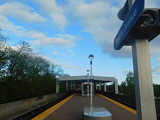
Rogers Avenue station is a Metro SubwayLink station in Baltimore, Maryland. It is located in the Arlington area, and is the fifth most northern and western station on the line, with approximately 900 parking spaces. It is a hub for several Maryland Transit Administration bus lines operating in various directions around the city, including routes:

Fallstaff is a neighborhood in the Upper Park Heights area of Northwest Baltimore, Maryland, and is one of the city's northwesternmost communities. The area, which is mostly middle class, is part of the center of Baltimore's Orthodox Jewish community, and also has a heavy African-American and immigrant population.
Wyndhurst is a neighborhood located in the North District of Baltimore, Maryland.

Route 58 is a bus route operated by the Maryland Transit Administration in Baltimore and its suburbs. The line's western terminus is the Reisterstown Plaza Metro Subway Station, and its eastern terminus is White Marsh Mall, though some peak hour trips make short turns in Overlea. Route 58 serves the communities of Glen, Cheswolde, Fallstaff, a large section of Northern Parkway, and a portion of Belair Road in Baltimore County.

The community of Wyman Park is a border community that links Hampden to Roland Park. All of the Wyman Park areas were annexed to Baltimore City in 1888. The general boundaries consist of the area from south to north between 33rd Street and 40th Streets and west to east from Keswick Road to Wyman Park. South of 40th Street, garden apartments, multi-story apartment buildings, and single-family residences have been built. People here tend to relate to the north along 40th Street and University Parkway and The Johns Hopkins University. The Wyman Park also accommodates the Union Soldiers and Sailors Monument, located at 29th and Charles Street, and the now removed Stonewall Jackson and Robert E. Lee Monument that has been rededicated as Harriet Tubman Grove on Art Museum Drive.

Jones Falls Trail is a hiking and bicycling trail in Baltimore, Maryland. It mostly runs along the length of the namesake Jones Falls, a major north–south stream in and north of the city that has long acted as a major transportation corridor for the city. It also incorporates the bike path encircling Druid Hill Reservoir and its namesake park. The Jones Falls Trail forms a segment of the East Coast Greenway, a partially completed network of off-road bicycling routes that runs the length of the East Coast.
References
- 1 2 3 Nancy Jones-Bonbrest (April 4, 1999). "Little-known, close-in charmer". Baltimore Sun. Retrieved 2010-09-18
- ↑ Sherrie Ruhl (September 25, 1994). "Jewish residents give haven vibrant identity". Baltimore Sun.