
Mount Vernon is a neighborhood immediately north of downtown Baltimore, Maryland. Designated a National Historic Landmark District and a city Cultural District, it is one of the city's oldest neighborhoods and originally was home to the city's wealthiest and most fashionable families. The name derives from the Mount Vernon home of George Washington; the original Washington Monument, a massive pillar commenced in 1815 to commemorate the first president of the United States, is the defining feature of the neighborhood.

Charles Village is a neighborhood located in the north-central area of Baltimore, Maryland, USA. It is a middle-class area with many single-family homes that is in proximity to many of Baltimore's urban amenities. The neighborhood began in 1869 when 50 acres (200,000 m2) of land were purchased for development. The land was divided and turned over to various builders who constructed home exteriors, leaving the interiors to be custom built according to buyer specifications. The area was first developed as a streetcar suburb in the early 20th century, and is thought to be the first community to employ tract housing tactics. At the time, the area was known as Peabody Heights; the moniker Charles Village, derived from Charles Street, the area's major north–south corridor, was coined in the 1970s as the beginning of a process of conceptually grouping a large and somewhat heterogeneous area. The neighborhood history has been researched and published by Gregory J. Alexander and Paul K. Williams in their book Charles Village: A Brief History.

Canton is a historic waterfront neighborhood in Baltimore, Maryland, United States. The neighborhood is along Baltimore's outer harbor in the southeastern section of the city, roughly two miles east of Baltimore's downtown district and next to or near the neighborhoods of Patterson Park, Fell's Point, Highlandtown, and Brewers Hill.

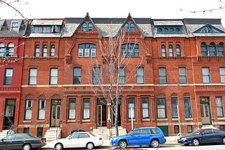
Bolton Hill is a neighborhood in Baltimore, Maryland, with 20 blocks of mostly preserved buildings from the late 19th century. It is listed on the National Register of Historic Places, preserved as a Baltimore City Historic District, and included within the boundaries of Baltimore National Heritage Area. The neighborhood is bounded by North Avenue, Mount Royal Avenue, Cathedral Street, Dolphin Street, and Eutaw Place. Bolton Hill is a largely residential neighborhood with three-story row houses with red brick, white marble steps, and high ceilings. There are also larger more ornate originally single-family houses, many houses of worship, parks, monuments, and a few large apartment buildings. Many significant residents have lived in the neighborhood, including F. Scott Fitzgerald, Woodrow Wilson, the Cone sisters, and Florence Rena Sabin.
The Station North Arts and Entertainment District is an area and official arts and entertainment district in the U.S. city of Baltimore, Maryland. The neighborhood is marked by a combination of artistically-leaning commercial ventures, such as theaters and museums, as well as formerly abandoned warehouses that have since been converted into loft-style living. It is roughly triangular, bounded on the north by 20th Street, on the east by Greenmount Avenue, and on the south and west by the tracks of Amtrak's Northeast Corridor, though the neighborhood's boundaries include a one-block wide extension over the tracks.

National Bohemian Beer, colloquially Natty Boh, is an American lager originating from Baltimore, Maryland. It was first brewed in 1885 by the National Brewing Company, but was eventually purchased by Pabst Brewing Company.

Highlandtown is a neighborhood of Baltimore, Maryland, United States.

The National Brewing Company was an American brewing company that was founded in Baltimore, Maryland, in 1885. Its Baltimore brewery was located between Dillon, Conkling and O'Donnell Streets in the city's Highlandtown neighborhood. After World War II, it grew to be the largest brewer in Baltimore and its advertising, including one-eyed mascot "Mr. Boh" and its slogan "From the Land of Pleasant Living", became part of the folk culture of the Baltimore area. In 1975, National Brewing Company was acquired by Carling O'Keefe. The combined firm, renamed Carling National Breweries, Inc., continued to operate the Highlandtown brewery until 1978, when it was closed and production moved to a nearby brewery in Halethorpe, Baltimore County that had been built by Carling in 1961. The National Brewing Company brands continued to be produced at the Halethorpe plant until 1996. Since 2001, the company’s two most prominent brands, National Bohemian Beer and Colt 45, have been brewed for Pabst Brewing Company at several breweries.

Kresson is a neighborhood of Southeast Baltimore, Maryland, United States.
The city of Baltimore, Maryland, has been a predominantly working-class town through much of its history with several surrounding affluent suburbs and, being found in a Mid-Atlantic state but south of the Mason-Dixon line, can lay claim to a blend of Northern and Southern American traditions.

Park Heights is an area of Baltimore City, Maryland, that lies approximately 10 miles northwest of downtown Baltimore and within two miles of the Baltimore County line. A 1,500-acre community, Park Heights comprises 12 smaller neighborhoods that together contain approximately 30,000 residents. It is bounded on the south by Druid Park Drive, on the west by Wabash Avenue, on the east by Greenspring Avenue, and on the north by Northern Parkway. Interstate-83 is less than a half mile to the east. Two major roadways—Park Heights Avenue and Reisterstown Road—run north-south through Park Heights, serving as the neighborhood's "Main Streets" as well as commuter corridors. Limited commercial uses—primarily retail—are scattered along these roads; there is also some industrial activity on the neighborhood's western edge.

Gunther Brewing Company is a historic brewery industrial building complex, located in the Canton neighborhood of southeast Baltimore, Maryland,. The site comprises 15 masonry buildings. The main structure is a five-story brick "L"-shaped Romanesque Revival-style brew house with a two-story brick ice plant built about 1910 and one- and two-story boiler room. Additional brew houses built in 1936 and 1950 are also on the property. The later Tulkoff factory and warehouse was built about 1964. It was home to the George Gunther, Jr. Brewing Company, founded in 1900. By 1959, it was the second largest brewery in Baltimore, one of the major centers of brewing in America, when it produced 800,000 barrels per year and employed approximately 600 people. Hamm's Brewing Company bought the Gunther Brewing Company in 1960, and later became part of Miller Brewing Company. Later the brand was acquired just three years later by the F. & M. Schaefer Brewing Company in 1963, the plant in Canton was closed in 1978. The Tulkoff company briefly used the factory for their sauce products at the conclusion of all brewing operations.

Baltimore East/South Clifton Park Historic District is a national historic district in Baltimore, Maryland, United States. It is primarily an urban residential area organized in a gridiron pattern. It comprises approximately 110 whole and partial blocks that formed the historic northeast corner of the City of Baltimore prior to 1888. While rowhouses dominate the urban area, the historic district also contains other property types which contribute to its character including brewing, meat packing, cigar manufacturing, printing, and a tobacco warehouse. The Baltimore Cemetery completes the historic district.

"Mount Winans" is a mixed-use residential, commercial and industrial neighborhood in the southwestern area of the City of Baltimore in Maryland. Its north, south and east boundaries are marked by the various lines of track of the CSX Railroad. In addition, Hollins Ferry Road running to the south towards suburban Baltimore County in the southwest and further connecting with adjacent Anne Arundel County to the southeast, draws its western boundary.
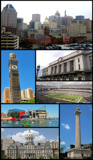
Baltimore is the most populous city in the U.S. state of Maryland, as well as the 30th most populous city in the United States, with an estimated population of 593,490 in 2019. Baltimore is the largest independent city in the country and was designated as such by the Constitution of Maryland in 1851. As of 2017, the population of the Baltimore metropolitan area was estimated to be just under 2.802 million, making it the 21st largest metropolitan area in the country. Baltimore is located about 40 miles (64 km) northeast of Washington, D.C., making it a principal city in the Washington–Baltimore combined statistical area (CSA), the fourth-largest CSA in the nation, with a calculated 2018 population of 9,797,063.

Patterson Park is a neighborhood in Baltimore, Maryland, United States. The neighborhood is located in the southeast section of Baltimore city and borders the 137 acre park of the same name on the north and east sides. Patterson Park is traditionally centered on the intersection of Baltimore Street and Linwood Avenue and until the formation of Patterson Park Neighborhood Association in 1986 was referred to as the Baltimore-Linwood Neighborhood. The original borders of Patterson Park neighborhood were Pratt Street to the south, Fayette Street to the north, Milton Street to the west and Clinton Street to the east, but in 2011 the Patterson Park Neighborhood Association voted to expand the northern border to Orleans Street between Milton and Curley Street.
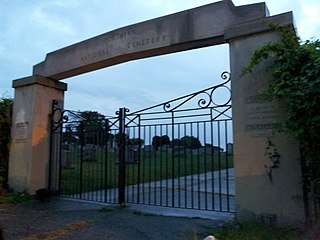
Bohemian National Cemetery, also known as Oak Hill Cemetery, is a cemetery located at 1300 Horners Lane, Armistead Gardens in East Baltimore, Maryland.

Baltimore Bohemians were an American soccer club based in Baltimore. They competed in the USL Premier Development League, the fourth tier of the American Soccer Pyramid, between 2012 and 2016. The club went on hiatus for the 2017 season.

East Monument Historic District or Little Bohemia, is a national historic district in Baltimore, Maryland. It is a large residential area with a commercial strip along East Monument Street. It comprises approximately 88 whole and partial blocks. The residential area is composed primarily of rowhomes that were developed, beginning in the 1870s, as housing for Baltimore's growing Bohemian (Czech) immigrant community. During the late 19th and early 20th centuries the neighborhood was the heart of the Bohemian community in Baltimore. The Bohemian National Parish of the Roman Catholic Church, St. Wenceslaus, is located in the neighborhood. The historic district includes all of McElderry Park and Milton-Montford, most of Middle East and Madison-Eastend, and parts of Ellwood Park.
Venice Tavern is a dive bar in the Highlandtown neighborhood of Baltimore, Maryland. The bar opened in 1933, when Frank Sr and Victoria DeSantis converted their basement and added an exterior staircase to access it from outside of their Conkling Street row house. The 3-story mansion above the bar was originally built in 1920 for William Schluderberg of C., a member of the William Schluderberg & Son meat packing family, and now houses a local and organic farmers market store.


