Roland Park, Baltimore

Last updated
Roland Park Historic District
Roland Park, Baltimore
LocationIrregular pattern between Belvedere Ave., Falls Rd., 39th St., and Stoney Run, Baltimore, Maryland
Coordinates 39°20′57″N76°38′05″W / 39.34917°N 76.63472°W / 39.34917; -76.63472
Area700 acres (280 ha)
Built1890 (1890)
ArchitectOlmsted, Frederick Law; Et al.
Architectural styleLate 19th And 20th Century Revivals, Late Victorian
NRHP reference No. 74002213 [1]
Added to NRHPDecember 23, 1974

Roland Park is a community located in Baltimore, Maryland. It was developed between 1890 and 1920 as an upper-class streetcar suburb. The early phases of the neighborhood were designed by Edward Bouton and Frederick Law Olmsted Jr.

Contents

History

Roland Park plan Roland Park Proposed Plan 1908.jpg
Roland Park plan

Jarvis and Conklin, a Chicago investment firm, purchased 500 acres (200 ha) of land near Lake Roland in 1891 and founded the Roland Park Company with $1 million in capital. Not long after, the Panic of 1893 forced Jarvis and Conklin to sell the Roland Park Company to the firm of Stewart and Young. Despite the dire economics after 1893, Stewart and Young continued investment in the development. [2] [3]

The Roland Park Company hired Kansas City developer Edward H. Bouton as the general manager and George Edward Kessler to lay out the lots for the first tract. They hired the Olmsted Brothers to lay out the second tract, and installed expensive infrastructure, including graded-streets, gutters, sidewalks, and constructed the Lake Roland Elevated Railroad. The company consulted George E Waring Jr. to advise them on the installation of a sewer system. Bouton placed restrictive covenants on all lots in Roland Park. These included setback requirements and proscriptions against any business operations. [4]

It was a modern development, electricity for lighting throughout the neighborhood as well as gas for cooking and lighting. Water came from artesian wells dug up to 500 feet (150 m), nearly 50,000 feet (15,000 m) of water mains were constructed, in addition to 50,000 feet (15,000 m) of roadways, and 100,000 feet (30,000 m) of sidewalks. [5]

Bouton and some Baltimore investors purchased the interests of Roland Park and reorganized the company in 1903. [6]

Frederick Law Olmsted Jr. cited Roland Park as a model residential subdivision to his Harvard School of Design students. Duncan McDuffie, developer of St. Francis Wood in San Francisco, called Roland Park "an ideal residential district." Jesse Clyde Nichols had found inspiration in Roland Park when he was planning the Country Club District of Kansas City. [7] Nichols continued to refer to Roland Park as an ideal residential development when he counselled other residential developers. [8] The park-like setting designed by the Olmsted brothers was a mark of affluence echoed by other neighborhoods in Baltimore such as Mayfield and Guilford. [9]

Deed restrictions and further implications

In the late 1800s and early 1900s, Baltimore saw an influx of immigrants, nearing 600,000. Bouton took 100 acres of land a few miles north of Downtown Baltimore and sold it as an exclusive, lush “garden suburb”, free of city grime and racial diversity. [10]

Letters from the time show that Bouton asked a law firm, Schmuker & Whitelock, if he could legally restrict who bought property in Roland Park. Though the firm advised against it, by 1912, the ‘Nuisances’ section of the deed read, “At no time shall the land included in said tract or any part thereof, or any building erected thereon, be occupied by any negro or person of negro extraction. This prohibition, however, is not intended to include occupancy by a negro domestic servant.” [10]

Additionally, Bouton claimed that he did not sell to Jews, as they were “undesirable”, at the 1914 Annual Conference of the Development of High-Class Residential Property, further demonstrating the levels of exclusion in the emerging city suburbs. [10]

In 1911, George Ford, a professor at Columbia University and later the president of the National Conference on City Planning, was starting to teach a course on urban planning and reached out to Bouton as he was impressed with his racial restrictions. Employees of the Roland Park Company would later go on to serve on national boards, such as the Federal Housing Administration, which helped normalize and standardize the practice of redlining throughout the country. [10]

Though the Supreme Court ruled against the enforceability of racially restrictive deeds in 1948, segregation and redlining remained prevalent in Roland Park and throughout other areas of Baltimore City through the 1950s and up until today. In the early 1940s and ‘50s, Baltimore City and the federal government undertook housing development projects displacing African-American populations into inner-city, high-rise buildings that were, essentially, created to reinforce the patterns of neighborhood segregation that emerged in the late 1800s. On this matter, the government stated the project was “not [for] slum clearance but rather using the projects to block the Negro from encroaching upon white territory”. [11]

The real estate developer James W. Rouse used antisemitic quotas when building in Roland Park. In 1951, Rouse enforced a quota of no more than 12% Jewish residents for the Maryland Apartment in north Baltimore until 75% of the apartments were rented. [12] [13]

Roland Park Shopping Center

Roland Park Shopping Center 1907 or shortly thereafter Roland Park Shopping Center.jpg
Roland Park Shopping Center 1907 or shortly thereafter

Roland Park Shopping Center (originally Roland Park Business Block) [14] was built at the corner of Upland Road and Roland Avenue in 1896 in the English Tudor style. Developed by Roland Park Company President Edward Bouton and designed by Wyatt and Nolting, it was originally planned as an apartment and office building with a “community room” for civic functions on the upper level. [15]

It opened in 1907 as shops. [16] [17] [18] It has been credited by Guinness World Records as the world's first shopping center (though some editions of Guinness incorrectly date it to 1896, when it was not yet a shopping center). Since it had only six stores, qualifying today as a strip mall, other, larger centers have received more recognition as “firsts”, such as Market Square in Lake Forest, Illinois (1916, the first uniformly planned neighborhood shopping center) and the Country Club Plaza (1923) in Kansas City, Missouri, the first uniformly-planned regional shopping center. [19] [20] [21]

Education

The neighborhood is within the bounds of Baltimore City Public Schools and is assigned to Roland Park Elementary/Middle School, [22] a K-8 school [23] that earned the Blue Ribbon for Academic Excellence from the state department of education in 1997 and 1998.

There are several private schools in the neighborhood: Friends School of Baltimore, Gilman School, Roland Park Country School, the Bryn Mawr School, Cathedral School, and Boys' Latin School of Maryland. In addition, St. Mary's Seminary and University is located in Roland Park.

There is also a branch of the Enoch Pratt Free Library in Roland Park.

Transportation

The Baltimore Light Rail's Cold Spring Lane Station is to the west, within walking distance of much of the neighborhood, just across Falls Road and running alongside the Jones Falls Expressway.

Related Research Articles

<span class="mw-page-title-main">Columbia, Maryland</span> Planned community

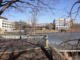
Columbia is a census-designated place in Howard County, Maryland, United States. It is a planned community consisting of 10 self-contained villages. The census-designated place had a population of 104,681 at the 2020 census, making it the second most populous community in Maryland after Baltimore. Columbia, located between Baltimore and Washington, D.C., is officially part of the Baltimore metropolitan area.

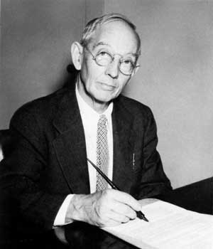
James Wilson Rouse was an American businessman and founder of The Rouse Company. Rouse was a pioneering American real estate developer, urban planner, civic activist, and later, free enterprise-based philanthropist. He received the Presidential Medal of Freedom, the highest civilian award, for his lifetime achievements.

<span class="mw-page-title-main">Palos Verdes Estates, California</span> City in California, United States

Palos Verdes Estates is a city in Los Angeles County, California, United States, situated on the Palos Verdes Peninsula. The city was master-planned by the noted American landscape architect and planner Frederick Law Olmsted Jr. The city is located along the Southern California coastline of the Pacific Ocean.

<span class="mw-page-title-main">Palos Verdes Peninsula</span> Sub-region of the Los Angeles metropolitan area in California, United States

The Palos Verdes Peninsula is a peninsula and sub-region of the Los Angeles metropolitan area, located within southwestern Los Angeles County in the U.S. state of California. Located in the South Bay region, the peninsula contains a group of cities in the Palos Verdes Hills, including Palos Verdes Estates, Rancho Palos Verdes, Rolling Hills and Rolling Hills Estates, as well as the unincorporated community of Westfield/Academy Hill. The South Bay city of Torrance borders the peninsula on the north, the Pacific Ocean is on the west and south, and the Port of Los Angeles is east. As of the 2010 Census, the population of the Palos Verdes Peninsula is 65,008.

<span class="mw-page-title-main">Wilde Lake, Columbia, Maryland</span> Village in Maryland, United States

Wilde Lake is a man-made drainage reservoir dug in 1966 and also named after the surrounding "village" of neighborhoods located in Columbia, Maryland, just north and west of Columbia Town Center. The village was the first part of Columbia's "New Town" to be built in the late 1960s, James W. Rouse and Frazar B. Wilde formally opened the neighborhood on June 21, 1967. The lake and village are named for Frazar B. Wilde, a past chairman of the board of Connecticut General Life Insurance Company and former employer of James Rouse. In 1963, the company agreed to fund the secret land purchases and, in return, acquired an equity participation. This arrangement was subsequently formalized by the creation of The Howard Research and Development Corporation, the joint venture established to develop Columbia.

<span class="mw-page-title-main">The Rouse Company</span> American real estate development company

The Rouse Company, founded by Hunter Moss and James W. Rouse in 1939, was a publicly held shopping mall and community developer from 1956 until 2004, when General Growth Properties (GGP) purchased the company.

<span class="mw-page-title-main">River Hill, Columbia, Maryland</span> Village in Maryland, United States

River Hill is the last and westernmost village to be developed in the town of Columbia, Maryland, United States, though some residents maintain addresses in Clarksville. The village is home to 6,520 residents in 2,096 housing units in 2014. The area was used as a game preserve by James Rouse to entertain clients and personal hunting during the buildout of the Columbia project. In 1976, County Executive Edward L. Cochran selected the 784-acre parcel owned by Howard Research and Development for an alternate location for a county landfill; a task force selected Alpha Ridge Landfill instead. Residential construction started in 1990. It is bounded by Maryland Route 108 and Maryland Route 32, and is centered on Trotter Road. The village is divided into two neighborhoods: Pheasant Ridge and Pointers Run, with about 6,500 residents.

<span class="mw-page-title-main">Kings Contrivance, Columbia, Maryland</span> Village in Maryland, United States

Kings Contrivance is a village in the planned community of Columbia, Maryland, United States and is home to approximately 11,000 residents. It is Columbia's southernmost village, and was the eighth of Columbia's ten villages to be developed. Kings Contrivance consists of the neighborhoods of Macgill's Common, Huntington and Dickinson, and includes single-family homes, townhouses, apartments and a Village Center.

<span class="mw-page-title-main">Hampden, Baltimore</span> Neighborhood of Baltimore in Maryland, United States

Hampden is a neighborhood located in northern Baltimore, Maryland, United States. Roughly triangular in shape, it is bounded to the east by the neighborhood Wyman Park, to the north by Roland Park at 40th and 41st Street, to the west by the Jones Falls Expressway, and to the south by the neighborhood Remington. The Homewood campus of the Johns Hopkins University is a short distance to the east.

<span class="mw-page-title-main">Long Reach, Columbia, Maryland</span> Village in Maryland, United States

Long Reach, one of ten villages composing Columbia, Maryland, United States, is found in the northeast part of Columbia along Maryland Route 108. Started in 1971, it is one of the oldest villages, and comprises four neighborhoods: Jeffers Hill, Kendall Ridge, Locust Park, and Phelps Luck. The village, with an approximate population of 15,600, is governed by five elected village board members through "Long Reach Community Association, Inc." The Village Office is located in Stonehouse, the community center, which opened in 1974.

<span class="mw-page-title-main">Frederick Law Olmsted Jr.</span> American landscape architect; not to be confused with his father, who designed Central Park

Frederick Law Olmsted Jr. was an American landscape architect and city planner known for his wildlife conservation efforts. He had a lifetime commitment to national parks, and worked on projects in Acadia, the Everglades and Yosemite National Park. He gained national recognition by filling in for his father on the Park Improvement Commission for the District of Columbia beginning in 1901, and by contributing to the famous McMillan Commission Plan for redesigning Washington according to a revised version of the original L’Enfant plan. Olmsted Point in Yosemite and Olmsted Island at Great Falls of the Potomac River in Maryland are named after him.

<span class="mw-page-title-main">Gibson Island (Maryland)</span> Unincorporated community in Maryland, United States

Gibson Island is an island and unincorporated community on the western shore of the Chesapeake Bay. It is part of Anne Arundel County, Maryland, United States and is the eastern terminus of Maryland Route 177. It is connected by a causeway to Pasadena, Maryland. The two locations do not share a ZIP code.

<span class="mw-page-title-main">Village of Cross Keys</span> Planned community in Maryland, United States

Village of Cross Keys is a privately owned upscale area of Baltimore, Maryland. It is located off Maryland Route 25 between Northern Parkway and Cold Spring Lane, and is home to luxury condos and upscale small shops.

<span class="mw-page-title-main">Harper's Choice, Columbia, Maryland</span> Village in Maryland, United States

Harper's Choice is one of the ten villages that comprise Columbia, Maryland, United States. It lies in the northwest part of Columbia and consists of the neighborhoods of Longfellow, Swansfield, and Hobbit's Glen and had a December 1998 population of 8,695.

<span class="mw-page-title-main">Medfield, Baltimore</span> Neighborhood of Baltimore in Maryland, United States

Medfield is a neighborhood located in north Baltimore, Maryland, United States of America. It is located to the north of the trendy Hampden neighborhood and south of affluent Roland Park neighborhood. Its unofficial boundaries are Coldspring Lane to the north; Jones Falls Expressway to the west; Falls Road/Hickory Avenue to the east; and West 41st Street to the south.

<span class="mw-page-title-main">Guilford, Baltimore</span> United States historic place

Guilford is a prominent and historic neighborhood located in the northern part of Baltimore, Maryland. It is bounded on the south by University Parkway, on the west by North Charles Street, Warrenton and Linkwood Roads, on the north by Cold Spring Lane and on the east by York Road. The neighborhood is adjacent to the neighborhoods of Tuscany-Canterbury, Loyola-Notre Dame, Kernewood, Wilson Park, Pen Lucy, Waverly Oakenshawe, Charles Village, and the universities of Johns Hopkins and Loyola University Maryland. The neighborhood was added to the National Register of Historic Places in 2001.

<span class="mw-page-title-main">Wyndhurst, Baltimore</span> Neighborhood of Baltimore in Maryland, United States

Wyndhurst is a neighborhood located in the North District of Baltimore, Maryland.

<span class="mw-page-title-main">Lake Roland (park)</span> United States historic place

Lake Roland is a city/county park encompassing over 500 acres of woodland, wetlands, serpentine barrens, rare plants and rocky plateaus surrounding Lake Roland in Baltimore County, Maryland. The park is located near the intersection of Falls Road and Lake Avenue, adjacent to the Falls Road Light Rail Stop of the Baltimore Light Rail, which runs from Cromwell Station near Glen Burnie in Anne Arundel County in the south to Hunt Valley of Baltimore County. The line runs along a railroad embankment and trestle over the lake above the dam, cutting the park into a two-thirds wooded northern part and the one-third southern portion around the dam, picnic groves, pavilion and pumping station.

Guy T. O. Hollyday (1893–1991) was an American proponent of urban housing renewal.

The history of Antisemitism in Maryland dates to the establishment of the Province of Maryland. Until 1826, the Constitution of Maryland excluded Jewish people from holding public office. Prior to the passage of the 1968 Fair Housing Act, Jewish people were excluded from living in many white Christian neighborhoods throughout Maryland due to the use of restrictive covenants and quotas. Between the 1930s and 1950s, quota systems were instituted at universities in Maryland to limit the number of Jewish people. During the 2010s and 2020s, Maryland has seen an increase in reported incidents of antisemitic vandalism and violence.

References

Baltimore Country Club, in Roland Park BCCRolandPark.jpg
Baltimore Country Club, in Roland Park
  1. "National Register Information System". National Register of Historic Places . National Park Service. July 9, 2010.
  2. Robert M. Fogelson (2005). Bourgeois Nightmares: suburbia, 1870-1930, p.59-60.
  3. Catharine F. Black (November 1973). "National Register of Historic Places Registration: Roland Park Historic District" (PDF). Maryland Historical Trust. Retrieved 2016-03-01.
  4. Robert M. Fogelson (2005). Bourgeois Nightmares: suburbia, 1870-1930, p.60-63, 66-67.
  5. Tom (2013-09-23). "History of Roland Park". Ghosts of Baltimore. Retrieved 2019-02-19.
  6. Robert M. Fogelson (2005). Bourgeois Nightmares: suburbia, 1870-1930, p.64.
  7. Robert M. Fogelson (2005). Bourgeois Nightmares: suburbia, 1870-1930, p.63.
  8. Cheryl Caldwell Ferguson (Oct 2000). "River Oaks:1920s Suburban Planning and Development in Houston". Southwestern Historical Quarterly 104, p.121.
  9. "Historic Architecture – Mayfield" . Retrieved 2023-03-07.
  10. 1 2 3 4 Fall 2014, Elizabeth Evitts Dickinson / Published (2014-09-10). "Roland Park: one of America's first garden suburbs, and built for whites only". The Hub. Retrieved 2021-03-24.
  11. Gladora, Chris (2006). "History: Housing Policy and Segregation in Baltimore". Indypendent Reader. Archived from the original on 2020-04-12. Retrieved 2021-03-24.
  12. Glotzer, Paige (2020). How the Suburbs Were Segregated: Developers and the Business of Exclusionary Housing, 1890-1960. New York: Columbia University Press. ISBN   9780231542494.
  13. "New book on segregation and bigotry holds up a harsh mirror to Baltimore". Baltimore Brew . Retrieved 2022-04-26.
  14. "How Roland Park Was Founded and Developed". Baltimore Sun. December 27, 1908.
  15. "Roland Park Welcomes You". rolandparkhistory.org.
  16. Wallach, Bret (2005). Understanding the Cultural Landscape. Guilford Publications. p. 320. ISBN   9781593851194.
  17. Borden, Iain (2004). The City Cultures Reader. Routledge. p. 161. ISBN   9780415302456.
  18. Scharoun, Llisa (2012). American at the Mall. McFarland. p. 7. ISBN   9780786490509.
  19. Rybczynski, Witold. City Life p.204 (Scribner 1996) ( ISBN   978-0684825298)
  20. Urban Land Institute, The community builders handbook p. 125 (1954)
  21. Marx, Paul. Jim Rouse: capitalist/idealist , p.111 (2007) ( ISBN   978-0761839446) ("...it has a small cluster of shops near its center. That group of shops is generally considered to be the very first shopping center in America.")
  22. "Elementary/K-8 Schools and Attendance Zones School Year 2014-15" and "Elementary/K-8 Schools and Attendance Zones School Year 2015-16" in: Appendix C." Baltimore City Public Schools. The 2014-2015 map is on p. 120 (PDF p. 10/34) and the 2015-2016 map is on p. 122 (PDF p. 12/34). Retrieved on July 10, 2016. Roland Park is no. 233 on both maps.
  23. Roland Park Public School http://rolandparkpublic.org/?page_id=2