Related Research Articles

Loyola University Maryland is a private Jesuit liberal arts university in Baltimore, Maryland. Established as Loyola College in Maryland by John Early and eight other members of the Society of Jesus in 1852, it is one of 27 member institutions of the Association of Jesuit Colleges and Universities, the ninth-oldest Jesuit college in the United States, and the first college in the United States to bear the name of St. Ignatius of Loyola, the founder of the Society of Jesus.
Notre Dame of Maryland University is a private Catholic university in Baltimore, Maryland. NDMU offers Maryland’s only women’s college, as well as certificate, undergraduate, graduate, and Ph.D. programs for women and men.
Ruxton and Riderwood are unincorporated communities in Baltimore County, Maryland, United States. They are sometimes considered a part of Towson and are part of Towson's census area.
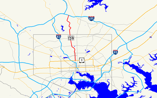
Charles Street, known for most of its route as Maryland Route 139, runs through Baltimore City and through the Towson area of Baltimore County. On the north end it terminates at an intersection with Bellona Avenue near Interstate 695 (I-695) and at the south end it terminates in Federal Hill in Baltimore. Charles Street is one of the major routes through the city of Baltimore, and is a major public transportation corridor. For the one-way portions of Charles Street, the street is functionally complemented by the parallel St. Paul Street, Maryland Avenue, Cathedral Street, and Liberty Street.
Northern Parkway is a major road that runs west–east across the northern part of the city Baltimore. For most of the way, it is at least six lanes wide, and it is used by motorists for crosstown travel. It is designated E. Northern Pkwy and W. Northern Pkwy with Charles Street being the dividing line. It was constructed in the 1950s through several neighborhoods and several homes were razed in the process from right-of-way. The section of E. Northern Pkwy from Harford Road to Fleetwood Ave was originally called German Lane.
St. Paul Street and Calvert Street are a one-way pair of streets in Downtown Baltimore and areas north. The streets, which are part of Maryland Route 2, are two of Baltimore's best-known streets in the downtown area.

Woodberry is a neighborhood located in the north-central area of Baltimore, Maryland, USA. A largely residential, middle-class area, Woodberry is a historic community bordered on the north by Cold Spring Lane, on the south by Druid Hill Park, on the west by Greenspring Avenue, and on the east by the Jones Falls Expressway and the Jones Falls. Woodberry is located within Postal Zip code 21211.

Radnor-Winston is a small community centered near the intersection of York Road and Winston Ave in the North District of Baltimore. Radnor Winston is a friendly, affordable and diverse neighborhood of about 220 homes tucked behind the campuses of Loyola University and The College of Notre Dame. Located in the Roland Park Public School district, the neighborhood is convenient to both downtown Baltimore and Towson.

Medfield is a neighborhood located in north Baltimore, Maryland, United States of America. It is located to the north of the trendy Hampden neighborhood and south of affluent Roland Park neighborhood. Its unofficial boundaries are Coldspring Lane to the north; Jones Falls Expressway to the west; Falls Road/Hickory Avenue to the east; and West 41st Street to the south.
Guilford is a prominent and historic neighborhood located in the northern part of Baltimore, Maryland. It is bounded on the south by University Parkway, on the west by North Charles Street, Warrenton and Linkwood Roads, on the north by Cold Spring Lane and on the east by York Road. The neighborhood is adjacent to the neighborhoods of Tuscany-Canterbury, Loyola-Notre Dame, Kernewood, Wilson Park, Pen Lucy, Waverly Oakenshawe, Charles Village, and the universities of Johns Hopkins and Loyola University Maryland. The neighborhood was added to the National Register of Historic Places in 2001.
Mid-Govans is a community in northeast Baltimore, Maryland and part of the development of York Road, a historic Baltimore route to Pennsylvania. As the name suggests, Mid-Govans is located in the center of the larger neighborhood, Govans, with the rough boundaries of York Road to the west, Belvedere Avenue to the north, Midwood Avenue to the east, and Woodbourne Avenue to the south.

Maryland House of Delegates District 43 is one of 47 legislative districts in the state of Maryland and one of the 5 located entirely within Baltimore City. Voters in this district select three Delegates every four years to represent them in the Maryland House of Delegates.
The neighborhoods of Abell, Cedarcroft, Charles Village, Coldstream-Homestead-Montebello, Ednor Gardens-Lakeside, Guilford, Homeland, Hillen, Lake Evesham, Lauraville, Mid-Govans, Northwood, Pen Lucy, Radnor-Winston, Ramblewood, Stonewood-Pentwood-Winston, Tuscany-Canterbury, Waverly, Wilson Park and Woodbourne Heights, Baltimore make up the majority of the district.
Evergreen is a neighborhood in the North District of Baltimore, Maryland. Evergreen's buildings date from the late 19th to early 20th century. It is known as one of the first early non-rowhouse styled suburban communities in Baltimore.
Keswick is a residential neighborhood in Baltimore, Maryland. The area is mostly surrounded by, and sometimes considered a part of, the Roland Park neighborhood. It also borders the Evergreen neighborhood to the north and Guilford to the east. Keswick is delineated as south of West Cold Spring Lane, east of Kittery Lane, north of Overhill Road, and west of Stony Run stream.

The community of Wyman Park is a border community that links Hampden to Roland Park. All of the Wyman Park areas were annexed to Baltimore City in 1888. The general boundaries consist of the area from south to north between 33rd Street and 40th Streets and west to east from Keswick Road to Wyman Park. South of 40th Street, garden apartments, multi-story apartment buildings, and single-family residences have been built. People here tend to relate to the north along 40th Street and University Parkway and The Johns Hopkins University. The Wyman Park also accommodates the Union Soldiers and Sailors Monument, located at 29th and Charles Street, and the now removed Stonewall Jackson and Robert E. Lee Monument that has been rededicated as Harriet Tubman Grove on Art Museum Drive.
Remington is a neighborhood in northern Baltimore bordered to the north by Hampden, Wyman Park, and Johns Hopkins University and to the east by Charles Village. The southernmost boundary is North Avenue and the long southwestern boundary is formed by Falls Road in the I-83 corridor. The neighborhood is split between two Baltimore City Council Districts.
The Orchards is a neighborhood in the North District of Baltimore, located between the neighborhoods of New North Roland Park–Poplar Hill and Bellona–Gittings. Its boundaries are marked by the Baltimore County line (north), Maryland Route 133 Northern Parkway (south), and Maryland Route 139 Charles Street (east). Roland Avenue, West Lake Avenue, Kenmore Road and Melrose Avenue draw the neighborhood's west boundary.

Harwood is a small neighborhood located in the north-central area of Baltimore, Maryland, USA. It sits east of Charles Village, south of Abell, west of Waverly and north of Barclay. Its boundaries are Guilford and Greenmount Avenues to the east and west, and 25th and 29th streets to the north and south. These streets together encompass about 14 city blocks.
Govans is a neighborhood located in north
Baltimore, Maryland. It includes the communities of Mid-Govans, Rosebank, Lothian, Benninghause, Woodbourne McCabe, Winston-Govans, Homeland, and Richnor Springs.
References
- ↑ "Loyola (Notre Dame) neighborhood in Baltimore, Maryland (MD), 21212, 21210 detailed profile". city-data.com. January 19, 2014.
Coordinates: 39°21′05″N76°36′58″W / 39.35149°N 76.6161°W
| This Baltimore location article is a stub. You can help Wikipedia by expanding it. |