Overlea is a neighborhood in northeast Baltimore. It is home to the Maryland School for the Blind. [1]
Overlea | |
|---|---|
| Country | |
| State | |
| City | |
| Time zone | UTC−5 (Eastern) |
| • Summer (DST) | UTC−4 (EDT) |
| Area Codes | 410, 443, 667 |
Overlea is a neighborhood in northeast Baltimore. It is home to the Maryland School for the Blind. [1]
Overlea | |
|---|---|
| Country | |
| State | |
| City | |
| Time zone | UTC−5 (Eastern) |
| • Summer (DST) | UTC−4 (EDT) |
| Area Codes | 410, 443, 667 |
In 1919, part of the community of Overlea in Baltimore County was annexed by the city of Baltimore. [2]

Severna Park is a census-designated place (CDP) in Anne Arundel County, Maryland, United States. Severna Park is part of the Baltimore-Washington Metropolitan Area, and is located approximately 8 miles (13 km) north of Annapolis, 17 miles (27 km) south of Baltimore and 39 miles (63 km) east of Washington. Severna Park's population was 37,634 at the 2010 census.

Arbutus is an unincorporated community and a census-designated place in Baltimore County, Maryland, United States. The population was 20,483 at the 2010 census. The census area also contains the communities of Halethorpe and Relay, in which all three names were used during the 1960 census when the area had a population of 22,402.

Overlea is an unincorporated community and census-designated place in Baltimore County, Maryland, United States. The population was 12,275 at the 2010 census. Students attend Overlea High School. Area roads include Belair Road and Kenwood Avenue.

Cherry Hill is one of the southernmost neighborhoods in Baltimore, Maryland.

Kresson is a neighborhood of Southeast Baltimore, Maryland, United States.

Forest Park is a region of Northwest Baltimore, Maryland located west of Reisterstown Road, south of Northern Parkway, and east of the Baltimore City/County line. In Baltimore, the region is referred to by locals simply as "Forest Park" and includes the neighborhoods of Ashburton, Callaway-Garrison, Central Forest Park, Dolfield, Dorchester, East Arlington, Forest Park, Grove Park, Hanlon Longwood, Howard Park, Garwyn Oaks, Purnell, West Arlington, West Forest Park, and Windsor Hills.

Parkville High School (PHS) is a four-year public high school in Baltimore County, Maryland, United States. The school was originally established in 1953 on what is now the location of Parkville Middle School. The current high school building opened in 1961. Area middle schools include Parkville Middle, Loch Raven Academy, and Pine Grove Middle.

East Baltimore Midway is a neighborhood in the Eastern district of Baltimore, Maryland. Its boundaries are the south side of 25th Street, the east side of Greenmount Avenue, the west side of Harford Road, and the north side of North Avenue.

Fullerton is an unincorporated community in Baltimore County, Maryland, United States. The area is often considered part of Nottingham, despite being part of Overlea. Fullerton residents have either 21236 or 21206 as their ZIP code.
Keswick is a residential neighborhood in Baltimore, Maryland. The area is mostly surrounded by, and sometimes considered a part of, the Roland Park neighborhood. It also borders the Evergreen neighborhood to the north and Guilford to the east. Keswick is delineated as south of West Cold Spring Lane, east of Kittery Lane, north of Overhill Road, and west of Stony Run stream.
The Rotunda is a mixed-use property in northern Baltimore, Maryland in the popular neighborhood of Hampden, adjacent to the neighborhoods of Roland Park, and Wyman Park and near the campus of the Johns Hopkins University. The property features retail, office, and residential components including: 150,000 ft² of retail space, 140,000 ft² of office space, 379 apartments and over 1100 off-street parking spaces, including a multi-level parking garage featuring several electric car charging stations.
Lakeland is a neighborhood in south Baltimore, Maryland. Its borders are Annapolis Road on the east, the Baltimore city/county line to the south, a CSX/MARC Railroad line to the west, and the same railroad line to the north.
Waltherson is a neighborhood located in Northeast Baltimore, Maryland, United States that runs between Harford Road to Belair Road and from Hamilton Ave in the north and Southern Ave in the south. It was later expanded to include the neighborhood of Wilson Heights extending its boundaries along Belair Road to Moravia Road to achieve the boundaries currently seen on Baltimore City's CityView page.
Taylor Heights is a neighborhood in northeast Baltimore. The neighborhood contains only a few homes because Parkwood Cemetery takes up much of the neighborhood. A major road in the neighborhood is Taylor Avenue, which runs from Overlea in the east to Towson in the west, at which point it becomes Goucher Boulevard/Hillen Road.

Gwynn's Falls is a neighborhood in the Southwestern District of Baltimore, located between Irvington (west) and Gwynns Falls Leakin Park (east). Frederick Avenue marks the neighborhood's boundary to the north; Wilkens Avenue draws its southern edge. Caton Avenue separates it from Irvington to the west.

The Baltimore City Archives is the official municipal archive of the City of Baltimore, Maryland. The archive is located on Mathews Street in the Better Waverly, Baltimore neighborhood. The Baltimore City Archives "is the central depository for government records of permanent value."
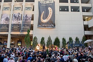
Horseshoe Baltimore is an urban two-story casino, and the second largest casino in Maryland with a 122,000-square-foot gaming floor. The multimillion-dollar facility features video lottery terminals, table games, and a World Series of Poker room. Horseshoe's 20,000-square-foot Baltimore Marketplace features Charm City food outlets, three premier restaurants, and several bars and lounges.

Loyola-Notre Dame is a neighborhood located in Baltimore, Maryland. The neighborhood is named after the two universities that occupy most of the area: Notre Dame of Maryland University and Loyola University Maryland. The neighborhood is also home to the Evergreen House owned by Johns Hopkins University. The neighborhood covers all the area owned by the two universities and Evergreen House. The neighborhood does not cover a uniform area, but does have a relative definition. The northern boundary is Homeland Avenue. The eastern boundary varies among Millbrook Road, Underwood Road and other small streets. The Radnor Village, Thomas Aquinas Hall, and Loyola Public system are also included in the neighborhood despite being separated from the rest of the Loyola campus by the Radnor-Winston and Villages of Homeland neighborhoods. The southern border is Cold Spring Lane and the western border is primarily North Charles Street. Loyola extends via a pedestrian bridge over North Charles Street along Cold Spring Lane to Stony Run stream. The Loyola Fitness and Aquatics center is also across North Charles Street. The neighborhood is unique in having a very small permanent population, but housing over 4,000 students.
Orchard Ridge, Baltimore is a neighborhood in the Northeastern part of Baltimore, Maryland, United States. It was formerly known as Claremont-Freedom. The neighborhood was redeveloped as a mixed tenancy, mixed-income community with 461 units. It includes both rental and homeownership townhouses, semi-detached homes, apartments and a community center.

The West Baltimore Innovation Village District is a neighborhood district of Baltimore City that will specialize in attracting startup companies and other employers to West Baltimore. Following the Death of Freddie Gray and the subsequent 2015 Baltimore protests, government leaders decided to launch the innovation district as a way to attract redevelopment and revitalization to the areas hardest hit by the protests. The district includes the neighborhoods of Mondawmin, Coppin Heights, Penn-North, Reservoir Hill and Bolton Hill.
Coordinates: 39°21′47″N76°31′13″W / 39.36306°N 76.52028°W
| | This Baltimore location article is a stub. You can help Wikipedia by expanding it. |