Related Research Articles

The Inner Harbor is a historic seaport, tourist attraction, and landmark of the city of Baltimore, Maryland. It was described by the Urban Land Institute in 2009 as "the model for post-industrial waterfront redevelopment around the world". The Inner Harbor is located at the mouth of Jones Falls, creating the wide and short northwest branch of the Patapsco River. The district includes any water west of a line drawn between the foot of President Street and the American Visionary Art Museum.

Fell's Point is a historic waterfront neighborhood in southeastern Baltimore, Maryland. It was established around 1763 along the north shore of the Baltimore Harbor and the Northwest Branch of the Patapsco River. The area has many antique, music, and other stores, restaurants, coffee bars, a municipal markethouse with individual stalls, and over 120 pubs. Located 1.5 miles east of Baltimore's downtown central business district and the Jones Falls stream, Fells Point has a maritime past and the air of a seafaring town. It also has the greatest concentration of drinking establishments and restaurants in the city.

Little Italy is a neighborhood located in southeastern Baltimore, Maryland. The neighborhood is known for its strong Italian-American heritage and identity. The neighborhood is still mostly populated by the descendants of Italian-American immigrants and remains a closely knit ethnic enclave.
The Embarcadero in San Diego, California is the area along the San Diego harbor on the east side of San Diego Bay. "Embarcadero" is a Spanish word meaning "boarding place". The Embarcadero sits on property administered by the Port of San Diego, in the Columbia district of Downtown San Diego.

Power Plant Live! is a collection of bars, restaurants and other businesses in the Inner Harbor section of downtown Baltimore, Maryland. It was developed by The Cordish Companies and opened in phases during 2001, 2002, and 2003. The entertainment complex gets its name from the nearby "Power Plant" building, three blocks south on municipal Pier 4 on East Pratt Street facing the Inner Harbor, which was also later re-developed by Cordish.

The Inner Harbor is a former industrial quarter of Syracuse, New York, situated at the center of a larger district long colloquially known as Oil City, and since 1989 rebranded as the Lakefront. The waterfront zone was originally considered to be limited to just that area bounded by West Kirkpatrick, Solar, West Bear, and Van Rensselaer streets, but it has been gradually enlarged by the process of familiarity and promotion to include the opposite sides of some of those streets.

Westport is a neighborhood in south Baltimore, Maryland. Westport is a majority African-American neighborhood that has struggled with crime, housing abandonment, and unemployment in the past decade. The neighborhood is bordered by the Middle Branch of the Patapsco River on the east, the city neighborhoods of Cherry Hill, Brooklyn and the southwestern Baltimore County community of Lansdowne to the southwest, Hollins Ferry Road and the Mount Winans and Lakeland neighborhoods to the west, and Interstate 95 to the north, along with the South Baltimore communities of Federal Hill and Otterbein. The Baltimore–Washington Parkway runs through the middle of Westport and intersects with Interstate 95, the main East Coast super-highway, north to south, Maine to Florida.

Otterbein is a small neighborhood of historic rowhouses in Baltimore, Maryland, United States. Otterbein is immediately southwest of, and in close walking distance to, the Inner Harbor. The neighborhood is very compact, entirely located between Hanover Street and Sharp Street, and between Barre Street and Henrietta Street. It is in small parts of zip codes 21201 and 21230. It is named for Old Otterbein Church, located immediately north of the neighborhood.

Helen Delich Bentley Port of Baltimore is a shipping port along the tidal basins of the three branches of the Patapsco River in Baltimore, Maryland on the upper northwest shore of the Chesapeake Bay. It is the nation's largest port facilities for specialized cargo and passenger facilities. It is operated by the Maryland Port Administration (MPA), a unit of the Maryland Department of Transportation.

Perkins Homes was a former public housing development in Southeast Baltimore, located between Fells Point and Little Italy and bounded by Pratt Street to the north, Eden Street on the west, Dallas Street on the east, and Bank Street to the south. The community was located within the East Harbor Empowerment Zone of the Fells Point area, and was one of the oldest housing projects in southeast Baltimore. The housing project tenants were about 91% African-American, 7% Puerto Rican, and 2% white prior to relocation and demoliton.
St. Paul Street and Calvert Street are a one-way pair of streets in Downtown Baltimore and areas north. The streets, which are part of Maryland Route 2, are two of Baltimore's best-known streets in the downtown area.
300 East Pratt Street is a proposed skyscraper in Baltimore, Maryland. The building, originally expected to rise 640 feet (200 m), is current on hold due to high vacancy rates in the city. Construction of the building was to begin in 2007 and was originally expected to be completed in 2010. The construction of this building was proposed in 2003, though, it was never approved by the state of Maryland. In 2006, the construction of the building was again proposed, and finally approved by the state of Maryland. The building is being built where the Hearst Production Building once stood. Plans are now scaled back to 40 stories and 300,000 square feet of office space, in addition to a 270-room hotel. 300 East Pratt Street is located in Baltimore, MD between Commerce and South streets, housed the former Baltimore News-American building. It has been vacant and used for a parking lot for decades. However, parking lot owner InterPark LLC purchased the site in August 2013 after a redevelopment plan proposed by Urban America LP in 2006 fell apart during the recession. As of January 2022, MCB Real Estate LLC owns and is developing the property. No further plans or details have been provided at this time.
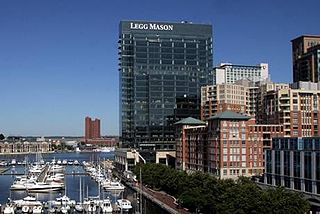
Legg Mason Tower is a 24-story glass high-rise located at 100 International Drive in Baltimore's Harbor East development. Completed in May 2009, the 650,000-square-foot (60,000 m2) waterfront skyscraper was developed by Harbor East Development Group, and reaches a height of 360.5 feet (109.9 m). It was designed by Beatty Harvey Coco Architects with HKS Architects, and is situated at the edge of the city's Inner Harbor. This Class-A office building serves as the new headquarters for asset management firm Legg Mason, which moved from what was the Legg Mason Building at 100 Light Street.
David A. Wallace FAICP, AIA, PP was an urban planner and architect who co-founded, with Ian McHarg, the firm of Wallace Roberts & Todd (WRT).

Charles Center is a large-scale urban redevelopment project in central Baltimore's downtown business district of the late 1950s and early 1960s. Beginning in 1954, a group called the "Committee for Downtown" promoted a master plan for arresting the commercial decline of central Baltimore. In 1955, the "Greater Baltimore Committee", headed by banker and developer James W. Rouse, joined the effort. A plan was developed by noted American urban planner and architect David A. Wallace, (1917−2004), strongly supported by Mayors Thomas L. J. D'Alesandro, Jr. (1947−1959) and Theodore R. McKeldin, and many in their administrations, which formed the basis of a $25 million bond issue voted on by the citizens of Baltimore City during the municipal elections in November 1958. The architects' view of the overall Charles Center Redevelopment Plan with the conceptions of possible buildings, lay-out and plan that was publicized to the voters that spring and summer before, only slightly resembles the actual buildings and designs that later were really constructed by the mid-1970s.
Ehrenkrantz Eckstut & Kuhn Architects (EE&K) is an international architectural firm with offices in New York City, Washington DC, Los Angeles, and Shanghai. EE&K's expertise spans large-scale urban development and infrastructure projects, mixed-use urban development and waterfronts, school and campus design, historic preservation and adaptive re-use.

Baltimore is the most populous city in the U.S. state of Maryland, the fourth most populous city in the Mid-Atlantic, and the 30th most populous city in the United States with a population of 585,708 in 2020. Baltimore was designated an independent city by the Constitution of Maryland in 1851, and today it is the most populous independent city in the nation. As of 2021, the population of the Baltimore metropolitan area was estimated to be 2,838,327, making it the nation's 20th largest metropolitan area. Baltimore is located about 40 miles (64 km) north northeast of Washington, D.C., making it a principal city in the Washington–Baltimore combined statistical area (CSA), the third-largest CSA in the nation, with a 2021 estimated population of 9,946,526.
The Maritime Industrial Zoning Overlay District (MIZOD) was created in Baltimore, Maryland in 2004 to preserve deepwater access for port and maritime industrial uses. As waterfront residential and commercial development encroached on maritime industrial uses within the city, waterfront industries were finding it harder to receive loans from banks to upgrade and expand their operations. MIZOD is a zoning district overlaid across existing industrial zones along the water to allow only industries that use or need deep water access. The Overlay district was set to expire in 2014, but was recently extended to expire in 2024.

McKeldin Square is an area of Downtown Baltimore, located near the Inner Harbor at the corners of Pratt and Light Streets.
Baltimore National Heritage Area is a federally designated National Heritage Area encompassing portions of Baltimore, Maryland, USA. The designated area includes the central portion of the city, waterfront, inner neighborhoods and portions of the city's park system. The district includes Fort McHenry and the Inner Harbor, as well as portions of the Charles Street, Falls Road, National Historic Seaport and Star Spangled Banner Maryland Scenic Byways. The Baltimore National Heritage Area was established on March 30, 2009 by the Omnibus Public Land Management Act of 2009. The designation recognizes the area's unique historic and cultural character, and is intended to stimulate economic development, tourism and historic preservation.
References
- ↑ "Harbor East Directory" . Retrieved 18 August 2010.
- ↑ "Four Seasons Baltimore offers luxury, boost for tourism". The Baltimore Sun. 14 November 2011. Retrieved 23 December 2011.
- ↑ "Baltimore Inner Harbor East". Gilbane Development. Retrieved 4 January 2023.
- 1 2 "Inner Harbor East Baltimore, MD". American Institute of Architects. Archived from the original on 26 October 2008. Retrieved 4 January 2023.
- ↑ The American Institute of Architects. 2000. AIA. 1 July 2008 .”
Coordinates: 39°16′59.5″N76°36′5.75″W / 39.283194°N 76.6015972°W