
Charles Village is a neighborhood located in the north-central area of Baltimore, Maryland, USA. It is a diverse, eclectic, international, largely middle-class area with many single-family homes that is in proximity to many of Baltimore's cultural amenities. Nearby are the Baltimore Museum of Art, The Homewood campus of The Johns Hopkins University, Olmstead's Wyman Park, and the weekly Waverly Farmers Market, and the arts district, Station North. Homes are exemplary Baltimore brick and stone row houses, many dating from the 1890s. Running from downtown north is the historic boulevard, Charles Street, where Baltimore's Easter Promenade once took place.

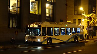
CityLink Navy is a bus route operated by the Maryland Transit Administration in Baltimore. It replaced Route 1 in 2017. The bus route is the successor to the 1 Gilmor Street, 2 Carey Street, and 2 Fort Avenue streetcar lines.

Route 3 is a bus route operated by the Maryland Transit Administration in Baltimore and its suburbs. The line currently runs from the Inner Harbor with most trips operating to Cromwell Bridge Road Park and Ride in Baynesville along the corridors of Loch Raven Boulevard and St. Paul Street, with selected trips to Sheppard Pratt Hospital in Towson, mostly via Joppa Road, and some trips making short turns at Loch Raven and Taylor. It is the successor to the 17 St. Paul Street streetcar line that ran from 1893 to 1938 and the Route T bus that ran from 1939 to 1947.
Quickbus 40 was a limited stop bus route operated by the Maryland Transit Administration in Baltimore and its suburbs. The line was discontinued in June 2017 as part of the BaltimoreLink system rebranding along with the other "Quickbus" limited-stop routes. In April 2022, the MTA announced a proposal to revive the route before the end of the same year as the QuickLink 40.

CityLink Red is a citylink bus route operated by the Maryland Transit Administration in Baltimore and its suburbs. The line currently runs from the University of Maryland Transit Center to the Lutherville Light Rail Stop along the corridors of York Road and Greenmount Avenue, and is the most heavily used MTA bus line. The CityLink Red bus replaced Route 8 bus route due to BaltimoreLink, and is the successor to the 8 Towson and 7 Govanstown streetcar lines.
LocalLink 95 is a bus route operated by the Maryland Transit Administration in Baltimore. The line currently runs from the intersection of Roland Avenue and Lake Avenue in Roland Park south to the Inner Harbor via Roland Avenue, University Parkway, Charles Street and St. Paul Street.

CityLink Gold is a bus route operated by the Maryland Transit Administration in Baltimore. It replaced Route 13 in 2017. The line currently runs from Walbrook Junction in West Baltimore to Canton, mostly along North Avenue. The line has two main branches, both operating to Canton: one that operates via Fells Point and the other via Linwood and East Streets. Both these branches serve Johns Hopkins Hospital. Additionally, selected trips on weekdays and Saturdays operate to the block of Milton Avenue, Federal Street, and Patterson Park Avenue.

LocalLink Route 56 is a bus route operated by the Maryland Transit Administration in Baltimore and its suburbs. The line runs between the Park and Ride station in White Marsh and Charles Center in Downtown Baltimore. In June 2017, LocalLink 56 replaced the former local bus Route 35, which connected the city's downtown area with White Marsh, to the east of the city, and UMBC to the west. Route 35 was the successor to the No. 3 Wilkens Avenue and No, 6 Monument Street streetcar lines.

Waverly is a neighborhood in the north central area of Baltimore, Maryland, located to the north of the adjacent same neighborhood called Better Waverly and west of Ednor Gardens-Lakeside, north and east of Charles Village west of the area of Coldstream-Homestead-Montebello neighborhoods, along with the campus of the former red brick 'H'-shaped building for Eastern High School (1938–1984), facing north towards 33rd Street, now renovated since the 1990s into offices for The Johns Hopkins University, a mile to the west. Adjacent to the east of the Eastern High/Johns Hopkins campus is the landmark tree-shaded campus of The Baltimore City College, at 33rd Street and The Alameda. The College is a massive stone structure with a 150-foot bell tower visible for miles, nicknamed "The Castle on the Hill", constructed 1926–1928 of Collegiate Gothic architecture on one of the highest hills in the city, "Collegian Hill", with the downtown skyline visible to the south. City College is the third oldest public high school in America, founded 1839 in downtown has been through eight different sites in its 179 years of history and five major buildings, each were architectural landmarks in their times. From its beginnings, until 1979, it was a single sex secondary school for boys in the Baltimore City Public Schools, when it co-educated admitting young women. These three major institutions and their sports events dominated the east side of Waverly/Better Waverly for nine decades.

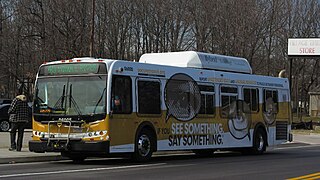
The Maryland Transit Administration provides the primary public bus service for the Baltimore metropolitan area and commuter bus service in other parts of the state of Maryland. There are currently 76 bus routes, which include 45 LocalLink routes, 12 High Frequency CityLink Routes routes, 8 express bus routes, 19 commuter bus routes, and 5 Intercounty Connector or "ICC" routes. The local and commuter bus routes operate in conjunction with one subway line, three light rail lines, MARC train service, and various connections to other transit agencies.
Route 52 is a bus route operated by the Maryland Transit Administration in Baltimore and its suburbs. The line is a dedicated service for employees of Stella Maris, a complex of long term care facilities in Timonium, Maryland. Route 52 replaced Route 12 under BaltimoreLink.
33rd Street, originally called Thirty-third Street Boulevard, is a long, wide, east–west parkway with a broad tree-shaded median strip. It is surrounded by 1920s-era "Daylight-styled" row houses with porches and small front yards. It was designed by the Frederick Law Olmsted Brothers firm, as part of their Baltimore Plan of 1904 and 1921 for establishing stream valley parks and connecting boulevards.

Harwood is a small neighborhood located in the north-central area of Baltimore, Maryland, USA. It sits east of Charles Village, south of Abell, west of Waverly and north of Barclay. Its boundaries are Guilford and Greenmount Avenues to the east and west, and 25th and 29th streets to the north and south. These streets together encompass about 14 city blocks.
Greenspring is a neighborhood in the North District of Baltimore, located between the neighborhoods of Woodberry (east) and Central Park Heights (west). Its boundaries are marked by West Cold Spring Lane (north), Greenspring Avenue (east), and Springhill Avenue (south). The western edge of the neighborhood runs along Pimlico Road from West Cold Spring Lane to Park Heights Avenue, then along Park Heights Avenue to Springhill Avenue.

Beverly Hills is a neighborhood in the Northeast District of Baltimore, located between the neighborhoods of Moravia-Walther, Arcadia and Lauraville. Its boundaries are drawn by Harford Road (west), Weaver Avenue (south), Harcourt Road (east), Moravia Road (northeast) and Grindon Avenue (north).
Callaway-Garrison is a neighborhood in the Northwest district of Baltimore, located between the neighborhoods of Dorchester (west) and Ashburton (east). Its boundaries are marked by West Cold Spring Lane (north), Liberty Heights Avenue (south), Callaway Avenue (east) and Garrison Boulevard (west).
Hanlon Longwood is a neighborhood in the Northwest District of Baltimore, located between the neighborhoods of Garwyn Oaks (west) and Burleigh–Leighton (east). It is bounded by North Dukeland Street (east), Garrison Boulevard (west) and the Gwynns Falls Parkway (south). The neighborhood's north boundary is marked by North Longwood Street, North Hilton Street and Liberty Heights Avenue.
Langston Hughes is a neighborhood in the Northwest District of Baltimore, located between the neighborhoods of Central Park Heights (east) and Woodmere. Its roughly pentagonal boundaries are marked by West Belvedere Avenue (northwest), Litchfield Avenue (northeast), Reisterstown Road (south) and Oakmont Avenue (east).
Westgate is a neighborhood in the Southwest District of Baltimore, located between Baltimore County (west) and the city neighborhood of Ten Hills (east). Its boundaries are marked by Baltimore National Pike (north), Frederick Avenue (south), Rock Glen Avenue and Edmondson Avenue (east) and the city line (west).
