
Fell's Point is a historic waterfront neighborhood in southeastern Baltimore, Maryland. It was established around 1763 and is located along the north shore of the Baltimore Harbor and the Northwest Branch of the Patapsco River. The area has many antique, music and other stores, restaurants, coffee bars, a municipal markethouse with individual stalls, and over 120 pubs. Located 1.5 miles east of Baltimore's downtown central business district and the Jones Falls stream, Fells Point has a maritime past and the air of a seafaring town. It also has the greatest concentration of drinking establishments and restaurants in the city.

Federal Hill is a neighborhood in Baltimore, Maryland, United States that lies just to the south of the city's central business district. Many of the structures are included in the Federal Hill Historic District, listed on the National Register of Historic Places in 1970. Other structures are included in the Federal Hill South Historic District, listed in 2003.

Mount Vernon is a neighborhood immediately north of downtown Baltimore, Maryland. Designated a National Historic Landmark District and a city Cultural District, it is one of the city's oldest neighborhoods and originally was home to the city's wealthiest and most fashionable families. The name derives from the Mount Vernon home of George Washington; the original Washington Monument, a massive pillar commenced in 1815 to commemorate the first president of the United States, is the defining feature of the neighborhood.
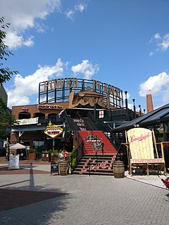
Power Plant Live! is a collection of bars, restaurants and other businesses in the Inner Harbor section of downtown Baltimore, Maryland. It was developed by The Cordish Companies and opened in phases during 2001, 2002, and 2003. The entertainment complex gets its name from the nearby "Power Plant" building, three blocks south on municipal Pier 4 on East Pratt Street facing the Inner Harbor, which was also later re-developed by Cordish.

Mount Washington is an area of northwest Baltimore, Maryland. It is a designated city historic district and divided into two sections: South Road/Sulgrave to the southeast and Dixon's Hill to the north. The Mount Washington Historic District was listed on the National Register of Historic Places in 1990 with a boundary increase in 2001, with five contributing buildings and four contributing structures.
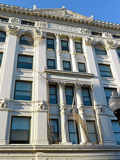
Hutzler's, or Hutzler Brothers Company, was a department store founded in Baltimore by Abram G. Hutzler (1836–1927) in 1858. From its beginning as a small dry goods store at the corner of Howard and Clay Streets in downtown Baltimore, Hutzler's eventually grew into a chain of 10 department stores, all of which were located in Maryland.
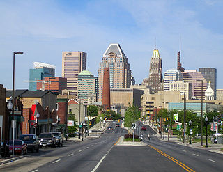
Downtown Baltimore is the central business district of Baltimore traditionally bounded by Martin Luther King, Jr. Boulevard to the west, Franklin Street to the north, President Street to the east and the Inner Harbor area to the south.
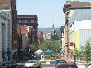
The Downtown Cumberland Historic District, also referred to as the Downtown Cumberland Mall, is the main shopping and dining district for the city of Cumberland, Maryland.

Radnor-Winston is a small community centered near the intersection of York Road and Winston Ave in the North District of Baltimore. Radnor Winston is a friendly, affordable and diverse neighborhood of about 220 homes tucked behind the campuses of Loyola University and The College of Notre Dame. Located in the Roland Park Public School district, the neighborhood is convenient to both downtown Baltimore and Towson.
The Montgomery County Circuit Courthouses are part of the Montgomery County Judicial Center located in downtown Rockville, Maryland. The Red Brick Courthouse, located at 29 Courthouse Square, houses the refurbished Grand Courtroom; the newer Circuit Court building, located at 50 Maryland Avenue, houses the remainder of the county's justice system.

The Business and Government Historic District is a historic district in downtown Baltimore, Maryland, United States, that was listed on the National Register of Historic Places in 1987. The district comprises the center of Baltimore's municipal government and the eastern portion of Baltimore's commercial district. The major feature of the district is the War Memorial Plaza with City Hall to the west and the War Memorial to the east.
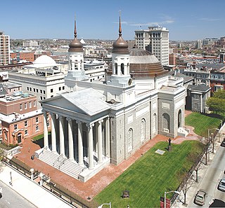
The Cathedral Hill Historic District is an area in Baltimore, Maryland. It lies in the northern part of Downtown just south of Mount Vernon. Roughly bounded by Saratoga Street, Park Avenue, Hamilton Street, and St. Paul Street, these 10 or so blocks contain some of the most significant buildings in Baltimore. The area takes its name from the Basilica of the Assumption which sits in the heart of the district. Despite the number of large religious structures in the area, the district's buildings are primarily commercial in character, with a broad collection of significant commercial structures ranging in date from 1790 to 1940.
Stewart's Department Store, also known as the Posner Building, is a historic department store building located on Howard Street at Baltimore, Maryland, United States. Catholic Relief Services is currently headquartered there.

One Calvert Plaza, formerly the Continental Trust Company Building, is a historic 16-story, 76 m (249 ft) skyscraper in Baltimore, Maryland. The Beaux-Arts, early modern office building was constructed with steel structural members clad with terra cotta fireproofing and tile-arch floors. Its namesake was chartered in 1898 and instrumental in merging several Baltimore light and gas companies into one citywide system. It was constructed in 1900-1901 to designs prepared by D.H. Burnham and Company of Chicago and is a survivor of the Great Baltimore Fire of February 1904, that destroyed more than 100 acres (40 ha) in the present downtown financial district. When it was built in 1901, it was then the tallest building in Baltimore, and it kept that title until being surpassed by the iconic Bromo-Seltzer Tower of the Emerson Drug Company on the northeast corner of West Lombard and South Eutaw Streets on the downtown west side. Led by Capt. Isaac Edward Emerson, (1859-1931), the inventor of the stomach remedy and antacid, "Bromo-Seltzer" in 1911.

Building at 409 West Baltimore Street, also known as the N. Hess & Bro. Building, is a historic retail and wholesale building located at Baltimore, Maryland, United States. It is a four-story brick commercial building with a cast-iron façade above an altered storefront, erected about 1875. Built originally for a wholesale grocery company, it was subsequently occupied by a boot and shoe factory, and a series of wholesale and retail dry goods or clothing stores.

The Loft Historic District North is a national historic district in Baltimore, Maryland, United States. It includes 12 large 19th–early 20th century vertical brick manufacturing buildings centering on Paca, Redwood, and Eutaw Streets near the University of Maryland Campus in downtown Baltimore. Most of the buildings are still used for manufacturing purposes, although a few, including the Heiser, Rosenfeld, and Strauss buildings, have been converted into loft apartments or offices. They are representative of Romanesque, Victorian, and early modern industrial architectural design. It was in this area that Baltimore's garment industry grew to national importance.
Old West Baltimore Historic District is a national historic district in Baltimore, Maryland, United States. It is primarily a row house neighborhood of approximately 175 city blocks directly northwest of downtown Baltimore. The district includes other housing from grand mansions to alley houses, as well as churches, public buildings, commercial buildings, and landscaped squares. Pennsylvania Avenue, the main street of the community, features a later 20th century municipal market house. Within the district are civic monuments that relate to Baltimore's premier historic African-American community. Such noteworthy figures as Supreme Court Justice Thurgood Marshall, Congressman Parren Mitchell, jazz artist Cab Calloway, civil rights leader Lillie Mae Carroll Jackson, and Carl Murphy, editor of the Baltimore Afro-American newspaper, lived and / or worked in the area.

North Central Historic District is a national historic district in Baltimore, Maryland, United States. It is an area of approximately 25 city blocks directly north of downtown Baltimore and includes 630 buildings. The roughly triangular-shaped, mixed-use district comprises late-19th century row housing, commercial storefronts from the turn of the 20th century through the 1950s, large industrial buildings, several older theatres, a church, and two school buildings. A broad variety of row house sizes and types reflects the diversity of the neighborhood's residents, ranging from the large and architecturally elaborate dwellings of the upper class to the small alley houses of working-class African Americans.

East Monument Historic District is a national historic district in Baltimore, Maryland, United States. It is a large residential area with a commercial area located along East Monument Street. It comprises approximately 88 whole and partial blocks. The residential area is composed primarily of row-houses that were developed, beginning in the 1870s, as housing for Baltimore's growing Bohemian (Czech) immigrant community. Most of the homes in the district were created after older homes were demolished in order to make room for expansions to the Johns Hopkins Hospital. During the late 19th and early 20th centuries the neighborhood was the heart of the Bohemian community in Baltimore. The Bohemian National Parish of the Roman Catholic Church, St. Wenceslaus, is located in the neighborhood. The historic district includes all of Mcelderry Park and Milton-Montford, most of Middle East and Madison-Eastend, and parts of Ellwood Park.

Hollins–Roundhouse Historic District is a national historic district in Baltimore, Maryland, United States. It is a primarily residential area characterized by 19th century rowhouses. The neighborhood is historically significant due to its association with the development of rail transportation in Maryland. Additional historical significance comes from the neighborhood's association with ethnic immigration to Baltimore. During the 1840s and 1850s the area was a center of settlement for Baltimore's German and Irish communities, many of whom immigrated to the United States to work in the rail industry. Later, from the 1880s to the 1920s, the neighborhood became established as the center of Baltimore's Lithuanian immigrant community. Because of the large Lithuanian population in the area north of Hollins Street, the area became known as Little Lithuania. A few remnants of the neighborhood's Lithuanian heritage still remain, such as Lithuanian Hall located on Hollins Street.


