The city of Atlanta, Georgia is made up of 243 neighborhoods officially defined by the city. These neighborhoods are a mix of traditional neighborhoods, subdivisions, or groups of subdivisions. The neighborhoods are grouped by the city planning department into 25 neighborhood planning units (NPUs). These NPUs are "citizen advisory councils that make recommendations to the Mayor and City Council on zoning, land use, and other planning issues". There are a variety of other widely recognized named areas within the city. Some are officially designated, while others are more informal.

Charles Village is a neighborhood located in the north-central area of Baltimore, Maryland, USA. It is a diverse, eclectic, international, largely middle-class area with many single-family homes that is in proximity to many of Baltimore's cultural amenities. Nearby are the Baltimore Museum of Art, The Homewood campus of The Johns Hopkins University, Olmstead's Wyman Park, and the weekly Waverly Farmers Market, and the arts district, Station North. Homes are exemplary Baltimore brick and stone row houses, many dating from the 1890s. Running from downtown north is the historic boulevard, Charles Street, where Baltimore's Easter Promenade once took place.

Area codes 847 and 224 are telephone area codes in the North American Numbering Plan (NANP) for the U.S. state of Illinois. The numbering plan area (NPA) comprises the northeastern part of Illinois and many northern suburbs of Chicago. This includes most of Lake County, the northern part of Cook County, the northern part of Kane County, and a small part of McHenry County.
The list of neighborhoods of Kansas City, Missouri has nearly 240 neighborhoods. The list includes only Kansas City, Missouri and not the entire Kansas City metropolitan area, such as Kansas City, Kansas.

U.S. Route 40 in the U.S. state of Maryland runs from Garrett County in Western Maryland to Cecil County in the state's northeastern corner. With a total length of 221 miles (356 km), it is the longest numbered highway in Maryland. Almost half of the road overlaps or parallels with Interstate 68 (I-68) or I-70, while the old alignment is generally known as US 40 Alternate, US 40 Scenic, or Maryland Route 144. West of Baltimore, in the Piedmont and Appalachian Mountains / Blue Ridge region of the Western Maryland panhandle of the small state, the portions where it does not overlap an Interstate highway are mostly two-lane roads. The portion northeast of Baltimore going toward Wilmington in northern Delaware and Philadelphia in southeastern Pennsylvania is a four-lane divided highway, known as the Pulaski Highway. This section crosses the Susquehanna River at the north end of the Chesapeake Bay on the Thomas J. Hatem Memorial Bridge.
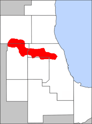
The Golden Corridor is the area around the Jane Addams Memorial Tollway, formerly known as the Northwest Tollway, in the Chicago metropolitan area. Its name refers to the "gold" mine of economic profit for communities in the area. Several Fortune 500 company headquarters, office parks, industrial parks, exhibition and entertainment centers, medical facilities, hotels, shopping centers, and restaurants are in the Golden Corridor. With the exception of the O'Hare area of Chicago, all the communities in this region are part of a larger region known as the "Northwest Suburbs".
Maryland Route 129 is a state highway in the U.S. state of Maryland, running north-northwesterly from U.S. Route 40 and MD 295 in the city of Baltimore into Baltimore County, ending at Garrison Forest Road east of Reisterstown. The route leaves downtown on the one-way pair of McCulloh Street and Druid Hill Avenue, and then uses the entire length of Park Heights Avenue to the end. MD 129 connects Downtown Baltimore with Druid Hill Park using McCulloh Street and Druid Hill Avenue. As Park Heights Avenue, the state highway is one of two primary radial routes in the northwestern part of the city, providing access to The Maryland Zoo and Pimlico Race Course. In Baltimore County, MD 129 passes through Pikesville, where it has a junction with Interstate 695 (I-695) and serves an affluent rural area north of Pikesville and east of Reisterstown.

Waverly is a neighborhood in the north central area of Baltimore, Maryland, located to the north of the adjacent same neighborhood called Better Waverly and west of Ednor Gardens-Lakeside, north and east of Charles Village west of the area of Coldstream-Homestead-Montebello neighborhoods, along with the campus of the former red brick 'H'-shaped building for Eastern High School (1938–1984), facing north towards 33rd Street, now renovated since the 1990s into offices for The Johns Hopkins University, a mile to the west. Adjacent to the east of the Eastern High/Johns Hopkins campus is the landmark tree-shaded campus of The Baltimore City College, at 33rd Street and The Alameda. The College is a massive stone structure with a 150-foot bell tower visible for miles, nicknamed "The Castle on the Hill", constructed 1926–1928 of Collegiate Gothic architecture on one of the highest hills in the city, "Collegian Hill", with the downtown skyline visible to the south. City College is the third oldest public high school in America, founded 1839 in downtown has been through eight different sites in its 179 years of history and five major buildings, each were architectural landmarks in their times. From its beginnings, until 1979, it was a single sex secondary school for boys in the Baltimore City Public Schools, when it co-educated admitting young women. These three major institutions and their sports events dominated the east side of Waverly/Better Waverly for nine decades.
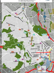
Forest Park is a region of Northwest Baltimore, Maryland located west of Reisterstown Road, south of Northern Parkway, and east of the Baltimore City/County line. In Baltimore, the region is referred to by locals simply as "Forest Park" and includes the neighborhoods of Ashburton, Callaway-Garrison, Central Forest Park, Dolfield, Dorchester, East Arlington, Forest Park, Grove Park, Hanlon Longwood, Howard Park, Garwyn Oaks, Purnell, West Arlington, West Forest Park, and Windsor Hills.

The city of Billings, Montana is subdivided into 11 sections for geographic and planning purposes.

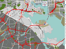
Gywnns Falls Trail is a 15-mile (24 km) series of hiking and bicycling trails inside Baltimore, Maryland, named for the Gwynns Falls, whose course it follows, and the surrounding Gwynns Falls Leakin Park it passes through. The trail uses unique alignments, sidepaths on existing streets, and on-street sections. The trail consists of one 10.75-mile (17.30 km) mainline, plus a number of branches, including the Middle Branch Trail, the Hutton Trail, and the Dickeyville Trail. All of these trails carry signage designating them as the Gwynns Falls Trail; their individual names are designated on the mile markers designating their route. The entirety of the Middle Branch Trail, as well as the section of the mainline trail east of the Middle Branch Trail's northern terminus, are part of the East Coast Greenway.
West Hills is a neighborhood in the Southwest District of Baltimore, located between the neighborhoods of Westgate (south), Franklintown (north) and Hunting Ridge (east). Its boundaries are drawn by the Baltimore County line (west), Baltimore National Pike (south) and North Franklintown Road (north). Its eastern boundary follows Cooks Lane from Baltimore National Pike, then Briarclift Road and finally Wynans Way to the intersection with N. Franklintown Road.
Alexandria, Virginia, an independent city in the Commonwealth of Virginia, is located along the western bank of the Potomac River. The city of approximately 151,000 is about six miles south of downtown Washington, D.C.