Federal Hill is a neighborhood in Baltimore, Maryland, that lies just to the south of the city's central business district. Many of the structures are included in the Federal Hill Historic District, listed on the National Register of Historic Places in 1970. Other structures are included in the Federal Hill South Historic District, listed in 2003.

Canton is a historic waterfront neighborhood in Baltimore, Maryland, United States. The neighborhood is along Baltimore's outer harbor in the southeastern section of the city, roughly 2 miles (3 km) east of Baltimore's downtown district and next to or near the neighborhoods of Patterson Park, Fell's Point, Highlandtown, and Brewers Hill.

Otterbein is a small neighborhood of historic rowhouses in Baltimore, Maryland, United States. Otterbein is immediately southwest of, and in close walking distance to, the Inner Harbor. The neighborhood is very compact, entirely located between Hanover Street and Sharp Street, and between Barre Street and Henrietta Street. It is in small parts of zip codes 21201 and 21230. It is named for Old Otterbein Church, located immediately north of the neighborhood.
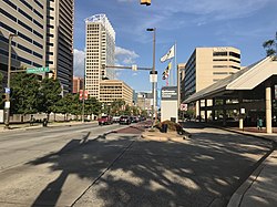
Downtown Baltimore is the central business district of the city of Baltimore traditionally bounded by Martin Luther King, Jr. Boulevard to the west, Franklin Street to the north, President Street to the east and the Inner Harbor area to the south.

Radnor-Winston is a small community centered near the intersection of York Road and Winston Ave in the North District of Baltimore. Radnor Winston is a friendly, affordable and diverse neighborhood of about 220 homes tucked behind the campuses of Loyola University and The College of Notre Dame. Located in the Roland Park Public School district, the neighborhood is convenient to both downtown Baltimore and Towson.

Jonestown is a neighborhood in the southeastern district of Baltimore. Its boundaries are the north side of Pratt Street, the west side of Central Avenue, the east side of Fallsway, and the south side of Orleans Street. The neighborhood lies north of the Little Italy, south of the Old Town, west of the Washington Hill, and east of the Downtown Baltimore neighborhoods. The southern terminus of the Jones Falls Expressway is located here.

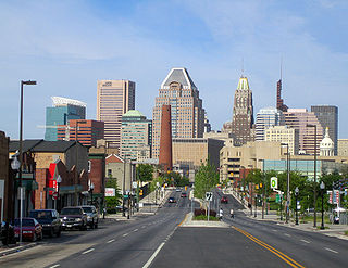
Baltimore is the most populous city in the U.S. state of Maryland. With a population of 585,708 at the 2020 census, it is the 30th-most populous city in the United States. Baltimore was designated an independent city by the Constitution of Maryland in 1851, and today it is the most populous independent city in the nation. As of the 2020 census, the population of the Baltimore metropolitan area was estimated to be 2,838,327, making it the 20th-largest metropolitan area in the country. When combined with the larger Washington, D.C. metropolitan area, the Washington–Baltimore combined statistical area (CSA) has a 2020 U.S. census population of 9,973,383, the third-largest in the country.
Dorchester is a neighborhood in the Northwest District of Baltimore. It is located between the neighborhoods of Arlington (north), Central Forest Park (south), Howard Park (west) and Gallway-Garrison (east). Maryland Route 26 draws boundary between Dorchester and Central Forest Park. Dorchester's other boundaries are marked by Oakford Avenue, Eldorado Avenue and Garrison Boulevard.
The Orchards is a neighborhood in the North District of Baltimore, located between the neighborhoods of New North Roland Park–Poplar Hill and Bellona–Gittings. Its boundaries are marked by the Baltimore County line (north), Maryland Route 133 Northern Parkway (south), and Maryland Route 139 Charles Street (east). Roland Avenue, West Lake Avenue, Kenmore Road and Melrose Avenue draw the neighborhood's west boundary.
Glen Oaks is a neighborhood in the North District of Baltimore. Its boundaries form a slender, inverted triangle, with the city line as the neighborhood's northern base and Belvedere Shopping Center as its southern apex. Chinquapin Parkway (west) and The Alameda (east) draw the triangle's sides and cross at the neighborhood's southern tip.
Edgecomb, also known as Parklane, is a neighborhood in the North District of Baltimore, located between the neighborhoods of Cylburn (north) and Greenspring (south). Its boundaries are marked by Dupont Avenue (north), Coldspring Lane (south), Pimlico Road (west) and Greenspring Avenue (east). Central Park Heights, is located on the opposite side of Pimlico Road in the Northwest District. The neighborhood of Coldspring is located to Edgecomb's east, across Greenspring Avenue.

Cylburn is a neighborhood in the North District of Baltimore, located between the neighborhoods of Levindale (north) and Edgecomb (south). Its boundaries are marked by Cylburn Avenue (north), Dupont Avenue (south), Pimlico Road (west) and Greenspring Avenue (east). Central Park Heights, is located on the opposite side of Pimlico Road in the Northwest area of Baltimore City. Cylburn Arboretum and the neighborhood of Cold Spring are located to Cylburn's east, across Greenspring Avenue. The heavily wooded property with its historic mansion and grounds, walking trails, famous collections and gardens overlook the Jones Falls Valley with the Jones Falls Expressway further to the east.
Garwyn Oaks is a neighborhood in the Northwest District of Baltimore, located between the neighborhoods of Windsor Hills and Hanlon Longwood. The boundaries of its somewhat rectangular shape are marked by Woodhaven Avenue (north), Gwynns Falls Parkway (south), Garrison Boulevard (east) and Chelsea Terrace (west).
Greenspring is a neighborhood in the North District of Baltimore, located between the neighborhoods of Woodberry (east) and Central Park Heights (west). Its boundaries are marked by West Cold Spring Lane (north), Greenspring Avenue (east), and Springhill Avenue (south). The western edge of the neighborhood runs along Pimlico Road from West Cold Spring Lane to Park Heights Avenue, then along Park Heights Avenue to Springhill Avenue.

Reisterstown Station is a neighborhood in the Northwest District of Baltimore, located between the neighborhoods of Glen (northeast) and Grove Park (southwest). The Baltimore County line is the neighborhood's western border. Its other boundaries are drawn by Reisterstown Road (northeast), West Northern Parkway (southeast), Crest Heights Road (northwest), Patterson Avenue and Wabash Avenue (southwest).

Beverly Hills is a neighborhood in the Northeast District of Baltimore, located between the neighborhoods of Moravia-Walther, Arcadia and Lauraville. Its boundaries are drawn by Harford Road (west), Weaver Avenue (south), Harcourt Road (east), Moravia Road (northeast) and Grindon Avenue (north).
Callaway-Garrison is a neighborhood in the Northwest district of Baltimore, located between the neighborhoods of Dorchester (west) and Ashburton (east). Its boundaries are marked by West Cold Spring Lane (north), Liberty Heights Avenue (south), Callaway Avenue (east) and Garrison Boulevard (west).
West Hills is a neighborhood in the Southwest District of Baltimore, located between the neighborhoods of Westgate (south), Franklintown (north) and Hunting Ridge (east). Its boundaries are drawn by the Baltimore County line (west), Baltimore National Pike (south) and North Franklintown Road (north). Its eastern boundary follows Cooks Lane from Baltimore National Pike, then Briarclift Road and finally Wynans Way to the intersection with N. Franklintown Road.

Hollins Market is a neighborhood in the Sowebo area of Baltimore. It takes its name from the Hollins Market, the oldest public market building still in use in Baltimore City, which is located in the heart of the neighborhood.

Westside Baltimore is the western portion of downtown Baltimore that includes Market Center and many of the newest developments in downtown Baltimore. It has increasingly become the preferred residential section of downtown. It is also home to the site of the "Superblock" project that will include hundreds of condos and apartments as well as a variety of retail and commercial space. The former home of Baltimore's many and famed department stores, Westside Baltimore is now anchored by the University of Maryland, Baltimore consisting of the University of Maryland Health System, University of Maryland School of Law and the University of Maryland Biopark. The Westside is also home to several performing arts centers, including the Hippodrome Theatre, Royal Farms Arena and the future home of the Everyman Theatre.