Baltimore Metro SubwayLink

Last updated

Metro SubwayLink
Baltimore Metro SubwayLink Logo for Signage (Blue).svg
MTAMaryland178.jpg
Metro SubwayLink train entering Reisterstown Plaza station and bound for Owings Mills station
Overview
Owner Maryland Transit Administration
Locale Baltimore, Maryland, U.S.
Termini
Stations14
Website mta.maryland.gov/metro-subway
Service
Type Rapid transit
Depot(s)5801 Wabash Avenue [1]
Rolling stock100 Budd Universal Transit Vehicle cars [2]
Daily ridership(weekdays, Q4 2023) [3]
Ridership1,988,300 (2023) [4]
History
OpenedNovember 21, 1983;40 years ago (1983-11-21)
Technical
Line length15.4 mi (24.8 km) [5]
Track length34 mi (55 km) [1]
Number of tracks2
CharacterUnderground, surface, elevated
Track gauge 4 ft 8+12 in (1,435 mm) standard gauge
Electrification Third rail,  700 V DC [5]
Operating speed70 mph (110 km/h) [2]
Highest elevation28 ft (8.5 m) [2]
Route map
Baltimore Metro SubwayLink Metro SubwayLink highlighted in green
BSicon vRP2.svg
BSicon PARKING.svg
BSicon uKBHFa.svg
BSicon vRP2BHF.svg
Owings Mills
BSicon vRP2yRP4l.svg
BSicon vRP2yRP4r.svg
BSicon uSTR.svg
BSicon PARKING.svg
BSicon uBHF.svg
Old Court
BSicon PARKING.svg
BSicon uBHF.svg
Milford Mill
BSicon PARKING.svg
BSicon uhBHFa.svg
Reisterstown Plaza
BSicon uhKDSTaq.svg
BSicon uhABZgr+r.svg
Maintenance and Storage Facility
BSicon PARKING.svg
BSicon uhBHF.svg
Rogers Avenue
BSicon PARKING.svg
BSicon uhtBHFa@f.svg
West Cold Spring
BSicon PARKING.svg
BSicon utBHF.svg
Mondawmin
BSicon utBHF.svg
Penn-North
BSicon utBHF.svg
Upton–Avenue Market
Baltimore Light RailLink logo.svg
BSicon utINT.svg
State Center
Baltimore Light RailLink logo.svg
BSicon utINT.svg
Lexington Market
BSicon utBHF.svg
Charles Center
BSicon utBHF.svg
Shot Tower
BSicon utKBHFe.svg
Johns Hopkins Hospital

Wheelchair symbol.svg All stations are accessible

The Baltimore Metro SubwayLink is a rapid transit line serving Baltimore, Maryland, and its northwestern suburbs, operated by the Maryland Transit Administration. The segment in Downtown Baltimore is underground, while most of the line outside the central city is elevated or at surface grade. [2] In 2023, the line had a ridership of 1,988,300, or about 7,953 per weekday as of the fourth quarter of 2023.

Contents

History

The origins of the Metro SubwayLink lie in the Baltimore Area Mass Transportation Plan published in 1965, which envisioned six rapid transit lines radiating out from a central city loop. Planning studies from 1968 proposed a rail transit system 71 mi (114 km) long. [2]

As the vision was translated into reality, the original concept was trimmed to a 28 mi (45 km) system in the Phase 1 plan, published in 1971. This plan involved two of the original six lines: a northwest line from Downtown Baltimore to Owings Mills and a south line to Glen Burnie and the airport. Phase 1 was approved for funding by the Maryland General Assembly in 1972. In response to lobbying by Anne Arundel County residents, the MTA eliminated the south line from Phase 1 plans in 1975; the Baltimore Light RailLink was later built over much of the planned south line corridor. [2]

When the Metro SubwayLink opened on November 21, 1983, only the "Northwest" line of the 1965 plan had come to fruition. This 7.6 mi (12.2 km) segment provided service between Charles Center in Downtown Baltimore and the Reisterstown Plaza shopping center in the northwest of the city. On July 20, 1987, a 6.1 mi (9.8 km) addition extended the line from Reisterstown Plaza to Owings Mills in Baltimore County, with a portion running in the median of Interstate 795. A further extension of 1.6 mi (2.5 km) from Charles Center to Johns Hopkins Hospital opened on May 31, 1995. [1] [5] Once the project was completed in 1995, the total cost for the Metro SubwayLink stood at $1.392 billion. [2]

The current system is 15.4 mi (24.8 km) long, consisting of 6.2 mi (10 km) underground, 2.2 mi (3.5 km) elevated, and 7.0 mi (11.3 km) at grade. Eight of its 14 stations are underground, at depths from 52 ft (16 m) to 112 ft (34 m) below street level. Its elevated stations stand from 25 ft (7.6 m) to 28 ft (8.5 m) above ground. [5]

When the system opened, it became the largest single user of Susan B. Anthony dollar coins in the United States. [6]

The installation of underground cellular service in the Metro SubwayLink tunnels began in September 2021 and was originally expected to be completed by June 2022. [7] [8] As of January 2024, the work has not been completed.

Operation

Route

The Metro SubwayLink has a single line that is shaped like a reverse "J". Trains head south underground from Johns Hopkins Hospital, turn west as they pass under Baltimore's central business district, turn north at Charles Center, and ultimately turn to face northwest at State Center. The route leaves its tunnel northwest of Mondawmin station, entering an elevated structure that parallels Wabash Avenue and the Hanover Subdivision along the former Western Maryland Railway route. The route then enters the median of Interstate 795, which it occupies until it reaches the Owings Mills terminus.

Trains heading towards Johns Hopkins Hospital are referred to as "eastbound", while trains heading towards Owings Mills are "westbound". [9]

Schedules

A trip from one end of the line to the other takes about half an hour. Headways range from eight minutes during daytime peak to eleven minutes late at night and on weekends. Trains run from 5 a.m. to midnight on weekdays and from 6 a.m. to midnight on weekends. [9]

Fares

As of 2024, the fare prices for MTA buses, the Metro SubwayLink, and the Light RailLink travel are as follows: [10]

TypeFull fareSenior/DisabilityStudentMobility
Single trip$2.00$1.00$1.50$2.20
Day Pass$4.60$2.30
Weekly Pass$22.00
Monthly Pass$77.00$23.00

Farebox recovery

Farebox recovery in the system is only 28%. This is comparable to other similarly sized systems in the continental United States, but low by international standards.[ citation needed ]

Performance

For fiscal year 2010, the MTA reported 95% on-time performance for the system. It averaged 3.0 passenger trips per revenue mile, with a total of 13.4 million passenger trips for the year. Vehicles operated at an average cost of $11.59 per revenue mile. Local buses, in comparison, performed at a cost of $13.57 per revenue mile. [11]

Stations

The Metro SubwayLink has a total of 14 stations. [12]

LocationDistance (mi / km)StationConnections
Owings Mills 0.0 (0) Owings Mills BaltimoreLink: 87, 89
Lochearn 3.6 (5.8) Old Court BaltimoreLink: 37, 83
5.4 (8.7) Milford Mill BaltimoreLink: 81, 85
Glen, Baltimore 6.1 (9.8) Reisterstown Plaza BaltimoreLink: 82
Arlington, Baltimore 7.1 (11.4) Rogers Avenue BaltimoreLink: 28, 30, 31, 34, 80, 82, 89
8.3 (13.4) West Cold Spring BaltimoreLink: 28, 82
Mondawmin, Baltimore 10.1 (16.3) Mondawmin BaltimoreLink: NAVY, LIME, YELLOW, 22, 26, 29, 82, 83, 85, 91
Penn-North, Baltimore 10.8 (17.4) Penn – North BaltimoreLink: LIME, GOLD, 85
Upton, Baltimore 11.3 (18.2) Upton – Avenue Market BaltimoreLink: LIME
Mount Vernon, Baltimore 12.5 (20.1) State Center / Cultural Center BaltimoreLink: LIME, YELLOW, 54, 73, 154, 410

Light RailLink (at Cultural Center)

Downtown, Baltimore 13.3 (21.4) Lexington Market BaltimoreLink: BLUE, 54, 71, 80, 94, 105, 115, 154, 320
Light RailLink (at Lexington Market)
13.8 (22.2) Charles Center BaltimoreLink: ORANGE, GREEN, SILVER, RED, PURPLE, 40, 51, 56, 65, 67, 71, 76, 78, 95, 103, 105, 164, 120, 150, 160, 310, 320, 410, 411
CCC: Purple
14.4 (23.2) Shot Tower BaltimoreLink: ORANGE, BLUE, PURPLE
CCC: Green
Middle East, Baltimore 15.4 (24.8) Johns Hopkins Hospital BaltimoreLink: PINK, GOLD, BROWN, PURPLE, 21, 56, 104, 105, 115, 120, 160, 310, 320, 411, 420
CCC: Green

Connecting services

Most Metro SubwayLink stations are served by a number of MTA bus routes. In 1984, just months after Metro first started operating, many feeder routes were created that were given the designation of a letter (M, P, or R) followed by a number. In 1987, many of these routes were renamed, and only the prefix "M" was used. Over the years, the number of M-lines had shrunk, as many of the routes were consolidated. In 2008, routes designated with the letter "M" were renamed to plain two-digit designations. Finally, on August 30, 2009, the last four were either renumbered or eliminated, with no routing changes made; they continue to act as feeder routes to the Metro SubwayLink.

There is no direct connection from the Metro SubwayLink to the Light RailLink or MARC commuter rail. However, the Metro SubwayLink's Lexington Market Station is a 200-yard (180 m) walk from the Light RailLink stop of the same name, and the State Center station is about 1.5 blocks away from the Light RailLink's Cultural Center station. Baltimore Penn Station is about a one-half mile walk from State Center, and MARC Camden Station is about five blocks from Lexington Market Metro station.

Rolling stock

A universal transit vehicle on the Baltimore Metro SubwayLink departing Milford Mill station MTAM Millford-Mill-departing-train.jpg
A universal transit vehicle on the Baltimore Metro SubwayLink departing Milford Mill station

As of 2024, the line currently uses cars manufactured by the Budd Company in Northeast Philadelphia. The first set of additional, new cars are presently manufactured at Hitachi Rail Italy in Florida. [11] [13] [14]

Most of the 100 Budd-built cars were delivered in 1983 with a supplementary set of essentially identical cars being purchased in 1986 for the line expansion. The cars, marketed by Budd as the Universal Transit Vehicle, are identical to those formerly used on the Miami Metrorail; the two agencies built their systems at the same time and saved money by sharing a single order. [2] A number of Budd cars have been retired. [13]

Trains draw power from the electric third rail. The cars are 75 feet (22.86 m) long, 10 feet (3.05 m) wide, and have a top speed of 70 mph (110 km/h). Cars are semi-permanently attached in married pairs and joined up to form 4-car trains, which is the normal train length. 6-car trains are used during peak rush hours. Each car can hold up to 166 passengers (76 seated, 90 standing). [2]

The fleet had a significant overhaul between 2002 and 2005. Seats were reupholstered, and the floors were replaced. External destination rollsigns were replaced with LED displays; internal systems that display train destinations and upcoming stop announcements were also installed. [15]

In July 2017, MTA announced the purchase of 78 new railcars to replace the entire subway fleet. The cars are being built in Florida by Hitachi Rail Italy, and will be similar in appearance to those purchased for the Miami Metrorail. [13] [16] [17] The Hitachi railcars generate electricity while braking, thus allowing the energy to power certain train systems and enabling the system to become more energy efficient. [13] The first Hitachi cars were delivered in October 2023; the replacement of the rolling stock is set to occur in phases from 2024 to 2026. [13] [14]

Incidents

On February 11, 2018, the MTA announced a month-long closure of the entire system to complete emergency track repairs identified during a safety inspection. An aboveground portion of the system had already been shut down due to emergency inspections and repairs. [18] The system reopened on March 9, 2018. [19]

In the summer of 2023, a fire damaged a portion of the subway system, prompting a brief closure. [20] Regular service resumed a few days later. [20]

See also

Related Research Articles

<span class="mw-page-title-main">Washington Metro</span> Rapid transit system serving the Washington metropolitan area

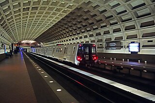
The Washington Metro, often abbreviated as the Metro and formally the Metrorail, is a rapid transit system serving the Washington metropolitan area of the United States. It is administered by the Washington Metropolitan Area Transit Authority (WMATA), which also operates the Metrobus service under the Metro name. Opened in 1976, the network now includes six lines, 98 stations, and 129 miles (208 km) of route.

<span class="mw-page-title-main">New York City Subway</span> Rapid transit system in New York City

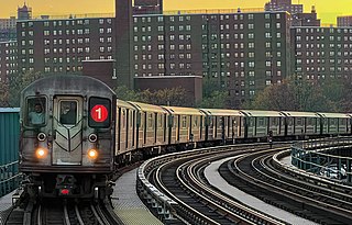
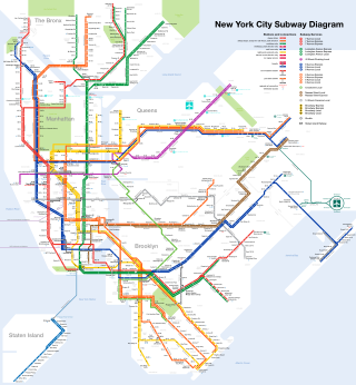
The New York City Subway is a rapid transit system in the New York City boroughs of Manhattan, Brooklyn, Queens, and the Bronx. It is owned by the government of New York City and leased to the New York City Transit Authority, an affiliate agency of the state-run Metropolitan Transportation Authority (MTA). Opened on October 27, 1904, the New York City Subway is one of the world's oldest public transit systems, one of the most-used, and the one with the most stations, with 472 stations in operation.

<span class="mw-page-title-main">Staten Island Railway</span> Rapid transit line in New York City

The Staten Island Railway (SIR) is a rapid transit line in the New York City borough of Staten Island. It is owned by the Staten Island Rapid Transit Operating Authority (SIRTOA), a subsidiary of the Metropolitan Transportation Authority, and operated by the New York City Transit Authority Department of Subways. SIR operates 24 hours a day, seven days a week, providing local service between St. George and Tottenville, along the east side of the island. There is currently only one line on the island, and there is no direct rail link between the SIR and the New York City Subway system, but SIR riders do receive a free transfer to New York City Transit bus and subway lines, and the line is included on official New York City Subway maps. Commuters on the railway typically use the Staten Island Ferry to reach Manhattan. The line is accessible from within the Ferry Terminal, and most of its trains are timed to connect with the ferry. In 2023, the system had a ridership of 6,151,400, or about 19,500 per weekday as of the fourth quarter of 2023.

<span class="mw-page-title-main">Maryland Transit Administration</span> Public transit authority of the state of Maryland

The Maryland Transit Administration (MTA) is a state-operated mass transit administration in Maryland, and is part of the Maryland Department of Transportation. The MTA operates a comprehensive transit system throughout the Washington-Baltimore metropolitan area. There are 80 bus lines serving the Baltimore Metropolitan Area, along with rail services that include the Light Rail, Metro Subway, and MARC Train. In 2023, the system had a ridership of 52,922,000, or about per weekday as of the fourth quarter of 2023.

<span class="mw-page-title-main">PATCO Speedline</span> Rapid transit system in Pennsylvania and New Jersey, United States

The PATCO Speedline, signed in Philadelphia as the Lindenwold Line and also known colloquially as the PATCO High Speed Line, is a rapid transit route operated by the Port Authority Transit Corporation (PATCO), which runs between Philadelphia, Pennsylvania, and Camden County, New Jersey.

<span class="mw-page-title-main">MARC Train</span> U.S. passenger rail system in Baltimore–Washington metropolitan area

MARC is a commuter rail system in the Washington–Baltimore area. MARC is administered by the Maryland Transit Administration (MTA) and operated under contract by Alstom and Amtrak on track owned by CSX Transportation (CSXT) and Amtrak. In 2023, the system had a ridership of 3,860,600, or about 12,400 per weekday as of the fourth quarter of 2023, less than pre-COVID-19 pandemic weekday ridership of 40,000.

<span class="mw-page-title-main">New York City Subway stations</span> Rapid transit system in New York City

The New York City Subway is a rapid transit system that serves four of the five boroughs of New York City, New York: the Bronx, Brooklyn, Manhattan, and Queens. Its operator is the New York City Transit Authority, which is itself controlled by the Metropolitan Transportation Authority of New York. In 2015, an average of 5.65 million passengers used the system daily, making it the busiest rapid transit system in the United States and the 11th busiest in the world.

<span class="mw-page-title-main">Muni Metro</span> Light rail system in San Francisco, California

Muni Metro is a semi-metro system serving San Francisco, California, United States. Operated by the San Francisco Municipal Railway (Muni), a part of the San Francisco Municipal Transportation Agency (SFMTA), Muni's light rail lines saw an average of 75,500 boardings per day as of the fourth quarter of 2023 and a total of 24,324,600 boardings in 2023, making it the sixth-busiest light rail system in the United States.

<span class="mw-page-title-main">Los Angeles Metro Rail</span> Urban rail transit system serving Los Angeles County, California

The Los Angeles Metro Rail is an urban rail transit system serving Los Angeles County, California in the United States. It consists of six lines: four light rail lines and two rapid transit lines, serving a total of 101 stations. It connects with the Metro Busway bus rapid transit system, the Metrolink commuter rail system, as well as several Amtrak lines. Metro Rail is owned and operated by the Los Angeles County Metropolitan Transportation Authority (Metro).

<span class="mw-page-title-main">B Line (Los Angeles Metro)</span> Rapid transit line in Los Angeles, California

The B Line is a fully underground 14.7 mi (23.7 km) rapid transit line operating in Los Angeles, running between North Hollywood and Downtown Los Angeles. It is one of six lines in the Los Angeles Metro Rail system, operated by the Los Angeles County Metropolitan Transportation Authority. Built in four stages between 1986 and 2000, the line cost $4.5 billion.

<span class="mw-page-title-main">A Line (Los Angeles Metro)</span> Light rail line in Los Angeles County, California

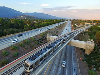
The A Line is a 48.5-mile (78.1 km) light rail line in Los Angeles County, California. It is one of the six lines of the Los Angeles Metro Rail system, operated by the Los Angeles County Metropolitan Transportation Authority (Metro). The A Line serves 44 stations and runs east-west between Azusa and Pasadena, then north-south between Pasadena and Long Beach. It interlines and shares five stations with the E Line in Downtown Los Angeles. Service operates for approximately 19 hours with headways of up to 8 minutes during peak hours. The A Line is currently the longest light rail line in the world.

<span class="mw-page-title-main">Baltimore Light RailLink</span> Light rail system in Baltimore

The Baltimore Light RailLink is a light rail system serving Baltimore, Maryland, United States, and its northern and southern suburbs. It is operated by the Maryland Transit Administration. In downtown Baltimore, it uses city streets. Outside the central portions of the city, the line is built on private rights-of-way, mostly from the defunct Northern Central Railway, Baltimore and Annapolis Railroad and Washington, Baltimore and Annapolis Electric Railway. The system had a ridership of 3,546,300, or about 12,500 per weekday, as of the fourth quarter of 2023.

<span class="mw-page-title-main">D Line (Los Angeles Metro)</span> Rapid transit line in Los Angeles, California

The D Line is a fully underground 5.1-mile (8.2 km) rapid transit line operating in Los Angeles, running between Koreatown and Downtown Los Angeles. It is one of six lines on the Metro Rail system, operated by the Los Angeles County Metropolitan Transportation Authority.

<span class="mw-page-title-main">M1/M3 (railcar)</span> Long Island Rail Road and Metro-North car

The M1 and M3 are two similar series of electric multiple unit rail cars built by the Budd Company for the Long Island Rail Road, the Metro-North Railroad and Metro-North's predecessors, Penn Central and Conrail. Originally branded by Budd as Metropolitans, the cars are more popularly known under their model names, M1 and M3. The Metro-North cars were branded under the M1A and M3A series.

<span class="mw-page-title-main">M2/M4/M6 (railcar)</span> Long Island Rail Road and Metro-North car

The M2, M4 and M6 were three similar series of electric multiple unit rail cars produced by the Budd Company (M2), Tokyu Car Corporation (M4), and Morrison-Knudsen (M6) for the Metropolitan Transportation Authority (MTA) and the Connecticut Department of Transportation (ConnDOT). Initially branded as the Cosmopolitans, the cars were later more popularly known under their model names, M2, M4, M6. They ran on the New Haven Line for most of their service life.

<span class="mw-page-title-main">Metrorail (Miami-Dade County)</span> Rapid-transit rail system in Miami, Florida

Metrorail is a rapid transit system in Miami and Miami-Dade County in the U.S. state of Florida. Metrorail is operated by Miami-Dade Transit (MDT), a departmental agency of Miami-Dade County. Opened in 1984, it is Florida's only rapid transit metro system, and is currently composed of two lines of 23 stations on 24.4 miles (39.3 km) of standard gauge track. Metrorail serves the urban core of Miami, connecting Miami International Airport, the Health District, Downtown Miami, and Brickell with the northern developed neighborhoods of Hialeah and Medley to the northwest, and to suburban The Roads, Coconut Grove, Coral Gables, and South Miami, ending at urban Dadeland in Kendall. Metrorail connects to the Metromover in Downtown, which provides metro service to the entirety of Downtown and Brickell. Additionally, it connects to South Florida's commuter rail system at Tri-Rail station, as well as Metrobus routes at all stations. In 2023, the system had 13,439,300 rides, and about 48,300 per day in the fourth quarter of 2023.

<span class="mw-page-title-main">Penn Line</span> MARC commuter rail service from Washington, D.C., to Perryville, Maryland

The Penn Line is a MARC passenger rail service operating between Union Station in Washington, D.C., and Perryville, Maryland, along the far southern leg of the Northeast Corridor; most trains terminate at Baltimore's Penn Station. It is MARC's only electrified line. However, a majority of trips remain diesel powered. With trains operating at speeds of up to 125 miles per hour (201 km/h), it is the fastest commuter rail line in the United States. The service is operated by Amtrak under contract to the Maryland Transit Administration. MARC sets the schedules, owns most of the stations, and controls fares, while Amtrak owns and maintains the right-of-way, supplies employees to operate trains, and maintains the rolling stock. It is the busiest of MARC's three lines, with twice as many trains and ridership as the Brunswick and Camden lines combined.

<span class="mw-page-title-main">Mondawmin station</span> Metro SubwayLink station

Mondawmin station is a Metro SubwayLink station in Baltimore, Maryland. It is located under the intersection of Reisterstown Road and Liberty Heights Avenue in the Mondawmin neighborhood, adjacent to the Mondawmin Mall. It is the northernmost underground station on the line, and a major transfer point to many bus routes.

<span class="mw-page-title-main">MBTA subway</span> Boston region transit service

The Massachusetts Bay Transportation Authority (MBTA) operates rapid transit, light rail, and bus rapid transit services in the Boston metropolitan area, collectively referred to as the rapid transit, subway, or the T system.

<span class="mw-page-title-main">Budd Universal Transit Vehicle</span>

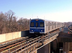
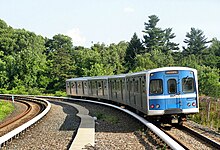
The Budd Universal Transit Vehicle is an electric multiple unit heavy rail car built for use on the Baltimore Metro SubwayLink and Miami-Dade Metrorail systems. They were built by the Budd Company from 1983 to 1986, and were the last cars ever built by Budd before the company shuttered its railcar manufacturing business.

References

  1. 1 2 3 "MTA Media Guide 2010–2011" (PDF). MTA Maryland. August 2010. pp. 4, 9, 10. Retrieved June 30, 2011.
  2. 1 2 3 4 5 6 7 8 9 Scott M. Kozel (October 13, 2002). "Baltimore Metro Subway". Roads to the Future. Archived from the original on August 8, 2002. Retrieved June 28, 2002.
  3. "Transit Ridership Report Fourth Quarter 2023" (PDF). American Public Transportation Association. March 4, 2024. Retrieved March 14, 2024.
  4. "Transit Ridership Report Fourth Quarter 2023" (PDF). American Public Transportation Association. March 4, 2024. Retrieved March 14, 2024.
  5. 1 2 3 4 Robert Schwandl. "Baltimore Metro Subway". UrbanRail.Net. Retrieved November 27, 2014.
  6. Valentine, Paul W. (April 2, 1984). "Underground Coin". The Washington Post. Retrieved May 28, 2019.
  7. Metro SubwayLink Cornerstone Plan (PDF) (Report). Maryland Department of Transportation, Maryland Transit Administration. August 28, 2019. p. 36. Retrieved November 18, 2021.
  8. Arnold, Holly (June 29, 2021). Franchise Agreement Report: Summary of Service Disruptions & Asset Conditions – Metro SubwayLink and Light RailLink (Report). Maryland Department of Transportation, Maryland Transit Administration. p. 5. Retrieved November 18, 2021.
  9. 1 2 "Metro Subway". MTA Maryland. Retrieved June 30, 2011.
  10. 1 2 "Regular Fares". Maryland Transit Administration. Retrieved June 27, 2022.
  11. 1 2 "2012 Annual Report" (PDF). MTA Maryland. p. 30. Retrieved October 10, 2013.
  12. "Metro Subway Schedule" (PDF). MTA Maryland. Retrieved June 30, 2011.
  13. 1 2 3 4 5 Zawodny, Daniel (September 22, 2023). "Baltimore subway to get first new railcars in 40 years". The Baltimore Banner. Retrieved February 7, 2024.
  14. 1 2 BATRAK, OLEKSANDR (October 3, 2023). "New Metro Cars from Hitachi Rail for Baltimore". Railway Supply. Retrieved January 14, 2024.
  15. Krishnamurthy, B.; Causey, R.; Shockley, T. C.; Garrettson, G. A. (2001). "METRO HEAVY RAIL MID-LIFE OVERHAUL NEEDS ASSESSMENT: BALTIMORE, MARYLAND". American Public Transportation Association. 8.
  16. "Maryland Transit Administration". mta.maryland.gov.
  17. "MDOT MTA Wins Approval for $400.5M Purchase of Metro SubwayLink Railcars and Train Control System". Mass Transit. July 31, 2017. Retrieved November 16, 2021.
  18. Campbell, Colin (February 11, 2018). "Entire Baltimore Metro system to close for a month for emergency repairs". Baltimore Sun. Retrieved February 11, 2018.
  19. Richman, Talia. "Riders relieved as Baltimore Metro Subway reopens after monthlong shutdown". baltimoresun.com. Retrieved April 1, 2018.
  20. 1 2 Zawodny, Daniel (July 12, 2023). "Repairs continue on Baltimore subway as service resumes days after fire". The Baltimore Banner. Retrieved February 7, 2024.
Template:Attached KML/Baltimore Metro SubwayLink
KML is from Wikidata