
Baltimore/Washington International Thurgood Marshall Airport, commonly referred to as Baltimore/Washington International Airport, BWI, and BWI Marshall, is an international airport in Anne Arundel County, Maryland, located 9 miles (14 km) south of downtown Baltimore and 30 miles (50 km) northeast of Washington, D.C.

Linthicum is a census-designated place (CDP) and unincorporated community in Anne Arundel County, Maryland, United States. The population was 10,324 at the 2010 census. It is located directly north of Baltimore–Washington International Thurgood Marshall Airport (BWI).
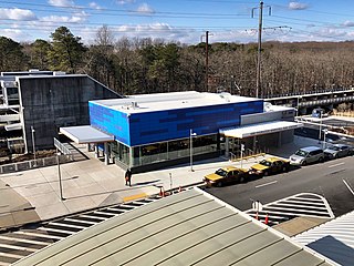
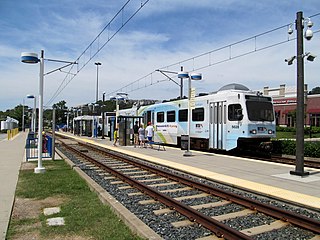
BWI Rail Station is an intermodal passenger station in Linthicum, Maryland near Baltimore/Washington International Airport (BWI). It is served by Amtrak Northeast Corridor intercity trains, MARC Penn Line regional rail trains, and several local bus lines.

Maryland Route 170 is a state highway in the U.S. state of Maryland. The state highway runs 12.98 miles (20.89 km) from MD 175 in Odenton north to MD 2 in Brooklyn Park. MD 170 connects the western Anne Arundel County communities of Odenton and Severn and the North County communities of Linthicum, Pumphrey, and Brooklyn Park with Baltimore/Washington International Thurgood Marshall Airport. The highway connects BWI Airport with Interstate 695 (I-695) and MD 100 and forms part of the Airport Loop, a circumferential highway that connects the airport and I-195 with many airport-related services.

The Baltimore Light RailLink is a light rail system serving Baltimore, Maryland, United States, and its northern and southern suburbs. It is operated by the Maryland Transit Administration. In downtown Baltimore, it uses city streets. Outside the central portions of the city, the line is built on private rights-of-way, mostly from the defunct Northern Central Railway, Baltimore and Annapolis Railroad and Washington, Baltimore and Annapolis Electric Railway. The system had a ridership of 3,262,100, or about 14,600 per weekday, as of the third quarter of 2023.
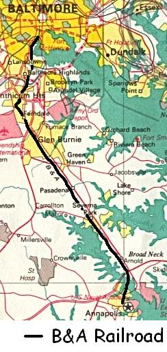
The Baltimore & Annapolis Railroad was an American railroad of central Maryland built in the 19th century. The railroad, the second to serve Annapolis, ran between Annapolis and Clifford along the north shore of the Severn River. From Clifford, just north of the present day Patapsco Light Rail Stop, it connected with the B&O's Curtis Bay branch so that trains could travel to Baltimore. In 1921, when it was called the Annapolis and Baltimore Short Line, it was purchased by the larger Washington, Baltimore and Annapolis Electric Railway (WB&A), and then emerged from the WB&A's 1935 bankruptcy and closure as the Baltimore & Annapolis Railroad. B&A electric passenger operation between the two cities continued until 1950, at which time the rail line became solely a freight carrier, operating buses for passenger service. Freight service to Annapolis continued until June 1968 when the Severn River Trestle was declared unsafe. In the 1980s, the line was completely shut down. The right-of-way now serves as part of Baltimore's light rail system and as the Baltimore & Annapolis Trail.
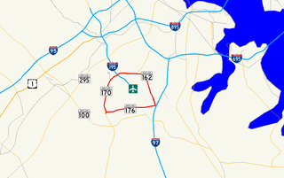
Airport Loop is the designation for the portions of state highways that form a circumferential highway around Baltimore/Washington International Thurgood Marshall Airport in Anne Arundel County in the U.S. state of Maryland. The loop runs 8.44 miles (13.58 km) through the communities of Linthicum, Ferndale, and Hanover. Airport Loop consists of a 3.47-mile (5.58 km) section of Maryland Route 170 (MD 170) along the western and northern sides of the loop; the entire 2.31-mile (3.72 km) length of MD 162 on the eastern side of the loop; and a 2.66-mile (4.28 km) segment of MD 176 on the southern side of the loop. Airport Loop intersects Interstate 195 (I-195), which provides freeway access to the airport terminal, and is connected to I-695, I-97, and MD 100 via connecting highways. The MD 170 and MD 162 sections of Airport Loop are part of the National Highway System.

LocalLink 75 is a bus route operated by the Maryland Transit Administration in Baltimore and its suburbs. The line currently runs from the Patapsco Light Rail Stop to Arundel Mills in Anne Arundel County, via BWI Airport. The line operates to University of Maryland during hours when the light rail is not operating.

Camden Station, now also referred to as Camden Street Station, Camden Yards, and formally as the Transportation Center at Camden Yards, is a train station at the intersection of South Howard and West Camden Streets in Baltimore, Maryland, adjacent to Oriole Park at Camden Yards, behind the B&O Warehouse. It is served by MARC commuter rail service and local Light Rail trains.
Fairgrounds station is a Baltimore Light RailLink station located adjacent to the Maryland State Fairgrounds in Timonium, Maryland. The station has two side platforms serving two tracks.

Patapsco station is a Baltimore Light Rail station in Halethorpe, Maryland. The stop is located along Patapsco Avenue from which its name is derived. The station serves as a hub for several MTA bus routes. Patapsco was the final stop along the line for a period from September 1992 until April 1993, when the line was extended to Linthicum.

BWI Airport station is a Baltimore Light RailLink station at the Baltimore-Washington International Airport in Maryland. It is one of the two southern terminals of the Baltimore Light Rail. The station platforms are just outside an entrance to the International Concourse on the lower level.
Hunt Valley station is a Baltimore Light Rail station located at the Hunt Valley Towne Centre shopping complex in Hunt Valley, Maryland. The station opened in 1997 as the terminus of a northern extension of the Light Rail system. It has a single island platform serving two tracks, which continue east of the platform as tail tracks.

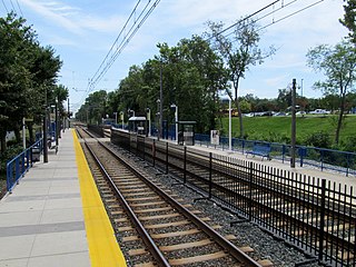
Linthicum station is a Baltimore Light Rail station in Linthicum Heights, Maryland. This station is the last station on the light rail's trunk line; southbound trains depart onto branches to BWI Marshall Airport station and Glen Burnie station. There is currently no free public parking or bus connections at this station.

BWI Business District station is a Baltimore Light Rail station in the BWI Business District, north of the Baltimore-Washington International Airport in Linthicum, Maryland. There are currently 36 free public parking spaces and connections can be made to MTA Maryland's Route 17 and 99 buses, and Howard Transit's Silver Route from this station. Additionally, portions of the BWI Trail can be found across the street from the parking lot.

The Washington, Baltimore and Annapolis Electric Railway (WB&A) was an American railroad of central Maryland and Washington, D.C., built in the 19th and 20th century. The WB&A absorbed two older railroads, the Annapolis and Elk Ridge Railroad and the Baltimore & Annapolis Short Line, and added its own electric streetcar line between Baltimore and Washington. It was built by a group of Cleveland, Ohio, electric railway entrepreneurs to serve as a high-speed, showpiece line using the most advanced technology of the time. It served Washington, Baltimore, and Annapolis, Maryland, for 27 years before the "Great Depression" and the rise of the automobile forced an end to passenger service during the economic pressures of the 1930s "Depression" southwest to Washington from Baltimore & west from Annapolis in 1935. Only the Baltimore & Annapolis portion between the state's largest city and its state capital continued to operate electric rail cars for another two decades, replaced by a bus service during the late 1950s into 1968. Today, parts of the right-of-way are used for the light rail line, rail trail for hiking - biking trails, and roads through Anne Arundel County.
The Yellow Line is a mass transit line proposed by the Baltimore Regional Rail Plan in March 2002 for the Baltimore, Maryland area. It would begin at Columbia Town Center in Columbia, Maryland, and end in Hunt Valley, Maryland at Shawan Road.
UMBC Transit is the official bus system of the University of Maryland, Baltimore County. Along with the Maryland Transit Administration (MTA), the UMBC community has public transit access to nearby areas such as Catonsville, Arbutus, Maryland, and Baltimore City.
The BWI Business District is a neighborhood and business district in Linthicum and Hanover that features over 11,000 hotel rooms and numerous office parks and shopping centers. As the name suggests, the business district is benefited by nearby Baltimore/Washington International Airport.
The BWI Marshall Airport Shuttle is a free bus service provided by Baltimore–Washington International Airport, that connects the airport terminal to BWI Rail Station. The free shuttle connects airport passengers to Amtrak and MARC trains, hence connecting the airport to Baltimore and Washington, D.C., as well as the rest of the Northeastern United States.
