
The Maryland Transit Administration (MTA) is a state-operated mass transit administration in Maryland, and is part of the Maryland Department of Transportation. The MTA operates a comprehensive transit system throughout the Washington-Baltimore metropolitan area. There are 80 bus lines serving the Baltimore Metropolitan Area, along with rail services that include the Light Rail, Metro Subway, and MARC Train. In 2023, the system had a ridership of 52,922,000, or about per weekday as of the fourth quarter of 2023.

Interstate 795 (I-795), also known as the Northwest Expressway, is a nine-mile (14 km) auxiliary Interstate Highway linking Baltimore's northwestern suburbs of Pikesville, Owings Mills, and Reisterstown, Maryland, to the Baltimore Beltway (I-695). The route bypasses Maryland Route 140, carrying part of the Maryland Transit Administration (MTA)'s Baltimore Metro SubwayLink in its median for a four-mile (6.4 km) stretch, and provides direct access to the former Owings Mills Mall. It never connects to its parent, I-95, except via I-695.

The Baltimore Metro SubwayLink is a rapid transit line serving Baltimore, Maryland, and its northwestern suburbs, operated by the Maryland Transit Administration. The segment in Downtown Baltimore is underground, while most of the line outside the central city is elevated or at surface grade. In 2023, the line had a ridership of 1,988,300, or about 7,953 per weekday as of the fourth quarter of 2023.
Northern Parkway is a major road that runs west–east across the northern part of the city Baltimore. For most of the way, it is at least six lanes wide, and it is used by motorists for crosstown travel. It is designated E. Northern Pkwy and W. Northern Pkwy with Charles Street being the dividing line. It was constructed in the 1950s through several neighborhoods and several homes were razed in the process from right-of-way. The section of E. Northern Pkwy from Harford Road to Fleetwood Ave was originally called German Lane.

Route 7 was a bus route operated by the Maryland Transit Administration in Baltimore. The line, which operated between 1959 and 2017, ran from Canton, Baltimore to the Mondawmin Metro Subway Station, serving the communities of Butcher's Hill, Little Italy, and Sandtown-Winchester.
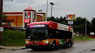
CityLink Pink is a bus route operated by the Maryland Transit Administration in Baltimore. The line currently runs from Cedonia in northeast Baltimore to the West Baltimore MARC station.

Mondawmin station is a Metro SubwayLink station in Baltimore, Maryland. It is located under the intersection of Reisterstown Road and Liberty Heights Avenue in the Mondawmin neighborhood, adjacent to the Mondawmin Mall. It is the northernmost underground station on the line, and a major transfer point to many bus routes.
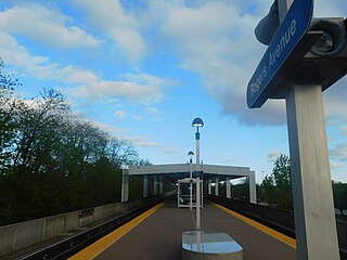
Rogers Avenue station is a Metro SubwayLink station in Baltimore, Maryland. It is located in the Woodmere area, and is the fifth most northern and western station on the line, with approximately 900 parking spaces.

West Cold Spring station is a Metro SubwayLink station in Baltimore, Maryland. It is located at the intersection of Wabash Avenue and Cold Spring Lane in the Arlington neighborhood, adjacent to the Towanda-Grantley neighborhood. It is the sixth most northern and western station on the line, with approximately 300 parking spaces.

Penn-North station is an underground Baltimore Metro SubwayLink station and transit hub serving many buses in West Baltimore, Maryland. Its name comes from its location and neighborhood it serves Penn-North, at the corner of Pennsylvania and North Avenues. It is the deepest underground station, eighth most northern and western station on the line, and the first station when starting from Owings Mills that does not have free parking.

Route 51 is a bus route operated by the Maryland Transit Administration in Baltimore and its suburbs. The line currently runs from the Rogers Avenue Metro Subway Station to the Patapsco Light Rail Stop, serving the communities of Arlington, Ashburton, Mondawmin, Rosemont, Baltimore, Cherry Hill, and Mt. Winans, and the suburb of Baltimore Highlands.

LocalLink 30 is a bus route operated by the Maryland Transit Administration in Baltimore and its suburbs. It replaced route 44 following the 2017 BaltimoreLink overhaul of the bus network. The line currently runs from Rosedale Industrial Park near Pulaski Highway just outside the Baltimore city limits on the east side of the city across the northern portion of the city to Security Square Mall, with selected peak hour trips to the Social Security Administration. Some early morning trips before 7 AM lay over at the Centers for Medicare and Medicaid Services (CMS) headquarters. The line operates mostly along Frankford Avenue, Echodale Avenue, East Belvedere Avenue, Northern Parkway, Rogers Avenue, and Gwynn Oak Avenue, serving the communities of Gardenville, Hamilton, Belvedere Park, Homeland, Roland Park, Pimlico, and Arlington, and the western suburb of Woodlawn.

Wabash Avenue is a six-lane boulevard in northwest Baltimore, Maryland, that runs from Patterson Avenue to Hilton Street, mostly through the Arlington community, crossing over Northern Parkway and Cold Spring Lane along the way. The road starts near the Reisterstown Plaza Metro Subway Station and continues to just past the West Coldspring Metro Subway Station, where it narrows and becomes a one-way pair with Dorithan Road, which ends several blocks later at Hilton Street.
LocalLink 85 is a bus route that operates in Baltimore and its suburbs. All trips operate from the Penn-North Metro Subway Station in Baltimore City to the Milford Mill Metro Subway Station in Pikesville. The route, which started operating on August 24, 2008, is a combination of the most recent versions of the former routes M-3 and M-8, which had been operating since 1984 and 1987 respectively. Prior to these dates, the routes had been served by other buses and streetcars.

Route 58 is a bus route operated by the Maryland Transit Administration in Baltimore and its suburbs. The line's western terminus is the Reisterstown Plaza Metro Subway Station, and its eastern terminus is White Marsh Mall, though some peak hour trips make short turns in Overlea. Route 58 serves the communities of Glen, Cheswolde, Fallstaff, a large section of Northern Parkway, and a portion of Belair Road in Baltimore County.

Route 34 is a bus route operated by the Maryland Transit Administration in Baltimore and its suburbs. The line currently operates weekdays only from the Reisterstown Plaza Metro Subway Station to Stevenson University during peak hours and Greenspring Station midday.

LocalLink 89 is a bus route operated by the Maryland Transit Administration in Baltimore and its suburbs, mostly along Reisterstown Road. The line currently runs from the Reisterstown Plaza Metro Subway Station to the Owings Mills Town Center. The line replaced original Route 59 under BaltimoreLink, and was a split-off from Route M-9, and resembles the pre-1997 route of Route M-9. It is the successor to several other bus routes and streetcars.

LocalLink 87 is a bus route operated by the Maryland Transit Administration in the suburbs of Baltimore. The route currently runs from the Owings Mills Town Center to Glyndon via Reisterstown Road and the Owings Mills Metro Subway Station. The line, which was a split-off from the final version of the now defunct Route M-9, and resembles the former Route M-16 that operated from 1987 to 1998. The route was previously named No. 56 before BaltimoreLink, when it was replaced in its entirety by Route 87.
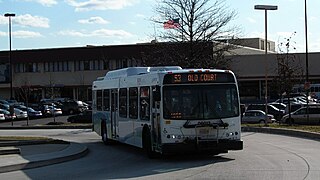
LocalLink 83 is a bus route in Baltimore and its suburbs. The line currently runs from the Old Court Metro Subway Station in Pikesville, Maryland to the Mondawmin Metro Subway Station in Northwest Baltimore along Old Court Road and Reisterstown Road, serving the communities of Park Heights and the Reisterstown Road Plaza. The line is the successor to Bus Route 7, which still operates south of Mondawmin. Route 7 operated along Reisterstown Road outside the Metro's hours of operation until 2001.

Reisterstown Station is a neighborhood in the Northwest District of Baltimore, located between the neighborhoods of Glen (northeast) and Grove Park (southwest). The Baltimore County line is the neighborhood's western border. Its other boundaries are drawn by Reisterstown Road (northeast), West Northern Parkway (southeast), Crest Heights Road (northwest), Patterson Avenue and Wabash Avenue (southwest).


