The Maryland Transit Administration (MTA) is a state-operated mass transit administration in Maryland, and is part of the Maryland Department of Transportation. The MTA operates a comprehensive transit system throughout the Washington-Baltimore metropolitan area. There are 80 bus lines serving the Baltimore Metropolitan Area, along with rail services that include the Light Rail, Metro Subway, and MARC Train. In 2023, the system had a ridership of 52,922,000, or about per weekday as of the fourth quarter of 2023.

The Red Line is a rapid transit line of the Washington Metro system, consisting of 27 stations in Montgomery County, Maryland, and Washington, D.C., in the United States. It is a primary line through downtown Washington and the oldest and busiest line in the system. It forms a long, narrow "U," capped by its terminal stations at Shady Grove and Glenmont.
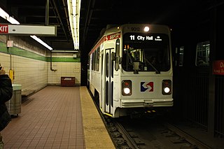
The SEPTA subway–surface trolley lines are a collection of five SEPTA trolley lines that operate on street-level tracks in West Philadelphia and Delaware County, Pennsylvania, and also underneath Market Street in Philadelphia's Center City. The lines, Routes 10, 11, 13, 34, and 36, collectively operate on about 39.6 miles (63.7 km) of route.

Mondawmin is a neighborhood located in the Western district of Baltimore, Maryland, United States. The neighborhood is surrounded by Druid Hill Park, the Whitelock Community, and Lower Park Heights. Included within its boundaries are Frederick Douglass High School, and Mondawmin Mall. The Baltimore Metro Subway serves the neighborhood, with a station at Mondawmin Mall that is also a hub for many bus routes.

The Baltimore Metro SubwayLink is a rapid transit line serving Baltimore, Maryland, and its northwestern suburbs, operated by the Maryland Transit Administration. The segment in Downtown Baltimore is underground, while most of the line outside the central city is elevated or at surface grade. In 2023, the line had a ridership of 1,988,300, or about 7,953 per weekday as of the fourth quarter of 2023.

The Baltimore Light RailLink is a light rail system serving Baltimore, Maryland, United States, and its northern and southern suburbs. It is operated by the Maryland Transit Administration. In downtown Baltimore, it uses city streets. Outside the central portions of the city, the line is built on private rights-of-way, mostly from the defunct Northern Central Railway, Baltimore and Annapolis Railroad and Washington, Baltimore and Annapolis Electric Railway. The system had a ridership of 3,546,300, or about 12,500 per weekday, as of the fourth quarter of 2023.

LocalLink 80 is a bus route operated by the Maryland Transit Administration in Baltimore, Maryland, in the United States. LocalLink 80 is part of the high frequency network of the local bus system. The route consists of a leg originating in Downtown Baltimore and goes on to serve the Garrison Boulevard corridor in the northwest of the city. Route 80 and its predecessor, route 91, has carried some of the highest ridership out of Baltimore's local bus network throughout its history. The line was the first in the city to be assigned articulated buses, which are now used to meet the higher capacity requirements of the frequent lines.
Milford Mill Road, Slade Avenue, and Smith Avenue are a long road mostly in Baltimore County, Maryland that runs through Milford Mill and Pikesville in the suburbs of Baltimore. The road starts out at the light rail stop in historic Mt. Washington Village in Baltimore city as Smith Avenue, and continues through Pikesville up to Seven Mile Lane before its name changes to Slade Avenue, and the road widens to four lanes. The road is known as Slade Avenue until Reisterstown Road, and from there, its name becomes Milford Mill Road until it dead-ends one block south of Rolling Road in an area known as Windsor Mill. It is one of the most heavily used routes in the northwest suburbs of Baltimore, as it is used for cross-county travel by motorists between the Pikesville and Randallstown areas.

Mondawmin station is a Metro SubwayLink station in Baltimore, Maryland. It is located under the intersection of Reisterstown Road and Liberty Heights Avenue in the Mondawmin neighborhood, adjacent to the Mondawmin Mall. It is the northernmost underground station on the line, and a major transfer point to many bus routes.

Reisterstown Plaza station is a Metro SubwayLink station in Baltimore, Maryland. It is located at the intersection of Patterson and Wabash Avenues, and is the fourth most northern and western station on the line, with approximately 700 parking spaces.
Rogers Avenue station is a Metro SubwayLink station in Baltimore, Maryland. It is located in the Woodmere area, and is the fifth most northern and western station on the line, with approximately 900 parking spaces.
Upton–Avenue Market station is an underground Metro SubwayLink station in West Baltimore, Maryland located near the intersection of Pennsylvania Avenue and Laurens Street. The station takes its name from the surrounding Upton neighborhood and the nearby Avenue Market at 1700 Pennsylvania Avenue. It is the ninth most northern and western station on the line.
State Center station is an underground Baltimore Metro SubwayLink station in Baltimore, Maryland. It is a transit hub offering connections to the Baltimore Light RailLink system, the tenth most northern and western station on the line, the first one in the area viewed by many as "downtown Baltimore," and is within a 2 block walk of the Cultural Center station on the Light RailLink syste, via Preston Street, and many area landmarks.

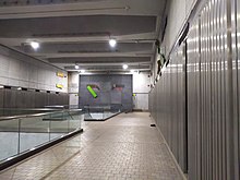
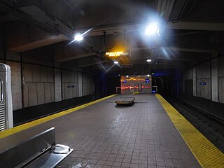
Shot Tower station is an underground Metro SubwayLink station in Baltimore, Maryland. It is in the central part of the city, in close proximity to many well-known landmarks, including the Shot Tower for which it is named, Port Discovery, Power Plant Live!, the Harbor campus of Baltimore City Community College, the National Aquarium, the Flag House, and Little Italy. The station has two street-level entrances, but unlike other Baltimore Metro stations that do, both these entrances share a common gate inside the station. The Shot Tower station is one of two stops in the third phase of the Baltimore Metro, having opened in 1995. Originally named Shot Tower/Market Place to showcase the proximity to the Market Place development, MTA Maryland dropped Market Place from its title with the 2017 rebranding of BaltimoreLink.

Johns Hopkins Hospital station is an underground Metro SubwayLink station in Baltimore, Maryland. It is located by Johns Hopkins Hospital, and is the final stop on the line.

Wabash Avenue is a six-lane boulevard in northwest Baltimore, Maryland, that runs from Patterson Avenue to Hilton Street, mostly through the Arlington community, crossing over Northern Parkway and Cold Spring Lane along the way. The road starts near the Reisterstown Plaza Metro Subway Station and continues to just past the West Coldspring Metro Subway Station, where it narrows and becomes a one-way pair with Dorithan Road, which ends several blocks later at Hilton Street.
LocalLink 85 is a bus route that operates in Baltimore and its suburbs. All trips operate from the Penn-North Metro Subway Station in Baltimore City to the Milford Mill Metro Subway Station in Pikesville. The route, which started operating on August 24, 2008, is a combination of the most recent versions of the former routes M-3 and M-8, which had been operating since 1984 and 1987 respectively. Prior to these dates, the routes had been served by other buses and streetcars.

Penn-North is a neighborhood in the city of Baltimore, Maryland, United States. It is located southwest of Druid Hill Park, west of Reservoir Hill, north of Bolton Hill, and east of Mondawmin. It is bounded Northeast by the Druid Park Lake Drive, the West and Northwest by Fulton Ave., the South by North Avenue, and East by McCulloh Street. It is contained in the 21217 ZIP code.

Avenue is an underground light rail transit (LRT) station under construction on Line 5 Eglinton, a new line that is part of the Toronto subway system. The station is located in North Toronto on Eglinton Avenue between Avenue Road and Highbourne Road. It is the deepest underground station on the line. Destinations include the Chaplin Estates neighbourhood, Marshall McLuhan Catholic Secondary School, the Eglinton Theatre, and Eglinton Park. The station is scheduled to open in 2024.

The West Baltimore Innovation Village District is a neighborhood district of Baltimore City that will specialize in attracting startup companies and other employers to West Baltimore. Following the Death of Freddie Gray and the subsequent 2015 Baltimore protests, government leaders decided to launch the innovation district as a way to attract redevelopment and revitalization to the areas hardest hit by the protests. The district includes the neighborhoods of Mondawmin, Coppin Heights, Penn-North, Reservoir Hill and Bolton Hill.