Westport is the name of several communities around the world.

Maryland Route 648 is a collection of state highways in the U.S. state of Maryland. These nine highways are current or former sections of the Baltimore–Annapolis Boulevard between Annapolis and Baltimore via Glen Burnie. There are five signed mainline segments of MD 648 through Arnold, Severna Park, Pasadena, Glen Burnie, Ferndale, and Pumphrey in northern Anne Arundel County; Baltimore Highlands in southern Baltimore County; and the independent city of Baltimore. MD 648 mainly serves local traffic along its meandering route, with long-distance traffic intended to use the parallel and straighter MD 2 south of Glen Burnie and freeway-grade Interstate 97 (I-97), I-695, and MD 295 between Glen Burnie and Baltimore.

Baltimore Light RailLink is a light rail system serving Baltimore, Maryland, United States, and its northern and southern suburbs. It is operated by the Maryland Transit Administration. In downtown Baltimore, it uses city streets. Outside the central portions of the city, the line is built on private rights-of-way, mostly from the defunct Northern Central Railway, Baltimore and Annapolis Railroad and Washington, Baltimore and Annapolis Electric Railway. The system had a ridership of 3,262,100, or about 14,600 per weekday, as of the third quarter of 2023.

Westport is a neighborhood in south Baltimore, Maryland. Westport is a majority African-American neighborhood that has struggled with crime, housing abandonment, and unemployment in the past decade. The neighborhood is bordered by the Middle Branch of the Patapsco River on the east, the city neighborhoods of Cherry Hill, Brooklyn and the southwestern Baltimore County community of Lansdowne to the southwest, Hollins Ferry Road and the Mount Winans and Lakeland neighborhoods to the west, and Interstate 95 to the north, along with the South Baltimore communities of Federal Hill and Otterbein. The Baltimore–Washington Parkway runs through the middle of Westport and intersects with Interstate 95, the main East Coast super-highway, north to south, Maine to Florida.
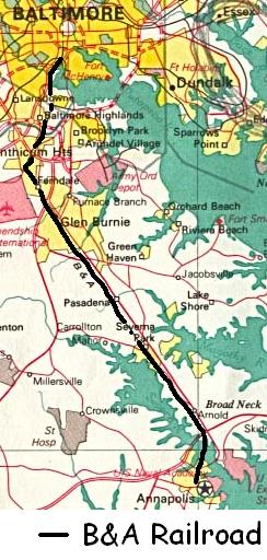
The Baltimore & Annapolis Railroad was an American railroad of central Maryland built in the 19th century. The railroad, the second to serve Annapolis, ran between Annapolis and Clifford along the north shore of the Severn River. From Clifford, just north of the present day Patapsco Light Rail Stop, it connected with the B&O's Curtis Bay branch so that trains could travel to Baltimore. In 1921, when it was called the Annapolis and Baltimore Short Line, it was purchased by the larger Washington, Baltimore and Annapolis Electric Railway (WB&A), and then emerged from the WB&A's 1935 bankruptcy and closure as the Baltimore & Annapolis Railroad. B&A electric passenger operation between the two cities continued until 1950, at which time the rail line became solely a freight carrier, operating buses for passenger service. Freight service to Annapolis continued until June 1968 when the Severn River Trestle was declared unsafe. In the 1980s, the line was completely shut down. The right-of-way now serves as part of Baltimore's light rail system and as the Baltimore & Annapolis Trail.

Brunswick is a passenger rail station on the MARC Brunswick Line between Washington, D.C., and Martinsburg, West Virginia. The station house, located at 100 South Maple Street in Brunswick, Maryland, is a former Baltimore and Ohio Railroad depot that is a contributing property to the Brunswick Historic District, which has been listed on the National Register of Historic Places since August 29, 1979. The station was designed by Ephraim Francis Baldwin and opened in 1891 on Seventh Avenue. Several years later the building was moved to its current location. It is a wooden frame building with stone walls up to the window sills, and features Palladian windows in the roof dormers.
Rogers Avenue station is a Metro SubwayLink station in Baltimore, Maryland. It is located in the Woodmere area, and is the fifth most northern and western station on the line, with approximately 900 parking spaces.
State Center station is an underground Baltimore Metro SubwayLink station in Baltimore, Maryland. It is a transit hub offering connections to the Baltimore Light RailLink system, the tenth most northern and western station on the line, the first one in the area viewed by many as "downtown Baltimore," and is within a 2 block walk of the Cultural Center station on the Light RailLink syste, via Preston Street, and many area landmarks.

Shot Tower station is an underground Metro SubwayLink station in Baltimore, Maryland. It is in the central part of the city, in close proximity to many well-known landmarks, including the Shot Tower for which it is named, Port Discovery, Power Plant Live!, the Harbor campus of Baltimore City Community College, the National Aquarium, the Flag House, and Little Italy. The station has two street-level entrances, but unlike other Baltimore Metro stations that do, both these entrances share a common gate inside the station. The Shot Tower station is one of two stops in the third phase of the Baltimore Metro, having opened in 1995. Originally named Shot Tower/Market Place to showcase the proximity to the Market Place development, MTA Maryland dropped Market Place from its title with the 2017 rebranding of BaltimoreLink.

Mt. Vernon station is a Baltimore Light RailLink station in the Mount Vernon neighborhood of Baltimore, Maryland.

Baltimore Arena station is a Baltimore Light RailLink station in Baltimore, Maryland adjacent to the CFG Bank Arena.

Woodberry station is a Baltimore Light Rail station in the Woodberry neighborhood of Baltimore, Maryland, United States. The station has two side platforms serving two tracks.
Convention Center station is a Baltimore Light Rail station in Baltimore, Maryland. It is located adjacent to the Baltimore Convention Center, and is also near the entrance to Oriole Park at Camden Yards. The Convention Center stop was originally called Pratt Street after the cross street by that name.

Stadium/Federal Hill station is a Baltimore Light RailLink station in Baltimore, Maryland, located adjacent to M&T Bank Stadium. Although built to serve the stadium, it also provides access to the nearby Federal Hill and Pigtown neighborhoods.

Mt. Royal/MICA station, often referred to interchangeably as University of Baltimore/Mt. Royal station, is a Baltimore Light RailLink station in Baltimore, Maryland. It is on the northwest edge of the University of Baltimore campus and on the northern edge of the MICA campus, across Mount Royal Avenue from the site of Baltimore & Ohio Railroad's former Mount Royal Station. It opened in 1992 as part of the line's initial operating segment. The station's construction was funded by the University of Baltimore for the use of its students after the State of Maryland proposed its elimination from the plan to reduce costs.

Cultural Center station is a Baltimore Light RailLink station located along Howard Street in the Mount Vernon neighborhood of Baltimore, Maryland, adjacent to the Joseph Meyerhoff Symphony Hall. It has two side platforms served by two tracks. The station opened on April 2, 1992, as part of the first phase of the system.

Lexington Market station is a Baltimore Light RailLink station adjacent to Lexington Market in Baltimore, Maryland. The station has two side platforms on the sidewalks of Howard Street. Lexington Market station on the Baltimore Metro SubwayLink is located one block to the west.

BWI Business District station is a Baltimore Light Rail station in the BWI Business District, north of the Baltimore-Washington International Airport in Linthicum, Maryland. There are currently 36 free public parking spaces and connections can be made to MTA Maryland's Route 17 and 99 buses, and Howard Transit's Silver Route from this station. Additionally, portions of the BWI Trail can be found across the street from the parking lot.

The Washington, Baltimore and Annapolis Electric Railway (WB&A) was an American railroad of central Maryland and Washington, D.C., built in the 19th and 20th century. The WB&A absorbed two older railroads, the Annapolis and Elk Ridge Railroad and the Baltimore & Annapolis Short Line, and added its own electric streetcar line between Baltimore and Washington. It was built by a group of Cleveland, Ohio, electric railway entrepreneurs to serve as a high-speed, showpiece line using the most advanced technology of the time. It served Washington, Baltimore, and Annapolis, Maryland, for 27 years before the "Great Depression" and the rise of the automobile forced an end to passenger service during the economic pressures of the 1930s "Depression" southwest to Washington from Baltimore & west from Annapolis in 1935. Only the Baltimore & Annapolis portion between the state's largest city and its state capital continued to operate electric rail cars for another two decades, replaced by a bus service during the late 1950s into 1968. Today, parts of the right-of-way are used for the light rail line, rail trail for hiking - biking trails, and roads through Anne Arundel County.
