
Elkridge is an unincorporated community and census-designated place (CDP) in Howard County, Maryland, United States. The population was 15,593 at the 2010 census. Founded early in the 18th century, Elkridge is adjacent to two other counties, Anne Arundel and Baltimore.

The Maryland Transit Administration (MTA) is a state-operated mass transit administration in Maryland, and is part of the Maryland Department of Transportation. The MTA operates a comprehensive transit system throughout the Washington-Baltimore metropolitan area. There are 80 bus lines serving the Baltimore Metropolitan Area, along with rail services that include the Light Rail, Metro Subway, and MARC Train. In 2022, the system had a ridership of 52,922,000, or about per weekday as of the third quarter of 2023.

MARC is a commuter rail system in the Washington–Baltimore area. MARC is administered by the Maryland Transit Administration (MTA) and operated under contract by Alstom and Amtrak on track owned by CSX Transportation (CSXT) and Amtrak. In 2022, the system had a ridership of 2,815,900, or about 12,100 per weekday as of the third quarter of 2023, less than pre-COVID-19 pandemic weekday ridership of 40,000.
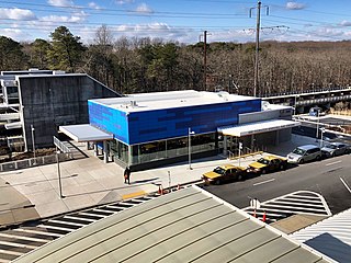
BWI Rail Station is an intermodal passenger station in Linthicum, Maryland near Baltimore/Washington International Airport (BWI). It is served by Amtrak Northeast Corridor intercity trains, MARC Penn Line regional rail trains, and several local bus lines.

West Baltimore station is a commuter rail station located in the western part Baltimore, Maryland, along the Northeast Corridor. It is served by MARC Penn Line trains. The station is positioned on an elevated grade at 400 Smallwood Street near parallel West Mulberry and West Franklin Streets extending off U.S. Route 40. Three large surface lots are available for commuters. The station only has staircases from street level and two low-level side platforms next to the outer tracks and is thus not accessible to people with some mobility disabilities, but MTA Maryland plans to renovate the station with accessible platforms and entrances.

The Baltimore Light RailLink is a light rail system serving Baltimore, Maryland, United States, and its northern and southern suburbs. It is operated by the Maryland Transit Administration. In downtown Baltimore, it uses city streets. Outside the central portions of the city, the line is built on private rights-of-way, mostly from the defunct Northern Central Railway, Baltimore and Annapolis Railroad and Washington, Baltimore and Annapolis Electric Railway. The system had a ridership of 3,262,100, or about 14,600 per weekday, as of the third quarter of 2023.
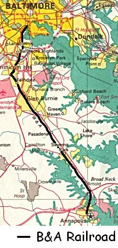
The Baltimore & Annapolis Railroad was an American railroad of central Maryland built in the 19th century. The railroad, the second to serve Annapolis, ran between Annapolis and Clifford along the north shore of the Severn River. From Clifford, just north of the present day Patapsco Light Rail Stop, it connected with the B&O's Curtis Bay branch so that trains could travel to Baltimore. In 1921, when it was called the Annapolis and Baltimore Short Line, it was purchased by the larger Washington, Baltimore and Annapolis Electric Railway (WB&A), and then emerged from the WB&A's 1935 bankruptcy and closure as the Baltimore & Annapolis Railroad. B&A electric passenger operation between the two cities continued until 1950, at which time the rail line became solely a freight carrier, operating buses for passenger service. Freight service to Annapolis continued until June 1968 when the Severn River Trestle was declared unsafe. In the 1980s, the line was completely shut down. The right-of-way now serves as part of Baltimore's light rail system and as the Baltimore & Annapolis Trail.

LocalLink 70 is a bus route operated by the Maryland Transit Administration between Baltimore and Annapolis, Maryland. At most times, the line operates from the Patapsco light rail station in southern Baltimore County with short turns at Jumper's Hole in Pasadena. The bus route, one of the longest local routes operated by MTA, is the successor to the Baltimore and Annapolis Railroad interurban, and mainly operates along the parallel Ritchie Highway, serving Brooklyn Park, Glen Burnie, Pasadena, and Severna Park. When the Light Rail is not running, the 70 runs all the way to downtown Baltimore, mostly along Hanover Street.

LocalLink 75 is a bus route operated by the Maryland Transit Administration in Baltimore and its suburbs. The line currently runs from the Patapsco Light Rail Stop to Arundel Mills in Anne Arundel County, via BWI Airport. The line operates to University of Maryland during hours when the light rail is not operating.
Milford Mill Road, Slade Avenue, and Smith Avenue are a long road mostly in Baltimore County, Maryland that runs through Milford Mill and Pikesville in the suburbs of Baltimore. The road starts out at the light rail stop in historic Mt. Washington Village in Baltimore city as Smith Avenue, and continues through Pikesville up to Seven Mile Lane before its name changes to Slade Avenue, and the road widens to four lanes. The road is known as Slade Avenue until Reisterstown Road, and from there, its name becomes Milford Mill Road until it dead-ends one block south of Rolling Road in an area known as Windsor Mill. It is one of the most heavily used routes in the northwest suburbs of Baltimore, as it is used for cross-county travel by motorists between the Pikesville and Randallstown areas.

Route 64 was a bus route operated by the Maryland Transit Administration in Baltimore and its suburbs. The line ran from the intersection of North Avenue and St. Paul Street to Curtis Bay, with selected trips to Energy Parkway and Riviera Beach. The line also served Federal Hill, Port Covington, and Brooklyn.
Baltimore Highlands station is a Baltimore Light Rail stop in Halethorpe, Maryland. There are currently 50 free parking spaces. There are no bus connections at this station.

Route 77 is a bus route operated by the Maryland Transit Administration in the suburbs of Baltimore. The line currently runs from the Old Court Metro Subway Station in Pikesville, Maryland, to the Patapsco Light Rail Stop and serves Randallstown, Windsor Mill, Woodlawn, Catonsville, Arbutus, Halethorpe, and Lansdowne as well as the campuses of UMBC and CCBC Catonsville.

Route 51 is a bus route operated by the Maryland Transit Administration in Baltimore and its suburbs. The line currently runs from the Rogers Avenue Metro Subway Station to the Patapsco Light Rail Stop, serving the communities of Arlington, Ashburton, Mondawmin, Rosemont, Baltimore, Cherry Hill, and Mt. Winans, and the suburb of Baltimore Highlands.
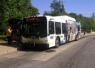
Route 29 was a bus route operated by the Maryland Transit Administration in Baltimore. The line operated on weekdays and Saturdays in a circular fashion, linking the Cherry Hill Light Rail Stop to the Cherry Hill community. Two other MTA bus lines, formerly the routes 27 and 51, also served the Cherry Hill area.

Nursery Road station is a Baltimore Light Rail station in Pumphrey, Maryland. There are 37 free parking spaces and connections can be made to MTA Maryland's Route 17 bus from here.

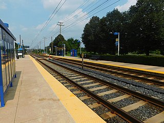
Linthicum station is a Baltimore Light Rail station in Linthicum Heights, Maryland. This station is the last station on the light rail's trunk line; southbound trains depart onto branches to BWI Marshall Airport station and Glen Burnie station. There is currently no free public parking or bus connections at this station.

LocalLink 22 is a bus route operated by the Maryland Transit Administration in Baltimore. The line currently operates between the Mondawmin Metro Subway Station and Bayview Medical Center, serving Television Hill, the Woodberry Light Rail Stop, Hampden, The Rotunda, Homewood, Johns Hopkins University, Waverly, Belair-Edison, and Highlandtown.

The Baltimore Terminal Subdivision is a railroad line owned and operated by CSX Transportation in the U.S. state of Maryland. The line runs from Baltimore to Halethorpe along the original Baltimore and Ohio Railroad (B&O) line, one of the oldest rail lines in the United States and the first passenger railroad line. At its east (north) end, it connects with the Philadelphia Subdivision; its west (south) end has a junction with the Capital Subdivision and the Old Main Line Subdivision.
UMBC Transit is the official bus system of the University of Maryland, Baltimore County. Along with the Maryland Transit Administration (MTA), the UMBC community has public transit access to nearby areas such as Catonsville, Arbutus, Maryland, and Baltimore City.
