
Owings Mills is an unincorporated community and census-designated place in Baltimore County, Maryland, United States. It is a suburb of Baltimore. Per the 2020 census, the population was 35,674. Owings Mills is home to the northern terminus of the Baltimore Metro Subway, and housed the Owings Mills Mall until its closure in 2015. It is also home to the Baltimore Ravens' headquarters facility, and the studios for Maryland Public Television. In 2008, CNNMoney.com named Owings Mills number 49 of the "100 Best Places to Live and Launch".

The Maryland Transit Administration (MTA) is a state-operated mass transit administration in Maryland, and is part of the Maryland Department of Transportation. The MTA operates a comprehensive transit system throughout the Washington-Baltimore metropolitan area. There are 80 bus lines serving the Baltimore Metropolitan Area, along with rail services that include the Light Rail, Metro Subway, and MARC Train. In 2023, the system had a ridership of 52,922,000, or about per weekday as of the fourth quarter of 2023.

Interstate 795 (I-795), also known as the Northwest Expressway, is a nine-mile (14 km) auxiliary Interstate Highway linking Baltimore's northwestern suburbs of Pikesville, Owings Mills, and Reisterstown, Maryland, to the Baltimore Beltway (I-695). The route bypasses Maryland Route 140, carrying part of the Maryland Transit Administration (MTA)'s Baltimore Metro SubwayLink in its median for a four-mile (6.4 km) stretch, and provides direct access to the former Owings Mills Mall. It never connects to its parent, I-95, except via I-695.

Greenbelt station is a Washington Metro and MARC station in Prince George's County, Maryland. The station is the northeastern terminus of the Green Line of the Washington Metro. MARC commuter rail trains on the Camden Line also stop at Greenbelt on a set of tracks parallel to the Metro tracks.

York Mills is a neighbourhood in Toronto, Ontario, Canada. It is centred around Yonge Street and York Mills Road located in the district of North York. In 2010, it encompassed the fourth and seventh most affluent postal codes in Canada. It is recognized as a millionaires' mile, alongside the other Toronto neighbourhoods of The Bridlepath, Forest Hill, and Rosedale.

York Mills is a subway station on Line 1 Yonge–University in Toronto, Ontario, Canada. It is located at 4015 Yonge Street at the intersection of Wilson Avenue and York Mills Road in the neighbourhood of Hoggs Hollow.

Don Mills is a subway station that is the eastern terminus of Line 4 Sheppard in Toronto, Ontario, Canada. The station is at the northeast corner of Sheppard Avenue East and Don Mills Road, within the residential communities of Don Valley Village and Henry Farm, adjacent to Fairview Mall shopping centre. The station is close to Highways 401 and 404, as well as the Don Valley Parkway. Other nearby landmarks include Fairview Mall, Georges Vanier Secondary School, and the Fairview district branch of the Toronto Public Library.

Kipling is the western terminus station of Line 2 Bloor–Danforth of the Toronto subway system. The station is served by buses and subway trains operated by the Toronto Transit Commission and is adjacent to the Kipling GO Station on the Milton line of GO Transit and the Kipling Bus Terminal, where passengers can connect with MiWay and GO Transit bus services. It is located in the Islington–City Centre West neighbourhood on St. Albans Road at Aukland Road, west of the overpass of Kipling Avenue, after which the station is named. The 900 Airport Express bus route connects Kipling to the Toronto Pearson International Airport.

Islington is a subway station on Line 2 Bloor–Danforth of the Toronto subway in Toronto, Ontario, Canada. It is located on the north side of Bloor Street West on the west side of Islington Avenue. A central platform serves trains running in both directions.
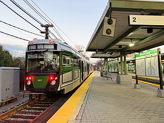
Riverside station is a Massachusetts Bay Transportation Authority (MBTA) Green Line light rail station located in the Auburndale village of Newton, Massachusetts. It is the western terminal of the Green Line D branch service. The station is located near the interchange of Interstate 95 and the Massachusetts Turnpike (I-90) and serves as a regional park and ride station. West of the station is Riverside Yard, the main maintenance facility and largest storage yard for the Green Line. The station is fully accessible.

The Baltimore Metro SubwayLink is a rapid transit line serving Baltimore, Maryland, and its northwestern suburbs, operated by the Maryland Transit Administration. The segment in Downtown Baltimore is underground, while most of the line outside the central city is elevated or at surface grade. In 2023, the line had a ridership of 1,988,300, or about 7,953 per weekday as of the fourth quarter of 2023.

Route 7 was a bus route operated by the Maryland Transit Administration in Baltimore. The line, which operated between 1959 and 2017, ran from Canton, Baltimore to the Mondawmin Metro Subway Station, serving the communities of Butcher's Hill, Little Italy, and Sandtown-Winchester.
Metro Centre at Owings Mills, previously Owings Mills Town Center, is a partially-completed $220 million transit-oriented development in Owings Mills, Maryland aimed at creating a downtown meeting place on the land between the Owings Mills Metro Station and the former Owings Mills Mall. The complex will include housing, shops, office space, a hotel, a library, and a community college. In addition, a new garage has been constructed on the Metro station lot to replace some of the parking spaces that the Metro will lose to the town center.

Owings Mills Mall was a shopping mall in Owings Mills, Maryland, United States that hosted 155 stores and eateries, in the Baltimore County, Maryland, community of Owings Mills. It was owned and managed by General Growth Properties. While its main entrance was off Red Run Boulevard between Painters Mill Road and Owings Mills Boulevard, the mall was also accessible from the exit ramps of I-795. It was originally known as Owings Mills Town Center. The mall was completely demolished in 2017, and redeveloped in 2019 as Mill Station.

Owings Mills Boulevard is a county- and state-maintained highway in the U.S. state of Maryland. The highway runs 7.8 miles (12.6 km) from Liberty Road near Randallstown north to Bond Avenue near Glyndon. Maryland Route 940 is the designation for the 1.48-mile (2.38 km) state highway portion of Owings Mills Boulevard between Red Run Boulevard and MD 140 that is centered on Owings Mills Boulevard's interchange with Interstate 795 (I-795) in Owings Mills in western Baltimore County. Owings Mills Boulevard was first constructed in the mid- to late 1980s. The highway was extended both north and south in the early 1990s and in the early 2000s. Owings Mills Boulevard was extended south in two sections, with the latter section completed to MD 26 in 2016.

Reisterstown Plaza station is a Metro SubwayLink station in Baltimore, Maryland. It is located at the intersection of Patterson and Wabash Avenues, and is the fourth most northern and western station on the line, with approximately 700 parking spaces.

Penn-North station is an underground Baltimore Metro SubwayLink station and transit hub serving many buses in West Baltimore, Maryland. Its name comes from its location and neighborhood it serves Penn-North, at the corner of Pennsylvania and North Avenues. It is the deepest underground station, eighth most northern and western station on the line, and the first station when starting from Owings Mills that does not have free parking.
LocalLink 85 is a bus route that operates in Baltimore and its suburbs. All trips operate from the Penn-North Metro Subway Station in Baltimore City to the Milford Mill Metro Subway Station in Pikesville. The route, which started operating on August 24, 2008, is a combination of the most recent versions of the former routes M-3 and M-8, which had been operating since 1984 and 1987 respectively. Prior to these dates, the routes had been served by other buses and streetcars.

LocalLink 89 is a bus route operated by the Maryland Transit Administration in Baltimore and its suburbs, mostly along Reisterstown Road. The line currently runs from the Reisterstown Plaza Metro Subway Station to the Owings Mills Town Center. The line replaced original Route 59 under BaltimoreLink, and was a split-off from Route M-9, and resembles the pre-1997 route of Route M-9. It is the successor to several other bus routes and streetcars.

LocalLink 87 is a bus route operated by the Maryland Transit Administration in the suburbs of Baltimore. The route currently runs from the Owings Mills Town Center to Glyndon via Reisterstown Road and the Owings Mills Metro Subway Station. The line, which was a split-off from the final version of the now defunct Route M-9, and resembles the former Route M-16 that operated from 1987 to 1998. The route was previously named No. 56 before BaltimoreLink, when it was replaced in its entirety by Route 87.

