
The Maryland Transit Administration (MTA) is a state-operated mass transit administration in Maryland, and is part of the Maryland Department of Transportation. The MTA operates a comprehensive transit system throughout the Washington-Baltimore metropolitan area. There are 80 bus lines serving the Baltimore Metropolitan Area, along with rail services that include the Light Rail, Metro Subway, and MARC Train. In 2023, the system had a ridership of 52,922,000, or about per weekday as of the fourth quarter of 2023.

The 68th Street–Hunter College station is a local station on the IRT Lexington Avenue Line of the New York City Subway, located at the intersection of Lexington Avenue and 68th Street on the Upper East Side of Manhattan. It is served by the 6 train at all times, the <6> train during weekdays in the peak direction, and the 4 train during late nights.
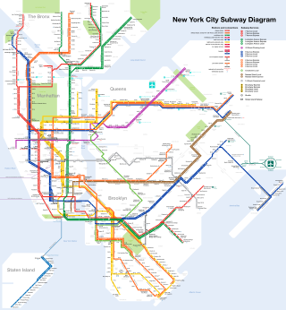
The New York City Subway is a rapid transit system that serves four of the five boroughs of New York City, New York: the Bronx, Brooklyn, Manhattan, and Queens. Its operator is the New York City Transit Authority, which is itself controlled by the Metropolitan Transportation Authority of New York. In 2015, an average of 5.65 million passengers used the system daily, making it the busiest rapid transit system in the United States and the 11th busiest in the world.

West Baltimore station is a commuter rail station located in the western part Baltimore, Maryland, along the Northeast Corridor. It is served by MARC Penn Line trains. The station is positioned on an elevated grade at 400 Smallwood Street near parallel West Mulberry and West Franklin Streets extending off U.S. Route 40. Three large surface lots are available for commuters. The station only has staircases from street level and two low-level side platforms next to the outer tracks and is thus not accessible to people with some mobility disabilities, but MTA Maryland plans to renovate the station with accessible platforms and entrances.

The 57th Street–Seventh Avenue station is an express station on the BMT Broadway Line of the New York City Subway. Located in Midtown Manhattan at the intersection of 57th Street and Seventh Avenue, it is served by the N and Q trains at all times, the R train at all times except late nights, and the W train on weekdays. It is directly adjacent to Carnegie Hall.
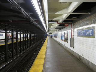
The First Avenue station is a station on the BMT Canarsie Line of the New York City Subway. Located at the intersection of First Avenue and East 14th Street at the border of Stuyvesant Park, Stuyvesant Town, and the East Village in Manhattan, it is served by the L train at all times.

The Baltimore Metro SubwayLink is a rapid transit line serving Baltimore, Maryland, and its northwestern suburbs, operated by the Maryland Transit Administration. The segment in Downtown Baltimore is underground, while most of the line outside the central city is elevated or at surface grade. In 2023, the line had a ridership of 1,988,300, or about 7,953 per weekday as of the fourth quarter of 2023.

The Baltimore Light RailLink is a light rail system serving Baltimore, Maryland, United States, and its northern and southern suburbs. It is operated by the Maryland Transit Administration. In downtown Baltimore, it uses city streets. Outside the central portions of the city, the line is built on private rights-of-way, mostly from the defunct Northern Central Railway, Baltimore and Annapolis Railroad and Washington, Baltimore and Annapolis Electric Railway. The system had a ridership of 3,546,300, or about 12,500 per weekday, as of the fourth quarter of 2023.

The Sheepshead Bay station is an express station on the BMT Brighton Line of the New York City Subway. It is located in the Sheepshead Bay neighborhood of Brooklyn. It is served by the Q train at all times and by the B train on weekdays.

The Lexington Avenue–63rd Street station is a New York City Subway station in Lenox Hill, Manhattan, shared by the IND and BMT 63rd Street Lines. Located at the intersection of Lexington Avenue and 63rd Street, it is served by the F and Q trains at all times; <F> trains during rush hours in the peak direction; limited rush hour N trains; and one A.M. rush hour R train in the northbound direction only.

Mondawmin station is a Metro SubwayLink station in Baltimore, Maryland. It is located under the intersection of Reisterstown Road and Liberty Heights Avenue in the Mondawmin neighborhood, adjacent to the Mondawmin Mall. It is the northernmost underground station on the line, and a major transfer point to many bus routes.

Reisterstown Plaza station is a Metro SubwayLink station in Baltimore, Maryland. It is located at the intersection of Patterson and Wabash Avenues, and is the fourth most northern and western station on the line, with approximately 700 parking spaces.
Rogers Avenue station is a Metro SubwayLink station in Baltimore, Maryland. It is located in the Woodmere area, and is the fifth most northern and western station on the line, with approximately 900 parking spaces.
State Center station is an underground Baltimore Metro SubwayLink station in Baltimore, Maryland. It is a transit hub offering connections to the Baltimore Light RailLink system, the tenth most northern and western station on the line, the first one in the area viewed by many as "downtown Baltimore," and is within a 2 block walk of the Cultural Center station on the Light RailLink syste, via Preston Street, and many area landmarks.

Charles Center station is an underground 2 floor Metro SubwayLink station in Baltimore, Maryland making it the largest station on the line. Located at the Charles Center in Downtown Baltimore, it is a downtown transportation hub serving many bus lines, nearby various landmarks, and bus transfers. It was the final stop of the line until 1995, when the extension to Johns Hopkins Hospital opened. The station is in close proximity to CFG Bank Arena as well as the Baltimore Arena station on the Light RailLink. The station has two street level entrances via escalators and elevators and is the center most station on the line serving Central Downtown Baltimore.

Shot Tower station is an underground Metro SubwayLink station in Baltimore, Maryland. It is in the central part of the city, in close proximity to many well-known landmarks, including the Shot Tower for which it is named, Port Discovery, Power Plant Live!, the Harbor campus of Baltimore City Community College, the National Aquarium, the Flag House, and Little Italy. The station has two street-level entrances, but unlike other Baltimore Metro stations that do, both these entrances share a common gate inside the station. The Shot Tower station is one of two stops in the third phase of the Baltimore Metro, having opened in 1995. Originally named Shot Tower/Market Place to showcase the proximity to the Market Place development, MTA Maryland dropped Market Place from its title with the 2017 rebranding of BaltimoreLink.

Johns Hopkins Hospital station is an underground Metro SubwayLink station in Baltimore, Maryland. It is located by Johns Hopkins Hospital, and is the final stop on the line.

Route 51 is a bus route operated by the Maryland Transit Administration in Baltimore and its suburbs. The line currently runs from the Rogers Avenue Metro Subway Station to the Patapsco Light Rail Stop, serving the communities of Arlington, Ashburton, Mondawmin, Rosemont, Baltimore, Cherry Hill, and Mt. Winans, and the suburb of Baltimore Highlands.

Lexington Market station is a Baltimore Light RailLink station adjacent to Lexington Market in Baltimore, Maryland. The station has two side platforms on the sidewalks of Howard Street. Lexington Market station on the Baltimore Metro SubwayLink is located one block to the west.
UMBC Transit is the official bus system of the University of Maryland, Baltimore County. Along with the Maryland Transit Administration (MTA), the UMBC community has public transit access to nearby areas such as Catonsville, Arbutus, Maryland, and Baltimore City.


