
The Maryland Transit Administration (MTA) is a state-operated mass transit administration in Maryland, and is part of the Maryland Department of Transportation. The MTA operates a comprehensive transit system throughout the Baltimore-Washington Metropolitan Area. There are 80 bus lines serving Baltimore's public transportation needs, along with other services that include the Light Rail, Metro Subway, and MARC Train. With nearly half the population of Baltimore residents lacking access to a car, the MTA is an important part of the regional transit picture. The system has many connections to other transit agencies of Central Maryland, Washington, D.C., Northern Virginia, and south-central Pennsylvania : WMATA, Charm City Circulator, Regional Transportation Agency of Central Maryland, Annapolis Transit, Rabbit Transit, Ride-On, and TransIT.

Route 1 is a bus route operated by the Maryland Transit Administration in Baltimore. The line currently runs from Fort McHenry to Sinai Hospital, with some trips making short turns at the Mondawmin Metro Subway Station. The bus route is the successor to the 1 Gilmor Street, 2 Carey Street, and 2 Fort Avenue streetcar lines.
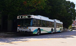
Route 91 is a bus route operated by the Maryland Transit Administration in Baltimore. The line currently runs from Sinai Hospital to City Hall, serving the communities of Pimlico, Arlington, Walbrook, and Bolton Hill, Coppin State College and the corridors of Garrison Boulevard and Eutaw Place. The line has the second-highest farebox recovery rate of all MTA bus lines.
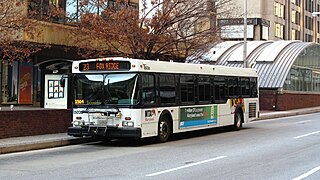
Route 23 is a bus route operated by the Maryland Transit Administration in Baltimore and its suburbs. The line currently runs from the Wal-Mart parking lot in Catonsville, Maryland east through downtown Baltimore to the Fox Ridge community in Essex, serving the corridors of Edmondson Avenue on the west side and Eastern Avenue on the east, and the communities of Edmondson Village, Allendale, Rosemont, Patterson Park, and Eastpoint, and is one of the most heavily used bus routes operated by the MTA.

Route 7 was a bus route operated by the Maryland Transit Administration in Baltimore. The line, which operated between 1959 and 2017, ran from Canton, Baltimore to the Mondawmin Metro Subway Station, serving the communities of Butcher's Hill, Little Italy, and Sandtown-Winchester.
Route 13 is a bus route operated by the Maryland Transit Administration in Baltimore. The line currently runs from Walbrook Junction in West Baltimore to Canton, mostly along North Avenue. The line has two main branches, both operating to Canton: one that operates via Fells Point and the other via Linwood and East Streets. Both these branches serve Johns Hopkins Hospital. Additionally, selected trips on weekdays and Saturdays operate to the block of Milton Avenue, Federal Street, and Patterson Park Avenue.
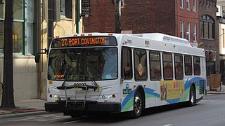
Route 27 is a bus route operated by the Maryland Transit Administration in Baltimore. The line currently runs from the Reisterstown Plaza Metro Subway Station in northwest Baltimore to Port Covington in South Baltimore through downtown. The line also serves the communities of Pimlico, Mt. Washington, Cross Keys, Hampden, and Cherry Hill, and the Greyhound bus terminal. The bus route is the successor to the 10 Roland Park, 12 Westport, and 25 Mount Washington streetcar lines.
Route 20 is a bus route operated by the Maryland Transit Administration in Baltimore and its suburbs. The line currently runs from Security Square Mall east through downtown Baltimore to Baltimore City Hall. The main roads on which the line operates are Old Frederick Road, Baltimore Street, Fayette Street, and Boston Street. The line serves the communities of Westview, Edmondson Village.

Route 35 is a bus route operated by the Maryland Transit Administration in Baltimore and its suburbs. The line currently runs from White Marsh Mall to UMBC through the city of Baltimore, with selected peak hour trips to Landsdowne. The line serves the Essex campus of the Community College of Baltimore County, the corridors of Philadelphia Road, Pulaski Highway, Monument Street, and Wilkens Avenue, the communities of Rosedale, East Baltimore, Southwest Baltimore, Elm Ridge, and Arbutus, and several Metro stations.

The United Railways and Electric Company was a street railway company in the Baltimore Metropolitan Area of the U.S. state of Maryland from 1899 to 1935.

The Maryland Transit Administration was originally known as the Baltimore Metropolitan Transit Authority, then the Maryland Mass Transit Administration before it changed to its current name in October 2001. The MTA took over the operations of the old Baltimore Transit Company on April 30, 1970.

LocalLink 29 is a bus route operated by the Maryland Transit Administration in Baltimore. The line currently runs from the Mondawmin Metro Subway Station in Northwest Baltimore to Brooklyn Homes in South Baltimore through the communities of Rosemont and the corridors of Hilton Street, Caton Avenue, and Patapsco Avenue. During peak hours, selected trips operate via Violetville Industrial Park.

Route 44 is a bus route operated by the Maryland Transit Administration in Baltimore and its suburbs. The line currently runs from Rosedale Industrial Park near Pulaski Highway just outside the Baltimore city limits on the east side of the city across the northern portion of the city to Security Square Mall, with selected peak hour trips to the Social Security Administration. Some early morning trips before 7 AM lay over at the Centers for Medicare and Medicaid Services (CMS) headquarters. The line operates mostly along Frankford Avenue, Echodale Avenue, East Belvedere Avenue, Northern Parkway, Rogers Avenue, and Gwynn Oak Avenue, serving the communities of Gardenville, Hamilton, Belvedere Park, Homeland, Roland Park, Pimlico, and Arlington, and the western suburb of Woodlawn.

Route 58 is a bus route operated by the Maryland Transit Administration in Baltimore and its suburbs. The line's western terminus is the Reisterstown Plaza Metro Subway Station, and its eastern terminus is White Marsh Mall, though some peak hour trips make short turns in Overlea. Route 58 serves the communities of Glen, Cheswolde, Fallstaff, a large section of Northern Parkway, and a portion of Belair Road in Baltimore County.

LocalLink 62 is a bus route in the suburbs of Baltimore. The line currently runs from the Essex campus of the Community College of Baltimore County to Turner's Station in Dundalk. The current route serves the Rosedale, Middle River, and Essex areas and the CCBC Essex and Dundalk campuses. The line was previously known as Route 4 prior to the launch of BalitmoreLink. LocalLink Route 62 replaced the entirety of Route 4 on June 18, 2017.

Route 47 is a limited stop bus route, identified as a "Quickbus", operated by the Maryland Transit Administration in Baltimore. The line currently runs from the Overlea Loop in Northeast Baltimore to Walbrook Junction, in West Baltimore. Service operates every 15 minutes during rush hour only. The main roads on which it operates include Poplar Grove Street, Saratoga Street, Gay Street, and Belair Road. Service operates Monday–Friday, every 15 minutes, from 5:30 a.m.– 9:30 a.m. and 2:30 p.m.- 6:30 p.m.
Mount Holly is a neighborhood in the Southwest District of Baltimore, located between the neighborhoods of Fairmont (south), Walbrook (east) and Garwyn Oaks (north). Its boundaries are drawn by Denison Street (east), Clifton Avenue (southwest), Gwynns Falls Parkway (north), Windsor Mill Road (northwest), and West North Avenue (south). Gwynns Falls Leakin Park is located to the west of Mount Holly.
CityLink Brown (BR) is a bus route operated by the Maryland Transit Administration between Downtown Baltimore City, and Overlea, Baltimore County, or White Marsh, Baltimore County. Northbound trips on the route depart from University of Maryland Medical Center, at the intersection of South Greene Street and West Pratt Street in Downtown Baltimore, and terminate at either the intersection of Belair Road and East Overlea Avenue just outside the eastern Baltimore City boundary, or at the White Marsh Mall Park & Ride. The northern terminal stop alternates throughout the day, and late night service only runs to Overlea. Southbound trips run between the same terminal stops in reverse; likewise, they depart either from White Marsh or Overlea.
