Urban development in the 1970s essentially cut Gay Street in half in east Baltimore. Old Town Mall, a retail strip that spans from Orleans to Aisquith and Monument Streets, was converted from a working street to a pedestrian mall. The street from that point north to Chase Street was essentially paved over, and the land was fitted into the surrounding street grid. Despite the rebuild, there are still a few housing units in the area that still follow the angular path that Gay Street cut through the neighborhood. Just north of Monument Street next to the Cain athletic field, there is a well-worn pedestrian path that follows the old route of Gay Street in defiance of the grass and meandering concrete sidewalk that borders the park.
Gay Street continues north from Chase, is briefly cut by the recently rebuilt (2000s) median of Broadway, then continues up to (and ends at) North Avenue, also known as U.S. Route 1 and U.S. Route 40 Truck through Baltimore city.
Interstate 83 (I-83) is an Interstate Highway in the Eastern United States. Its southern terminus is in Baltimore, Maryland at a signalized intersection with Fayette Street; its northern terminus is in Harrisburg, Pennsylvania at I-81.
Mount Vernon is a neighborhood immediately north of downtown Baltimore, Maryland. Designated a National Historic Landmark District and a city Cultural District, it is one of the city's oldest neighborhoods and originally was home to the city's most wealthy and fashionable families. The name derives from the Mount Vernon home of George Washington; the original Washington Monument, a massive pillar commenced in 1815 to commemorate the first president of the United States, is the defining feature of the neighborhood.
Mondawmin is a neighborhood located in the city of Baltimore, Maryland, United States. The neighborhood is surrounded by Druid Hill Park, the Whitelock Community, and Lower Park Heights. Included within its boundaries are Frederick Douglass High School, and Mondawmin Mall. The Baltimore Metro Subway serves the neighborhood, with a station at Mondawmin Mall that is also a hub for many bus routes.
Maryland Route 150 (MD 150) is a state highway in the U.S. state of Maryland. Known for most of its length as either Eastern Avenue or Eastern Boulevard, the highway runs 13.01 miles (20.94 km) from U.S. Route 40 (US 40) in Baltimore east to Graces Quarters Road in Chase in eastern Baltimore County. MD 150 connects Baltimore with its southeastern suburbs of Dundalk, Essex, and Middle River. The state highway also links those communities with Interstate 95, I-695, I-895, and Martin State Airport. MD 150 was constructed from Baltimore to Middle River and in Chase in the mid-1920s. The road was completed through Middle River in the early 1930s. Between 1942 and 1944, MD 150 was reconstructed as a four-lane divided highway with interchanges to improve access between Baltimore and the Glenn L. Martin Company aircraft manufacturing plant in Middle River. The highway has followed several routes since it was extended west into the city of Baltimore in the mid-1940s; the present route in East Baltimore was established shortly after 2000.
Kresson is a neighborhood of Southeast Baltimore, Maryland, United States.
The Ma and Pa Trail is a 6.25-mile (10.1 km) multi-purpose rail trail that follows the path of the old Ma and Pa Railroad through Harford County, Maryland. It contains three linked trails, one unconnected, with plans to bridge the gap in the middle, bringing the total length to 10 miles (16 km). Both links of the trail are paved, have few steep hills or hazards, and contain overlooks and bridges when necessary.
Otterbein is a small neighborhood of historic rowhouses in Baltimore, Maryland, United States. Otterbein is immediately southwest of, and in close walking distance to, the Inner Harbor. The neighborhood is very compact, entirely located between Hanover Street and Sharp Street, and between Barre Street and Henrietta Street. It is in small parts of zip codes 21201 and 21230. It is named for Old Otterbein Church, located immediately north of the neighborhood.
Middle East is a neighborhood in the heart of East Baltimore, Maryland.
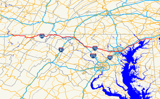
U.S. Route 40 in the U.S. state of Maryland runs from western Maryland to Cecil County in the state's northeastern corner. With a total length of 221 miles (356 km), it is the longest numbered highway in Maryland. Almost half of the road overlaps or parallels with Interstate 68 (I-68) or I-70, while the old alignment is generally known as US 40 Alternate, US 40 Scenic, or Maryland Route 144. West of Baltimore, in the Piedmont and Appalachian Mountains / Blue Ridge region of the Western Maryland panhandle of the small state, the portions where it does not overlap an Interstate highway are mostly two-lane roads. The portion northeast of Baltimore going to Wilmington, in northern Delaware and Philadelphia in southeastern Pennsylvania before crossing the Susquehanna River at the north end of the Chesapeake Bay, is a four-lane divided highway, known as the Pulaski Highway.
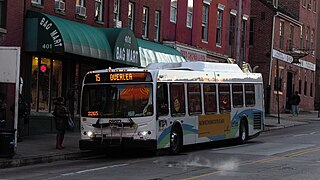
Route 15 is a bus route operated by the Maryland Transit Administration in Baltimore and its suburbs. The line currently runs from Security Square Mall, Westview Mall, Windsor Hills, or Walbrook Junction through downtown Baltimore and northeast to Overlea, with selected peak hour express trips to Perry Hall. The main roads on which it operates include Security Boulevard, Windsor Mill Road, Forest Park Avenue, Poplar Grove Street, Edmondson Avenue, Saratoga Street, Gay Street, and Belair Road, and is one of the most heavily used bus routes operated by the MTA.
Pratt Street is a major street in Baltimore. It forms a one-way pair of streets with Lombard Street that run west–east through downtown Baltimore. For most of their route, Pratt Street is one-way in an eastbound direction, and Lombard Street is one way westbound. Both streets begin in west Baltimore at Frederick Avenue and end in Butcher's Hill at Patterson Park Avenue. Since 2005, these streets have been open to two-way traffic from Broadway until their end at Patterson Park. Although Lombard is also a two-way street from Fulton Avenue to Martin Luther King Jr. Boulevard, Pratt is still one-way eastbound in this area.
St. Paul Street and Calvert Street are a one-way pair of streets in Downtown Baltimore and areas north. The streets, which are part of Maryland Route 2, are two of Baltimore's best-known streets in the downtown area.
Eutaw Street is a major street in Baltimore, Maryland, mostly within the downtown area. Outside of downtown, it is mostly known as Eutaw Place.
Shot Tower station is a Metro SubwayLink station in Baltimore, Maryland. It is in the central part of the city, in close proximity to many well-known landmarks, including the Shot Tower for which it is named, Port Discovery, Power Plant Live!, the Harbor campus of Baltimore City Community College, the National Aquarium, the Flag House, and Little Italy. The station has two street-level entrances, but unlike other Baltimore Metro stations that do, both these entrances share a common gate inside the station. The Shot Tower station is one of two stops in the third phase of the Baltimore Metro, having opened in 1995. Originally named Shot Tower/Market Place to showcase the proximity to the Market Place development, MTA Maryland dropped Market Place from its title with the 2017 rebranding of BaltimoreLink.
Jonestown is a neighborhood in the southeastern district of Baltimore. Its boundaries are the north side of Pratt Street, the west side of Central Avenue, the east side of Fallsway, and the south side of Orleans Street. The neighborhood lies north of the Little Italy, south of the Old Town, west of the Washington Hill, and east of the Downtown Baltimore neighborhoods. The southern terminus of the Jones Falls Expressway is located here.
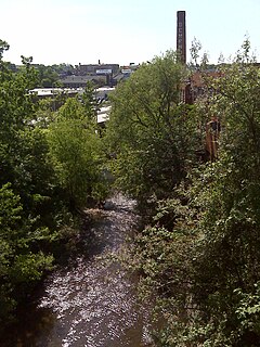
The Jones Falls is a 17.9-mile-long (28.8 km) stream in Maryland. It is impounded to create Lake Roland before running through the city of Baltimore and finally emptying into the Baltimore Inner Harbor.
Mercy Medical Center is a hospital located in Baltimore, Maryland. Mercy has been recognized as the #2 hospital in the State of Maryland for 2014-15 by U.S. News & World Report.
The Baltimore City Heritage Walk is a heritage trail that links 20 historic sites and museums in downtown Baltimore, Maryland.
The Orchards is a neighborhood in the North District of Baltimore, located between the neighborhoods of New North Roland Park–Poplar Hill and Bellona–Gittings. Its boundaries are marked by the Baltimore County line (north), Maryland Route 133 Northern Parkway (south), and Maryland Route 139 Charles Street (east). Roland Avenue, West Lake Avenue, Kenmore Road and Melrose Avenue draw the neighborhood's west boundary.
Penn-North is a neighborhood in the city of Baltimore, Maryland, United States. It is located southwest of Druid Hill Park, west of Reservoir Hill, north of Bolton Hill, and east of Mondawmin. It is bounded Northeast by the Druid Park Lake Drive, the West and Northwest by Fulton Ave., the South by North Avenue, and East by McCulloh Street. It is contained in the 21217 ZIP code.
This page is based on this Wikipedia article Text is available under the CC BY-SA 4.0 license; additional terms may apply. Images, videos and audio are available under their respective licenses.