Harborplace is a shopping complex on the Inner Harbor in Baltimore, Maryland.
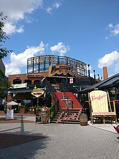
Power Plant Live! is a collection of bars, restaurants and other businesses in the Inner Harbor section of downtown Baltimore, Maryland. It was developed by The Cordish Companies and opened in phases during 2001, 2002, and 2003. The entertainment complex gets its name from the nearby "Power Plant" building, three blocks south on municipal Pier 4 on East Pratt Street facing the Inner Harbor, which was also later re-developed by Cordish.

Mondawmin is a neighborhood located in the city of Baltimore, Maryland, United States. The neighborhood is surrounded by Druid Hill Park, the Whitelock Community, and Lower Park Heights. Included within its boundaries are Frederick Douglass High School, and Mondawmin Mall. The Baltimore Metro Subway serves the neighborhood, with a station at Mondawmin Mall that is also a hub for many bus routes.

Read's Drug Store was a chain of stores based in Baltimore, Maryland. Read's Drug Store was founded by William Read. He sold it to the Nattans family in 1899. The downtown store was constructed in 1934 by Smith & May, Baltimore architects also responsible for the Bank of America building at 10 Light St. In 1929, one company slogan was "Run Right to Reads." Read's was purchased from the Nattans by Rite Aid in 1983.

Union Square is a neighborhood located in the Sowebo area of Baltimore. It dates to the 1830s and includes a historic district of houses and commerce buildings.

10 Inner Harbor is a cancelled skyscraper project in downtown Baltimore at a site overlooking the Inner Harbor at the corner of Light Street and West Conway Street. Currently, this land is a parking lot, and earlier still it was a McCormick & Co. spice lot.

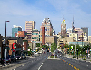
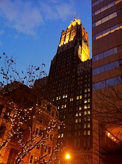
Transamerica Tower and originally built as the "USF&G Building", serving as headquarters of the United States Fidelity and Guarantee Company, a specialized insurance company founded in Baltimore in 1896, and relocated here from its former complex of three adjoining early 20th Century masonry structures at the southwest corner of South Calvert and Redwood Streets. Later occupied by and known as the Legg-Mason Building, it is a 40-story, 161 m (528 ft) skyscraper completed in 1973 in downtown Baltimore, Maryland at 100 Light Street on the city block bounded by South Charles, East Lombard, Light and East Pratt Streets, facing the former "The Basin" of the Helen Delich Bentley Port of Baltimore on the Northwest Branch of the Patapsco River and the newly iconic Inner Harbor downtown business waterfront redevelopment of the 1970s-80's era.
St. Paul Street and Calvert Street are a one-way pair of streets in Downtown Baltimore and areas north. The streets, which are part of Maryland Route 2, are two of Baltimore's best-known streets in the downtown area.
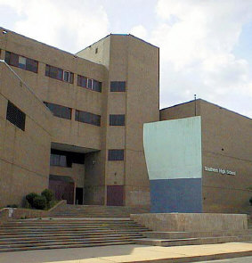
Southern High School was a former public secondary school on Warren Avenue between William Street to the west and Riverside Avenue to the east, in the Federal Hill neighborhood of the northern side of the larger old South Baltimore community on the Whetstone Point peninsula. With historic Fort McHenry from the War of 1812 (1812-1815), to the southeast at the point itself and additional residential areas surrounding the high school in tightly packed rowhouses and streets known as Locust Point and Riverside to the south and southeast along with the restored Otterbein and Sharp-Leadenhall neighborhoods to the west, also just south of the downtown central business district and famed "Inner Harbor" of the City of Baltimore, in Maryland.
Ford's Grand Opera House was a major music venue in Baltimore, Maryland, located on West Fayette Street between North Howard and Eutaw Streets. It was founded by theatre manager John T. Ford and designed by architect James J. Gifford. The opera house/theatre opened to the public on October 2, 1871 with a show that included readings from Shakespeare's "As You Like It" as well as vocal and orchestral performances. Then owned by 1950s–60s era theatre magnate Morris A. Mechanic, it closed almost 93 years later with its last Broadway show from New York City, "Something Funny Happened on the Way to the Forum" in 1964. It was replaced three years later as the prime site for Baltimore live theatre patrons with the opening in the landmark of the new downtown redevelopment project of Charles Center, the starkly modernistic "Brutalist" architecture of the Morris A. Mechanic Theatre at the southwest corner of Charles and Baltimore Streets, four blocks to the east.
300 East Pratt Street was a proposed hotel in Baltimore, Maryland. The building was originally expected to rise 640 feet (200 m). Construction of the building was to begin in 2007 and was expected to be completed in 2010. The construction of this building was proposed in 2003, though, it was never approved by the state of Maryland. In 2006, the construction of the building was again proposed, and finally approved by the state of Maryland. The building is being built where the Hearst Production Building once stood. Plans are now scaled back to 40 stories and 300,000 square feet of office space, in addition to a 270-room hotel. 300 East Pratt Street is located in Baltimore, MD between Commerce and South streets, housed the former Baltimore News-American building. It has been vacant and used for a parking lot for decades. However, parking lot owner InterPark LLC purchased the site in August 2013 after a redevelopment plan proposed by Urban America LP in 2006 fell apart during the recession.

100 East Pratt Street is a building located on Pratt Street in the Inner Harbor district of Baltimore, Maryland that consists of a ten-story concrete building finished in 1975 and a 1991 glass and steel twenty-eight story tower.

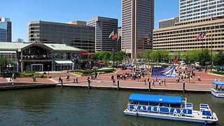
Inner Harbor East, now more recently referred to more commonly as simply as Harbor East, is a relatively new mixed-use development project in Baltimore, Maryland, United States along the northern shoreline of the Northwest Branch of the Patapsco River, which is the Baltimore Harbor, and its Inner Harbor. Major tenants of Harbor East include the Baltimore Marriott Waterfront Hotel on Aliceanna Street, between the Waterfront Promenade on the west and to the east is the President Street Boulevard and the Katyn Forest Massacre Memorial (monument) in the International Drive circle at the south end.. Also, the new Legg Mason Tower, in which the famous financial services firm moved from the central downtown is located across the street. A Four Seasons Hotel opened in November 2011.
"David A. Wallace, FAICP, AIA, PP" was an influential urban planner and architect who founded the firm of Wallace Roberts & Todd (WRT) with Ian McHarg.

The Pratt Street Power Plant — also known as the Pier Four Power Plant, The Power Plant, "Pratt Street Toenail", and Pratt Street Station — is a historic former power plant located in downtown Baltimore, Maryland, USA. It has undergone significant repurposing development since retirement and was listed on the National Register of Historic Places in 1987.
Charles Center is a large-scale urban redevelopment project in central Baltimore's downtown business district of the late 1950s and early 1960s. Beginning in 1954, a group called the "Committee for Downtown" promoted a master plan for arresting the commercial decline of central Baltimore. In 1955, the "Greater Baltimore Committee", headed by banker and developer James W. Rouse, joined the effort. A plan was developed by noted American urban planner and architect David A. Wallace, (1917−2004), strongly supported by Mayors Thomas L. J. D'Alesandro, Jr. (1947−1959) and Theodore R. McKeldin, and many in their administrations, which formed the basis of a $25 million bond issue voted on by the citizens of Baltimore City in during the municipal elections in November 1958. The architects' view of the overall Charles Center Redevelopment Plan with the conceptions of possible buildings, lay-out and plan that was publicized to the voters that spring and summer before, only slightly resembles the actual buildings and designs that later were really constructed by the mid-1970s.
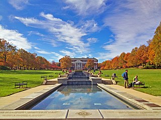
McKeldin Mall is a nine-acre quad in the heart of the campus of the University of Maryland, College Park. Named after Theodore McKeldin, the former Governor of Maryland, McKeldin Mall is the largest academic mall in the United States. It has been named one of the most picturesque college campus quads in the nation.