Baltimore Light RailLink

Last updated

Light RailLink
Baltimore Light RailLink logo.svg
BaltimoreLightRail.JPG
A train at Convention Center station in 2010
Overview
Locale Baltimore, Maryland, United States
Transit type Light rail
Number of lines3
Number of stations33
Daily ridership12,500 (weekdays, Q4 2023) [1]
Annual ridership3,546,300 (2023) [2]
Operation
Began operationApril 1992
Operator(s) Maryland Transit Administration
Technical
System length30 mi (48.3 km)
Track gauge 4 ft 8+12 in (1,435 mm) standard gauge
Minimum radius of curvature 100 ft (30 m)
Electrification Overhead line,  750 V DC
System map
Baltimore Light RailLink Light RailLink highlighted in blue
BSicon uKHSTa.svg
Hunt Valley
BSicon PARKING.svg
BSicon uHST.svg
Pepper Road
BSicon uHST.svg
McCormick Road
BSicon uHST.svg
Gilroy Road
BSicon uHST.svg
Warren Road
BSicon PARKING.svg
BSicon uPSLa.svg
Texas (short turn)
BSicon uHST.svg
Fairgrounds
BSicon PARKING.svg
BSicon uHST.svg
Timonium
BSicon uHST.svg
Lutherville
BSicon PARKING.svg
BSicon uhbKRZWae.svg
BSicon uHST.svg
Falls Road
BSicon PARKING.svg
BSicon uHST.svg
Mt. Washington
BSicon PARKING.svg
BSicon uHST.svg
Cold Spring Lane
BSicon uHST.svg
Woodberry
BSicon uYRDeq.svg
BSicon uABZg+r.svg
Yard and shops
BSicon uHST.svg
North Avenue
BSicon PARKING.svg
BSicon uABZg+l.svg
BSicon uKINTeq.svg
Penn Station
BSicon LOGO Amtrak2.svg MARC train.svg
BSicon uHST.svg
Mt. Royal/MICA
BSicon uINT.svg
Cultural Center
Baltimore Metro SubwayLink Logo for Signage (Blue).svg
BSicon uHST.svg
Mt. Vernon
BSicon uINT.svg
Lexington Market
Baltimore Metro SubwayLink Logo for Signage (Blue).svg
BSicon uHST.svg
Baltimore Arena
BSicon uHST.svg
Convention Center
BSicon uINT.svg
Camden Yards
MARC train.svg
BSicon uHST.svg
Stadium/Federal Hill
BSicon uhbKRZWae.svg
BSicon uHST.svg
Westport
BSicon uHST.svg
Cherry Hill
BSicon uHST.svg
Patapsco
BSicon PARKING.svg
BSicon uHST.svg
Baltimore Highlands
BSicon PARKING.svg
BSicon uhbKRZWae.svg
BSicon uHST.svg
Nursery Road
BSicon PARKING.svg
BSicon uHST.svg
North Linthicum
BSicon PARKING.svg
BSicon uHST.svg
Linthicum
BSicon uHST+l.svg
BSicon uABZgr.svg
BWI Business District
BSicon PARKING.svg
BSicon uKINTe.svg
BSicon uSTR.svg
BWI Airport
BSicon FLUG.svg
BSicon uHST.svg
Ferndale
BSicon uKHSTe.svg
Glen Burnie
BSicon PARKING.svg

Wheelchair symbol.svg All stations are accessible

The Baltimore Light RailLink (formerly Baltimore Light Rail, also known simply as the "Light Rail") is a light rail system serving Baltimore, Maryland, United States, and its northern and southern suburbs. It is operated by the Maryland Transit Administration (MTA Maryland). In downtown Baltimore, it uses city streets. Outside the central portions of the city, the line is built on private rights-of-way, mostly from the defunct Northern Central Railway, Baltimore and Annapolis Railroad and Washington, Baltimore and Annapolis Electric Railway. The system had a ridership of 3,546,300, or about 12,500 per weekday, as of the fourth quarter of 2023.

Contents

History

Initial segment

Hunt Valley, the terminus of the 5-station northern extension opened in 1997, pictured here in 2014 Train arriving at Hunt Valley station, August 2014.JPG
Hunt Valley, the terminus of the 5-station northern extension opened in 1997, pictured here in 2014
Construction work in progress in June 2003 to add a second track to the bridge over the Middle Branch of the Patapsco River Double tracking of Baltimore Light Rail bridge, June 2003.jpg
Construction work in progress in June 2003 to add a second track to the bridge over the Middle Branch of the Patapsco River

The origins of the Light RailLink lie in a 1966 Baltimore area transit plan that envisioned six rapid transit lines radiating from the city center. By 1983, only one of the plan's lines—the "Northwest" line—had been built, becoming the Metro SubwayLink. Much of the plan's "North" and "South" lines ran along rights-of-way once used by interurban streetcar lines and the commuter rail routes of the Northern Central Railway, Washington, Baltimore and Annapolis Electric Railway, and Baltimore and Annapolis Railroad.

Beginning in the late 1980s, Governor of Maryland and former Baltimore mayor William Donald Schaefer pushed for a transit line along the plan's "North" and "South" corridors, motivated in part by a desire to establish a rail transit link to the new baseball park being built at Camden Yards for the Baltimore Orioles. Light RailLink was built quickly and inexpensively without federal funds, a rarity for a U.S. transit project. The initial system was a single 22.5-mile (36.2 km) line, all at-grade except for a bridge over the Middle Branch of the Patapsco River just south of downtown Baltimore. The line ran from Timonium in Baltimore County in the north to Glen Burnie in Anne Arundel County in the south.

The line opened in stages over a 14-month period. The initial segment from Timonium Fairgrounds station (now Fairgrounds station) to Camden Yards station opened for limited service for Orioles games on April 2, 1992, and for full service on May 17. [3] [4] A three-station extension to Patapsco opened on August 20, 1992, followed by a 4-station extension to Linthicum on April 2, 1993, and an additional 2-station extension to Glen Burnie on May 20, 1993. [3] [4]

Station placement and design were intended to be flexible and change over time, as stations could be built or closed at low cost.[ citation needed ] However, they were at times dictated by politics rather planning: proposed stops in Ruxton, Riderwood, and Cross Keys were not built due to local opposition, while Mt. Royal station (now Mt. Royal/MICA station) and Timonium Business Park station (now Timonium station) were built despite nearly being removed from the plan because the University of Baltimore and a local business group funded them. Falls Road station was built with less parking than ridership required because community requests and a fence prevented riders from accessing a nearby commercial building. [5]

Expansion

Three extensions to the system were added in 1997. On September 9, the line was extended north 4.5 miles (7.2 km) to Hunt Valley, adding five stations that served a major business park and a mall. [6] On December 6, two short but important branches were added to the system: a 0.3-mile (0.48 km) spur in Baltimore that provided a link to the Penn Station intercity rail hub, and a 2.7-mile (4.3 km) spur to the terminal of BWI Airport. [6] [4]

On September 6, 1998, the Hamburg Street station (now Stadium/Federal Hill station) opened as an infill station between the existing Westport and Camden Yards stations. [7] [3] Adjacent to M&T Bank Stadium, it was initially only open during Ravens games and other major stadium events, but became a full-time stop on July 1, 2005. [4]

To save money, much of the system was built with only a single track. While this allowed the system to be constructed and opened quickly, it limited the system's flexibility: much of the line was restricted to 17-minute headways, with no way to reduce headways during peak hours. Federal money was acquired to double track most of the system; much of the line south of downtown Baltimore was shut down in 2004 and north of downtown shut down in 2005 in order to complete this project. The northern section up to Timonium reopened in December 2005; the rest opened in February 2006. The line north of Gilroy Road and the BWI Airport spur remain single tracked.

Incidents

On July 10, 2019, part of the northbound platform at Convention Center station fell into a sinkhole caused by a broken water main. [8] The line was closed between Camden and North Avenue until August 19. [9]

On December 7, 2023, MTA Maryland announced the system would shut down indefinitely after inspections revealed a fire hazard in the rolling stock. [10] A free shuttle bus service connected Light Rail stations as repairs were made to the 53-car fleet. [11] Service resumed on December 23. [12]

Operation

Routing and schedules

The Light RailLink system consists of a main north–south line on which 28 of the system's 33 stops are located. There are two branches on the southern end to BWI Airport and Glen Burnie that have two stations each and one spur in Baltimore City for Penn Station that can only be entered heading north and exited heading south. There are still single-track sections north of Timonium, where headways are limited to 15 minutes.

The Light RailLink system has two train runs. One runs the full length of the main line between Hunt Valley and either BWI Airport or Glen Burnie, alternating between the two every other trip, with some off-peak trains originating or terminating at either North Avenue or Fairgrounds instead of Hunt Valley. The other—the Penn-Camden Shuttle—only runs through downtown between Penn Station and Camden Station. [13]

The light rail operates from 4:00 a.m. to 12:45 a.m. on weekdays, 4:15 a.m. to 12:45 a.m. on Saturdays, and 10 a.m. to 10 p.m. on Sundays and major holidays. At peak hours on weekdays (from the first trains of the day until 10 a.m., and from 4 p.m. to 6 p.m.), the BWI–Hunt Valley and Glen Burnie–Fairgrounds routes see 20-minute headways; at other times on weekdays and all day on weekends, there are 30-minute headways on both routes (with Glen Burnie trains traveling all the way to Hunt Valley). The Camden Yards-Penn Station route sees 30-minute headways at all times. Because there is significant overlap on these routes, most of the system sees 10-minute peak and 15-minute off-peak headways; stations in the downtown section between Mt. Royal and Camden Yards are served by six trains an hour off-peak and eight trains an hour at peak. (Paradoxically, the Fairgrounds-Hunt Valley section actually sees longer headways at peak hours.)

Most of the light rail's route is on dedicated right-of-way that has grade crossings equipped with crossing gates. The remainder of the route in downtown Baltimore between Camden Station and Mt. Royal uses shared right of way on Howard Street, where trains mix with automobile traffic and their movement is controlled by traffic signals. In 2007, a transit signal priority system was implemented on this section, resulting in time savings of 25%. [14] From south of Falls Road to North Avenue, the light rail runs parallel to the Jones Falls Expressway, and from Camden Yards to north of Westport, it parallels Interstate 395. North of Falls Road and south of Westport, it follows its own path towards its respective termini.

The space mean speed between Hunt Valley and BWI, based on a scheduled running time of 1:20 and a distance of 30 miles (48 km), is about 22 miles per hour (35 km/h).

Fares and transit connections

MTA fares are identical for the Metro SubwayLink, Light RailLink, and local buses: a one-way trip costs $2.00. [15] Daily, weekly, and monthly unlimited-ride passes are also available that are good on all three transit modes. A passenger with a one-way ticket can change Light RailLink trains if necessary to complete their journey, the only instance of a one-way MTA ticket being good for a ride on more than one vehicle, but transferring to a bus or the Metro requires a new one-way fare or a pass. Automated ticket vending machines that sell tickets and passes are available at all Light RailLink stations.

The Light RailLink's ticketing is based on a proof-of-payment system. Passengers must have a ticket or pass before boarding. Maryland Transit Administration Police officers ride some trains and randomly check passengers to make sure that they are carrying a valid ticket or pass and can issue criminal citations for those without one. Civilian Fare Inspectors also conduct ticket checks, alighting those without fare.

Most Light RailLink stations are served by several MTA bus routes and passengers can make platform-to-platform transfers with the MARC Camden Line at Camden Yards and with the MARC Penn Line at Penn Station. There are no cross-platform connections with the Metro SubwayLink. The Lexington Market subway and light rail stations are a block apart and connected only via surface streets.

Ridership


Rolling stock

A typical two-car train at Lutherville station in 2014 Southbound train at Lutherville station, August 2014.JPG
A typical two-car train at Lutherville station in 2014

Baltimore's Light RailLink vehicles (LRVs) were built by ABB Traction, the U.S. division of ABB. The initial set was delivered in 1991–1992 as the line was being built; a supplemental order of similar cars built by AAI Corporation was delivered in 1997, when the extensions came into service.

Baltimore LRVs are larger than traditional streetcars and those used on San Francisco's Muni Metro or Boston's Green Line. The articulated cars are 95 feet (28.96 m) long over coupler faces, 9.5 feet (2.90 m) wide, and 12.5 feet (3.81 m) high, and can accommodate 85 seated and 91 standing passengers. The cars operate on 4 ft 8+12 in (1,435 mm) standard gauge track. One-, two- and three-car trains are all routinely seen in service. Trains are powered by 750 volt DC from overhead lines via a pantograph, and have a maximum speed of 60 miles per hour (97 km/h). When delivered, they were the first transit vehicles in the United States to employ A/C propulsion. Each LRV is powered by four 275 hp (205 kW) motors (1,100 hp or 820 kW total); the middle truck of three-car trains is unpowered.

Interior of a Baltimore Light RailLink vehicle Baltimore LRV interior.jpg
Interior of a Baltimore Light RailLink vehicle

As of 2024, the MTA had 53 individual light rail cars. During typical weekday peak-time service, approximately 30 to 35 cars are required; a somewhat higher number of cars are put into service immediately after Orioles and Ravens games. For weekday service, as well as days of Orioles games or events at the CFG Bank Arena or Baltimore Convention Center, trains going from Hunt Valley to Cromwell and BWI Airport are generally run with two cars, while three-car trains are put into service for Ravens games and major downtown events. The Penn Station-Camden Yards shuttle is typically operated with one-car trains. The MTA also owns a variety of maintenance of way equipment, which can use diesel power in emergencies.

A mid-life upgrade of the light rail vehicles began in 2013. [21] On September 9, 2013, a contract for mid-life overhauls of the light rail vehicles was awarded to Alstom. Five vehicles at a time were sent for rebuilding, involving testing, removal of all interior and exterior components and replacement with new propulsion systems. The overhaul is scheduled for completion in March 2018. [22] The overhauled cars began testing in early 2016. [23] By 2021 the original order of ABB vehicles had their interiors upgrades with security cameras, LED lighting, and LCD screens that show the train's position along the line.

Future

While there are several plans and proposals to expand the system, none are approved or funded. An independent commission on Baltimore-area transit made a number of suggestions in a 2002 report for new lines and expansions of existing lines. [24] Newer proposals include expanding service on the existing Central Light RailLink line by extending Sunday service via the BaltimoreLink plan, as well as new stations and spurs. [25]

Texas station

The incomplete Texas station in 2014 Platform at possible Texas station, August 2014.JPG
The incomplete Texas station in 2014

There are plans to add an infill station between the existing Timonium and Warren Road stations in Texas, Cockeysville. An island was built at this point on the line in conjunction with the 2005 double-tracking work to provide a turn-back point for trains not going all the way to Hunt Valley, which could be converted into a station at a later date.

Stockholm Street station

In the 2015 South Baltimore Gateway Masterplan, the city of Baltimore proposed a new light rail stop along the Central Light RailLink line at Stockholm Street, in between Hamburg Street and Westport. The new station would be located near a proposed new MARC station west of Russell Street, [26] and would provide additional access to the Baltimore Greyhound Bus Terminal, the Horseshoe Casino, and new businesses in the Carroll-Camden Industrial Area. [27]

Port Covington extension

In January 2016, plans were unveiled by Sagamore Development Company, owned by Under Armour CEO Kevin Plank, regarding the redevelopment of Port Covington in South Baltimore. [28] The new plan for Port Covington calls for two proposed new light rail stations, along with new residential and commercial development. The first station would be located west of Hanover Street, and the other would be located at the intersection of East McComas Street and East Cromwell Street, just south of Federal Hill. [29] This proposed extension would create a new spur from the Central Light RailLink line by crossing the Middle Branch of the Patapsco River south of Interstate 95.

Low floor vehicles

The MTA plans to transition the system from high floor vehicles to low floor LRVs and requested information from low-floor LRV vendors in January 2023. [30]

Red Line

The Red Line is a planned 14.1-mile (22.7 km), 19-station light rail line traveling east–west that would intersect with the existing Light RailLink downtown; [31] this would be a separate service, with no track connection to the existing Light RailLink, though there would be opportunities for transfer between the two in the vicinity of University Center / Baltimore Street. The line would operate in a total of 4.7-mile (7.6 km) of tunnels through the downtown area (and along Cooks Lane), with the majority of the rest of the system operating at-grade and just a few aerial sections, as well as in the median of the former Interstate 170 freeway. The Red Line was cancelled by Governor Larry Hogan, who had campaigned against it in the 2014 Maryland gubernatorial election, on June 25, 2015. [32] Wes Moore, his successor, indicated his intention to revive it shortly after being elected, and formally announced the return of the project in a ceremony with Baltimore mayor Brandon Scott on June 15, 2023, though it may be built as a bus rapid transit line instead of light rail. [33] [34] [35]

See also

Related Research Articles

<span class="mw-page-title-main">Maryland Transit Administration</span> Public transit authority of the state of Maryland

The Maryland Transit Administration (MTA) is a state-operated mass transit administration in Maryland, and is part of the Maryland Department of Transportation. The MTA operates a comprehensive transit system throughout the Washington-Baltimore metropolitan area. There are 80 bus lines serving the Baltimore Metropolitan Area, along with rail services that include the Light Rail, Metro Subway, and MARC Train. In 2023, the system had a ridership of 52,922,000, or about per weekday as of the fourth quarter of 2023.

<span class="mw-page-title-main">MARC Train</span> U.S. passenger rail system in Baltimore–Washington metropolitan area

MARC is a commuter rail system in the Washington–Baltimore area. MARC is administered by the Maryland Transit Administration (MTA) and operated under contract by Alstom and Amtrak on track owned by CSX Transportation (CSXT) and Amtrak. In 2023, the system had a ridership of 3,860,600, or about 12,400 per weekday as of the fourth quarter of 2023, less than pre-COVID-19 pandemic weekday ridership of 40,000.

<span class="mw-page-title-main">BWI Rail Station</span> Intermodal passenger station in Linthicum, Maryland

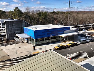
BWI Rail Station is an intermodal passenger station in Linthicum, Maryland near Baltimore/Washington International Airport (BWI). It is served by Amtrak Northeast Corridor intercity trains, MARC Penn Line regional rail trains, and several local bus lines.

<span class="mw-page-title-main">Green Line D branch</span> Light rail line

The Green Line D branch is a light rail line in Boston, Brookline, Cambridge, Newton, and Somerville, Massachusetts, operating as part of the Massachusetts Bay Transportation Authority (MBTA) Green Line. The line runs on a grade separated surface right-of-way for 9 miles (14 km) from Riverside station to Fenway station. The line merges into the C branch tunnel west of Kenmore, then follows the Boylston Street subway and Tremont Street subway to North Station. It is the longest and busiest of the four Green Line branches. As of February 2023, service operates on 8 to 9-minute headways at weekday peak hours and 8 to 11-minute headways at other times, using 13 to 19 trains.

<span class="mw-page-title-main">Baltimore Metro SubwayLink</span> Rapid transit line in Baltimore, Maryland, US

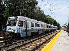
The Baltimore Metro SubwayLink is a rapid transit line serving Baltimore, Maryland, and its northwestern suburbs, operated by the Maryland Transit Administration. The segment in Downtown Baltimore is underground, while most of the line outside the central city is elevated or at surface grade. In 2023, the line had a ridership of 1,988,300, or about 7,953 per weekday as of the fourth quarter of 2023.

The Baltimore–Washington Superconducting Maglev Project (SCMAGLEV) is a proposed project connecting the United States cities of Baltimore, Maryland, and Washington, D.C., with a 40 miles (64 km) maglev train system between their respective central business districts. It is the first segment of the planned Washington-New York Northeast Maglev project. The maglev proposal is not related to the Baltimore–Washington hyperloop proposed by the Boring Company.

<span class="mw-page-title-main">Baltimore and Annapolis Railroad</span> Defunct railway line in Maryland, US

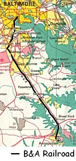
The Baltimore & Annapolis Railroad was an American railroad of central Maryland built in the 19th century. The railroad, the second to serve Annapolis, ran between Annapolis and Clifford along the north shore of the Severn River. From Clifford, just north of the present day Patapsco Light Rail Stop, it connected with the B&O's Curtis Bay branch so that trains could travel to Baltimore. In 1921, when it was called the Annapolis and Baltimore Short Line, it was purchased by the larger Washington, Baltimore and Annapolis Electric Railway (WB&A), and then emerged from the WB&A's 1935 bankruptcy and closure as the Baltimore & Annapolis Railroad. B&A electric passenger operation between the two cities continued until 1950, at which time the rail line became solely a freight carrier, operating buses for passenger service. Freight service to Annapolis continued until June 1968 when the Severn River Trestle was declared unsafe. In the 1980s, the line was completely shut down. The right-of-way now serves as part of Baltimore's light rail system and as the Baltimore & Annapolis Trail.

<span class="mw-page-title-main">LocalLink 93 (BaltimoreLink)</span> Bus route operated by the Maryland Transit Administration

LocalLink 93 is a bus route operated by the Maryland Transit Administration in the suburbs of Baltimore. The line currently runs from the Lutherville Light Rail Stop to International Circle near Hunt Valley Town Center, serving the Timonium and Cockeysville areas.

<span class="mw-page-title-main">LocalLink 70 (BaltimoreLink)</span> Bus route operated by the Maryland Transit Administration

LocalLink 70 is a bus route operated by the Maryland Transit Administration between Baltimore and Annapolis, Maryland. At most times, the line operates from the Patapsco light rail station in southern Baltimore County with short turns at Jumper's Hole in Pasadena. The bus route, one of the longest local routes operated by MTA, is the successor to the Baltimore and Annapolis Railroad interurban, and mainly operates along the parallel Ritchie Highway, serving Brooklyn Park, Glen Burnie, Pasadena, and Severna Park. When the Light Rail is not running, the 70 runs all the way to downtown Baltimore, mostly along Hanover Street.

<span class="mw-page-title-main">LocalLink 75 (BaltimoreLink)</span> Bus route operated by the Maryland Transit Administration

LocalLink 75 is a bus route operated by the Maryland Transit Administration in Baltimore and its suburbs. The line currently runs from the Patapsco Light Rail Stop to Arundel Mills in Anne Arundel County, via BWI Airport. The line operates to University of Maryland during hours when the light rail is not operating.

<span class="mw-page-title-main">Penn Line</span> MARC commuter rail service from Washington, D.C., to Perryville, Maryland

The Penn Line is a MARC passenger rail service operating between Union Station in Washington, D.C., and Perryville, Maryland, along the far southern leg of the Northeast Corridor; most trains terminate at Baltimore's Penn Station. It is MARC's only electrified line. However, a majority of trips remain diesel powered. With trains operating at speeds of up to 125 miles per hour (201 km/h), it is the fastest commuter rail line in the United States. The service is operated by Amtrak under contract to the Maryland Transit Administration. MARC sets the schedules, owns most of the stations, and controls fares, while Amtrak owns and maintains the right-of-way, supplies employees to operate trains, and maintains the rolling stock. It is the busiest of MARC's three lines, with twice as many trains and ridership as the Brunswick and Camden lines combined.

<span class="mw-page-title-main">VTA light rail</span> Light rail system in Santa Clara County, California

The VTA light rail system serves San Jose and nearby cities in Santa Clara County, California. It is operated by the Santa Clara Valley Transportation Authority, or VTA, and consists of 42.2 miles (67.9 km) of network comprising three main lines on standard gauge tracks. Originally opened on December 11, 1987, the light rail system has gradually expanded since then, and currently has 60 stations in operation.

<span class="mw-page-title-main">Camden Station</span> Rail station in Baltimore, Maryland, US

Camden Station, now also referred to as Camden Street Station, Camden Yards, and formally as the Transportation Center at Camden Yards, is a train station at the intersection of South Howard and West Camden Streets in Baltimore, Maryland, adjacent to Oriole Park at Camden Yards, behind the B&O Warehouse. It is served by MARC commuter rail service and local Light Rail trains.

<span class="mw-page-title-main">Fairgrounds station</span> Light rail station in Timonium, Maryland, US

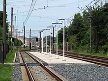
Fairgrounds station is a Baltimore Light RailLink station located adjacent to the Maryland State Fairgrounds in Timonium, Maryland. The station has two side platforms serving two tracks.

<span class="mw-page-title-main">Timonium station</span> Light rail station in Timonium, Maryland, US

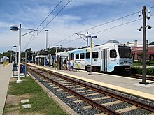
Timonium station is a Baltimore Light RailLink station in Timonium, Maryland. It opened as part of the system's initial operating segment in 1992. The station originally had a parking lot which was later removed. It has two side platforms serving two tracks.

<span class="mw-page-title-main">Route 29 (MTA Maryland)</span> Bus route operated by the Maryland Transit Administration

Route 29 was a bus route operated by the Maryland Transit Administration in Baltimore. The line operated on weekdays and Saturdays in a circular fashion, linking the Cherry Hill Light Rail Stop to the Cherry Hill community. Two other MTA bus lines, formerly the routes 27 and 51, also served the Cherry Hill area.

<span class="mw-page-title-main">Glen Burnie station</span> Baltimore Light RailLink station in Glen Burnie, Maryland

Glen Burnie station is a Baltimore Light RailLink station in Glen Burnie, Maryland. It is one of the system's two southern terminals, and one of two stations in Glen Burnie. Trains depart Glen Burnie bound for Fairgrounds station or Hunt Valley station. Unlike the nearby Ferndale station, there are currently 795 free parking spaces and connections can be made to MTA Maryland's Route 14 bus from here. South of the station, the lines terminate on an embankment on the northwest corner of Maryland Route 648 and Maryland Route 176 to the east of Interstate 97, and the right of way is replaced by the Baltimore and Annapolis Rail Trail.

The Yellow Line is a mass transit line proposed by the Baltimore Regional Rail Plan in March 2002 for the Baltimore, Maryland area. It would begin at Columbia Town Center in Columbia, Maryland, and end in Hunt Valley, Maryland at Shawan Road.

UMBC Transit is the official bus system of the University of Maryland, Baltimore County. Along with the Maryland Transit Administration (MTA), the UMBC community has public transit access to nearby areas such as Catonsville, Arbutus, Maryland, and Baltimore City.

References

  1. "Transit Ridership Report Fourth Quarter 2023" (PDF). American Public Transportation Association. March 4, 2024. Retrieved March 14, 2024.
  2. "Transit Ridership Report Fourth Quarter 2023" (PDF). American Public Transportation Association. March 4, 2024. Retrieved March 14, 2024.
  3. 1 2 3 Logan, Mary (December 1, 2005). "MAJOR TRANSPORTATION MILESTONES IN THE BALTIMORE REGION SINCE 1940" (PDF). Baltimore Metropolitan Council. p. 13. Archived from the original (PDF) on June 23, 2015. Retrieved October 24, 2017.
  4. 1 2 3 4 "House Bill 1185: Maryland Transit Administration – Public Transit Services – Efficiency and Performance Standards" (PDF). Department of Legislative Services, Maryland General Assembly. July 1, 2008. p. 4.
  5. Gunts, Edward (May 17, 1992). "Baltimore's light rail 'more than ready' to roll for regular service MTA says beauty of light-rail system is its flexibility". Baltimore Sun.
  6. 1 2 "Maryland Department of Transportation Maryland Transit Administration Media Guide" (PDF). Maryland Department of Transportation Maryland Transit Administration. 2017. pp. 15–16. Archived from the original (PDF) on April 12, 2018.
  7. Peckham, Geoff (September 6, 2008). "Stadium Celebrates 10-Year Anniversary" (Press release). Baltimore Ravens. Archived from the original on November 17, 2017. Retrieved November 17, 2017.
  8. Dance, Scott; Duncan, Ian; Reed, Lillian (July 10, 2019). "Large hole opens in downtown Baltimore street, swallowing part of Light Rail station; crews preparing for heavy rain Thursday". Baltimore Sun.
  9. Davis, Phil (August 18, 2019). "Light Rail service near Howard and Pratt Street sinkhole to resume Monday". Baltimore Sun.
  10. "MTA to suspend all Light Rail services effective Friday - CBS Baltimore". www.cbsnews.com. December 7, 2023. Retrieved December 7, 2023.
  11. Starkey, Josh (December 7, 2023). "Light rail services to be suspended starting Friday". WBAL. Retrieved December 7, 2023.
  12. Ng, Greg (December 23, 2023). "Back on track: Light Rail resumes Saturday following shutdown". WBAL. Retrieved December 29, 2023.
  13. "Light rail". Department of Transportation Maryland Transit Administration. Retrieved April 25, 2015.
  14. Reflections in Motion Archived February 7, 2009, at the Wayback Machine 2007 MTA Annual Report (PDF), page 12. Retrieved February 9, 2010.
  15. "Regular Fares". Maryland Transit Administration. Retrieved April 10, 2023.
  16. "Trends in Transit Annual Report 2011" (PDF). Maryland Transit Administration. p. 24. Retrieved April 25, 2015.
  17. "Transit Matters annual report AR12" (PDF). Maryland Transit Administration. p. 6. Retrieved April 25, 2015.
  18. "Forward Focus Annual Report 2013 A Year in Review" (PDF). Maryland Transit Administration. p. 4. Retrieved April 25, 2015.
  19. "MTA Maryland 2014 Annual Report" (PDF).
  20. "Federal Transit Administration Complete Monthly Ridership".
  21. A Strategic Plan to Enhance the Howard Street Corridor. Howard Street Steering Committee Recommendations, April 22, 2009 Draft
  22. Maryland selects Alstom for Baltimore light rail overhaul. Alstom Press Release, September 9, 2013
  23. "Nate Lawrence – Your light rail more seats leak and the... | Facebook". www.facebook.com. Retrieved August 6, 2015.
  24. "Baltimore Regional Rail System Plan" (PDF). Maryland Transit Administration. August 2002. Archived from the original (PDF) on September 9, 2011.
  25. "Home – MTA BaltimoreLink". Mta.maryland.gov. Retrieved June 29, 2016.
  26. Public Gateway Report [ dead link ]
  27. "South Baltimore Gateway Master Plan". South Baltimore Gateway Master Plan. Retrieved June 29, 2016.
  28. Melody Simmons (January 7, 2016). "Kevin Plank's real estate firm offers first look at multibillion-dollar Port Covington project". Baltimore Business Journal.
  29. "Kevin Plank's Sagamore Development reveals Port Covington master plan". Baltimore Sun. Retrieved June 29, 2016.
  30. Request for Information: Low Floor LRV Fleet Transition, Maryland Department of Transportation, Mass Transit Administration, January 11, 2023, RFI-23-041-EQ
  31. "Baltimore Red Line". Maryland Transit Administration. Archived from the original on December 11, 2008. Retrieved April 25, 2015.
  32. "Hogan says no to Red Line, yes to Purple". The Baltimore Sun . June 2015.
  33. "Maryland's New Governor on Baltimore's Red Line: 'We're Going to Get It Done'". Bloomberg.com. December 9, 2022. Retrieved December 10, 2022.
  34. Wood, Pamela (June 15, 2023). "Gov. Moore relaunches planning for Red Line transit in Baltimore". Baltimore Banner . Retrieved June 15, 2023.
  35. Olaniran, Christian (June 15, 2023). "Governor Moore announces plan to revive Baltimore Red Line project - CBS Baltimore". www.cbsnews.com. Retrieved June 15, 2023.
Template:Attached KML/Baltimore Light RailLink
KML is from Wikidata