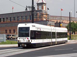
The Newark Light Rail (NLR) is a light rail system serving Newark, New Jersey, and surrounding areas, owned by New Jersey Transit and operated by its bus operations division. The service consists of two segments, the original Newark City Subway (NCS), and the extension to Broad Street station. The City Subway opened on May 16, 1935, while the combined Newark Light Rail service was officially inaugurated on July 17, 2006.

Baltimore Penn Station, formally named Baltimore Pennsylvania Station in full, is the main inter-city passenger rail hub in Baltimore, Maryland. Designed by New York City architect Kenneth MacKenzie Murchison (1872–1938), it was constructed in 1911 in the Beaux-Arts style of architecture for the Pennsylvania Railroad. It is located at 1515 N. Charles Street, about a mile and a half north of downtown and the Inner Harbor, between the Mount Vernon neighborhood to the south, and Station North to the north. Originally called Union Station because it served the Pennsylvania Railroad and Western Maryland Railway, it was renamed to match other Pennsylvania Stations in 1928.

Newark Penn Station is an intermodal passenger station in Newark, New Jersey. One of the New York metropolitan area's major transportation hubs, Newark Penn Station is served by multiple rail and bus carriers, making it the seventh busiest rail station in the United States, and the fourth busiest in the New York City metropolitan area.
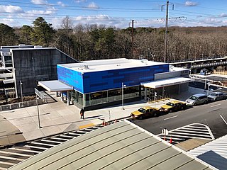
BWI Rail Station is an intermodal passenger station in Linthicum, Maryland near Baltimore/Washington International Airport (BWI). It is served by Amtrak Northeast Corridor intercity trains, MARC Penn Line regional rail trains, and several local bus lines.

The Dartford Loop Line is one of three lines linking London with Dartford in Kent, England. It lies to the south of the other two: the North Kent Line and the Bexleyheath Line.

The West Side Line, also called the West Side Freight Line, is a railroad line on the west side of the New York City borough of Manhattan. North of Penn Station, from 34th Street, the line is used by Amtrak passenger service heading north via Albany to Toronto; Montreal; Niagara Falls and Buffalo, New York; Burlington, Vermont; and Chicago. South of Penn Station, a 1.45-mile (2.33 km) elevated section of the line, abandoned since 1980, has been transformed into an elevated park called the High Line. The south section of the park from Gansevoort Street to 20th Street opened in 2009 and the second section up to 30th Street opened in 2011, while the final section to 34th Street opened in 2014.

The Baltimore and Potomac Railroad (B&P) operated from Baltimore, Maryland, southwest to Washington, D.C., from 1872 to 1902. Owned and operated by the Pennsylvania Railroad, it was the second railroad company to connect the nation's capital to the Northeastern U.S., and competed with the older Baltimore and Ohio Railroad.

The Hudson Line is a commuter rail line owned and operated by the Metro-North Railroad in the U.S. state of New York. It runs north from New York City along the east shore of the Hudson River, terminating at Poughkeepsie. The line was originally the Hudson River Railroad, and eventually became the Hudson Division of the New York Central Railroad. It runs along what was the far southern leg of the Central's famed "Water Level Route" to Chicago.

Broad Street Station at Broad & Market streets was the primary passenger terminal for the Pennsylvania Railroad (PRR) in Philadelphia from early December 1881 to the 1950s. Located directly west of Philadelphia City Hall, the site is now occupied by the northwest section of Dilworth Park and the office towers of Penn Center.

The Northern Central Railway (NCRY) was a Class I Railroad in the United States connecting Baltimore, Maryland, with Sunbury, Pennsylvania, along the Susquehanna River. Completed in 1858, the line came under the control of the Pennsylvania Railroad (PRR) in 1861, when the PRR acquired a controlling interest in the Northern Central's stock to compete with the rival Baltimore and Ohio Railroad (B&O).

The Baltimore Light RailLink is a light rail system serving Baltimore, Maryland, United States, and its northern and southern suburbs. It is operated by the Maryland Transit Administration. In downtown Baltimore, it uses city streets. Outside the central portions of the city, the line is built on private rights-of-way, mostly from the defunct Northern Central Railway, Baltimore and Annapolis Railroad and Washington, Baltimore and Annapolis Electric Railway. The system had a ridership of 3,546,300, or about 12,500 per weekday, as of the fourth quarter of 2023.

Gretna Green is a railway station on the Glasgow South Western Line, which runs between Carlisle and Glasgow Central via Kilmarnock. The station, situated 9 miles 58 chains (16 km) north-west of Carlisle, serves the town of Gretna and village of Gretna Green in Dumfries and Galloway, Scotland. It is owned by Network Rail and managed by ScotRail.

The Sydney Freight Network is a network of dedicated railway lines for freight in Sydney, Australia, linking the state's rural and interstate rail network with the city's main yard at Enfield and Port Botany. Its primary components are the Southern Sydney Freight Line (SSFL) and a line from Sefton to Enfield and Port Botany. The Network has been managed by the Australian Rail Track Corporation (ARTC) since 2012. Prior to the completion of the SSFL, it was managed by RailCorp as the Metropolitan Freight Network.
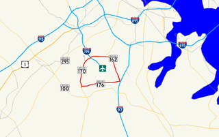
Airport Loop is the designation for the portions of state highways that form a circumferential highway around Baltimore/Washington International Thurgood Marshall Airport in Anne Arundel County in the U.S. state of Maryland. The loop runs 8.44 miles (13.58 km) through the communities of Linthicum, Ferndale, and Hanover. Airport Loop consists of a 3.47-mile (5.58 km) section of Maryland Route 170 (MD 170) along the western and northern sides of the loop; the entire 2.31-mile (3.72 km) length of MD 162 on the eastern side of the loop; and a 2.66-mile (4.28 km) segment of MD 176 on the southern side of the loop. Airport Loop intersects Interstate 195 (I-195), which provides freeway access to the airport terminal, and is connected to I-695, I-97, and MD 100 via connecting highways. The MD 170 and MD 162 sections of Airport Loop are part of the National Highway System.

The Penn Line is a MARC passenger rail service operating between Union Station in Washington, D.C., and Perryville, Maryland, along the far southern leg of the Northeast Corridor; most trains terminate at Baltimore's Penn Station. It is MARC's only electrified line, though a majority of trains remain diesel powered. With trains operating at speeds of up to 125 miles per hour (201 km/h), it is the fastest commuter rail line in the United States. The service is operated by Amtrak under contract to the Maryland Transit Administration. MARC sets the schedules, owns most of the stations, and controls fares, while Amtrak owns and maintains the right-of-way, supplies employees to operate trains, and maintains the rolling stock. It is the busiest of MARC's three lines, with twice as many trains and riders as the Brunswick and Camden lines combined.

Camden Station, now also referred to as Camden Street Station, Camden Yards, and formally as the Transportation Center at Camden Yards, is a train station at the intersection of South Howard and West Camden Streets in Baltimore, Maryland, adjacent to Oriole Park at Camden Yards, behind the B&O Warehouse. It is served by MARC commuter rail service and local Light Rail trains.

Halethorpe station is a passenger rail station located in the unincorporated community of Halethorpe, Maryland on the Northeast Corridor. MARC Penn Line trains serve the station; Amtrak trains pass through but do not stop.

The Washington, Baltimore and Annapolis Electric Railway (WB&A) was an American railroad of central Maryland and Washington, D.C., built in the 19th and 20th century. The WB&A absorbed two older railroads, the Annapolis and Elk Ridge Railroad and the Baltimore & Annapolis Short Line, and added its own electric streetcar line between Baltimore and Washington. It was built by a group of Cleveland, Ohio, electric railway entrepreneurs to serve as a high-speed, showpiece line using the most advanced technology of the time. It served Washington, Baltimore, and Annapolis, Maryland, for 27 years before the "Great Depression" and the rise of the automobile forced an end to passenger service during the economic pressures of the 1930s "Depression" southwest to Washington from Baltimore & west from Annapolis in 1935. Only the Baltimore & Annapolis portion between the state's largest city and its state capital continued to operate electric rail cars for another two decades, replaced by a bus service during the late 1950s into 1968. Today, parts of the right-of-way are used for the light rail line, rail trail for hiking - biking trails, and roads through Anne Arundel County.

The S Line, or S-Line, is a public transit streetcar line in northeastern Salt Lake County, Utah, in the United States, that connects the business district of the Sugar House neighborhood of Salt Lake City with the neighboring city of South Salt Lake, as well as the Utah Transit Authority's (UTA) TRAX light rail system. It is a joint project between UTA, Salt Lake City, and South Salt Lake. It opened for service on December 8, 2013. It is operated by UTA and is UTA's first streetcar line.
The Carlingford railway line was a railway line in Sydney, New South Wales, Australia. It was opened from Clyde to Subiaco in January 1885, then by means of the construction of a bridge across the Parramatta River, to Carlingford in April 1896. It closed on 5 January 2020 with much of the line to be converted to light rail as part of the Parramatta Light Rail network, while a short section of the line was retained for use by Sydney Trains.
