
Cherry Hill is one of the southernmost neighborhoods in Baltimore, Maryland.

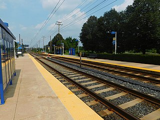
West Baltimore station is a commuter rail station located in the western part Baltimore, Maryland, along the Northeast Corridor. It is served by MARC Penn Line trains. The station is positioned on an elevated grade at 400 Smallwood Street near parallel West Mulberry and West Franklin Streets extending off U.S. Route 40. Three large surface lots are available for commuters. The station only has staircases from street level and two low-level side platforms next to the outer tracks and is thus not accessible to people with some mobility disabilities, but MTA Maryland plans to renovate the station with accessible platforms and entrances.

The Baltimore Light RailLink is a light rail system serving Baltimore, Maryland, United States, and its northern and southern suburbs. It is operated by the Maryland Transit Administration. In downtown Baltimore, it uses city streets. Outside the central portions of the city, the line is built on private rights-of-way, mostly from the defunct Northern Central Railway, Baltimore and Annapolis Railroad and Washington, Baltimore and Annapolis Electric Railway. The system had a ridership of 3,262,100, or about 14,600 per weekday, as of the third quarter of 2023.

Camden Station, now also referred to as Camden Street Station, Camden Yards, and formally as the Transportation Center at Camden Yards, is a train station at the intersection of South Howard and West Camden Streets in Baltimore, Maryland, adjacent to Oriole Park at Camden Yards, behind the B&O Warehouse. It is served by MARC commuter rail service and local Light Rail trains.

North Avenue station is a Baltimore Light Rail station located on North Avenue near the I-83 interchange in Baltimore, Maryland. The station has two island platforms serving three tracks.

Patapsco station is a Baltimore Light Rail station in Halethorpe, Maryland. The stop is located along Patapsco Avenue from which its name is derived. The station serves as a hub for several MTA bus routes. Patapsco was the final stop along the line for a period from September 1992 until April 1993, when the line was extended to Linthicum.

BWI Airport station is a Baltimore Light RailLink station at the Baltimore-Washington International Airport in Maryland. It is one of the two southern terminals of the Baltimore Light Rail. The station platforms are just outside an entrance to the International Concourse on the lower level.
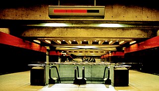
State Center station is an underground Baltimore Metro SubwayLink station in Baltimore, Maryland. It is a transit hub offering connections to the Baltimore Light RailLink system, the tenth most northern and western station on the line, the first one in the area viewed by many as "downtown Baltimore," and is within a 2 block walk of the Cultural Center station on the Light RailLink syste, via Preston Street, and many area landmarks.

Falls Road station is a Baltimore Light Rail station in the southwest corner of Towson, Maryland, located near the Mount Washington neighborhood of Baltimore and the Bare Hills Historic District in the Jones Falls Valley. It has two side platforms serving two tracks, one in each direction. A 0.3 mile boardwalk provides access from the parking lot to neighboring Lake Roland Park.

Baltimore Arena station is a Baltimore Light RailLink station in Baltimore, Maryland adjacent to the CFG Bank Arena.
Baltimore Highlands station is a Baltimore Light Rail stop in Halethorpe, Maryland. There are currently 50 free parking spaces. There are no bus connections at this station.
Convention Center station is a Baltimore Light Rail station in Baltimore, Maryland. It is located adjacent to the Baltimore Convention Center, and is also near the entrance to Oriole Park at Camden Yards. The Convention Center stop was originally called Pratt Street after the cross street by that name.

Stadium/Federal Hill station is a Baltimore Light RailLink station in Baltimore, Maryland, located adjacent to M&T Bank Stadium. Although built to serve the stadium, it also provides access to the nearby Federal Hill and Pigtown neighborhoods.

Route 51 is a bus route operated by the Maryland Transit Administration in Baltimore and its suburbs. The line currently runs from the Rogers Avenue Metro Subway Station to the Patapsco Light Rail Stop, serving the communities of Arlington, Ashburton, Mondawmin, Rosemont, Baltimore, Cherry Hill, and Mt. Winans, and the suburb of Baltimore Highlands.
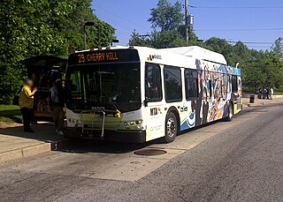
Route 29 was a bus route operated by the Maryland Transit Administration in Baltimore. The line operated on weekdays and Saturdays in a circular fashion, linking the Cherry Hill Light Rail Stop to the Cherry Hill community. Two other MTA bus lines, formerly the routes 27 and 51, also served the Cherry Hill area.

Mt. Royal/MICA station, often referred to interchangeably as University of Baltimore/Mt. Royal station, is a Baltimore Light RailLink station in Baltimore, Maryland. It is on the northwest edge of the University of Baltimore campus and on the northern edge of the MICA campus, across Mount Royal Avenue from the site of Baltimore & Ohio Railroad's former Mount Royal Station. It opened in 1992 as part of the line's initial operating segment. The station's construction was funded by the University of Baltimore for the use of its students after the State of Maryland proposed its elimination from the plan to reduce costs.

Cultural Center station is a Baltimore Light RailLink station located along Howard Street in the Mount Vernon neighborhood of Baltimore, Maryland, adjacent to the Joseph Meyerhoff Symphony Hall. It has two side platforms served by two tracks. The station opened on April 2, 1992, as part of the first phase of the system.

Lexington Market station is a Baltimore Light RailLink station adjacent to Lexington Market in Baltimore, Maryland. The station has two side platforms on the sidewalks of Howard Street. Lexington Market station on the Baltimore Metro SubwayLink is located one block to the west.

Nursery Road station is a Baltimore Light Rail station in Pumphrey, Maryland. There are 37 free parking spaces and connections can be made to MTA Maryland's Route 17 bus from here.

Cold Spring Lane station is a light rail station on the Baltimore Light Rail system. The stop is located on Cold Spring Lane near the interchange with Interstate 83. The station has two side platforms serving two tracks.
