
The Maryland Transit Administration (MTA) is a state-operated mass transit administration in Maryland, and is part of the Maryland Department of Transportation. The MTA operates a comprehensive transit system throughout the Washington-Baltimore metropolitan area. There are 80 bus lines serving the Baltimore Metropolitan Area, along with rail services that include the Light Rail, Metro Subway, and MARC Train. In 2023, the system had a ridership of 52,922,000, or about per weekday as of the fourth quarter of 2023.
BWI Rail Station is an intermodal passenger station in Linthicum, Maryland near Baltimore/Washington International Airport (BWI). It is served by Amtrak Northeast Corridor intercity trains, MARC Penn Line regional rail trains, and several local bus lines.

The Baltimore Metro SubwayLink is a rapid transit line serving Baltimore, Maryland, and its northwestern suburbs, operated by the Maryland Transit Administration. The segment in Downtown Baltimore is underground, while most of the line outside the central city is elevated or at surface grade. In 2023, the line had a ridership of 1,988,300, or about 7,953 per weekday as of the fourth quarter of 2023.

The Baltimore Light RailLink is a light rail system serving Baltimore, Maryland, United States, and its northern and southern suburbs. It is operated by the Maryland Transit Administration. In downtown Baltimore, it uses city streets. Outside the central portions of the city, the line is built on private rights-of-way, mostly from the defunct Northern Central Railway, Baltimore and Annapolis Railroad and Washington, Baltimore and Annapolis Electric Railway. The system had a ridership of 3,546,300, or about 12,500 per weekday, as of the fourth quarter of 2023.
The Red Line is a proposed east–west transit line for Baltimore, Maryland. The original project was granted federal approval to enter the preliminary engineering phase and the Maryland Transit Administration had spent roughly $300 million in planning, design and land acquisition, until Maryland Governor Larry Hogan declared his intent to not provide state funds for the project and shift state funding to roads in suburban areas. The original Red Line had been projected to cost roughly $1.6 billion, $900 million of which would have been guaranteed federal funding. Its construction had been estimated to begin in late 2015–early 2016, subject to funding, with a completion date set for late 2021–early 2022.
The Green Line is a proposed mass transit line for the Baltimore, Maryland area in the United States. It is still in the planning stages and its construction is not guaranteed.
Lutherville is a census-designated place (CDP) in Baltimore County, Maryland, United States. As of the 2010 census it had a population of 6,504. Prior to 2010 the area was part of the Lutherville-Timonium CDP. Within its borders lies the Lutherville Historic District.

LocalLink 93 is a bus route operated by the Maryland Transit Administration in the suburbs of Baltimore. The line currently runs from the Lutherville Light Rail Stop to International Circle near Hunt Valley Town Center, serving the Timonium and Cockeysville areas.

LocalLink 75 is a bus route operated by the Maryland Transit Administration in Baltimore and its suburbs. The line currently runs from the Patapsco Light Rail Stop to Arundel Mills in Anne Arundel County, via BWI Airport. The line operates to University of Maryland during hours when the light rail is not operating.

CityLink Red is a MTA BaltimoreLink bus route operated by the Maryland Transit Administration in Baltimore and its suburbs. The line currently runs from the University of Maryland Transit Center to the Lutherville Light Rail Stop along the corridors of York Road and Greenmount Avenue, and is the most heavily used MTA bus line. The CityLink Red bus replaced Route 8 bus route due to BaltimoreLink, and is the successor to the 8 Towson and 7 Govanstown streetcar lines.
Route 51 is a bus route operated by the Maryland Transit Administration in Baltimore and its suburbs. The line currently runs from the center of Towson to the Inner Harbor in Downtown Baltimore, serving the Charles Street corridor. Route 51 replaced Route 11 on June 18, 2017 due to the BaltimoreLink bus system overhaul.

CityLink Gold is a bus route operated by the Maryland Transit Administration in Baltimore. It replaced Route 13 in 2017. The line currently runs from Walbrook Junction in West Baltimore to Canton, mostly along North Avenue. The line has two main branches, both operating to Canton: one that operates via Fells Point and the other via Linwood and East Streets. Both these branches serve Johns Hopkins Hospital. Additionally, selected trips on weekdays and Saturdays operate to the block of Milton Avenue, Federal Street, and Patterson Park Avenue.

The Maryland Transit Administration was originally known as the Baltimore Metropolitan Transit Authority, then the Maryland Mass Transit Administration before it changed to its current name in October 2001. The MTA took over the operations of the old Baltimore Transit Company on April 30, 1970.

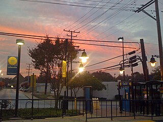
Lutherville station is a Baltimore Light Rail station located in Lutherville, Maryland. Like most suburban stations on the system, it has two side platforms serving the line's two tracks. It opened in 1992 as part of the initial operating segment.
Route 52 is a bus route operated by the Maryland Transit Administration in Baltimore and its suburbs. The line is a dedicated service for employees of Stella Maris, a complex of long term care facilities in Timonium, Maryland. Route 52 replaced Route 12 under BaltimoreLink.

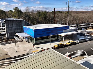
Charles Center station is an underground 2 floor Metro SubwayLink station in Baltimore, Maryland making it the largest station on the line. Located at the Charles Center in Downtown Baltimore, it is a downtown transportation hub serving many bus lines, nearby various landmarks, and bus transfers. It was the final stop of the line until 1995, when the extension to Johns Hopkins Hospital opened. The station is in close proximity to CFG Bank Arena as well as the Baltimore Arena station on the Light RailLink. The station has two street level entrances via escalators and elevators and is the center most station on the line serving Central Downtown Baltimore.
The Charles Street Trolley is a proposed streetcar line running through northern portions of Baltimore, Maryland, United States. Kittelson & Associates, Inc., a consulting firm hired by trolley advocates, estimates that the line would be likely to carry 2.5 million riders per year.

Regional Transportation Agency of Central Maryland, locally referred to as the RTA, is a transit organization providing fixed-route and paratransit services across Central Maryland. The RTA is made up of multiple jurisdictions including Anne Arundel County, Howard County, the City of Laurel, Northern Prince George's County, and Baltimore County.
UMBC Transit is the official bus system of the University of Maryland, Baltimore County. Along with the Maryland Transit Administration (MTA), the UMBC community has public transit access to nearby areas such as Catonsville, Arbutus, Maryland, and Baltimore City.
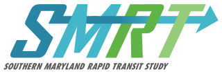
Southern Maryland Rapid Transit, abbreviated as SMRT, is a proposed mass transit line along the Maryland Route 5 and U.S. Route 301 highway corridors in between Washington, D.C., and Waldorf, Maryland. The project would link the heavily populated suburbs of northwestern Southern Maryland with Washington via a direct transit connection to the Washington Metro at Branch Avenue station.