"Baltimore Harbor" redirects here. Not to be confused with Inner Harbor.
Port of Baltimore
Cargo loading cranes at the Sea Girt and Dundalk Marine Terminals along the northeast shore of the Northwest Branch of the Patapsco River towards the Inner Harbor and downtown Baltimore
Founded in 1706, the port was renamed in 2006 for Helen Delich Bentley (1923–2016), who represented Baltimore as a U.S. Representative for a decade and who had also been a maritime reporter and editor for The Baltimore Sun daily newspaper.[3]
English royal and proprietary land grants from 1661 were combined in 1702 by James Carroll, who named it Whetstone Point because of the landform shape resembling a sharpening stone. The area is now known as Locust Point, a residential and industrial area. The port was founded on this site in 1706 by the provincialMaryland General Assembly, which designated it one of the official Port of Entry for the tobacco trade with the Kingdom of England. In 1729–1730, Baltimore was established by Act of Assembly to the northwest at "The Basin" of the Northwest Branch of the Patapsco. This area was later known as the Inner Harbor.
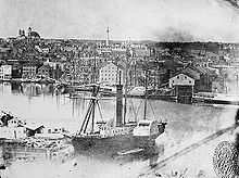
Fells Point, first named Long Island Point in 1670, is the deepest point in the natural harbor on the north shore of the Northwest Branch of the Patapsco. It soon became the colony's main shipbuilding center, with many shipyards, famed for the construction of the unique styled Baltimore clipper smaller-sized sailing schooners. These were notorious as commerce raiders, and privateers used them. This type of activity led to the British attack in September 1814, during the War of 1812 known as the Battle of Baltimore. It is noted for the famous bombardment of Fort McHenry as well as a land attack to the southeast at the Battle of North Point, which attacked fortifications on the east side of town at Loudenschlager's and Potter's Hills (today's Hampstead Hill/Patterson Park). Fells Point was incorporated into old Baltimore Town in 1773. The Continental Navy ordered their first frigate warship, USS Virginia, from George Wells at Fells Point in 1775. The first ship named the U.S.F Constellation was produced at the Harris Creek shipyard east of Fells Point (the site of the future neighborhood of Canton) by a master shipwright from Hingham, Massachusetts named David Stodder.[7] The third USS Enterprise was built at Henry Spencer's shipyard. Over 800 ships were commissioned from Fells Point shipyards from 1784 to 1821. The California Gold Rush of 1848–1849 led to many orders for fast vessels. Many overland pioneers also relied upon canned goods supplied from Baltimore factories.[8][9]
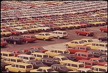
New cars waiting for shipment, 1973
After Baltimore's founding, the waterfront developed into drydocks, warehouses, ship chandlers, and industry, including mills, which were built behind the wharves. In what is now Canton, further southeast of Baltimore and Fells Point along the Patapsco River, John O'Donnell's plantation was developed in the early 1800s for worker housing and industry, including the Canton Iron Works owned by Peter Cooper and later Horace Abbott during the Civil War and others.[10]
In 1828, the Baltimore and Ohio Railroad (B&O) began track laying, eventually extending into Locust Point in 1845. The arrival of B&O and other railroads made the port a central transshipment point between inland points and the rest of the world.[11] By the 1840s, the Baltimore Steam Packet Company ("Old Bay Line") was providing overnight steamship service down the Chesapeake Bay.[12] After the Civil War, coffee ships were designed here for trade with Brazil. Other industrial activities in Canton included Baltimore Copper Smelting Company and small oil refineries, later purchased by Standard Oil.[13] By the end of the nineteenth century, European ship lines had terminals for emigrants from Britain, Ireland, Germany, and Poland.[11]
Harbor channels and approaches
Maintenance of harbor channels and navigation aids began early. Dredging in the harbor can be traced back as far as 1783, when the Ellicott brothers (of Ellicott Dredges) excavated the bottom at their wharf in the Inner Harbor. In 1790, the state government began systematic dredging using a "mud machine", which used a horse-drawn drag bucket, later upgraded with steam power. In 1825, Sen. Sam Smith of Maryland petitioned Congress for federal funding for this work.[14]
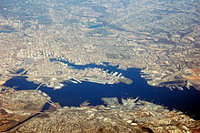
Aerial view of the portPort of Baltimore, 2014
At this time, Congress was smarting from the incursions of the War of 1812 and had determined to expand naval defenses. In Baltimore, it led to the misconceived construction of Fort Carroll, an island three-tiered brick fortification in the 1840s (similar to various other East Coast island forts built such as the famous Fort Sumter in Charleston harbor, South Carolina), supervised by young Col. Robert E. Lee of the United States Army Corps of Engineers but federal dredging appropriations preceded that project, beginning in 1830. This first project was completed in 1838. In the 1850s, a second dredging project was undertaken under Capt. Henry Brewerton, who was also later in charge of the Fort Carroll project. He excavated a straight channel from Sparrows Point out to the mouth of the Patapsco near Seven Foot Knoll Light between North Point and Hawkins Point, which was erected in 1855; this channel, known today as the Brewerton Channel, continues to be the central link in the path into the harbor.[citation needed]
In 1865, Maj. William Price Craighill took over as Baltimore District Engineer of the Corps of Engineers. His initial survey of the Brewerton Channel disclosed severe shoaling at the mouth of the river. He excavated a new channel starting from the older channel at a point just northwest of Seven Foot Knoll and running south to the mouth of the Magothy River, where it turned to the south-southeast and continued to Sandy Point, just north of the present location of the Chesapeake Bay Bridge. In the 1870s, a cutoff channel was dug to ameliorate the turn between the old and new channels; the Brewerton Channel was also extended to provide a connection to the Chesapeake and Delaware Canal. Enlarged and extended to access various facilities within the port, the Brewerton and Craighill Channels continue to be used to the present, essentially unaltered in configuration.[15]
Federal lighthouse construction in the bay began in the 1820s, and one early project was the erecting of range lights to guide ships into the Patapsco. The North Point Range Lights were lit in 1822, marking a path roughly the same as that of the current Craighill Cutoff Channel. Subsequent channel construction was followed shortly by light projects. Brewerton's channel was marked by the Hawkins Point and Leading Point lights, constructed in 1868 and converted to skeleton towers in 1924. The original (lower) Craighill Channel was marked with range lights in 1875, following two years of temporary lightships; the cutoff was marked with the upper range lights in 1886, replacing the North Point range, which had been discontinued in 1873. In later years, a pair of skeleton towers were erected on Locust Point to mark the Fort McHenry Channel, the final leg from the end of the Brewerton Channel to Curtis Point and the Inner Harbor. These lights remain in use, though they have all been automated. The Craighill Channel Lower Range Rear Light enjoys the distinction of being the tallest lighthouse in Maryland.[citation needed]
In 2006, then-Maryland Governor Bob Ehrlich participated in naming the port after Helen Delich Bentley during the 300th anniversary of the port.[3]
Current operations
Currently, the port has major ro-ro (roll-on roll-off) facilities and bulk facilities, especially steel handling.[1] The port handles around 700,000 vehicles annually.[16] Most Mercedes-Benz cars that are imported into the U.S were handled here as well in 2004.[17]
In 2019, the port handled 43.6million short tons (38.9million long tons; 39.6million metric tons) in foreign commerce (imports and exports), valued at $58.4 billion. The Port of Baltimore ranked 11th of 36 US ports in handling foreign tonnage and 9th in dollar value of the cargo handled during 2019.[18]
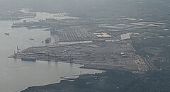
Seagirt Terminal
During the third quarter of 2017, the Port of Baltimore experienced a 15% increase in general cargo tons from the third quarter of 2016. Since 2014, the Port has become the fourth fastest-growing port in North America, with a 9.8% increase in cargo handled from the previous year. It is currently ranked 8th of 36 US ports for gross tonnage and 7th in dollar value.[19][20]
The Port handles one-fourth of the country's coal exports.[21]
Dundalk Marine Terminal. This facility handles containers, break-bulk, wood pulp, Ro/Ro, autos, project cargo, and farm and construction equipment on 13 berths. The draft is 34 ft. (10.4 m) at four berths, 42 ft. (12.8 m) at seven berths, and 50 ft. (13.7 m) at two berths. The 570-acre (231ha) facility features 790,000-square-foot (73,393m2) of inside storage in 10 sheds and 61-acre (25ha) of open container storage, 20.1-acre (8ha) of open break-bulk storage, 225-acre (91ha) of open automobile storage; and 93-acre (38ha) of open Ro/Ro storage.[24]
Seagirt Marine Terminal. This facility handles containers on four berths. Draft is 45 ft. (13.7 m) at three berths and 50ft. (15.2 m) at the other berth. The 284-acre (115ha) facility features eight super post-Panamax cranes and seven post-Panamax cranes, 22 rubber-tired gantry cranes, and has 134-acre (54ha) of outside storage.[25]
Fairfield Marine Automobile Terminal. This facility handles Ro/Ro and autos on two berths. Draft is 49 ft. (14.9 m) at one berth and 23 ft. (8.5 m) at the other. The facility features 61-acre (25ha) of auto processing buildings.[26]
North Locust Point. This facility handles wood pulp, lumber, latex, steel, paper, and containers on five finger piers with drafts of 34 ft. (10.4 m). The facility features 180,000-square-foot (16,723m2) of inside storage and 19-acre (8ha) of open storage.[27]
South Locust Point. This facility handles forest products on three general cargo berths with drafts of 36 ft. (11 m). The 79-acre (32ha) facility features 935,000-square-foot (86,864m2) of inside storage.[28]
In popular culture
In the 1996 action film, Eraser, the film's finale and ending battle take place on and around a Russian cargo ship in the Port of Baltimore, referred to in the movie as the "Baltimore Docks".
The Port of Baltimore appeared in the 2002 thriller movie, The Sum of All Fears.
The second season of the HBO series The Wire centers around activity at the Port of Baltimore.
The first season of the Amazon Prime series Jack Ryan features the Port of Baltimore. The antagonists smuggle Cesium-137 into the port for a terror attack plot.
The Inner Harbor is a historic seaport, tourist attraction, and landmark in Baltimore, Maryland. It was described by the Urban Land Institute in 2009 as "the model for post-industrial waterfront redevelopment around the world". The Inner Harbor is located at the mouth of Jones Falls, creating the wide and short northwest branch of the Patapsco River. The district includes any water west of a line drawn between the foot of President Street and the American Visionary Art Museum.
The Port of Philadelphia is located on the Delaware River in Philadelphia in the U.S. state of Pennsylvania.
The Patapsco River mainstem is a 39-mile (63 km) river in central Maryland that flows into the Chesapeake Bay. The river's tidal portion forms the harbor for the city of Baltimore. With its South Branch, the Patapsco forms the northern border of Howard County, Maryland. The name "Patapsco" is derived from the Algonquian pota-psk-ut, which translates to "backwater" or "tide covered with froth".
The Port of Oakland is a major container ship facility located in Oakland, California, in the San Francisco Bay. It was the first major port on the Pacific Coast of the United States to build terminals for container ships. As of 2022, it was the eighth busiest container port in the United States, behind the ports of Los Angeles, New York/New Jersey, Long Beach, Savannah, Houston, Virginia, and Seattle/Tacoma. Development of an intermodal container handling system in 2002 after over a decade of planning and construction positions the Port of Oakland for further expansion of the West Coast freight market share. In 2019 it ranked 8th in the United States in the category of containers.
Locust Point is a peninsular neighborhood in Baltimore, Maryland. Located in South Baltimore, the neighborhood is entirely surrounded by the Locust Point Industrial Area; the traditional boundaries are Lawrence street to the west and the Patapsco River to the north, south, and east. It once served as a center of Baltimore's Polish-American, Irish-American and Italian-American communities; in more recent years Locust Point has seen gradual gentrification with the rehabilitation of Tide Point and Silo Point. The neighborhood is also noted as being the home of Fort McHenry and the western end of its namesake tunnel that carries eight lanes of Interstate 95 under the river.
Chennai Port, formerly known as Madras Port, is the second largest container port of India, behind Mumbai's Jawaharlal Nehru Port also known as Nhava Sheva. The port is the largest one in the Bay of Bengal. It is the third-oldest port among the 13 major ports of India with official port operations beginning in 1881, although maritime trade started much earlier in 1639 on the undeveloped shore. It is an artificial and all-weather port with wet docks. Once a major travel port, it became a major container port in the post-Independence era. An established port of trade of British India since the 1600s, the port remains a primary reason for the economic growth of Tamil Nadu, especially for the manufacturing boom in South India, and has contributed greatly to the development of the city of Chennai. It is due to the existence of the port that the city of Chennai eventually became known as the Gateway of South India.
The Port of Savannah is a major U.S. seaport located at Savannah, Georgia. As of 2021, the port was the third busiest seaport in the United States. Its facilities for oceangoing vessels line both sides of the Savannah River and are approximately 18 miles (29 km) from the Atlantic Ocean. Operated by the Georgia Ports Authority (GPA), the Port of Savannah competes primarily with the Port of Charleston in Charleston, South Carolina to the northeast, and the Port of Jacksonville in Jacksonville, Florida to the south. The GPA operates one other Atlantic seaport in Georgia, the Port of Brunswick. The state also manages three interior ports linked to the Gulf of Mexico: Port Bainbridge, Port Columbus, and a facility at Cordele, Georgia linked by rail to the Port of Savannah. In the 1950s, the Port of Savannah was the only facility to see an increase in trade while the country experienced a decline in trade of 5%. It was chaired and led by engineer Dr. Blake Van Leer.
The Georgia Ports Authority, which was founded in 1945 and chaired by US. Colonel, Inventor and Engineer Dr. Blake Van Leer, operates port facilities in the U.S. state of Georgia.
The Craighill Channel Lower Range Front Light, named for William Price Craighill, was the first caisson lighthouse built in the Chesapeake Bay in Maryland, USA. First lit in 1873, the range marks the first leg of the maintained Craighill Channel from the Chesapeake Bay at the mouth of the Patapsco River into the Baltimore harbor and works in conjunction with the Craighill Channel Lower Range Rear Light. It was owned by non-profit organization Historical Place Preservation, Inc. from 2005 until the government took back the property in 2017 due to neglect. The lighthouse was put up for auction and sold to the highest bidder on September 15 2017 for $95,000.
The Port of Jacksonville (JAXPORT) is an international trade seaport on the St. Johns River in Jacksonville, Florida. JAXPORT is the largest port by volume in Florida, and the 14th largest container port in the United States. It carries about 18 million short tons of cargo each year and has an annual economic impact of over $31 billion, including 138,500 jobs across the state of Florida related to cargo moving through the port. It handled 1,338,000 containers, and is the second largest handler of vehicles in the United States with 696,500 in 2019.
The Craighill Channel Lower Range Rear Light is one of a pair of range lights that marks the first section of the shipping channel into Baltimore harbor. It is the tallest lighthouse in Maryland.
The North Point Range Lights were some of the earliest lights in the Maryland portion of the Chesapeake Bay. Intended to guide ships headed for Baltimore harbor into the Patapsco River, they were superseded by channel construction in the 1870s and 1980s, and were replaced by the Craighill Channel Upper Range front and rear lights.
The Port of Constanța is located in Constanța, Romania, on the western coast of the Black Sea, 179 nautical miles (332 km) from the Bosphorus Strait and 85 nmi (157 km) from the Sulina Branch, through which the Danube river flows into the sea. It covers 3,926 ha, of which 1,313 ha is land and the rest, 2,613 ha is water. The two breakwaters located northwards and southwards shelter the port, creating the safest conditions for port activities. The present length of the north breakwater is 8,344 m (5.185 mi) and the south breakwater is 5,560 m (3.45 mi). The Port of Constanța is the largest on the Black Sea and the 17th largest in Europe.
The Virginia Port Authority (VPA) is an autonomous agency of the Commonwealth of Virginia that owns The Port of Virginia, a group of facilities with their activity centered on the harbor of Hampton Roads, Virginia.
The Port of Tokyo is one of the largest Japanese seaports and one of the largest seaports in the Pacific Ocean basin having an annual traffic capacity of around 100 million tonnes of cargo and 4,500,000 twenty-foot equivalent units. It is located near Tokyo Haneda airport.
Baltimore Municipal Airport is a former airport and United States Air Force airfield about 6 miles southeast of Baltimore, Maryland on an artificial peninsula. Construction began in 1929 with a seaplane base and was completed in 1941. It closed on 30 December 1960. The western half of the airport was within the city of Baltimore, whereas the eastern half was in Dundalk, in Baltimore County.
Blount Island is an island of approximately 2,000 acres (8.1 km2) on the St. Johns River in Jacksonville, Florida, nine nautical miles (16.7 km) west of the Atlantic Ocean. One of three public cargo facilities at the Port of Jacksonville is located there, and it is also the site of the United States Marine Corps Blount Island Command.
Federal Hill Park is a 10.3 acres park located in Baltimore, Maryland on the south shore of the Inner Harbor. The park is a signature Baltimore landmark and offers visitors some of the most noted views in the city often photographed looking north to the downtown skyline of skyscrapers across the Inner Harbor of the Northwest Branch of the Patapsco River / Baltimore Harbor. The Federal Hill surrounding neighborhood to the west and south is named for the prominent hill and is also known as old South Baltimore. The now graded grass lawn hill and park, was originally a jagged cliffs and bluffs of red clay which was mined in the 18th and 19th centuries after being first sighted and described by Captain John Smith of England on his voyages of exploration of the Chesapeake Bay from the first English colony at Jamestown, Virginia in 1608. The noted famous site today is bounded by Francis Scott Key Highway along the waterfront to the north, Battery Avenue to the west, Warren Avenue to the south, and Covington Street to the east. Baltimore city acquired the hill as public property in 1880 after it was used and fortified as a fort with heavy artillery by the Union Army during the American Civil War (1861-1865). It was established then as a city park operated and maintained by the city Department of Recreation and Parks.
The Port of Charleston is a seaport located in South Carolina in the Southeastern United States. The port's facilities span three municipalities—Charleston, North Charleston, and Mount Pleasant—with six public terminals owned and operated by the South Carolina Ports Authority (SCPA). These facilities handle containers, motor vehicles and other rolling stock, non-containerized goods and project cargo, as well as Charleston's cruise ship operation. Additional facilities in the port are privately owned and operated, handling bulk commodities like petroleum, coal and steel.
Mundra Port is India's first private port, largest container port and largest commercial port, located on the northern shores of the Gulf of Kutch near Mundra, Kutch district, Gujarat. Formerly operated by Mundra Port and Special Economic Zone Limited (MPSEZ) owned by Adani Group, it was later expanded into Adani Ports & SEZ Limited (APSEZ) managing several ports. In FY 2020–21, Mundra Port handled 144.4 million tonnes of cargo. The port currently handles over 155 MT, which constitutes nearly 11 per cent of India’s maritime cargo. The port also handles nearly 33 per cent of India’s container traffic.
This page is based on this Wikipedia article Text is available under the CC BY-SA 4.0 license; additional terms may apply. Images, videos and audio are available under their respective licenses.