
The Seven Foot Knoll Light was built in 1855 and is the oldest screw-pile lighthouse in Maryland. It was located atop Seven Foot Knoll in the Chesapeake Bay until it was replaced by a modern navigational aid and relocated to Baltimore's Inner Harbor as a museum exhibit.

The Thomas Point Shoal Light, also known as Thomas Point Shoal Light Station, is a historic lighthouse in the Chesapeake Bay on the east coast of the United States, and the most recognized lighthouse in Maryland. It is the only screw-pile lighthouse in the bay which stands at its original site. The current structure is a 1½ story hexagonal wooden cottage, equipped with a foghorn as well as the light.

The Baltimore Harbor Light, officially Baltimore Light and historically Baltimore Harbor Lighthouse is a privately owned caisson lighthouse in the Chesapeake Bay in Maryland. First lit in 1908, it sits at the mouth of the Magothy River, marking the channel which leads northwest to the opening of the Patapsco River, which then leads into the Baltimore harbor. At the time of its construction, it was the world's tallest caisson lighthouse. In June 2006, Baltimore Light was sold at auction to private owners by the General Services Administration for $260,000; the U.S. Coast Guard maintains rights to operate a light on the structure.

Point No Point Light, located in the Chesapeake Bay off the eponymous point several miles north of the mouth of the Potomac River, was constructed as part of a program to add lighted navigational aids in a thirty-mile stretch of the bay between Cove and Smith Points.

Concord Point Light is a 36-foot (11 m) lighthouse in Havre de Grace, Maryland, United States, overlooking the point where the Susquehanna River flows into the Chesapeake Bay, an area of increasing navigational traffic when it was constructed in 1827. It is the northernmost lighthouse and the second-oldest tower lighthouse still standing on the bay.

The Craighill Channel Lower Range Front Light, named for William Price Craighill, was the first caisson lighthouse built in the Chesapeake Bay in Maryland, USA. First lit in 1873, the range marks the first leg of the maintained Craighill Channel from the Chesapeake Bay at the mouth of the Patapsco River into the Baltimore harbor and works in conjunction with the Craighill Channel Lower Range Rear Light. It has been owned by non-profit organization Historical Place Preservation, Inc. since 2005.

The Sharps Island Light is the third lighthouse to stand nearly 3 miles (5 km) south-southwest from the southern end of Tilghman Island in Maryland's Chesapeake Bay. The structure is best known today for evoking the Leaning Tower of Pisa, a condition caused by an ice floe in 1977.

Sandy Point Shoal Light is a brick three story lighthouse on a caisson foundation that was erected in 1883. It lies about 0.6 mi (0.97 km) off Sandy Point, north of the Chesapeake Bay Bridge, from whose westbound span it is readily visible.

Helen Delich Bentley Port of Baltimore is a shipping port along the tidal basins of the three branches of the Patapsco River in Baltimore, Maryland on the upper northwest shore of the Chesapeake Bay. It is the nation's largest port facilities for specialized cargo and passenger facilities. It is operated by the Maryland Port Administration (MPA), a unit of the Maryland Department of Transportation.

The Turkey Point Light is a historic lighthouse at the head of the Chesapeake Bay. Although only a 35-foot (11 m) tower, the 100-foot (30 m) height of the bluffs on which it stands makes it the third highest light off the water in the bay. It is also known for the large number of women who served as lightkeeper.

Pooles Island Light is the oldest lighthouse still standing in Maryland and the fourth oldest in the Chesapeake Bay area. The light is located on Pooles Island in the central Chesapeake Bay.

The Cove Point Light is a lighthouse located on the west side of Chesapeake Bay in Calvert County, Maryland.

The Hooper Island Light is a lighthouse in the Chesapeake Bay, west of Middle Hooper Island in Maryland.

Drum Point Light is one of four surviving Chesapeake Bay screw-pile lighthouses. Originally located off Drum Point at the mouth of the Patuxent River, it is now an exhibit at the Calvert Marine Museum.
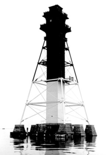
The Craighill Channel Lower Range Rear Light is one of a pair of range lights that marks the first section of the shipping channel into Baltimore harbor. It is the tallest lighthouse in Maryland.
The Hawkins Point Light was an unusual screw-pile lighthouse which displayed the front light to the Brewerton Channel Range. It was eventually superseded by an iron tower on the same foundation.

The Craighill Channel Upper Range Rear Light is one of a pair of range lights that marks the second section of the shipping channel into Baltimore harbor.
The North Point Range Lights were some of the earliest lights in the Maryland portion of the Chesapeake Bay. Intended to guide ships headed for Baltimore harbor into the Patapsco River, they were superseded by channel construction in the 1870s and 1980s, and were replaced by the Craighill Channel Upper Range front and rear lights.


