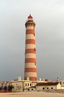
A lighthouse is a tower, building, or other type of structure designed to emit light from a system of lamps and lenses and to serve as a beacon for navigational aid, for maritime pilots at sea or on inland waterways.
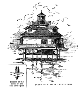
A screw-pile lighthouse is a lighthouse which stands on piles that are screwed into sandy or muddy sea or river bottoms. The first screw-pile lighthouse to begin construction was built by the blind Irish engineer Alexander Mitchell. Construction began in 1838 at the mouth of the Thames and was known as the Maplin Sands lighthouse, and first lit in 1841. However, though its construction began later, the Wyre Light in Fleetwood, Lancashire, was the first to be lit.

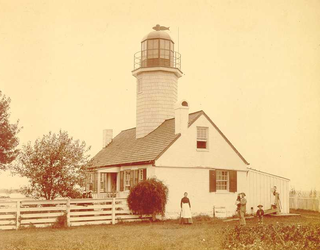
The Seven Foot Knoll Light was built in 1855 and is the oldest screw-pile lighthouse in Maryland. It was located atop Seven Foot Knoll in the Chesapeake Bay until it was replaced by a modern navigational aid and relocated to Baltimore's Inner Harbor as a museum exhibit.

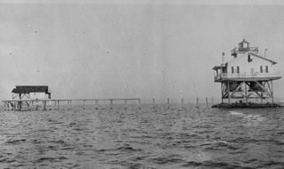
The Thomas Point Shoal Light, also known as Thomas Point Shoal Light Station, is a historic lighthouse in the Chesapeake Bay on the east coast of the United States, and the most recognized lighthouse in Maryland. It is the only screw-pile lighthouse in the bay which stands at its original site. The current structure is a 1½ story hexagonal wooden cottage, equipped with a foghorn as well as the light.

Sand Key Light is a lighthouse 6 nautical miles southwest of Key West, Florida, between Sand Key Channel and Rock Key Channel, two of the channels into Key West, on a reef intermittently covered by sand. At times the key has been substantial enough to have trees, and in 1900 nine to twelve thousand terns nested on the island. At other times the island has been washed away completely.

The Holland Island Bar Light was a screw-pile lighthouse in the Chesapeake Bay which existed from 1889 to 1960. It is remembered for the unexplained death of one of its keepers, and for being "attacked" by United States Navy pilots during a training exercise.
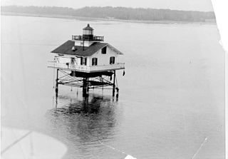
The Upper Cedar Point Light was a screw-pile lighthouse in the Potomac River in Maryland. It was first lit in 1867 and served, except for a brief period of inactivity, until being dismantled in 1963.

Helen Delich Bentley Port of Baltimore is a shipping port along the tidal basins of the three branches of the Patapsco River in Baltimore, Maryland on the upper northwest shore of the Chesapeake Bay. It is the nation's largest port facilities for specialized cargo and passenger facilities. It is operated by the Maryland Port Administration (MPA), a unit of the Maryland Department of Transportation.

Solomons Lump Light is a lighthouse in the Chesapeake Bay, the abbreviated remains of a caisson light built in 1895. That structure replaced a screw-pile light built on the same spot in 1875, which in turn superseded the Fog Point Light.

The Choptank River Light was a screw-pile lighthouse located near Oxford, Maryland. In its second incarnation it was the only such light moved from another location in the Chesapeake Bay.
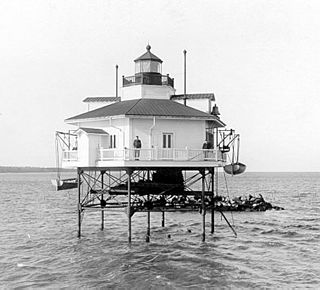
The Ragged Point Light was a screw-pile lighthouse located in the Potomac River. It was the last lighthouse built in Maryland waters and the last built at a location in the Chesapeake Bay.
Greenbury Point Light was the name of two lighthouses in the Chesapeake Bay, both located at the mouth of the Severn River in Annapolis, Maryland.
The Lower Cedar Point Light was a historic lighthouse in the Potomac River near its eponymous point, south of the present U.S. Route 301 bridge. It has been replaced by a skeleton tower.

Love Point Light was a screw-pile lighthouse in the Chesapeake Bay, off the northern end of Kent Island, Maryland.

Hooper Strait Light is one of four surviving Chesapeake Bay screw-pile lighthouses in the U.S. state of Maryland. Originally located in Hooper Strait, between Hooper and Bloodsworth Islands in Dorchester County and at the entrance to Tangier Sound, it is now an exhibit at the Chesapeake Bay Maritime Museum in St. Michaels, Maryland.
The Janes Island Light was a screw-pile lighthouse located near Crisfield in the U.S. state of Maryland. Twice destroyed by ice, it was replaced in 1935 with an automated beacon.
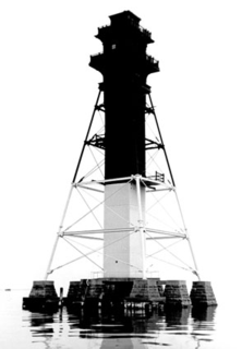
The Craighill Channel Lower Range Rear Light is one of a pair of range lights that marks the first section of the shipping channel into Baltimore harbor. It is the tallest lighthouse in Maryland.
The Leading Point Light was an unusual lighthouse which displayed the rear light to the Brewerton Channel Range. It was eventually superseded by an iron tower on the same foundation.
The North Point Range Lights were some of the earliest lights in the Maryland portion of the Chesapeake Bay. Intended to guide ships headed for Baltimore harbor into the Patapsco River, they were superseded by channel construction in the 1870s and 1980s, and were replaced by the Craighill Channel Upper Range front and rear lights.
The Cat Island Light was a lighthouse located on Cat Island off the coast of Mississippi. Originally built to guide shipping through the Mississippi Sound, it was discontinued as traffic moved further south.

