A screw-pile lighthouse is a lighthouse which stands on piles that are screwed into sandy or muddy sea or river bottoms. The first screw-pile lighthouse to begin construction was built by the blind Irish engineer Alexander Mitchell. Construction began in 1838 at the mouth of the Thames and was known as the Maplin Sands lighthouse, and first lit in 1841. However, though its construction began later, the Wyre Light in Fleetwood, Lancashire, was the first to be lit.

The Seven Foot Knoll Light was built in 1855 and is the oldest screw-pile lighthouse in Maryland. It was located atop Seven Foot Knoll in the Chesapeake Bay until it was replaced by a modern navigational aid and relocated to Baltimore's Inner Harbor as a museum exhibit.

The Baltimore Harbor Light, officially Baltimore Light and historically Baltimore Harbor Lighthouse is a privately owned caisson lighthouse in the Chesapeake Bay in Maryland. First lit in 1908, it sits at the mouth of the Magothy River, marking the channel which leads northwest to the opening of the Patapsco River, which then leads into the Baltimore harbor. At the time of its construction, it was the world's tallest caisson lighthouse. In June 2006, Baltimore Light was sold at auction to private owners by the General Services Administration for $260,000; the U.S. Coast Guard maintains rights to operate a light on the structure.

The Bodkin Island Light was a lighthouse on the Chesapeake Bay, United States, the first erected in Maryland.

Reedy Island Range Rear Lighthouse is a skeletal tower lighthouse near Taylor's Bridge, Delaware. The tower is an active aid to navigation.

The Craighill Channel Lower Range Front Light, named for William Price Craighill, was the first caisson lighthouse built in the Chesapeake Bay in Maryland, USA. First lit in 1873, the range marks the first leg of the maintained Craighill Channel from the Chesapeake Bay at the mouth of the Patapsco River into the Baltimore harbor and works in conjunction with the Craighill Channel Lower Range Rear Light. It has been owned by non-profit organization Historical Place Preservation, Inc. since 2005.

St. Clair Flats Front and Rear Range Light are two lighthouse structures situated off the southeastern tip of Harsens Island at Lake St. Clair.

Helen Delich Bentley Port of Baltimore is a shipping port along the tidal basins of the three branches of the Patapsco River in Baltimore, Maryland on the upper northwest shore of the Chesapeake Bay. It is the nation's largest port facilities for specialized cargo and passenger facilities. It is operated by the Maryland Port Administration (MPA), a unit of the Maryland Department of Transportation.
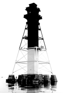
The Craighill Channel Lower Range Rear Light is one of a pair of range lights that marks the first section of the shipping channel into Baltimore harbor. It is the tallest lighthouse in Maryland.
Fort Carroll Light is a derelict lighthouse consisting of a short wooden tower on the walls of its namesake fortifications in the Patapsco River.
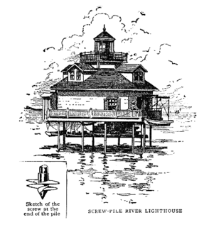
The Hawkins Point Light was an unusual screw-pile lighthouse which displayed the front light to the Brewerton Channel Range. It was eventually superseded by an iron tower on the same foundation.

The Craighill Channel Upper Range Rear Light is one of a pair of range lights that marks the second section of the shipping channel into Baltimore harbor.
The Leading Point Light was an unusual lighthouse which displayed the rear light to the Brewerton Channel Range. It was eventually superseded by an iron tower on the same foundation.

The Craighill Channel Upper Range Front Light is one of a pair of range lights that marks the second section of the shipping channel into Baltimore harbor.
The Grassy Island Range Lights were a pair of lighthouses which were originally established to guide traffic through the channel into Green Bay harbor. They were deactivated and moved to shore as part of a channel-widening project.
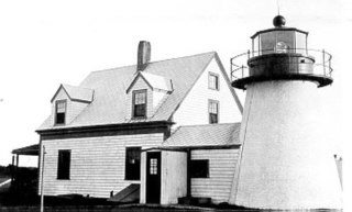
The Hyannis Rear Range Light, also known as the Hyannis Harbor Light, was a lighthouse and, for part of its life, one of a pair of range lights adjacent to Hyannis Harbor. The Range Rear tower was built in 1849 and equipped with a 5th order Fresnel lens in 1856. In 1863 the original birdcage lantern was replaced with a new cast iron one. In 1885, a front range light was added on the Old Colony Railroad Wharf, and the two lights together served to leading vessels to the wharf. The 20 foot Range Rear tower is shorter than most lighthouses, as its purpose was just to guide ships to the wharf. In the early 1800s, the railroad extended from its current terminus at the Hyannis Transportation Center, down what is now Old Colony Road to Harbor Road, where it ended in the 300 foot wharf that was a busy area for shipping coal, lumber, grain and fish.
Federal Hill Park is a 10.3 acres park located in Baltimore, Maryland on the south shore of the Inner Harbor. The park is a signature Baltimore landmark and offers visitors some of the most noted views in the city often photographed looking north to the downtown skyline of skyscrapers across the Inner Harbor of the Northwest Branch of the Patapsco River / Baltimore Harbor. The Federal Hill surrounding neighborhood to the west and south is named for the prominent hill and is also known as old South Baltimore. The now graded grass lawn hill and park, was originally a jagged cliffs and bluffs of red clay which was mined in the 18th and 19th centuries after being first sighted and described by Captain John Smith of England on his voyages of exploration of the Chesapeake Bay from the first English colony at Jamestown, Virginia in 1608. The noted famous site today is bounded by Francis Scott Key Highway along the waterfront to the north, Battery Avenue to the west, Warren Avenue to the south, and Covington Street to the east. Baltimore city acquired the hill as public property in 1880 after it was used and fortified as a fort with heavy artillery by the Union Army during the American Civil War (1861-1865). It was established then as a city park operated and maintained by the city Department of Recreation and Parks.
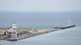
The Grand Marais Harbor of Refuge Inner and Outer Lights are a pair of lighthouses located on the west pier at the entry to Grand Marais Harbor of Refuge, in Grand Marais, Michigan. They were listed on the National Register of Historic Places in 2012.

