
Towson is an unincorporated community and a census-designated place in Baltimore County, Maryland, United States. The population was 55,197 as of the 2010 census. It is the county seat of Baltimore County and the second-most populous unincorporated county seat in the United States.

Mount Vernon is a neighborhood of Baltimore, Maryland, located immediately north of the city's downtown. It is named for George Washington's Mount Vernon estate in Virginia, as the site of the city's Washington Monument.

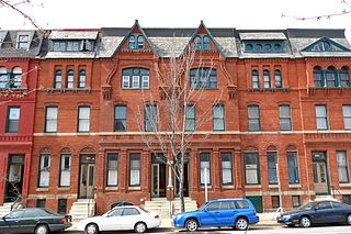
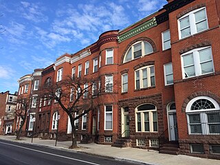
Charles Village is a neighborhood located in the north-central area of Baltimore, Maryland, USA. It is a diverse, eclectic, international, largely middle-class area with many single-family homes that is in proximity to many of Baltimore's cultural amenities. Nearby are the Baltimore Museum of Art, The Homewood campus of The Johns Hopkins University, Olmstead's Wyman Park, and the weekly Waverly Farmers Market, and the arts district, Station North. Homes are exemplary Baltimore brick and stone row houses, many dating from the 1890s. Running from downtown north is the historic boulevard, Charles Street, where Baltimore's Easter Promenade once took place.

The Washington Monument is the centerpiece of intersecting Mount Vernon Place and Washington Place, an urban square in the Mount Vernon-Belvedere neighborhood north of downtown Baltimore, Maryland. It was the first major monument to honor George Washington (1732–1799).
The Station North Arts and Entertainment District is an area and official arts and entertainment district in the U.S. city of Baltimore, Maryland. The neighborhood is marked by a combination of artistically-leaning commercial ventures, such as theaters and museums, as well as formerly abandoned warehouses that have since been converted into loft-style living. It is roughly triangular, bounded on the north by 20th Street, on the east by Greenmount Avenue, and on the south and west by the tracks of Amtrak's Northeast Corridor, though the neighborhood's boundaries include a one-block wide extension over the tracks.

Hamilton Hills is a mixed-use suburban neighborhood located in the northeastern corner of Baltimore City, Maryland. Hamilton Hills represents a section of Hamilton, a larger historic area that includes other neighborhoods in Northeast Baltimore. The neighborhood's borders are Old Harford Road and Harford Road to the east, Echodale Avenue to the south, Perring Parkway to the west and the Baltimore County line to the north. The main thoroughfare in Hamilton Hills is Harford Road, which has been an integral part of the area's history.
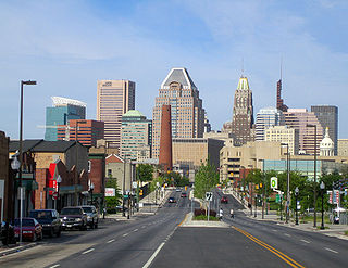
Downtown Baltimore is the central business district of the city of Baltimore traditionally bounded by Martin Luther King, Jr. Boulevard to the west, Franklin Street to the north, President Street to the east and the Inner Harbor area to the south.

Park Heights is an area of Baltimore City, Maryland, that lies approximately 5 miles northwest of downtown Baltimore and within two miles of the Baltimore County line. A 1,500-acre community, Park Heights comprises 12 smaller neighborhoods that together contain approximately 30,000 residents. It is bounded on the south by Druid Park Drive, on the west by Wabash Avenue, on the east by Greenspring Avenue, and on the north by Northern Parkway. Interstate-83 is less than a half mile to the east. Two major roadways—Park Heights Avenue and Reisterstown Road—run north-south through Park Heights, serving as the neighborhood's "Main Streets" as well as commuter corridors. Limited commercial uses—primarily retail—are scattered along these roads; there is also some industrial activity on the neighborhood's western edge.
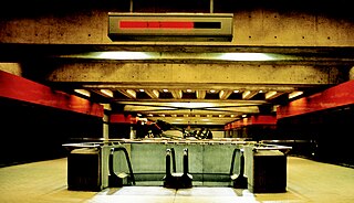
State Center / Cultural Center station is an underground Metro SubwayLink station in Baltimore, Maryland. It is a transit hub offering connections to Light RailLink, the tenth most northern and western station on the line, the first one in the area viewed by many as "downtown Baltimore," and is within a 2 block walk of the Cultural Center / State Center station on the Baltimore Light Rail via Preston Street, and many area landmarks.

The Belvedere is a Beaux Arts style building in Baltimore, Maryland. Designed by the Boston architectural firm of Parker and Thomas and built in 1902–1903, the Belvedere is a Baltimore City Landmark at the southeast corner of North Charles Street, facing north on East Chase Street in the city's fashionable Mount Vernon-Belvedere-Mount Royal neighborhood. In 1991 it was converted into condominiums, though areas remain open to the public.
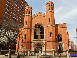
Franklin Street Presbyterian Church and Parsonage is a historic Presbyterian church located at 100 West Franklin Street at Cathedral Street, northwest corner in Baltimore, Maryland, United States. The church is a rectangular Tudor Gothic building dedicated in 1847, with an addition in 1865. The front features two 60 foot flanking octagonal towers are also crenelated and have louvered belfry openings and stained glass Gothic-arched windows. The manse / parsonage at the north end has similar matching walls of brick, heavy Tudor-Gothic window hoods, and battlements atop the roof and was built in 1857.

Leadenhall Street Baptist Church is a historic Baptist church located at Baltimore, Maryland, United States. It is a gable-front rectangular brick temple with simple Renaissance Revival detail. The original exterior wall surfaces have been covered with formstone on the main façade and stucco elsewhere. It features round-arched stained glass windows on each side bay. It was built in 1873, by Joseph Thomas & Son for the city's African American Baptists who were then centered in the old southwest area from the downtown business district of Baltimore in the "Sharp-Leadenhall" community in the old "South Baltimore" area. Nearby is its now famed revitalized "Inner Harbor" area of the old "Basin" for the harbor port.
James Lawrence Kernan (1838–1912) was a theater manager and philanthropist based in Baltimore, Maryland.

Baltimore is the most populous city in the U.S. state of Maryland. With a population of 585,708 at the 2020 census, it is the 30th-most populous city in the United States. Baltimore was designated an independent city by the Constitution of Maryland in 1851, and today it is the most populous independent city in the nation. As of the 2020 census, the population of the Baltimore metropolitan area was estimated to be 2,838,327, making it the 20th-largest metropolitan area in the country. When combined with the larger Washington metropolitan area, the Washington–Baltimore combined statistical area (CSA) has a 2020 U.S. census population of 9,973,383, the third-largest in the country.

Baltimore Heritage is an American nonprofit historic-preservation organization headquartered in Baltimore, Maryland.
Madison Park is a neighborhood in west Baltimore.

The history of White Americans in Baltimore dates back to the 17th century when the first white European colonists came to what is now Maryland and established the Province of Maryland on what was then Native American land. White Americans in Baltimore are Baltimoreans "having origins in any of the original peoples of Europe, the Middle East or North Africa." Majority white for most of its history, Baltimore no longer had a white majority by the 1970s. As of the 2010 census, white Americans are a minority population of Baltimore at 29.6% of the population. White Americans have played a substantial impact on the culture, dialect, ethnic heritage, history, politics, and music of the city. Since the earliest English settlers arrived on the shores of the Chesapeake Bay, Baltimore's white population has been sustained by substantial immigration from all over Europe, particularly Central Europe, Eastern Europe, and Southern Europe, as well as a large out-migration of White Southerners from Appalachia. Numerous white immigrants from Europe and the European diaspora have immigrated to Baltimore from the United Kingdom, Germany, Ireland, Poland, Italy, the Czech Republic, Slovakia, Lithuania, Russia, Ukraine, Spain, France, Canada, and other countries, particularly during the late 19th century and early 20th century. Smaller numbers of white people have immigrated from Latin America, the Caribbean, the Middle East, North Africa, and other non-European regions. Baltimore also has a prominent population of white Jews of European descent, mostly with roots in Central and Eastern Europe. There is a smaller population of white Middle Easterners and white North Africans, most of whom are Arab, Persian, Israeli, or Turkish. The distribution of White Americans in Central and Southeast Baltimore is sometimes called "The White L", while the distribution of African Americans in East and West Baltimore is called "The Black Butterfly."

The National Council of Young Men's Christian Associations of the United States of America is part of the worldwide youth organization YMCA. It has 2,700 separate organizations with 10,000 branches working with 21 million men, women and children, to "strengthen communities through youth development, healthy living and social responsibility." It employs 19,000 staff and is supported by 600,000 volunteers, and YMCA branches have about 10,000 service locations. The first YMCA in the United States opened on December 29, 1851, in Boston, Massachusetts. It was founded in 1851 by Captain Thomas Valentine Sullivan (1800–59), an American seaman and missionary.


