Mount Vernon is a neighborhood of Baltimore, Maryland, located immediately north of the city's downtown district. Designated a city Cultural District, it is one of the oldest neighborhoods originally home to the city's wealthiest and most fashionable families. The name derives from Mount Vernon, the home of George Washington, given the original Washington Monument, a massive pillar commenced in 1815 to commemorate the first president of the United States, is the defining feature of the neighborhood.

Charles Village is a neighborhood located in the north-central area of Baltimore, Maryland, USA. It is a diverse, eclectic, international, largely middle-class area with many single-family homes that is in proximity to many of Baltimore's cultural amenities. Nearby are the Baltimore Museum of Art, The Homewood campus of The Johns Hopkins University, Olmstead's Wyman Park, and the weekly Waverly Farmers Market, and the arts district, Station North. Homes are exemplary Baltimore brick and stone row houses, many dating from the 1890s. Running from downtown north is the historic boulevard, Charles Street, where Baltimore's Easter Promenade once took place.

Hamilton Hills is a mixed-use suburban neighborhood located in the northeastern corner of Baltimore City, Maryland. Hamilton Hills represents a section of Hamilton, a larger historic area that includes other neighborhoods in Northeast Baltimore. The neighborhood's borders are Old Harford Road and Harford Road to the east, Echodale Avenue to the south, Perring Parkway to the west and the Baltimore County line to the north. The main thoroughfare in Hamilton Hills is Harford Road, which has been an integral part of the area's history.

Charles Street, known for most of its route as Maryland Route 139, runs through Baltimore City and through the Towson area of Baltimore County. On the north end it terminates at an intersection with Bellona Avenue near Interstate 695 (I-695) and at the south end it terminates in Federal Hill in Baltimore. Charles Street is one of the major routes through the city of Baltimore, and is a major public transportation corridor. For the one-way portions of Charles Street, the street is functionally complemented by the parallel St. Paul Street, Maryland Avenue, Cathedral Street, and Liberty Street.

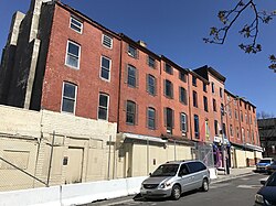
Barre Circle is a small neighborhood in Baltimore, Maryland, United States. It is often considered to be a part of Pigtown. Most of the neighborhood's historic homes range from 1840 to 1890, with many populated by graduate students at the nearby University of Maryland's Baltimore campus. It is walking distance to the Inner Harbor and the MARC Train's Camden Station.
Glen is a neighborhood in Baltimore, Maryland. It was developed in the early 1920s and 1930s, with the remaining development coming in the 1940s through the 1960s. Glen is one of the largest communities of Northern Park Heights in Baltimore. Glen is a neighborhood of mixed housing types that include Tudor, French Norman and brick ranch houses, along with garden apartments, condominiums and semi-detached single family homes.
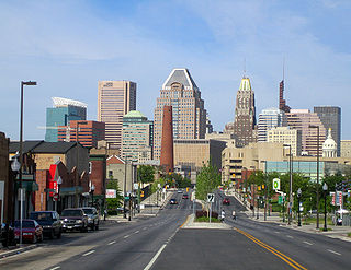
Downtown Baltimore is the central business district of the city of Baltimore traditionally bounded by Martin Luther King, Jr. Boulevard to the west, Franklin Street to the north, President Street to the east and the Inner Harbor area to the south.

Coppin Heights is a neighborhood in the western part of Baltimore, Maryland. Located above North Avenue, it is a working-class neighborhood home to Coppin State University.

Radnor-Winston is a small community centered near the intersection of York Road and Winston Ave in the North District of Baltimore. Radnor Winston is a friendly, affordable and diverse neighborhood of about 220 homes tucked behind the campuses of Loyola University and The College of Notre Dame. Located in the Roland Park Public School district, the neighborhood is convenient to both downtown Baltimore and Towson.
Ashburton is a wealthy, predominantly African-American neighborhood in the Forest Park region of northwestern Baltimore City, Maryland. It is located near Liberty Heights Avenue and Hilton Street, and is characterized by a few large Victorian mansions interspersed among row houses.

Medfield is a neighborhood located in north Baltimore, Maryland, United States of America. It is located to the north of the trendy Hampden neighborhood and south of affluent Roland Park neighborhood. Its unofficial boundaries are Coldspring Lane to the north; Jones Falls Expressway to the west; Falls Road/Hickory Avenue to the east; and West 41st Street to the south.

Mosher is a neighborhood in the western part of Baltimore, Maryland. Its boundaries are the north side of Edmondson Avenue, the west side of Braddish Avenue, the east side of Poplar Grove, and the south side of Riggs Avenue. The neighborhood lies in the vicinity of Walbrook Junction, Coppin State University, Sandtown-Winchester, and Edmondson Village. Mosher is one of several neighborhoods that resisted the development of the "Road to Nowhere", now designated as US 40, along the Franklin Avenue corridor. The area was historically segregated, and largely occupied by European Americans, but transitioned during the early 1950s to become a predominantly African American area.
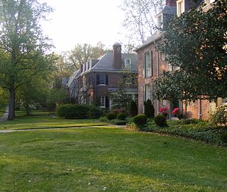
Guilford is a prominent and historic neighborhood located in the northern part of Baltimore, Maryland. It is bounded on the south by University Parkway, on the west by North Charles Street, Warrenton and Linkwood Roads, on the north by Cold Spring Lane and on the east by York Road. The neighborhood is adjacent to the neighborhoods of Tuscany-Canterbury, Loyola-Notre Dame, Kernewood, Wilson Park, Pen Lucy, Waverly Oakenshawe, Charles Village, and the universities of Johns Hopkins and Loyola University Maryland. The neighborhood was added to the National Register of Historic Places in 2001.

Baltimore is the most populous city in the U.S. state of Maryland, fourth most populous city in the Mid-Atlantic, and the 30th most populous city in the United States with a population of 585,708 in 2020. Baltimore was designated an independent city by the Constitution of Maryland in 1851, and today is the most populous independent city in the United States. As of 2021, the population of the Baltimore metropolitan area was estimated to be 2,838,327, making it the 20th largest metropolitan area in the country. Baltimore is located about 40 miles (64 km) north northeast of Washington, D.C., making it a principal city in the Washington–Baltimore combined statistical area (CSA), the third-largest CSA in the nation, with a 2021 estimated population of 9,946,526.
Callaway-Garrison is a neighborhood in the Northwest district of Baltimore, located between the neighborhoods of Dorchester (west) and Ashburton (east). Its boundaries are marked by West Cold Spring Lane (north), Liberty Heights Avenue (south), Callaway Avenue (east) and Garrison Boulevard (west).

Hollins Market is a neighborhood in the Sowebo area of Baltimore. It takes its name from the Hollins Market, the oldest public market building still in use in Baltimore City, which is located in the heart of the neighborhood.

Loyola-Notre Dame is a neighborhood located in Baltimore, Maryland. The neighborhood is named after the two universities that occupy most of the area: Notre Dame of Maryland University and Loyola University Maryland. The neighborhood is also home to the Evergreen House owned by Johns Hopkins University. The neighborhood covers all the area owned by the two universities and Evergreen House. The neighborhood does not cover a uniform area, but does have a relative definition. The northern boundary is Homeland Avenue. The eastern boundary varies among Millbrook Road, Underwood Road and other small streets. The Radnor Village, Thomas Aquinas Hall, and Loyola Public system are also included in the neighborhood despite being separated from the rest of the Loyola campus by the Radnor-Winston and Villages of Homeland neighborhoods. The southern border is Cold Spring Lane and the western border is primarily North Charles Street. Loyola extends via a pedestrian bridge over North Charles Street along Cold Spring Lane to Stony Run stream. The Loyola Fitness and Aquatics center is also across North Charles Street. The neighborhood is unique in having a very small permanent population, but housing over 4,000 students.

Westside Baltimore is the western portion of downtown Baltimore that includes Market Center and many of the newest developments in downtown Baltimore. It has increasingly become the preferred residential section of downtown. It is also home to the site of the "Superblock" project that will include hundreds of condos and apartments as well as a variety of retail and commercial space. The former home of Baltimore's many and famed department stores, Westside Baltimore is now anchored by the University of Maryland, Baltimore consisting of the University of Maryland Health System, University of Maryland School of Law and the University of Maryland Biopark. The Westside is also home to several performing arts centers, including the Hippodrome Theatre, Royal Farms Arena and the future home of the Everyman Theatre.
Better Waverly is a neighborhood in the North District of Baltimore, located between the neighborhoods of Charles Village (west) and Coldstream-Homestead-Montebello (east). Its boundaries are marked by East 33rd Street (north), Exeter Hall Avenue (south), Greenmount Avenue (west) and Loch Raven Road (east).

The West Baltimore Innovation Village District is a neighborhood district of Baltimore City that will specialize in attracting startup companies and other employers to West Baltimore. Following the Death of Freddie Gray and the subsequent 2015 Baltimore protests, government leaders decided to launch the innovation district as a way to attract redevelopment and revitalization to the areas hardest hit by the protests. The district includes the neighborhoods of Mondawmin, Coppin Heights, Penn-North, Reservoir Hill and Bolton Hill.