
Fell's Point is a historic waterfront neighborhood in southeastern Baltimore, Maryland. It was established around 1763 along the north shore of the Baltimore Harbor and the Northwest Branch of the Patapsco River. The area has many antique, music, and other stores, restaurants, coffee bars, a municipal markethouse with individual stalls, and over 120 pubs. Located 1.5 miles east of Baltimore's downtown central business district and the Jones Falls stream, Fells Point has a maritime past and the air of a seafaring town. It also has the greatest concentration of drinking establishments and restaurants in the city.

Hampden is a neighborhood located in northern Baltimore, Maryland, United States. Roughly triangular in shape, it is bounded to the east by the neighborhood Wyman Park, to the north by Roland Park at 40th and 41st Street, to the west by the Jones Falls Expressway, and to the south by the neighborhood Remington. The Homewood campus of the Johns Hopkins University is a short distance to the east.

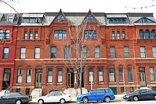
Mount Vernon is a neighborhood of Baltimore, Maryland, located immediately north of the city's downtown district. Designated a city Cultural District, it is one of the oldest neighborhoods originally home to the city's wealthiest and most fashionable families. The name derives from Mount Vernon, the home of George Washington, given the original Washington Monument, a massive pillar commenced in 1815 to commemorate the first president of the United States, is the defining feature of the neighborhood.

Charles Village is a neighborhood located in the north-central area of Baltimore, Maryland, USA. It is a diverse, eclectic, international, largely middle-class area with many single-family homes that is in proximity to many of Baltimore's cultural amenities. Nearby are the Baltimore Museum of Art, The Homewood campus of The Johns Hopkins University, Olmstead's Wyman Park, and the weekly Waverly Farmers Market, and the arts district, Station North. Homes are exemplary Baltimore brick and stone row houses, many dating from the 1890s. Running from downtown north is the historic boulevard, Charles Street, where Baltimore's Easter Promenade once took place.

Canton is a historic waterfront neighborhood in Baltimore, Maryland, United States. The neighborhood is along Baltimore's outer harbor in the southeastern section of the city, roughly two miles east of Baltimore's downtown district and next to or near the neighborhoods of Patterson Park, Fell's Point, Highlandtown, and Brewers Hill.

Cherry Hill is one of the southernmost neighborhoods in Baltimore, Maryland.

"Pigtown", also known as "Washington Village" is a neighborhood in the southwest area of Baltimore, bordered by Martin Luther King Jr. Boulevard to the east, Monroe Street to the west, Russell Street to the south, and West Pratt Street to the north. The neighborhood acquired its name during the second half of the 19th century, when the area was the site of butcher shops and meat packing plants to process pigs transported from the Midwest on the B&O Railroad; they were herded across Ostend and Cross Streets to be slaughtered and processed.
The Station North Arts and Entertainment District is an area and official arts and entertainment district in the U.S. city of Baltimore, Maryland. The neighborhood is marked by a combination of artistically-leaning commercial ventures, such as theaters and museums, as well as formerly abandoned warehouses that have since been converted into loft-style living. It is roughly triangular, bounded on the north by 20th Street, on the east by Greenmount Avenue, and on the south and west by the tracks of Amtrak's Northeast Corridor, though the neighborhood's boundaries include a one-block wide extension over the tracks.

Upton is a neighborhood in Baltimore City, Maryland, United States. The neighborhood is in the western section of the city, roughly between Fremont Avenue and McCulloh Street, extending from Dolphin Street to Bloom Street. Its principal thoroughfare is Pennsylvania Avenue.

Hamilton Hills is a mixed-use suburban neighborhood located in the northeastern corner of Baltimore City, Maryland. Hamilton Hills represents a section of Hamilton, a larger historic area that includes other neighborhoods in Northeast Baltimore. The neighborhood's borders are Old Harford Road and Harford Road to the east, Echodale Avenue to the south, Perring Parkway to the west and the Baltimore County line to the north. The main thoroughfare in Hamilton Hills is Harford Road, which has been an integral part of the area's history.

Park Heights is an area of Baltimore City, Maryland, that lies approximately 10 miles northwest of downtown Baltimore and within two miles of the Baltimore County line. A 1,500-acre community, Park Heights comprises 12 smaller neighborhoods that together contain approximately 30,000 residents. It is bounded on the south by Druid Park Drive, on the west by Wabash Avenue, on the east by Greenspring Avenue, and on the north by Northern Parkway. Interstate-83 is less than a half mile to the east. Two major roadways—Park Heights Avenue and Reisterstown Road—run north-south through Park Heights, serving as the neighborhood's "Main Streets" as well as commuter corridors. Limited commercial uses—primarily retail—are scattered along these roads; there is also some industrial activity on the neighborhood's western edge.

Greenmount West is a neighborhood in the state-designated Station North Arts District of Baltimore City. Its borders consist of Hargrove Alley to the west, Hoffman Street and the Amtrak railroad tracks to the south, the south side of North Avenue to the north, and Greenmount Avenue to the east. Residents in the area include a mix of low, middle and high income families, artists, commuters to Washington DC and working-class Baltimoreans with the majority of residents of African American descent.
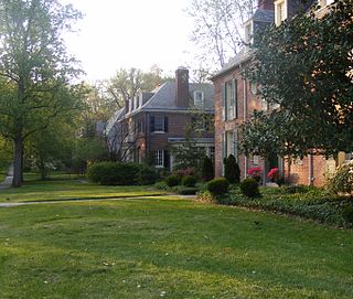
Guilford is a prominent and historic neighborhood located in the northern part of Baltimore, Maryland. It is bounded on the south by University Parkway, on the west by North Charles Street, Warrenton and Linkwood Roads, on the north by Cold Spring Lane and on the east by York Road. The neighborhood is adjacent to the neighborhoods of Tuscany-Canterbury, Loyola-Notre Dame, Kernewood, Wilson Park, Pen Lucy, Waverly Oakenshawe, Charles Village, and the universities of Johns Hopkins and Loyola University Maryland. The neighborhood was added to the National Register of Historic Places in 2001.

Baltimore is the most populous city in the U.S. state of Maryland, fourth most populous city in the Mid-Atlantic, and the 30th most populous city in the United States with a population of 585,708 in 2020. Baltimore was designated an independent city by the Constitution of Maryland in 1851, and today is the most populous independent city in the United States. As of 2021, the population of the Baltimore metropolitan area was estimated to be 2,838,327, making it the 20th largest metropolitan area in the country. Baltimore is located about 40 miles (64 km) north northeast of Washington, D.C., making it a principal city in the Washington–Baltimore combined statistical area (CSA), the third-largest CSA in the nation, with a 2021 estimated population of 9,946,526.
Frankford is a neighborhood in northeast Baltimore. Frankford is the most populous of the city's designated neighborhoods, with over 17,000 residents.

East Monument Historic District or Little Bohemia, is a national historic district in Baltimore, Maryland. It is a large residential area with a commercial strip along East Monument Street. It comprises approximately 88 whole and partial blocks. The residential area is composed primarily of rowhomes that were developed, beginning in the 1870s, as housing for Baltimore's growing Bohemian (Czech) immigrant community. During the late 19th and early 20th centuries the neighborhood was the heart of the Bohemian community in Baltimore. The Bohemian National Parish of the Roman Catholic Church, St. Wenceslaus, is located in the neighborhood. The historic district includes all of McElderry Park and Milton-Montford, most of Middle East and Madison-Eastend, and parts of Ellwood Park.

Hollins–Roundhouse Historic District is a national historic district in Baltimore, Maryland, United States. It is a primarily residential area characterized by 19th century rowhouses. The neighborhood is historically significant due to its association with the development of rail transportation in Maryland. Additional historical significance comes from the neighborhood's association with ethnic immigration to Baltimore. During the 1840s and 1850s the area was a center of settlement for Baltimore's German and Irish communities, many of whom immigrated to the United States to work in the rail industry. Later, from the 1880s to the 1920s, the neighborhood became established as the center of Baltimore's Lithuanian immigrant community. Because of the large Lithuanian population in the area north of Hollins Street, the area became known as Little Lithuania. A few remnants of the neighborhood's Lithuanian heritage still remain, such as Lithuanian Hall located on Hollins Street.

Poppleton is a neighborhood in west Baltimore, Maryland. The neighborhood is bounded on the north by West Mulberry Street, on the south by West Baltimore Street, on the west by North Carey Street, and on the east by the Martin Luther King Jr. Boulevard. Previously, Poppleton was construed in a broader sense extending further south to West Pratt Street or Lombard Street, but today this area is commonly described as the separate neighborhood of Hollins Market.

Hollins Market is a neighborhood in the Sowebo area of Baltimore. It takes its name from the Hollins Market, the oldest public market building still in use in Baltimore City, which is located in the heart of the neighborhood.
