
Arbutus is an unincorporated community and a census-designated place in Baltimore County, Maryland, United States. The population was 20,483 at the 2010 census. The census area also contains the communities of Halethorpe and Relay, in which all three names were used during the 1960 census when the area had a population of 22,402.

Catonsville is a census-designated place (CDP) in Baltimore County, Maryland. The population was 44,701 at the 2020 US Census. The community is a streetcar suburb of Baltimore along the city's western border. The town is known for its proximity to the Patapsco River and Patapsco Valley State Park, making it a regional mountain biking hub. The town is also notable as a local hotbed of music, earning it the official nickname of "Music City, Maryland." Catonsville contains the majority of the University of Maryland, Baltimore County (UMBC), a major public research university with close to 14,000 students.

Elkridge is an unincorporated community and census-designated place (CDP) in Howard County, Maryland, United States. The population was 15,593 at the 2010 census. Founded early in the 18th century, Elkridge is adjacent to two other counties, Anne Arundel and Baltimore.

MARC is a commuter rail system in the Washington–Baltimore area. MARC is administered by the Maryland Transit Administration (MTA) and operated under contract by Alstom and Amtrak on track owned by CSX Transportation (CSXT) and Amtrak. In 2022, the system had a ridership of 2,815,900, or about 12,500 per weekday as of the second quarter of 2023, less than pre-COVID-19 pandemic weekday ridership of 40,000.

The Capital Subdivision is a railroad line owned and operated by CSX Transportation in the U.S. state of Maryland and the District of Columbia. The line runs from near Baltimore, Maryland, southwest to Washington, D.C., along the former Baltimore and Ohio Rail Road (B&O) Washington Branch. The subdivision's Alexandria Extension provides a connection to Virginia and points south.

Lansdowne is a census-designated place in southern Baltimore County, Maryland, United States, located just south of Baltimore. As of the 2010 census, it had a population of 8,409. At the 2000 census and earlier, the area was delineated as part of the Lansdowne-Baltimore Highlands CDP.

U.S. Route 1 (US 1) is the easternmost and longest of the major north–south routes of the older 1920s era United States Numbered Highway System, running from Key West, Florida, to Fort Kent, Maine. In the U.S. state of Maryland, it runs 81 miles (130 km) from the Washington, D.C. line to the Pennsylvania state line near the town of Rising Sun.
Halethorpe is an unincorporated community in Baltimore County, Maryland, United States. The community is considered to be a sub-section of Arbutus by the United States Census Bureau. It is bordered by the main portion of Arbutus to the north, Baltimore to the North East, Elkridge to the South West, and Linthicum to the East. It is southeast of the University of Maryland, Baltimore County.

Aberdeen station is a train station in Aberdeen, Maryland, on the Northeast Corridor. It is served by Amtrak Northeast Regional intercity service and MARC Penn Line commuter service. The station has two side platforms serving the outer tracks of the three-track Northeast Corridor, with a station building on the north side of the tracks.
Relay, Maryland, or Relay House, Maryland, was formerly an important junction and rail stop on the Baltimore and Ohio Railroad, located 9 miles (14 km) west of Baltimore, Maryland. It was the busiest station on the line except for Baltimore itself. A town grew up around it: a general store, a school, and a volunteer fire company. Although the neighborhood is still inhabited, only the ghost of the town survives. There is no longer town government, a post office, nor are there any stores. The former fire house, at 1710 Arlington Avenue, at one point the town hall, has survived and is available for rental for events. In 2021 Relay is a historic district of Halethorpe, Maryland, near the intersection of today's Viaduct and Railroad Avenues. There is a Relay Elementary School.

Maryland Route 166 is a state highway in the U.S. state of Maryland. The state highway runs 2.71 miles (4.36 km) from Interstate 195 (I-195) in Arbutus north to MD 144 in Catonsville. MD 166 consists of two sections: a short freeway section that serves as a northern continuation of I-195 and provides access to the University of Maryland, Baltimore County (UMBC), and a segment of Rolling Road, a major north–south highway in western Baltimore County. Rolling Road dates to the colonial era as a highway used to transport tobacco from plantations to river ports. North Rolling Road, which connects Catonsville with Woodlawn and Milford Mill, has always been a county highway. South Rolling Road was constructed as a state highway by the early 1920s between what were to become U.S. Route 1 and US 40. Parts of South Rolling Road were transferred to county maintenance after they were severed by the construction of I-95 and a freeway relocation of the southern end of MD 166 in the early 1970s.

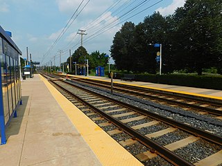
Patapsco station is a Baltimore Light Rail station in Halethorpe, Maryland. The stop is located along Patapsco Avenue from which its name is derived. The station serves as a hub for several MTA bus routes. Patapsco was the final stop along the line for a period from September 1992 until April 1993, when the line was extended to Linthicum.

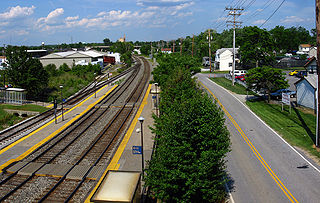
Halethorpe station is a passenger rail station located in the unincorporated community of Halethorpe, Maryland on the Northeast Corridor. MARC Penn Line trains serve the station; Amtrak trains pass through but do not stop.
Savage is a passenger rail station on the MARC Camden Line between Union Station and Baltimore's Camden Station. It is officially located at 9009 Dorsey Run Road in Savage, Maryland, however Dorsey Run Road runs over the railroad tracks as well as Brock Bridge Road, which runs along the south side of the tracks and is a street-level with the station. The station straddles the line between Howard County and Anne Arundel County, with the southbound platform and parking garage located in Howard County and the northbound platform in Anne Arundel County.

St. Denis station is a passenger rail station on the MARC Camden Line in the Maryland town of the same name. While the small station is the line's closest station to its terminus at Camden Yards in Baltimore, it has low ridership.
Baltimore Highlands station is a Baltimore Light Rail stop in Halethorpe, Maryland. There are currently 50 free parking spaces. There are no bus connections at this station.

Route 77 is a bus route operated by the Maryland Transit Administration in the suburbs of Baltimore. The line currently runs from the Old Court Metro Subway Station in Pikesville, Maryland, to the Patapsco Light Rail Stop and serves Randallstown, Windsor Mill, Woodlawn, Catonsville, Arbutus, Halethorpe, and Lansdowne as well as the campuses of UMBC and CCBC Catonsville.

The Baltimore Terminal Subdivision is a railroad line owned and operated by CSX Transportation in the U.S. state of Maryland. The line runs from Baltimore to Halethorpe along the original Baltimore and Ohio Railroad (B&O) line, one of the oldest rail lines in the United States and the first passenger railroad line. At its east (north) end, it connects with the Philadelphia Subdivision; its west (south) end has a junction with the Capital Subdivision and the Old Main Line Subdivision.
U.S. Route 1 Alternate is an alternate route of US 1 in the U.S. state of Maryland. The highway runs 3.92 miles (6.31 km) between intersections with US 1 in Arbutus and in Baltimore. US 1 Alt. serves the southwestern Baltimore County community of Halethorpe and connects US 1 with full-access interchanges with Interstate 95 (I-95) and I-695. The Washington Boulevard portion of the alternate route was the original road southwest from Baltimore in the 18th century and was part of the turnpike southwest to Washington, D.C. for much of the 19th century. The highway was paved in the early 1910s, expanded in the late 1910s and late 1920s, and became part of US 1 in 1926. The Caton Avenue portion of the alternate route was improved and expanded in the 1930s to serve as a rerouting of US 1 in southwest Baltimore. US 1 Alt. was created in 1949 when US 1 was moved to its present course through Arbutus and southwest Baltimore. The alternate route's interchanges with I-695 and I-95 were constructed in the late 1950s and mid-1970s, respectively.
UMBC Transit is the official bus system of the University of Maryland, Baltimore County. Along with the Maryland Transit Administration (MTA), the UMBC community has public transit access to nearby areas such as Catonsville, Arbutus, Maryland, and Baltimore City.


