Shenandoah County, Virginia

Last updated

Shenandoah County
Shenandoah County Courthouse, new.jpg
Shenandoah County Courthouse in Woodstock
Flag of Shenandoah County, Virginia.png
Shenandoah County Seal 2023.png
Shenandoah Logo Be Inspired.png
Map of Virginia highlighting Shenandoah County.svg
Location within the U.S. state of Virginia
Virginia in United States.svg
Virginia's location within the U.S.
Coordinates: 38°52′N78°34′W / 38.86°N 78.57°W / 38.86; -78.57
CountryFlag of the United States.svg United States
StateFlag of Virginia.svg  Virginia
Founded1772
Named for Shenandoah River
Seat Woodstock
Largest town Strasburg
Area
  Total512 sq mi (1,330 km2)
  Land509 sq mi (1,320 km2)
  Water3.4 sq mi (9 km2)  0.7%
Population
 (2020)
  Total44,186
  Density86/sq mi (33/km2)
Time zone UTC−5 (Eastern)
  Summer (DST) UTC−4 (EDT)
Congressional district 6th
Website www.shenandoahcountyva.us

Shenandoah County (formerly Dunmore County) is a county located in the Commonwealth of Virginia. As of the 2020 United States Census, the population was 44,186. [1] Its county seat is Woodstock. [2] It is part of the Shenandoah Valley region of Virginia.

Contents

History

The Senedos, possibly an Iroquoian group, are thought to have occupied the area at one time, until they were said to have been slaughtered by the Catawba in the latter 17th century. The name of the Valley, and of the county, is most likely connected with this Native American group. It has also been attributed to General George Washington naming it in honor of John Skenandoa, an Oneida chief from New York who helped gain support of Oneida and Tuscarora warriors to aid the rebel colonists during the American Revolutionary War.

Colonial Governor Gooch formally purchased the entire Shenandoah Valley from the Six Nations of the Iroquois by the Treaty of Lancaster in 1744. The Iroquois had controlled the valley as a hunting ground, but European settlement had begun by that time. During Pontiac's War (1763–1766), Shawnee efforts to repel the white intruders reached as far east as the current county.

The county was established in 1772 as 'Dunmore County' for Virginia Colonial Governor John Murray, 4th Earl of Dunmore. Woodstock was designated the county seat. Dunmore was Virginia's last royal governor, and was forced from office during the American Revolution. During the war (1778), the rebels renamed the county 'Shenandoah.'

During the Civil War, the Battle of New Market took place in the county on May 15, 1864.

Geography

Harrisonburg to Frederick.svg
Shenandoah
Shenandoah and adjacent counties

According to the US Census Bureau, the county has a total area of 512 square miles (1,330 km2), of which 509 square miles (1,320 km2) is land and 3.4 square miles (8.8 km2) (0.7%) is water. [3] Fort Valley and the western slopes of the Massanutten Mountain are located within the county boundary.

Adjacent counties

National protected areas

Transportation

I-81 southbound in Shenandoah County 2019-07-09 09 19 32 View south along Interstate 81 from the overpass for Virginia State Route 767 (Quicksburg Road) in Quicksburg, Shenandoah County, Virginia.jpg
I-81 southbound in Shenandoah County

Major highways

Demographics

Historical population
CensusPop.Note
1790 10,510
1800 13,82331.5%
1810 13,646−1.3%
1820 18,92638.7%
1830 19,7504.4%
1840 11,618−41.2%
1850 13,76818.5%
1860 13,8960.9%
1870 14,9367.5%
1880 18,20421.9%
1890 19,6718.1%
1900 20,2533.0%
1910 20,9423.4%
1920 20,808−0.6%
1930 20,655−0.7%
1940 20,8981.2%
1950 21,1691.3%
1960 21,8253.1%
1970 22,8524.7%
1980 27,55920.6%
1990 31,63614.8%
2000 35,07510.9%
2010 41,99319.7%
2020 44,1865.2%
US Decennial Census [4]
1790–1960 [5] 1900–1990 [6]
1990–2000 [7] 2010 [8] 2020 [9]

2020 census

Shenandoah County, Virginia - Demographic Profile
(NH = Non-Hispanic)
Race / EthnicityPop 2010 [8] Pop 2020 [9] % 2010% 2020
White alone (NH)37,88637,30490.22%84.42%
Black or African American alone (NH)6991,0311.66%2.33%
Native American or Alaska Native alone (NH)71840.17%0.19%
Asian alone (NH)2103440.50%0.78%
Pacific Islander alone (NH)680.01%0.02%
Some Other Race alone (NH)281490.07%0.34%
Mixed Race/Multi-Racial (NH)5161,5401.23%3.49%
Hispanic or Latino (any race)2,5773,7266.14%8.43%
Total41,99344,186100.00%100.00%

Note: the US Census treats Hispanic/Latino as an ethnic category. This table excludes Latinos from the racial categories and assigns them to a separate category. Hispanics/Latinos can be of any race.

2010 Census

As of the 2010 United States Census, there were 41,993 people in the county. 93.0% were White, 1.7% Black or African American, 0.5% Asian, 0.2% Native American, 2.8% of some other race and 1.6% of two or more races. 6.1% were Hispanic or Latino (of any race). 26.4% were of American, 22.0% German, 10.3% English and 7.6% Irish ancestry. [10]

2000 Census

As of the 2000 United States Census, [11] there were 35,075 people, 14,296 households, and 10,064 families in the county. The population density was 68 people per square mile (26 people/km2). There were 16,709 housing units at an average density of 33 per square mile (13/km2). The racial makeup of the county was 95.60% White, 1.17% Black or African American, 0.18% Native American, 0.35% Asian, 0.02% Pacific Islander, 1.79% from other races, and 0.89% from two or more races. 3.40% of the population were Hispanic or Latino of any race.

There were 14,296 households, out of which 28.10% had children under the age of 18 living with them, 57.00% were married couples living together, 9.30% had a female householder with no husband present, and 29.60% were non-families. 25.10% of all households were made up of individuals, and 11.30% had someone living alone who was 65 years of age or older. The average household size was 2.42 and the average family size was 2.86.

The county population contained 22.30% under the age of 18, 6.60% from 18 to 24, 27.60% from 25 to 44, 26.20% from 45 to 64, and 17.30% who were 65 years of age or older. The median age was 41 years. For every 100 females there were 94.90 males. For every 100 females age 18 and over, there were 92.80 males.

The median income for a household in the county was $39,173, and the median income for a family was $45,080. Males had a median income of $29,952 versus $22,312 for females. The per capita income for the county was $19,755. About 5.80% of families and 8.20% of the population were below the poverty line, including 12.10% of those under age 18 and 8.80% of those age 65 or over.

Education

Private

Secondary institutions

Primary institutions

  • Shenandoah Valley Adventist Elementary School
  • Valley Baptist Christian School

Public

High schools

Elementary and middle schools

  • W.W. Robinson Elementary School (Woodstock)
  • Peter Muhlenberg Middle School (Woodstock)
  • Ashby-Lee Elementary School (Quicksburg)
  • North Fork Middle School (Quicksburg)
  • Sandy Hook Elementary School (Strasburg)
  • Signal Knob Middle School (Strasburg)

Other

  • Triplett Tech (Mount Jackson)
  • Massanutten Regional Governor's School (High School level, in Mount Jackson)

Communities

Towns

Census-designated places

Other unincorporated communities

Law enforcement

Shenandoah County Sheriff's Office
AbbreviationSCSO
Agency overview
FormedMay 26, 1772
Employees100+
Jurisdictional structure
Constituting instrument
  • Yes
General nature
Operational structure
Headquarters Woodstock, Virginia
Agency executive
Website
Official Website

The Shenandoah County Sheriff's Office (SCSO) is the primary law enforcement agency in Shenandoah County. The SCSO was created on May 26, 1772, when the position of High Sheriff position was created; its main duty was to collect taxes. [12]

The SCSO was accredited by the Virginia Law Enforcement Professional Standards Commission between 2006, when it first became accredited, and 2022, when it lost accreditation following an evaluation. [13]

Politics

Politically, Shenandoah County is one of the most consistently Republican counties in Virginia, a trend that predates the rest of western Virginia moving away from the Democratic Party. It was first won by a Republican presidential nominee in 1896, and has voted Republican in every presidential election since 1936, and in all but one election since 1920. Nearly solidly Democratic before 1900, the county began voting Republican in statewide elections around the beginning of the 20th century but was a swing county. In the 1920s it became solidly Republican at a statewide level, with the exception of Democratic local hero Harry F. Byrd and his son. This early swing to the GOP came from the county’s rural voters being overwhelmingly German American Republicans, which overpowered the conservative Southern Democrat vote in the county population centers of New Market, Woodstock, and Strasburg. Virginia Constitutional Convention of 1902 was vehemently opposed by the counties of western Virginia due to the impact on racial equality and perceived disenfranchisement of the many poor whites of the region. The once strong Democratic county turned Republican due to this convention, which, according to the Shenandoah Herald, was the “…death knell of the Democratic party in the Valley counties.” The Democrats of the county were of the Jacksonian, small government stock; leading them to vote Republican after the perceived injustice by the state convention in the creation of a new constitution, [14] which was not ratified by popular vote. The county briefly returned to its Southern Democrat roots at the state level during the civil rights movement. [15]

In 1856, Shenandoah County was the only county in Virginia to record votes in favor of the candidate of the newly formed Republican Party, John C. Frémont.

United States presidential election results for Shenandoah County, Virginia [16]
Year Republican Democratic Third party
No.%No.%No.%
2020 16,46369.51%6,83628.86%3851.63%
2016 14,09468.72%5,27325.71%1,1415.56%
2012 12,53864.72%6,46933.39%3661.89%
2008 12,00562.45%6,91235.96%3061.59%
2004 11,82068.94%5,18630.25%1400.82%
2000 9,63666.68%4,42030.58%3962.74%
1996 7,44056.02%4,22431.81%1,61612.17%
1992 7,74655.74%3,95628.47%2,19415.79%
1988 8,61271.74%3,27627.29%1160.97%
1984 9,04876.03%2,77123.29%810.68%
1980 7,51767.10%3,13728.00%5494.90%
1976 6,29664.05%3,36434.22%1701.73%
1972 7,12882.46%1,42216.45%941.09%
1968 5,46162.91%1,65419.05%1,56618.04%
1964 3,98155.54%3,18444.42%30.04%
1960 4,14466.85%2,05333.12%20.03%
1956 4,16469.18%1,76929.39%861.43%
1952 4,28471.12%1,73428.78%60.10%
1948 3,34964.65%1,60330.95%2284.40%
1944 3,51764.12%1,96235.77%60.11%
1940 3,52758.87%2,45040.89%140.23%
1936 3,15252.29%2,86147.46%150.25%
1932 2,51448.19%2,63550.51%681.30%
1928 3,42068.28%1,58931.72%00.00%
1924 2,21448.80%2,18648.18%1373.02%
1920 2,68356.05%2,07743.39%270.56%
1916 1,42548.70%1,44049.21%612.08%
1912 70627.61%1,33652.25%51520.14%

See also

Related Research Articles

<span class="mw-page-title-main">Frederick County, Virginia</span> County in Virginia, United States

Frederick County is located in the Commonwealth of Virginia. As of the 2020 census, the population was 91,419. Its county seat is Winchester. The county was formed in 1743 by the splitting of Orange County. It is Virginia's northernmost county. Frederick County is included in the Winchester, VA-WV Metropolitan Statistical Area, which is also included in the Washington-Baltimore-Northern Virginia, DC-MD-VA-WV-PA Combined Statistical Area.

<span class="mw-page-title-main">Greene County, Virginia</span> County in Virginia, United States

Greene County is a county in Virginia in the eastern United States. As of the 2020 census, the population was 20,552. Its county seat is Stanardsville.

<span class="mw-page-title-main">Merced County, California</span> County in California, United States

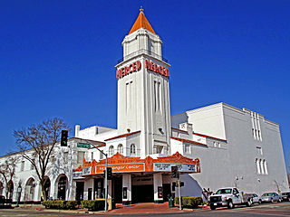
Merced County, is a county located in the northern San Joaquin Valley section of the Central Valley, in the U.S. state of California.

<span class="mw-page-title-main">Warren County, Virginia</span> County in Virginia, United States

Warren County is a U.S. county located in the Commonwealth of Virginia. The 2020 census places Warren County within the Washington-Arlington-Alexandria, DC-VA-MD-WV Metropolitan Statistical Area with a population of 40,727. The county was established in 1836. The county seat is Front Royal.

<span class="mw-page-title-main">Rockingham County, Virginia</span> County in Virginia, United States

Rockingham County is a county located in the U.S. state of Virginia. As of the 2020 census, the population was 83,757. Its county seat is the independent city of Harrisonburg.

<span class="mw-page-title-main">Rockbridge County, Virginia</span> County in Virginia, United States

Rockbridge County is a county in the Shenandoah Valley on the western edge of the Commonwealth of Virginia. As of the 2020 census, the population was 22,650. Its county seat is the city of Lexington. Rockbridge County completely surrounds the independent cities of Buena Vista and Lexington. The Bureau of Economic Analysis combines the independent cities of Buena Vista and Lexington with Rockbridge County for statistical purposes.

<span class="mw-page-title-main">Roanoke County, Virginia</span> County in Virginia, United States

Roanoke County is a county located in the U.S. state of the Commonwealth of Virginia. As of the 2020 census, the population was 96,929. Its county seat is Salem, but the county administrative offices are located in the census-designated place of Cave Spring.

<span class="mw-page-title-main">Pulaski County, Virginia</span> County in Virginia, United States

Pulaski County is a county located in the southwestern part of the U.S. state of Virginia. As of the 2020 census, the population was 33,800. Its county seat is Pulaski. Pulaski County is part of the Blacksburg–Christiansburg, VA Metropolitan Statistical Area.

<span class="mw-page-title-main">Henry County, Virginia</span> County in Virginia, United States

Henry County is a county located in the U.S. state of Virginia. As of the 2020 census, the population was 50,948. The county seat is usually identified as Martinsville; however, the administration building, county courthouse, and Henry County Sheriff's Office are located on Kings Mountain Road in Collinsville.The Henry County Adult Detention Center is located on DuPont Road in Martinsville.

<span class="mw-page-title-main">Giles County, Virginia</span> County in Virginia, United States

Giles County is a county located in the U.S. state of Virginia on the West Virginia state line. As of the 2020 census, the population was 16,787. Its county seat is Pearisburg.

<span class="mw-page-title-main">Essex County, Virginia</span> County in Virginia, United States

Essex County is a county located in the Middle Peninsula in the U.S. state of Virginia; the peninsula is bordered by the Rappahannock River on the north and King and Queen County on the south. As of the 2020 census, the population was 10,599. Its county seat is Tappahannock.

<span class="mw-page-title-main">Clarke County, Virginia</span> County in Virginia, United States

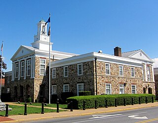
Clarke County is a county in the Commonwealth of Virginia. As of the 2020 census, the population was 14,783. Its county seat is Berryville. Clarke County is included in the Washington-Arlington-Alexandria, DC-VA-MD-WV Metropolitan Statistical Area.

<span class="mw-page-title-main">Botetourt County, Virginia</span> County in Virginia, United States

Botetourt County is a US county that lies in the Roanoke Region of Virginia. Located in the mountainous portion of the state, the county is bordered by two major ranges, the Blue Ridge Mountains and the Appalachian Mountains.

<span class="mw-page-title-main">Augusta County, Virginia</span> County in Virginia, United States

Augusta County is a county in the Shenandoah Valley on the western edge of the Commonwealth of Virginia in the United States. The second-largest county of Virginia by total area, it completely surrounds the independent cities of Staunton and Waynesboro. Its county seat is Staunton, but most of the administrative services have offices in neighboring Verona.

<span class="mw-page-title-main">Alleghany County, Virginia</span> County in Virginia, United States

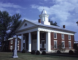
Alleghany County is an American county located on the far western edge of Commonwealth of Virginia. It is bordered by the Allegheny Mountains, from which the county derives its name, and it is the northernmost part of the Roanoke Region. The county seat is Covington. As of the 2020 census, the population was 15,223.

<span class="mw-page-title-main">Lackawanna County, Pennsylvania</span> County in Pennsylvania, United States

Lackawanna County is a county in the Commonwealth of Pennsylvania. It is located in Northeastern Pennsylvania and had a population of 215,615 (2022). Its county seat and most populous city is Scranton. The county is part of the Northeast Pennsylvania region of the state.

<span class="mw-page-title-main">Massanutten, Virginia</span> CDP in Virginia, United States

Massanutten is a census-designated place (CDP) in Rockingham County, Virginia, United States, built around a ski resort. The population was 2,291 at the 2010 census. It is part of the Harrisonburg Metropolitan Statistical Area.

<span class="mw-page-title-main">New Market, Virginia</span> Town in Virginia, United States

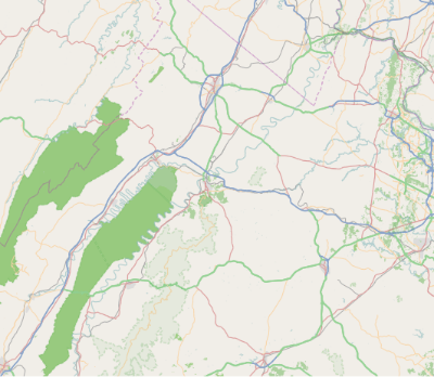
New Market is a town in Shenandoah County, Virginia, United States. Founded as a small crossroads trading town in the Shenandoah Valley, it has a population of 2,155 as of the most recent 2020 U.S. census. The north–south U.S. 11 and the east–west U.S. 211 pass near it and cross Massanutten Mountain at the town's titular gap.

<span class="mw-page-title-main">Strasburg, Virginia</span> Town in Virginia, United States

Strasburg is a town in Shenandoah County, Virginia, United States, which was founded in 1761 by Peter Stover. It is the largest town by population in the county and is known for its grassroots art culture, pottery, antiques, and American Civil War history. The population was 7,083 at the 2020 census.

<span class="mw-page-title-main">Woodstock, Virginia</span> Town in Virginia, United States

Woodstock is a town and the county seat of Shenandoah County, Virginia, United States. It has a population of 5,212 according to the 2017 census. Woodstock comprises 3.2 square miles of incorporated area of the town, and is located along the "Seven Bends" of the North Fork of the Shenandoah River. While some tourism references list Woodstock as the fourth oldest town in Virginia, the area was sparsely settled and perhaps platted in 1752 or shortly thereafter, but the town was actually established by charter in 1761. While there are a number of Virginia towns closer to the eastern seaboard that claim earlier founding dates, Woodstock was one of the first towns west of the Blue Ridge Mountains.

References

  1. "Shenandoah County, Virginia". US Census Bureau. Retrieved January 30, 2022.
  2. "Find a County". National Association of Counties. Retrieved June 7, 2011.
  3. "US Gazetteer files: 2010, 2000, and 1990". US Census Bureau. February 12, 2011. Retrieved April 23, 2011.
  4. "Census of Population and Housing from 1790-2000". US Census Bureau. Retrieved January 24, 2022.
  5. "Historical Census Browser". University of Virginia Library. Retrieved January 5, 2014.
  6. "Population of Counties by Decennial Census: 1900 to 1990". US Census Bureau. Retrieved January 5, 2014.
  7. "Census 2000 PHC-T-4. Ranking Tables for Counties: 1990 and 2000" (PDF). US Census Bureau. Archived (PDF) from the original on March 27, 2010. Retrieved January 5, 2014.
  8. 1 2 "Hispanic or Latino, and Not Hispanic or Latino by Race - 2010: DEC Redistricting Data (PL 94-171) - Shenandoah County VA". US Census Bureau.
  9. 1 2 "Hispanic or Latino, and Not Hispanic or Latino by Race - 2020: DEC Redistricting Data (PL 94-171) - Shenandoah County VA". US Census Bureau.
  10. "American FactFinder"
  11. "2000 Census". US Census Bureau. Retrieved May 14, 2011.
  12. Shenandoah County Sheriff's Office - History Archived July 27, 2009, at the Wayback Machine
  13. Johnson, Colby (June 11, 2022). "Shenandoah County Sheriff's Office loses accreditation". WHSV. Retrieved October 31, 2022.
  14. Humanities, National Endowment for the (November 8, 1901). "Shenandoah Herald. [volume] (Woodstock, Va.) 1865-1974 (Image 2)". ISSN   2333-7788 . Retrieved December 13, 2021.
  15. "Virginia Elections Database » Search Elections". Virginia Elections Database. Retrieved December 13, 2021.
  16. Leip, David. "Atlas of US Presidential Elections". uselectionatlas.org. Retrieved December 8, 2020.

38°52′N78°34′W / 38.86°N 78.57°W / 38.86; -78.57