Southside (Virginia)

Last updated

Southside, or Southside Virginia, has traditionally referred to the portion of the state south of the James River, the geographic feature from which the term derives its name. This was the first area to be developed in the colonial period. [1]

Contents

Southside of Virginia Southside- Location.svg
Southside of Virginia

During the colonial era, Southside was considered the area where entrepreneurs settled, as opposed to some of the more established and wealthier families in the Tidewater counties. Many early Southside settlers were younger sons of established Tidewater families. A major portion of the territory was formed in 1703, when Prince George County, Virginia was organized from Charles City County. Four other counties and three independent cities were formed from this territory, the counties in the 18th century and some of the independent cities in the 19th and 20th centuries.

In the 21st century, however, some people use a more limited definition of the region that is confined to the Piedmont area: those counties lying south of the James River, west of the Fall Line, and east of the Blue Ridge Mountains. This is the southern portion of Virginia's Piedmont region. This definition describes an area often considered to be the heart of Southside. It also accounts for social and economic changes as the eastern counties developed dense populations, and the Richmond suburbs expanded to occupy large portions of Chesterfield and Powhatan counties.

Southside Virginia is also known as Virginia's Black Belt, as it has long had a high concentration of African-Americans relative to other regions of the state. Southside represents the northeastern extremity of the American Black Belt, a heavily African-American region stretching from Virginia to East Texas.

Counties

Counties considered part of the region began those divided from Prince George County: Brunswick, Dinwiddie, Nottoway, Amelia, and Prince Edward, formed from parts of Prince George County. In addition to Richmond, the independent city of Petersburg, Virginia was established in this region.

In addition, the western part of Southside has long been reputed for its isolated, rural, and culturally conservative character. Associated counties are Patrick, Henry, Bedford, Pittsylvania, Halifax, Charlotte, Mecklenburg, Campbell, Lunenburg, Appomattox, Buckingham, Cumberland, Powhatan, and Greensville counties.

The independent cities of Danville, Emporia, and Martinsville are also considered to be in the western part of the region.

The more rural, western areas of Southside are noted for sharing similarities and connections with North Carolina. For instance, residents of Danville and Martinsville frequently visit the Piedmont Triad for amenities and the Piedmont Triad International Airport. Residents of South Boston and Clarksville, Virginia travel to the Research Triangle for amenities, including use of the Raleigh–Durham International Airport.

Climate

Southside Piedmont region has a climate different from the coastal areas of Virginia. Summers are typically hot, with highs generally in the upper 80s to low 90s Fahrenheit or low 30s Celsius; quite often 5 to 7 °F (2.8 to 3.9 °C) hotter than in Richmond. Winters are moderately cold, and nighttime lows often drop below freezing; frequently 5 to 7 °F (2.8 to 3.9 °C) cooler than Norfolk. Much of this has to do with the distance of the region from the temperature-moderating effect of the Atlantic Ocean.

Snow and frozen precipitation (usually less than 1 foot or 0.30 metres) usually falls every year in Southside, with the western and northern fringes of the area getting several inches more snow than the rest.

Industries

Southside, along with much of Upper South, was long known for its tobacco crop. The nutrient-rich soil, along with frequent spring rains, provided ideal growing conditions for tobacco, as well as soybeans and some cold-hardy cotton plants. Tobacco exhausts the soil, however, and in the early 19th century, planters moving into the Piedmont area shifted to mixed crops.

The Fall Line was the area where the first industries were established, with mills running off the water power of rivers, in Richmond and Petersburg, Virginia, for instance. Petersburg was an industrial city with a large proportion of free blacks even before the American Civil War.

Beginning in the 1940s, various textile mills opened up in the Piedmont area of Southside, most notably the enormous Dan River Mills in Danville. Martinsville was also known for its textile mills as well. Companies like Tultex, Pannill Knitting Company, Fieldcrest, and Bassett-Walker. The city as called the " Sweatshirt Capital of the World". The textile industry, formerly located in New England and the Northeast, shifted to the South because of cheaper labor costs and less union organization. The cost of living in much of Southside is still low compared to most metropolitan areas. The Southside workforce found textile work to be much more lucrative than the low incomes associated with farming by that time. Mechanization required larger farms to be profitable.

Along with tobacco manufacturing, textile mills added to the prosperity of the Southside region to become more prosperous. Beginning in the 1970s, however, many of the textile mills closed, outsourcing work to other countries where labor costs were cheaper, such as Mexico, India and other nations in Southeast Asia, and China. The waning demand for tobacco products due to health issues affected the Southside economy.

Furniture manufacturing was another major industry, Kenlea Furniture operated for many years in Kenbridge and the Bassett Furniture company continues to operate in the town of Bassett. The Army bases Fort Gregg-Adams and Fort Barfoot employ many people. They were built up to a large extent during World War II. Some residents commute from this area to the Philip Morris factory in south Richmond.

In the 1990s new manufacturing jobs were established in the area, with manufacturing of industrial-grade metals and ceramics. Numerous prisons were established in the area, and employed local people in relatively high-paying security jobs.

Media

Television stations are receivable from all parts of Southside, with the eastern parts receiving Richmond stations and the western parts receiving Roanoke/Lynchburg stations. In addition, some viewers on the northern edges of the region receive Charlottesville stations, while viewers on the southern edge receive Greensboro/Winston-Salem/High Point and Raleigh/Durham stations.

While most people receive large-market radio stations from the same places as their TV stations, Southside has a large variety of local radio. Country stations tend to dominate Southside radio, though local classic rock, adult contemporary, Top 40, and public radio formats exist.

All of Southside can receive Virginia's largest newspaper, the Richmond Times-Dispatch . Southside is also covered by Cardinal News, a nonprofit newsroom that covers Southwest and Southside Virginia. In addition, all the towns listed below (and others) have local newspapers, and they are generally weekly publications.

Higher education

Colleges in the Southside region include:

Cities and towns

See also

Related Research Articles

<span class="mw-page-title-main">Petersburg, Virginia</span> Independent city in Virginia, United States

Petersburg is an independent city in the Commonwealth of Virginia in the United States. As of the 2020 census, the population was 33,458 with a majority African American. The Bureau of Economic Analysis combines Petersburg with Dinwiddie County for statistical purposes. The city is 21 miles (34 km) south of the commonwealth (state) capital city of Richmond.

<span class="mw-page-title-main">Nottoway County, Virginia</span> County in Virginia, United States

Nottoway County is a county located in the Commonwealth of Virginia. As of the 2020 census, the population was 15,642. Its county seat is Nottoway. It is situated south of the James River, thus making it a part of the Southside Virginia Region.

<span class="mw-page-title-main">Martinsville, Virginia</span> Independent city in Virginia, United States

Martinsville is an independent city in the Commonwealth of Virginia in the United States. As of the 2020 census, the population was 13,485. A community of both Southside and Southwest Virginia, it is the county seat of Henry County, although the two are separate jurisdictions. The Bureau of Economic Analysis combines the city of Martinsville with Henry County for statistical purposes.

<span class="mw-page-title-main">Lynchburg, Virginia</span> Independent city in Virginia, United States

Lynchburg is an independent city in the Commonwealth of Virginia in the United States. First settled in 1757 by ferry owner John Lynch, the city's population was 79,009 at the 2020 census, making Lynchburg the 11th most populous city in Virginia. Located in the foothills of the Blue Ridge Mountains along the banks of the James River, Lynchburg is known as the "City of Seven Hills" or the "Hill City". In the 1860s, Lynchburg was the only city in Virginia that was not recaptured by the Union before the end of the American Civil War.

<span class="mw-page-title-main">Danville, Virginia</span> Independent city in Virginia, United States

Danville is an independent city in the Commonwealth of Virginia in the United States. The city is located in the Southside Virginia region and on the fall line of the Dan River. It was a center of tobacco production and was an area of Confederate activity during the American Civil War, due to its strategic location on the Richmond and Danville Railroad. In April 1865 it briefly served as the final capital of the Confederate States before its surrender later that year.

<span class="mw-page-title-main">James River</span> River in Virginia, United States

The James River is a river in Virginia that begins in the Appalachian Mountains and flows 348 miles (560 km) to the Chesapeake Bay. The river length extends to 444 miles (715 km) if the Jackson River is included, the longer of its two headwaters. It is the longest river in Virginia. Jamestown and Williamsburg, Virginia's first colonial capitals, and Richmond, Virginia's current capital, lie on the James River.

<span class="mw-page-title-main">Greater Richmond Region</span> Metropolitan statistical area in the United States

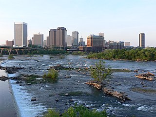
The Greater Richmond Region, the Richmond metropolitan area or Central Virginia, is a region and metropolitan area in the U.S. state of Virginia, centered on Richmond. The U.S. Office of Management and Budget (OMB) defines the area as the Richmond, VA Metropolitan Statistical Area, a Metropolitan Statistical Area (MSA) used by the U.S. Census Bureau and other entities. The OMB defines the area as comprising 17 county-level jurisdictions, including the independent cities of Richmond, Petersburg, Hopewell, and Colonial Heights. As of 2020, it had a population of 1,314,434, making it the 44th largest MSA in the country.

<span class="mw-page-title-main">Midlothian, Virginia</span> Unincorporated community in Virginia, United States

Midlothian is an unincorporated area and Census-designated place in Chesterfield County, Virginia, U.S. Settled as a coal town, Midlothian village experienced suburbanization effects and is now part of the western suburbs of Richmond, Virginia south of the James River in the Greater Richmond Region. Because of its unincorporated status, Midlothian has no formal government, and the name is used to represent the original small Village of Midlothian and a vast expanse of Chesterfield County in the northwest portion of Southside Richmond served by the Midlothian post office.

<span class="mw-page-title-main">Southside Railroad (Virginia)</span>

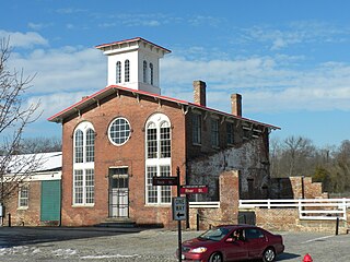
The Southside Railroad was formed in Virginia in 1846. Construction was begun in 1849 and completed in 1854. The 5 ft gauge railroad connected City Point, a port on the James River with the farm country south and west of Petersburg, Virginia, to Lynchburg, Virginia, a distance of about 132 miles (212 km).

<span class="mw-page-title-main">Southside (Richmond, Virginia)</span> Neighborhood of Richmond, Virginia, United States

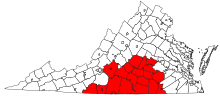
The Southside of Richmond is an area of the Metropolitan Statistical Area surrounding Richmond, Virginia. It generally includes all portions of the City of Richmond that lie south of the James River, and includes all of the former city of Manchester. Depending on context, the term "Southside of Richmond" can include some northern areas of adjacent Chesterfield County, Virginia in the Richmond-Petersburg region. With minor exceptions near Bon Air, VA, the Chippenham Parkway forms the border between Chesterfield County and the City of Richmond portions of Southside, with some news agencies using the term "South Richmond" to refer to the locations in Southside located in the city proper.

<span class="mw-page-title-main">Transportation in Virginia</span> Overview of land sea and air transport systems in Virginia

Transportation in the Commonwealth of Virginia is by land, sea and air. Virginia's extensive network of highways and railroads were developed and built over a period almost 400 years, beginning almost immediately after the founding of Jamestown in 1607, and often incorporating old established trails of the Native Americans.

<span class="mw-page-title-main">Area code 434</span> Area code for southern Virginia, United States

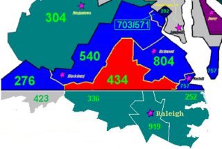
Area code 434 is a telephone area code in the North American Numbering Plan (NANP) for the south-central area of the Commonwealth of Virginia. Lynchburg is the most populous city in the numbering plan area.

<span class="mw-page-title-main">Tri-Cities, Virginia</span>

The Tri-Cities of Virginia is an area in the Greater Richmond Region which includes the three independent cities of Petersburg, Colonial Heights, and Hopewell and portions of the adjoining counties of Chesterfield, Dinwiddie, and Prince George in south-central Virginia. Other unincorporated communities located in the Tri-Cities area include Ettrick, Fort Lee, and City Point, the latter formerly a historic incorporated town which was annexed to become part of the City of Hopewell.

The AA Piedmont District is a high school conference of the Virginia High School League that includes schools from Southwest and Southside Virginia, mostly in the Martinsville and the Danville areas. The schools of the Piedmont District compete in AA Region IV with the schools in the AA River Ridge District and the AA Southwest District. Until the 1990s, the AA Piedmont District was a member of AA Region III but was moved to balance the number of schools in the VHSL's AA regions. Due to declining school enrollment, Dan River High School became a member of the A Dogwood District beginning in the 2007–08 school year.

eCorridors is an information technology program to promote and facilitate broadband access for communities of Virginia and nearby areas. It was developed by faculty at the Virginia Polytechnic Institute and State University (VT) in the spring of 2000.

<span class="mw-page-title-main">Interstate 85 in Virginia</span> Section of Interstate Highway in Virginia, United States

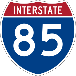
Interstate 85 (I-85) is a part of the Interstate Highway System that runs from Montgomery, Alabama, to Petersburg, Virginia. In Virginia, the Interstate Highway runs 68.64 miles (110.47 km) from the North Carolina state line near Bracey north to I-95 in Petersburg. I-85 passes through the eastern part of Southside, where it parallels US Route 1 (US 1) from Petersburg, where the highway runs concurrently with US 460, to south of South Hill, where the highway intersects Southside's major east–west highway, US 58. The Interstate Highway is the primary connection between the Greater Richmond Region and Research Triangle and other major metropolitan areas of North Carolina. Like all mainline Interstate Highways, I-85 is a part of the National Highway System for its entire length in Virginia.

<span class="mw-page-title-main">Blue Ridge Mountains Council</span>

The Blue Ridge Mountains Council is a Boy Scouts of America council located in Roanoke, Virginia, that serves Scouts in southwest and south central Virginia. The Blue Ridge Mountains Council owns and operates the Blue Ridge Scout Reservation in Pulaski County, Virginia, the largest Council-owned Scout reservation in the United States. The council's Tutelo Lodge is part of the Order of the Arrow.

The following is a timeline of the history of the city of Richmond, Virginia, United States

References

  1. Melton, Herman (2006). Southside Virginia: Echoing Through History. The History Press. pp. 11–12. ISBN   1-59629-137-0.