Blue Ridge Mountains

Last updated

Blue Ridge Mountains
Rainy Blue Ridge-27527.jpg
The Blue Ridge Mountains as seen from the Blue Ridge Parkway near Mount Mitchell in North Carolina
Highest point
Peak Mount Mitchell
Elevation 6,684 ft (2,037 m)
Coordinates 35°45′53″N82°15′55″W / 35.76472°N 82.26528°W / 35.76472; -82.26528
Geography
Blue Ridge Province.jpg
CountryUnited States
States North Carolina, Virginia, Tennessee, Maryland, Pennsylvania, West Virginia, South Carolina, Georgia and Alabama
Parent range Appalachian Mountains
Geology
Orogeny Grenville orogeny
Type of rock granite, gneiss and limestone

The Blue Ridge Mountains are a physiographic province of the larger Appalachian Highlands range. The mountain range is located in the Eastern United States and extends 550 miles southwest from southern Pennsylvania through Maryland, West Virginia, Virginia, North Carolina, South Carolina, Tennessee, and Georgia. [1] The province consists of northern and southern physiographic regions, which divide near the Roanoke River gap. [2] To the west of the Blue Ridge, between it and the bulk of the Appalachians, lies the Great Appalachian Valley, bordered on the west by the Ridge and Valley province of the Appalachian range.

Contents

The Blue Ridge Mountains are known for having a bluish color when seen from a distance. Trees put the "blue" in Blue Ridge, from the isoprene released into the atmosphere. [3] This contributes to the characteristic haze on the mountains and their perceived color. [4]

Within the Blue Ridge province are two major national parks: the Shenandoah National Park in the northern section and the Great Smoky Mountains National Park in the southern section. The Blue Ridge Parkway, a 469-mile (755 km) long scenic highway, connects the two parks and runs along the ridge crest-lines, as does the Appalachian Trail. [5] Eight national forests include George Washington and Jefferson, Cherokee, Pisgah, Nantahala and Chattahoochee.

Geography

Blue Ridge Mountains - Front Royal, Virginia Blue Ridge Mountains - Front Royal, Virginia.jpg
Blue Ridge Mountains - Front Royal, Virginia

Although the term "Blue Ridge" is sometimes applied exclusively to the eastern edge or front range of the Appalachian Mountains, the geological definition of the Blue Ridge province extends westward to the Ridge and Valley area, encompassing the Great Smoky Mountains, the Great Balsams, the Roans, the Blacks, and other mountain ranges. To the east, two lower elevation ranges referred to as foothills are also often included as "spurs" of the Blue Ridge: the Brushy Mountains and the South Mountains.

The Blue Ridge Mountains as seen from Blowing Rock, North Carolina Blowing Rock.jpg
The Blue Ridge Mountains as seen from Blowing Rock, North Carolina
The Blue Ridge near Massies Mill, Nelson County, Virginia Blue Ridge Nelson Co VA.jpg
The Blue Ridge near Massies Mill, Nelson County, Virginia

The Blue Ridge extends as far south as Mount Oglethorpe in Georgia and as far north into Pennsylvania as South Mountain. While South Mountain dwindles to hills between Gettysburg and Harrisburg, the band of ancient rocks that form the core of the Blue Ridge continues northeast through the New Jersey and Hudson River highlands, eventually reaching the Berkshires of Massachusetts and the Green Mountains of Vermont.

The Blue Ridge contains the highest mountains in eastern North America south of Baffin Island. About 125 peaks exceed 5,000 feet (1,500 m) in elevation. [6] The highest peak in the Blue Ridge (and in the entire Appalachian chain) is Mount Mitchell in North Carolina at 6,684 feet (2,037 m). There are 39 peaks in North Carolina and Tennessee higher than 6,000 feet (1,800 m); by comparison, in the northern portion of the Appalachian chain only New Hampshire's Mount Washington rises above 6,000 feet (1,800 m). Southern Sixers is a term used by peak baggers for this group of mountains. [7]

The Blue Ridge Parkway runs 469 miles (755 km) along crests of the southern Appalachians and links two national parks: Shenandoah and Great Smoky Mountains. In many places along the parkway, there are metamorphic rocks (gneiss) with folded bands of light-and dark-colored minerals, which sometimes look like the folds and swirls in a marble cake.

Geology

Blue Ridge Mountains, viewed from Chimney Rock Mountain Overlook in North Carolina Chimney Rock Mountain Overlook.jpg
Blue Ridge Mountains, viewed from Chimney Rock Mountain Overlook in North Carolina

Most of the rocks that form the Blue Ridge Mountains are ancient granitic charnockites, metamorphosed volcanic formations, and sedimentary limestone. Recent studies completed by Richard Tollo, a professor and geologist at George Washington University, provide greater insight into the petrologic and geochronologic history of the Blue Ridge basement suites. Modern studies have found that the basement geology of the Blue Ridge is made of compositionally unique gneisses and granitoids, including orthopyroxene-bearing charnockites. Analysis of zircon minerals in the granite completed by John Aleinikoff at the U.S. Geological Survey has provided more detailed emplacement ages.

The northernmost extension of the Blue Ridge Mountains, in northern Maryland South Mountain-airphoto.jpg
The northernmost extension of the Blue Ridge Mountains, in northern Maryland

Many of the features found in the Blue Ridge and documented by Tollo and others have confirmed that the rocks exhibit many similar features in other North American Grenville-age terranes. The lack of a calc-alkaline affinity and zircon ages less than 1.2 billion years old suggest that the Blue Ridge is distinct from the Adirondacks, Green Mountains, and possibly the New York–New Jersey Highlands. The petrologic and geochronologic data suggest that the Blue Ridge basement is a composite orogenic crust that was emplaced during several episodes from a crustal magma source. Field relationships further illustrate that rocks emplaced prior to 1.078–1.064 billion years ago preserve deformational features. Those emplaced post-1.064 billion years ago generally have a massive texture and missed the main episode of Mesoproterozoic compression. [8]


At the time of their emergence, the Blue Ridge were among the highest mountains in the world and reached heights comparable to the much younger Alps. Weathering, erosion, and mass wasting over hundreds of millions of years has resulted in much shorter peaks. [9]

History

The Blue Ridge Mountains, looking especially blue in the background, seen from Lynchburg, Virginia Blue Ridge Mountains from Liberty University in Lynchburg, VA IMG 4115.JPG
The Blue Ridge Mountains, looking especially blue in the background, seen from Lynchburg, Virginia

At the foot of the Blue Ridge, various tribes including the Siouan Manahoacs, the Iroquois, and the Shawnee hunted and fished. A German physician-explorer, John Lederer, first reached the crest of the Blue Ridge in 1669 and again the following year; he also recorded the Virginia Siouan name for the Blue Ridge (Ahkonshuck).

At the Treaty of Albany negotiated by Virginia Lieutenant Governor Alexander Spotswood with the Iroquois between 1718 and 1722, the Iroquois ceded lands they had conquered south of the Potomac River and east of the Blue Ridge to the Virginia Colony. This treaty made the Blue Ridge the new demarcation point between the areas and tribes subject to the Six Nations, and those tributaries to the colony. When colonists began to disregard this by crossing the Blue Ridge and settling in the Shenandoah Valley in the 1730s, the Iroquois began to object, finally selling their rights to the valley, on the west side of the Blue Ridge, at the Treaty of Lancaster in 1744.

Flora and fauna

View of Blue Ridge Mountains from Grandfather Mountain in North Carolina Blue Ridge Parkway by Grandfather Mountain NC.jpg
View of Blue Ridge Mountains from Grandfather Mountain in North Carolina

Flora

The Blue Ridge Mountains have stunted oak and oak-hickory forest habitats, which comprise most of the Appalachian slope forests. Flora also includes grass, shrubs, hemlock and mixed-oak pine forests. [10]

While the Blue Ridge range includes the highest summits in the eastern United States, the climate is nevertheless too warm to support an alpine zone, and thus the range lacks the tree line found at lower elevations in the northern half of the Appalachian range. Statistical modelling predicts that the alpine tree line would exist at above 7,985 feet (2434 m) in the climate zone and latitude of the southern Appalachians. [11] The highest parts of the Blue Ridge are generally vegetated in dense Southern Appalachian spruce-fir forests.[ citation needed ]

Fauna

The area is host to many animals, including:

Population centers

The largest city located in the Blue Ridge Mountains is Roanoke, located in Southwest Virginia, while the largest Metropolitan Statistical Area is the Greenville metropolitan area in Upstate, South Carolina. [12] Other notable cities in the Blue Ridge Mountains include Charlottesville, Frederick, Hagerstown, Chambersburg, Asheville, Johnson City, and Lynchburg.

See also

Related Research Articles

<span class="mw-page-title-main">Appalachian Mountains</span> Mountain range in eastern North America

The Appalachian Mountains, often called the Appalachians, are a mountain range in eastern to northeastern North America. Here, the term "Appalachian" refers to several different regions associated with the mountain range, and its surrounding terrain. The general definition used is one followed by the United States Geological Survey and the Geological Survey of Canada to describe the respective countries' physiographic regions. The U.S. uses the term Appalachian Highlands and Canada uses the term Appalachian Uplands; the Appalachian Mountains are not synonymous with the Appalachian Plateau, which is one of the provinces of the Appalachian Highlands.

<span class="mw-page-title-main">Shenandoah Valley</span> Region of Virginia and West Virginia

The Shenandoah Valley is a geographic valley and cultural region of western Virginia and the Eastern Panhandle of West Virginia in the United States. The Valley is bounded to the east by the Blue Ridge Mountains, to the west by the eastern front of the Ridge-and-Valley Appalachians, to the north by the Potomac River, to the south by the James River, and to the Southwest by the New River Valley. The cultural region covers a larger area that includes all of the Valley plus the Virginia Highlands to the west and the Roanoke Valley to the south. It is physiographically located within the Ridge and Valley Province and is a portion of the Great Appalachian Valley.

<span class="mw-page-title-main">Great Appalachian Valley</span> Major landform in eastern North America

The Great Appalachian Valley, also called The Great Valley or Great Valley Region, is one of the major landform features of eastern North America. It is a gigantic trough, including a chain of valley lowlands, and the central feature of the Appalachian Mountains system. The trough stretches about 1,200 miles (1,900 km) from Quebec in the north to Alabama in the south and has been an important north–south route of travel since prehistoric times.

<span class="mw-page-title-main">Blue Ridge Parkway</span> Scenic parkway in the United States

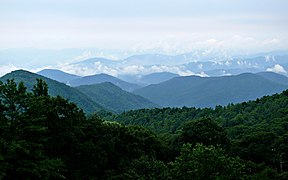
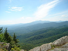
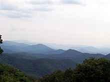
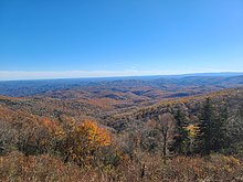
The Blue Ridge Parkway is a National Parkway and All-American Road in the United States, noted for its scenic beauty. The parkway, which is the longest linear park in the U.S., runs for 469 miles (755 km) through 29 counties in Virginia and North Carolina, linking Shenandoah National Park to Great Smoky Mountains National Park. It runs mostly along the spine of the Blue Ridge, a major mountain chain that is part of the Appalachian Mountains. Its southern terminus is at U.S. Route 441 (US 441) on the boundary between Great Smoky Mountains National Park and the Qualla Boundary of the Eastern Band of Cherokee Indians in North Carolina, from which it travels north to Shenandoah National Park in Virginia. The roadway continues through Shenandoah as Skyline Drive, a similar scenic road which is managed by a different National Park Service unit. Both Skyline Drive and the Virginia portion of the Blue Ridge Parkway are part of Virginia State Route 48 (SR 48), though this designation is not signed.

<span class="mw-page-title-main">Geography of North Carolina</span> Geography of the US state of North Carolina

The geography of North Carolina falls naturally into three divisions — the Appalachian Mountains in the west, the central Piedmont Plateau, and the eastern Atlantic Coastal Plain. North Carolina covers 53,819 square miles (139,391 km2) and is 503 miles (810 km) wide by 150 miles (241 km) long. The physical characteristics of the state vary from the summits of the Smoky Mountains, an altitude of near seven thousand feet (2,130 m) in the west, sloping eastward to sea level along the coast and beaches of the Atlantic Ocean.

<span class="mw-page-title-main">Ridge-and-Valley Appalachians</span> Physiographic province of the larger Appalachian division

The Ridge-and-Valley Appalachians, also called the Ridge and Valley Province or the Valley and Ridge Appalachians, are a physiographic province of the larger Appalachian Highlands division. The physiographic province is divided into three sections: the Hudson Valley, the Central, and the Tennessee.

<span class="mw-page-title-main">Clingmans Dome</span> Mountain, highest peak in Tennessee, United States

Clingmans Dome is a mountain in the Great Smoky Mountains of Tennessee and North Carolina in the Southeastern United States. Its name in Cherokee is Kuwahi or Kuwohi, meaning "mulberry place."

<span class="mw-page-title-main">Alleghanian orogeny</span> Mountain-forming event that formed the Appalachian and Allegheny Mountains

The Alleghanian orogeny or Appalachian orogeny is one of the geological mountain-forming events that formed the Appalachian Mountains and Allegheny Mountains. The term and spelling Alleghany orogeny was originally proposed by H.P. Woodward in 1957.

<span class="mw-page-title-main">Shenandoah Mountain</span>

Shenandoah Mountain is a mountain ridge approximately 73 miles (117 km) long in Virginia and West Virginia. The steep, narrow, sandstone-capped ridge extends from northern Bath County, Virginia to southern Hardy County, West Virginia. Along the way, its crest defines the borders between Highland and Augusta counties, Virginia, and between Pendleton County, West Virginia, and Rockingham County, Virginia. Its high point is 4397’/1340 m Reddish Knob along the Virginia/West Virginia border.

<span class="mw-page-title-main">Massanutten Mountain</span> Ridge in the Appalachians in Virginia, United States

Massanutten Mountain is a synclinal ridge in the Ridge-and-Valley Appalachians, located in the U.S. state of Virginia. It is near the West Virginia state line.

<span class="mw-page-title-main">Grenville orogeny</span> Mesoproterozoic mountain-building event

The Grenville orogeny was a long-lived Mesoproterozoic mountain-building event associated with the assembly of the supercontinent Rodinia. Its record is a prominent orogenic belt which spans a significant portion of the North American continent, from Labrador to Mexico, as well as to Scotland.

<span class="mw-page-title-main">Rockfish Gap</span>

Rockfish Gap is a wind gap located in the Blue Ridge Mountains between Charlottesville and Waynesboro, Virginia, United States, through Afton Mountain, which is frequently used to refer to the gap.

The Appalachian National Scenic Trail spans 14 U.S. states over its roughly 2,200 miles (3,500 km): Georgia, North Carolina, Tennessee, Virginia, West Virginia, Maryland, Pennsylvania, New Jersey, New York, Connecticut, Massachusetts, Vermont, New Hampshire, and Maine. The southern end is at Springer Mountain, Georgia, and it follows the ridgeline of the Appalachian Mountains, crossing many of its highest peaks and running almost continuously through wilderness before reaching the northern end at Mount Katahdin, Maine.

<span class="mw-page-title-main">Geology of Georgia (U.S. state)</span> Overview of the geology of the U.S. state of Georgia

The U.S. state of Georgia is commonly divided into four geologic regions that influence the location of the state's four traditional physiographic regions. The four geologic regions include the Appalachian foreland, Blue Ridge, Piedmont, and Coastal Plain. These four geologic regions commonly share names with and typically overlap the four physiographic regions of the state: the Appalachian Plateau and adjacent Valley and Ridge; the Blue Ridge; the Piedmont and the Coastal Plain.

<span class="mw-page-title-main">Appalachian Highlands</span> Physiographic division of the United States

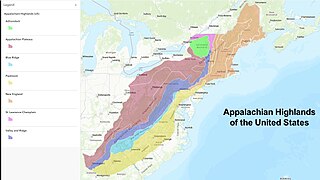
The Appalachian Highlands is one of eight government-defined physiographic divisions of the contiguous United States. The links with the Appalachian Uplands in Canada to make up the Appalachian Mountains. The Highlands includes seven physiographic provinces, which is the second level in the physiographic classification system in the United States. At the next level of physiographic classification, called section/subsection, there are 20 unique land areas with one of the provinces having no sections.

<span class="mw-page-title-main">Southern Appalachian spruce–fir forest</span> Ecoregion of the southern Appalachian Mountains of the eastern United States

The southern Appalachian spruce–fir forest is an ecoregion of the temperate coniferous forests biome, a type of montane coniferous forest that grows in the highest elevations in the southern Appalachian Mountains of the eastern United States. The ecoregion is the highest and coldest forest type in the Appalachian range, thriving in elevations above 5,500 feet (1,700 m) where the climate is too harsh to support the broad-leaved hardwood forest that dominates the region's lower elevations. A relict of the last Ice Age, this forest type covers just over 100 square miles (260 km2) and is considered the second-most endangered ecosystem in the United States.

Humpback Rocks is a massive greenstone outcropping near the peak of Humpback Mountain in the Blue Ridge Mountains of Augusta County and Nelson County, Virginia, United States, with a summit elevation of 3,080 feet (940 m). The rock formation is so named for the visual effect of a "hump" it creates on the western face of the mountain.

<span class="mw-page-title-main">Environment of Virginia</span>

The natural environment of Virginia encompasses the physical geography and biology of the U.S. state of Virginia. Virginia has a total area of 42,774.2 square miles (110,784.67 km2), including 3,180.13 square miles (8,236.5 km2) of water, making it the 35th-largest state by area. Forests cover 65% of the state, wetlands and water cover 6% of the land in the state, while 5% of the state is a mixture of commercial, residential, and transitional.

The Glenwood Cluster is a region in the George Washington and Jefferson National Forests recognized by The Wilderness Society for its rich biodiversity, scenery, wildflower displays, cold-water trout streams and horse trails. It offers a unique habitat for rare plants, salamanders and other rare species. The Blue Ridge Parkway and the Appalachian Trail traverse the area, giving ready access with views to the east of the Piedmont region and to the west of the Valley of Virginia.

References

  1. "Blue Ridge". U.S. Geological Survey. Archived from the original on December 24, 2019. Retrieved December 19, 2018.
  2. "Physiographic divisions of the conterminous U. S." U.S. Geological Survey. Archived from the original on December 5, 2007. Retrieved December 6, 2007.
  3. Johnson, A. W. (1998). Invitation To Organic Chemistry . Jones & Bartlett Learning. p.  261. ISBN   978-0-7637-0432-2. blue mountains chemical terpene.
  4. "Blue Ridge Parkway, Frequently Asked Questions". National Park Service. 2007. Archived from the original on December 28, 2007. Retrieved December 29, 2007.
  5. Leighty, Dr. Robert D. (2001). "Blue Ridge Physiographic Province". Contract Report. Defense Advanced Research Projects Agency (DOD) Information Sciences Office. Archived from the original on May 21, 2008. Retrieved December 29, 2007.
  6. Medina, M.A.; J.C. Reid; R.H. Carpenter (2004). "Physiography of North Carolina" (PDF). North Carolina Geological Survey, Division of Land Resources. Archived (PDF) from the original on December 16, 2007. Retrieved December 29, 2007.
  7. "South Beyond 6000". Archived from the original on March 3, 2016. Retrieved September 19, 2016.
  8. Tollo, Richard P.; Aleinkoff, John N.; Borduas, Elizabeth A. (2004). "Petrology and Geochronology of Grenville-Age Magmatism, Blue Ridge Province, Northern Virginia". Northeastern Section (39th Annual) and Southeastern Section (53rd Annual) Joint Meeting. Geological Society of America. Archived from the original on October 22, 2007. Retrieved November 9, 2006.
  9. Davis, Donald E.; Colten, Craig E.; Nelson, Megan Kate; Saikku, Mikko; Allen, Barbara L. (2006). Southern United States: An Environmental History. ABC-CLIO. p. 261. ISBN   9781851097807. Archived from the original on November 25, 2020. Retrieved April 22, 2019.
  10. "Blue Ridge Mountains". The New Georgia Encyclopedia. Archived from the original on June 17, 2010. Retrieved September 4, 2016.
  11. Cogbill, Charles V.; White, Peter S.; Wiser, Susan K. (1997). "Predicting Treeline Elevation in the Southern Appalachians". Castanea. 62 (3): 137–146. JSTOR   4033963.
  12. "2020 State-based Metropolitan and Micropolitan Statistical Areas Maps".

Further reading