Fulton County, Pennsylvania

Last updated

Fulton County
Courthouse-600px.jpg
The Fulton County Courthouse
County Seal 600 dpi transparent shadow 2.png
Map of Pennsylvania highlighting Fulton County.svg
Location within the U.S. state of Pennsylvania
Pennsylvania in United States.svg
Pennsylvania's location within the U.S.
Coordinates: 39°55′N78°07′W / 39.92°N 78.11°W / 39.92; -78.11
CountryFlag of the United States.svg United States
StateFlag of Pennsylvania.svg  Pennsylvania
FoundedApril 19, 1850
Named for Robert Fulton
Seat McConnellsburg
Largest boroughMcConnellsburg
Area
  Total438 sq mi (1,130 km2)
  Land438 sq mi (1,130 km2)
  Water0.5 sq mi (1 km2)  0.1%
Population
 (2020)
  Total14,556
  Density33/sq mi (13/km2)
Time zone UTC−5 (Eastern)
  Summer (DST) UTC−4 (EDT)
Congressional district 13th
Website www.co.fulton.pa.us

Fulton County is a county in the Commonwealth of Pennsylvania. As of the 2020 census, the population was 14,556, [1] making it the fourth-least populous county in Pennsylvania. Its county seat is McConnellsburg. [2] The county was created on April 19, 1850, [3] from a part of Bedford County and named after inventor Robert Fulton. [4] The county is part of the Southwest Pennsylvania region of the state. [lower-alpha 1]

Contents

Geography

According to the U.S. Census Bureau, the county has a total area of 438 square miles (1,130 km2), of which 438 square miles (1,130 km2) is land and 0.5 square miles (1.3 km2) (0.1%) is water. [5] It is in the watershed of the Chesapeake Bay and, although most of the county is drained by the Potomac River, some northern and northeastern areas are drained by the Juniata River into the Susquehanna River. It has a humid continental climate (Dfa/Dfb) and average monthly temperatures in McConnellsburg range from 29.2 °F in January to 73.0 °F in July. [6]

Adjacent counties

Geology

Fulton County is situated within the Ridge and Valley physiographic province, which is characterized by folded and faulted sedimentary rocks of early to middle Paleozoic age. [7]

The stratigraphic record of sedimentary rocks within the county spans from the Cambrian Shadygrove Formation outcropping just south of McConnelsburg to the Pennsylvanian Allegheny Group at the northernmost tip of the county. No igneous or metamorphic rocks of any kind exist within Fulton county.

Mountain ridges within Fulton County include Rays Hill (along the western border with Bedford County), Town Hill, Sideling Hill, Scrub Ridge, and Meadow Grounds Mountain, and all these are held up by the Mississippian Pocono Formation, made of quartz sandstone and conglomerate. Rays Hill and Town Hill form a syncline, as do Scrub Ridge and Meadow Grounds Mountain, and Sideling Hill itself is a syncline. Dickeys Mountain and Tuscarora Mountain (along the eastern border with Franklin County) also form a syncline, but these ridges are held up by the Tuscarora Formation. Broad Top, located in the northeast corner of the county, is a plateau of relatively flat-lying rocks that are stratigraphically higher, and thus younger (Mississippian and Pennsylvanian), than most of the other rocks within the county. Broad Top extends into Huntingdon County to the north and Bedford County to the west.

All of Fulton County lies far to the south of the terminal moraine, and thus it was never glaciated. [8] However, during the Pleistocene epoch, or "Ice Age," periglacial (meaning "around glacier" or simply "cold") processes dominated. Most of the county was most likely a tundra during the Pleistocene.

The Broad Top Coal Field is located in Wells Township in the northwestern corner of the county. [9] The field contains bituminous coal. There are a few abandoned mines in the area, although acid mine drainage is not as much of an environmental problem in Fulton County as it is in adjacent Bedford and Huntingdon Counties.

Interesting geologic features within Fulton County include some of the following:

Demographics

Historical population
CensusPop.Note
1850 7,567
1860 9,13120.7%
1870 9,3602.5%
1880 10,1498.4%
1890 10,137−0.1%
1900 9,924−2.1%
1910 9,703−2.2%
1920 9,617−0.9%
1930 9,231−4.0%
1940 10,67315.6%
1950 10,387−2.7%
1960 10,5972.0%
1970 10,7761.7%
1980 12,84219.2%
1990 13,8377.7%
2000 14,2613.1%
2010 14,8454.1%
2020 14,556−1.9%
[10]

As of the census [11] of 2000, there were 14,261 people, 5,660 households, and 4,097 families residing in the county. The population density was 33 people per square mile (13 people/km2). There were 6,790 housing units at an average density of 16 units per square mile (6.2/km2). The racial makeup of the county was 98.25% White, 0.66% Black or African American, 0.20% Native American, 0.11% Asian, 0.01% Pacific Islander, 0.04% from other races, and 0.72% from two or more races. 0.36% of the population were Hispanic or Latino of any race. 40.8% were of German, 20.4% American, 8.3% Irish and 6.9% English ancestry.

There were 5,660 households, out of which 31.70% had children under the age of 18 living with them, 59.50% were married couples living together, 8.20% had a female householder with no husband present, and 27.60% were non-families. 24.00% of all households were made up of individuals, and 10.60% had someone living alone who was 65 years of age or older. The average household size was 2.50 and the average family size was 2.95.

In the county, the population was spread out, with 24.60% under the age of 18, 7.60% from 18 to 24, 28.40% from 25 to 44, 25.00% from 45 to 64, and 14.50% who were 65 years of age or older. The median age was 38 years. For every 100 females there were 100.10 males. For every 100 females age 18 and over, there were 98.60 males.

Almost everyone who lives in Fulton County speaks English as their first language. The dominant form of speech in Fulton County is the Central Pennsylvania accent.

2020 census

Fulton County Racial Composition [12]
RaceNum.Perc.
White (NH)13,72694.3%
Black or African American (NH)1240.85%
Native American (NH)250.17%
Asian (NH)410.3%
Pacific Islander (NH)30.02%
Other/Mixed (NH)4913.4%
Hispanic or Latino 1461%

Politics

United States presidential election results for Fulton County, Pennsylvania [13]
Year Republican Democratic Third party
No.%No.%No.%
2020 6,82485.41%1,08513.58%811.01%
2016 5,69483.47%91213.37%2163.17%
2012 4,81477.38%1,31021.06%971.56%
2008 4,64273.61%1,57624.99%881.40%
2004 4,77276.10%1,47523.52%240.38%
2000 3,75371.01%1,42526.96%1072.02%
1996 2,66554.75%1,62033.28%58311.98%
1992 2,55850.93%1,58831.61%87717.46%
1988 3,08666.42%1,53232.97%280.60%
1984 3,25471.14%1,30928.62%110.24%
1980 2,74064.90%1,34231.79%1403.32%
1976 2,21954.76%1,73742.87%962.37%
1972 2,51566.24%1,19231.39%902.37%
1968 2,20055.37%1,17429.55%59915.08%
1964 1,74744.37%2,18055.37%100.25%
1960 2,69861.61%1,67238.18%90.21%
1956 2,37056.50%1,81943.36%60.14%
1952 2,12755.12%1,71844.52%140.36%
1948 1,76050.65%1,68448.46%310.89%
1944 2,08454.03%1,75845.58%150.39%
1940 2,10851.46%1,98248.39%60.15%
1936 2,08546.02%2,43153.65%150.33%
1932 1,41041.83%1,92156.99%401.19%
1928 2,17966.82%1,05432.32%280.86%
1924 1,16047.64%1,20749.57%682.79%
1920 1,29250.19%1,23147.82%511.98%
1916 80239.62%1,19959.24%231.14%
1912 31715.34%1,08052.25%67032.41%
1908 97445.45%1,09851.24%713.31%
1904 1,10048.48%1,13750.11%321.41%
1900 1,03945.27%1,22453.33%321.39%
1896 1,08345.83%1,24652.73%341.44%
1892 91842.74%1,21056.33%200.93%
1888 95142.93%1,23055.53%341.53%

Although Fulton County traditionally voted Democratic in the 19th and early 20th centuries, and Democrats held the edge in voter registration in the county until between 1984 and 1998, it has displayed strong tendencies to vote for Republican candidates since the New Deal era. In the 2004 United States presidential election, George W. Bush carried the county by a massive 52.6% margin over John Kerry, making it Bush's strongest county in the slightly Democratic state, which Kerry won by a 2.5% margin over Bush. In 2008, John McCain carried Fulton by a 48.6% margin over Barack Obama, McCain's best showing in Pennsylvania, which Obama won by a 10.3% margin over McCain. [13] The county voted for Donald Trump in 2016 by a 70.8% margin, the highest in the state. The county has voted for the Republican in every presidential election since 1964. In 2006, Rick Santorum and Lynn Swann received more than 60% of the Fulton County vote despite their defeats statewide. In the 2012 election, Fulton County was the only county in Pennsylvania where Barack Obama won less than 25% of the white vote. [14]

Voter registration

As of February 5, 2024, there are 9,319 registered voters in the county. There are 6,851 registered Republicans, 1,523 registered Democrats, 674 voters registered non-affiliated voters, and 271 voters registered to other parties. [15]

Chart of Voter Registration

   Republican (73.52%)
   Democratic (16.34%)
   Independent (7.23%)
   Other Parties (2.91%)

Law and government

State Senate

State House of Representatives

United States House of Representatives

United States Senate

Education

Map of Fulton County, Pennsylvania Public School Districts Map of Fulton County Pennsylvania School Districts.png
Map of Fulton County, Pennsylvania Public School Districts

Public school districts

Transportation

Major highways

Other

Fulton County is one of only two counties in Pennsylvania with no known active railroad lines of any kind, the other being Sullivan County. [17]

Communities

Map of Fulton County, Pennsylvania with Municipal Labels showing Boroughs (red) and Townships (white). Map of Fulton County Pennsylvania With Municipal and Township Labels.png
Map of Fulton County, Pennsylvania with Municipal Labels showing Boroughs (red) and Townships (white).

Under Pennsylvania law, there are four types of incorporated municipalities: cities, boroughs, townships, and, in at most two cases, towns. The following boroughs and townships are located in Fulton County:

Boroughs

Townships

Unincorporated communities

Population ranking

The population ranking of the following table is based on the 2010 census of Fulton County. [18]

county seat

RankCity/Town/etc.Municipal typePopulation (2010 Census)
1 Belfast Township1,448
2 McConnellsburg Borough1,220
3 Needmore CDP170
4 Valley-Hi Borough15

Census-designated places

See also

Related Research Articles

<span class="mw-page-title-main">Bedford County, Pennsylvania</span> County in Pennsylvania, United States

Bedford County is a county in the Commonwealth of Pennsylvania. As of the 2020 census, the population was 47,577. The county seat is Bedford. The county is part of the Southwest Pennsylvania region of the state.

<span class="mw-page-title-main">Sullivan County, Pennsylvania</span> County in Pennsylvania, United States

Sullivan County is a county in the Commonwealth of Pennsylvania. As of the 2020 census, the population was 5,840, making it the second-least populous county in Pennsylvania. Its county seat is Laporte. The county was created on March 15, 1847, from part of Lycoming County and named for Major General John Sullivan. The county is part of the Northeast Pennsylvania region of the state.

<span class="mw-page-title-main">Somerset County, Pennsylvania</span> County in Pennsylvania, United States

Somerset County is a county in the Commonwealth of Pennsylvania. As of the 2020 census, the population was 74,129. Its county seat is Somerset. The county was created from part of Bedford County on April 17, 1795, and named after the county of Somerset in England. The county is part of the Southwest Pennsylvania region of the state.

<span class="mw-page-title-main">Huntingdon County, Pennsylvania</span> County in Pennsylvania, United States

Huntingdon County is a county in the Commonwealth of Pennsylvania. As of the 2020 census, the population was 44,092. Its county seat is Huntingdon. The county was created on September 20, 1787, mainly from the northern part of Bedford County, plus an addition of territory on the east from Cumberland County. The county is part of the Southwest Pennsylvania region of the state.

<span class="mw-page-title-main">Franklin County, Pennsylvania</span> County in Pennsylvania, United States

Franklin County is a county in the Commonwealth of Pennsylvania. As of the 2020 census, the population was 155,932. Its county seat is Chambersburg.

<span class="mw-page-title-main">McConnellsburg, Pennsylvania</span> Borough in Pennsylvania, United States

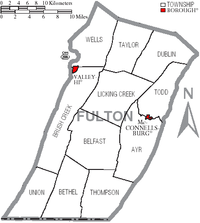
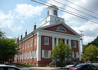
McConnellsburg is a borough and the county seat of Fulton County, Pennsylvania, United States. The population was 1,150 at the 2020 census.

<span class="mw-page-title-main">U.S. Route 522</span> Highway in the United States

U.S. Route 522 is a spur route of US 22 in the states of Virginia, West Virginia, Maryland, and Pennsylvania. The U.S. Highway travels in a north-south direction, and runs 308.59 miles (496.63 km) from US 60 near Powhatan, Virginia, to its northern terminus at US 11 and US 15 near Selinsgrove, Pennsylvania. US 522 serves many small cities and towns in the Piedmont, Blue Ridge Mountains, and northern Shenandoah Valley of Virginia. The highway serves the Virginia communities of Goochland, Mineral, Culpeper, the town of Washington, and Front Royal and the independent city of Winchester. US 522 then follows the Ridge-and-Valley Appalachians north and then east through the Eastern Panhandle of West Virginia, a 2-mile-wide (3.2 km) stretch of Western Maryland, and South Central Pennsylvania to its terminus in the Susquehanna Valley. The highway serves Berkeley Springs, West Virginia; Hancock, Maryland; and the Pennsylvania communities of McConnellsburg, Mount Union, Lewistown, and Middleburg.

<span class="mw-page-title-main">Sideling Hill</span> Mountain ridge in the Appalachian Mountains, U.S.

Sideling Hill, also Side Long Hill, is a long, steep, narrow mountain ridge in the Ridge-and-Valley physiographic province of the Appalachian Mountains, located in Washington County in western Maryland and adjacent West Virginia and Pennsylvania, USA. The highest point on the ridge is Fisher Point, at 2,310 feet (700 m) in Fulton County, Pennsylvania.

<span class="mw-page-title-main">Pennsylvania Route 26</span> State highway in Pennsylvania, US

Pennsylvania Route 26 is a 125.5-mile (202.0 km) highway in the south-central area of Pennsylvania. Its northern terminus is at PA 150 northwest of Howard; its southern terminus is at the Maryland state line near Barnes Gap in Union Township. Two major destinations along this route are Raystown Lake near Huntingdon and the Pennsylvania State University at State College.

<span class="mw-page-title-main">Interstate 70 in Pennsylvania</span> Section of Interstate highway in Pennsylvania, United States

Interstate 70 (I-70) is a state highway that is located in the Commonwealth of Pennsylvania in the United States. It runs east to west across the southwest part of Pennsylvania and serves the southern fringe of the Pittsburgh metropolitan area.

<span class="mw-page-title-main">Pennsylvania Route 16</span> State highway in Pennsylvania, US

Pennsylvania Route 16 is a 43-mile-long (69 km) east–west state route located in southern Pennsylvania, United States. The western terminus of the route is at U.S. Route 522 in McConnellsburg. The eastern terminus is at the Mason–Dixon line in Liberty Township, where the road continues into Maryland as Maryland Route 140. PA 16 is a two-lane road that runs through rural areas in Fulton, Franklin, and Adams counties. The route heads east from McConnellsburg and crosses Tuscarora Mountain into Franklin County, where it continues east into the agricultural Cumberland Valley. Here, the passes through Mercersburg, Greencastle, and Waynesboro. PA 16 heads east through the South Mountain range, where it heads into Adams County and passes through Carroll Valley before coming to the Maryland border. PA 16 intersects several roads including PA 456 in Cove Gap, PA 75 and PA 416 in Mercersburg, PA 995 in Upton, US 11 and Interstate 81 (I-81) in Greencastle, PA 316 and PA 997 in Waynesboro, and PA 116 in Carroll Valley. The road's main name is Buchanan Trail in honor of 15th President James Buchanan, who was born near the road in Cove Gap.

<span class="mw-page-title-main">Town Hill</span>

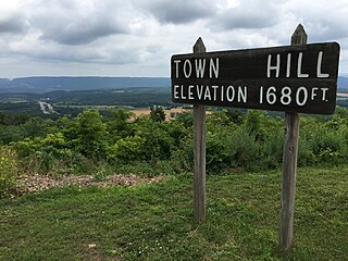
Town Hill is a mountain range that is located in Allegany County, Maryland and Bedford and Fulton counties in Pennsylvania.

<span class="mw-page-title-main">Pennsylvania Route 484</span> State highway in Fulton County, Pennsylvania, US

Pennsylvania Route 484 is a 14.5-mile-long (23.3 km) state highway located in Fulton County in the U.S. state of Pennsylvania. The western terminus is at Pennsylvania Route 26 in Union Township. The eastern terminus is at Pennsylvania Route 655 near Warfordsburg.

<span class="mw-page-title-main">Pennsylvania Route 643</span> State highway in Fulton County, Pennsylvania, US

Pennsylvania Route 643 is a 7.3-mile-long (11.7 km) state highway located in Fulton County, Pennsylvania. The eastern terminus is at U.S. Route 522 in Bethel Township. The western terminus is at Interstate 70 (I-70) in Brush Creek Township.

<span class="mw-page-title-main">Pennsylvania Route 829</span> State highway in Huntingdon County, Pennsylvania, US

Pennsylvania Route 829 is a 17.04-mile-long (27.42 km) state highway located in Huntingdon County, Pennsylvania. The southern terminus is at PA 655 in Cass Township. The northern terminus is at U.S. Route 22 (US 22) in Mill Creek.

<span class="mw-page-title-main">Pennsylvania Route 913</span> State highway in Pennsylvania, US

Pennsylvania Route 913 is a 17.7-mile-long (28.5 km) state highway located in Bedford, Huntingdon, and Fulton counties in Pennsylvania. The western terminus is at PA 26 in Saxton. The eastern terminus is at PA 655 in Taylor Township.

<span class="mw-page-title-main">Pennsylvania Route 915</span> State highway in Pennsylvania, US

Pennsylvania Route 915 is a 22-mile-long (35 km) state highway located in Fulton and Bedford counties in Pennsylvania. The southern terminus is at Interstate 70 (I-70) in Brush Creek Township. The northern terminus is at PA 26 in Hopewell.

<span class="mw-page-title-main">Rays Hill</span>

Rays Hill is a mountain ridge in Pennsylvania's Ridge and Valley Appalachians region. It is bordered to the east by Sideling Hill. About halfway along its run, the west side of Rays Hill ties into Broad Top Mountain, a large plateau.

<span class="mw-page-title-main">Broad Top</span> Plateau in south-central Pennsylvania, United States

Broad Top is a plateau located in south-central Pennsylvania. It extends into Huntingdon County to the north, Fulton County to the southeast, and Bedford County to the southwest. It is bounded to the west by Saxton Mountain and Terrace Mountain, and to the east by Sideling Hill. In Bedford County, Harbor Mountain forms the southern boundary. Trough Creek Valley lies between the mountains.

<span class="mw-page-title-main">Needmore, Pennsylvania</span> Census-designated place in Pennsylvania, United States

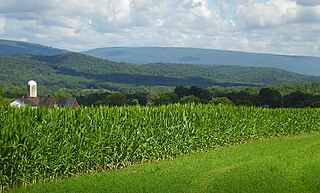
Needmore is an unincorporated community and census-designated place (CDP) in Fulton County, Pennsylvania, United States. As of the 2010 census, the population was 170. Needmore was created on April 27, 1954.

References

  1. Includes Westmoreland, Cambria, Fayette, Blair, Indiana, Somerset, Bedford, Huntingdon, Greene and Fulton Counties
  1. "Census - Geography Profile: Fulton County, Pennsylvania". United States Census Bureau . Retrieved December 18, 2022.
  2. "Find a County". National Association of Counties. Archived from the original on May 31, 2011. Retrieved June 7, 2011.
  3. Fulton County, Pennsylvania Chamber of Commerce and Tourism Website Archived July 5, 2011, at the Wayback Machine
  4. Gannett, Henry (1905). The Origin of Certain Place Names in the United States. Govt. Print. Off. p.  133.
  5. "2010 Census Gazetteer Files". United States Census Bureau. August 22, 2012. Retrieved March 7, 2015.
  6. "PRISM Climate Group at Oregon State University".
  7. "Geology, Map 13". www.dcnr.state.pa.us. Retrieved November 26, 2018.
  8. "Geology, Map 59" (PDF). www.dcnr.state.pa.us. Archived (PDF) from the original on October 9, 2022. Retrieved November 26, 2018.
  9. "Geology, Map 11" (PDF). www.dcnr.state.pa.us. Archived (PDF) from the original on October 9, 2022. Retrieved November 26, 2018.
  10. "Census 2020".
  11. "U.S. Census website". United States Census Bureau . Retrieved January 31, 2008.
  12. "P2 HISPANIC OR LATINO, AND NOT HISPANIC OR LATINO BY RACE – 2020: DEC Redistricting Data (PL 94-171) – Fulton County, Pennsylvania".
  13. 1 2 Leip, David. "Dave Leip's Atlas of U.S. Presidential Elections". uselectionatlas.org. Retrieved November 26, 2018.
  14. Cohn, Nate (April 23, 2014). "Southern Whites' Loyalty to G.O.P. Nearing That of Blacks to Democrats (Map)". The New York Times . Retrieved April 27, 2014.
  15. Pennsylvania Department of State (February 5, 2024). "Voter registration statistics by county". dos.pa.gov. Retrieved February 5, 2024.
  16. 1 2 Center, Legislativate Data Processing. "Find Your Legislator". The official website for the Pennsylvania General Assembly. Retrieved May 11, 2017.
  17. "Penndot Railroad Map January 2015" (PDF). penndot.gov. Archived (PDF) from the original on October 9, 2022. Retrieved December 5, 2016.
  18. "2010 U.S. Census website". United States Census Bureau . Retrieved February 10, 2013.

39°55′N78°07′W / 39.92°N 78.11°W / 39.92; -78.11