Penn Hills, Pennsylvania

Last updated

Penn Hills, Pennsylvania
LongueVueClubandGolfCourse.jpg
Penn Hills logo.png
Motto: 
“A Home Rule Community”
Allegheny County Pennsylvania incorporated and unincorporated areas Penn Hills township highlighted.svg
Location of Allegheny County in Pennsylvania (left) and of Penn Hills in Allegheny County (right)
Coordinates: 40°28′34″N79°50′0″W / 40.47611°N 79.83333°W / 40.47611; -79.83333
CountryUnited States
State Pennsylvania
County Allegheny
Incorporated 1850
Government
  Type Home Rule Municipality
Area
[1]
  Total19.36 sq mi (50.13 km2)
  Land19.12 sq mi (49.52 km2)
  Water0.24 sq mi (0.62 km2)
Population
 (2010)
  Total42,329
  Estimate 
(2018) [2]
40,974
  Density2,173.61/sq mi (839.24/km2)
Time zone UTC−5 (Eastern (EST))
  Summer (DST) UTC−4 (EDT)
ZIP Code
15235
Area code(s) 412, 878
FIPS code 42-003-59032
Website http://www.pennhills.org

Penn Hills is a township with home rule status in Allegheny County, Pennsylvania, United States. The population was 41,059 as of the 2020 census. [3] A suburb of Pittsburgh, Penn Hills is the second-largest municipality in Allegheny County.

Contents

History

In 1788, when Allegheny County was formed, the area now known as Penn Hills was part of Pitt Township. On January 16, 1850, Robert Logan, Thomas Davison and Daniel Bieber were appointed by the court to review the boundaries of a new township to be formed from the northern part of Wilkins. This new township was formed and named Adams, until August 1850 when the action of the court was reconsidered to change the name to McNair Township. The name was again changed to Penn Township by Act of Assembly and approved on February 10, 1851. In 1958 Penn Township became Penn Hills Township, and in 1976 Penn Hills became a home rule municipality. The earliest population was given in 1860, when there were 1,821 people living in Penn Township. The population grew to 2,685 in 1870 and 3,291 in 1880.

Geography

Penn Hills is located at 40°28′34″N79°50′0″W / 40.47611°N 79.83333°W / 40.47611; -79.83333 (40.476218, -79.833302). [4] According to the U.S. Census Bureau, the township has a total area of 19.3 square miles (50 km2), of which 19.0 square miles (49 km2) is land and 0.3 square miles (0.78 km2), or 1.40%, is water. Penn Hills uses the ZIP codes of 15235 and 15147; and the community is within area codes 412 and 878.

Communities

Neighborhoods within Penn Hills include Blackridge, Churchill Valley, Crescent Hills, Eastmont, Eastvue, Laketon Heights, Lincoln Park, Milltown, Nadine, Newfield, North Bessemer, Penn Ridge, Point Breeze, Rosedale, Sandy Creek, Shannon Heights, Universal, Valemont Heights, Gascola, Shadow Shuttle, Frankstown West, Frankstown Estates, Eastwood, and Verona Hilltop.

Streams

Penn Hills is bordered to the north by the Allegheny River. In addition, the waterways listed below flow through the Municipality:

Surrounding communities

Penn Hills has ten land borders, including Verona and Oakmont to the north, Plum Borough to the east and northeast, Monroeville to the southeast, Wilkins Township, Churchill and Wilkinsburg to the south and the Pittsburgh neighborhoods of East Hills to the south, Homewood North to the southwest and Lincoln–Lemington–Belmar to the west.

The Allegheny River borders Penn Hills to the northwest with two neighborhoods running adjacent across the way: O'Hara Township and the borough of Blawnox.

Demographics

Historical population
CensusPop.Note
1860 1,821
1870 2,68547.4%
1880 3,29122.6%
1890 2,932−10.9%
1900 3,40716.2%
1910 6,20782.2%
1920 8,34234.4%
1930 13,33759.9%
1940 15,57816.8%
1950 25,28062.3%
1960 51,512103.8%
1970 62,88622.1%
1980 57,632−8.4%
1990 51,479−10.7%
2000 46,809−9.1%
2010 42,329−9.6%
2020 41,059−3.0%
Sources: [3] [6] [7] [8] [9] [10] [11] [12] [13] [14]

As of the census [3] of 2010, there were 42,329 people living in the township. The population density was 2,268.2 inhabitants per square mile (875.8/km2). There were 20,355 housing units at an average density of 1,069.8 per square mile (413.1/km2). The racial makeup of the township was 60.03% (25,398) White, 37.03% (15,668) African American, 0.98% (409) Asian, 0.01% (4) Pacific Islander, 0.55% from (232) other races. Hispanic or Latino of any race were 1.41% (598) of the population. There is a sizable Italian American population in the township.[ citation needed ]

There were 19,490 households, out of which 26.3% had children under the age of 18 living with them, 51.1% were married couples living together, 13.5% had a female householder with no husband present, and 31.9% were non-families. 28.2% of all households were made up of individuals, and 13.2% had someone living alone who was 65 years of age or older. The average household size was 2.38 and the average family size was 2.91.

In the township the population was spread out, with 21.7% under the age of 18, 6.3% from 18 to 24, 27.0% from 25 to 44, 25.3% from 45 to 64, and 19.7% who were 65 years of age or older. The median age was 42 years. For every 100 females there were 88.6 males. For every 100 females age 18 and over, there were 84.0 males.

The median income for a household in the township was $39,960, and the median income for a family was $46,971. Males had a median income of $36,143 versus $27,331 for females. The per capita income for the township was $20,161. About 5.6% of families and 7.5% of the population were below the poverty line, including 10.8% of those under age 18 and 6.2% of those age 65 or over.

Government and politics

The Penn Hills Government Center is located at 102 Duff Road. This is the home to all municipal offices, including the Penn Hills Police Department and Penn Hills EMS. All public safety divisions are dispatched by Allegheny County 911. [15]

Presidential Elections Results [16] [17] [18]
Year Republican Democratic Third Parties
2020 29% 7,00869% 16,7741% 256
2016 31% 6,76268% 14,9191% 125
2012 32% 7,01768% 14,9900% 199

Government/elected officials

Education

Penn Hills High School Penn Hills Senior High School building Pittsburgh PA 2022-10-22 09-33-48 1.jpg
Penn Hills High School

Penn Hills is served by the Penn Hills School District, which includes: Penn Hills Elementary School, Linton Middle School, and Penn Hills High School.

Transportation

Interstate 376 runs through the southernmost part of Penn Hills, linking it and other eastern suburbs to downtown Pittsburgh.

Pennsylvania Route 791, more commonly referred to as Rodi Road, connects heavily traveled Frankstown Road (at PA-791's northern terminus) with I-376 at its southern terminus. Numerous restaurants, fast food locations, stores, gas stations, and hotels can be found on Rodi, as many truckers and travelers using I-376 use the Penn Hills exit to refuel or stay overnight.

For air travel, Pittsburgh International Airport, located in the western portion of the county, is most commonly used. However, the Allegheny County Airport in West Mifflin is also still in use.

Several bus lines of the Port Authority of Allegheny County offer service to Downtown Pittsburgh, and the Port Authority also has several routes and "flyers" located in Penn Hills.

Major roads

Notable people

See also

Related Research Articles

<span class="mw-page-title-main">Allegheny County, Pennsylvania</span> County in Pennsylvania, United States

Allegheny County is a county in Pennsylvania, United States. As of the 2020 census, the population was 1,250,578, making it the state's second-most populous county, after Philadelphia County. Its county seat and most populous city is Pittsburgh, Pennsylvania's second most populous city. The county is part of the Greater Pittsburgh region of the state, and is the center of the Pittsburgh media market.

<span class="mw-page-title-main">Somerset County, Pennsylvania</span> County in Pennsylvania, United States

Somerset County is a county in the Commonwealth of Pennsylvania. As of the 2020 census, the population was 74,129. Its county seat is Somerset. The county was created from part of Bedford County on April 17, 1795, and named after the county of Somerset in England. The county is part of the Southwest Pennsylvania region of the state.

<span class="mw-page-title-main">Blair County, Pennsylvania</span> County in Pennsylvania, United States

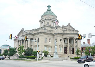
Blair County is a county in the Commonwealth of Pennsylvania. As of the 2020 census, the population was 122,822. Its county seat is Hollidaysburg, and its largest city is Altoona. The county was created on February 26, 1846, from parts of Huntingdon and Bedford counties. The county is part of the Southwest Pennsylvania region of the state.

<span class="mw-page-title-main">Beaver County, Pennsylvania</span> County in Pennsylvania, United States

Beaver County is a county in the Commonwealth of Pennsylvania. As of the 2020 census, the population was 168,215. Its county seat is Beaver, and its largest city is Aliquippa. The county is part of the Greater Pittsburgh region of the state.

<span class="mw-page-title-main">Bethel Park, Pennsylvania</span> Borough in Pennsylvania, United States

Bethel Park is a borough with home rule status in Allegheny County, Pennsylvania, United States. It is a suburb within the Pittsburgh metropolitan area, located approximately 7 miles (11 km) south of Pittsburgh. The population was 33,577 as of the 2020 census.

<span class="mw-page-title-main">Churchill, Pennsylvania</span> Borough in Pennsylvania, United States

Churchill is a borough in Allegheny County, Pennsylvania, United States. The population was 3,157 at the 2020 census. It is a residential suburb of the Pittsburgh metropolitan area. The town was named from the hilltop Beulah Presbyterian Church.

<span class="mw-page-title-main">Jefferson Hills, Pennsylvania</span> Borough in Pennsylvania, United States

Jefferson Hills is a borough in Allegheny County, Pennsylvania, United States. In the 2020 census, the population was 12,424. It is part of the Pittsburgh metropolitan area.

<span class="mw-page-title-main">Monroeville, Pennsylvania</span> Borough in Pennsylvania, United States

Monroeville is a home rule municipality in Allegheny County, Pennsylvania, United States. It is a suburb with mixed residential and commercial developments located about 10 miles (16 km) east of Pittsburgh. As of the 2020 census, Monroeville was home to 28,640 people.

<span class="mw-page-title-main">North Versailles Township, Pennsylvania</span> Township in Pennsylvania, United States

North Versailles is a first class township in Allegheny County, Pennsylvania, United States. The population was 10,079 at the 2020 census. The township derives its name from the Palace of Versailles.

<span class="mw-page-title-main">Oakmont, Pennsylvania</span> Borough in Pennsylvania, United States

Oakmont is a borough in Allegheny County, Pennsylvania, United States, along the Allegheny River. The population was 6,758 as of the 2020 census. It is a suburb of the Pittsburgh metropolitan area.

<span class="mw-page-title-main">Plum, Pennsylvania</span> Borough in Pennsylvania, United States

Plum is a borough in Allegheny County, Pennsylvania, United States. The population was 27,144 at the 2020 census. A suburb of the Pittsburgh metropolitan area, it is located northeast of the city in what is commonly referred to as the East Hills suburbs.

<span class="mw-page-title-main">Verona, Pennsylvania</span> Borough in Pennsylvania, United States

Verona is a borough in Allegheny County, Pennsylvania, United States. It is 13 miles (21 km) northeast of downtown Pittsburgh, along the left bank of the Allegheny River. As of the 2020 census, the borough had a population of 2,492.

<span class="mw-page-title-main">Frankstown Township, Blair County, Pennsylvania</span> Township in Pennsylvania, United States

Frankstown Township is a township in Blair County, Pennsylvania, United States. It is part of the Altoona Metropolitan Statistical Area. The population was 7,399 at the 2020 census. The township was named after Stephen Franks, a pioneer citizen.

<span class="mw-page-title-main">Wilkins Township, Pennsylvania</span> Township in Pennsylvania, United States

Wilkins Township is a township in Allegheny County, Pennsylvania, United States. The population was 6,357 at the 2010 census. It is served by Pennsylvania's 12th congressional district, the 43rd District of the Pennsylvania State Senate, and the 34th District of the Pennsylvania State House of Representatives.

<span class="mw-page-title-main">Interstate 376</span> Highway in Pennsylvania

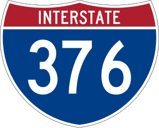
Interstate 376 (I-376) is a major auxiliary route of the Interstate Highway System in the US state of Pennsylvania, located within the Allegheny Plateau. It runs from I-80 near Sharon south and east to a junction with the Pennsylvania Turnpike in Monroeville, after having crossed the Pennsylvania Turnpike at an interchange in Big Beaver. The route serves Pittsburgh and its surrounding areas and is the main access road to Pittsburgh International Airport (PIT). Portions of the route are known as the Beaver Valley Expressway, Southern Expressway, and Airport Parkway. Within Allegheny County, the route runs along the majority of the Penn-Lincoln Parkway, known locally as Parkway West and Parkway East. It is currently the ninth-longest auxiliary Interstate route in the system and second only to I-476 within Pennsylvania.

<span class="mw-page-title-main">Pennsylvania Route 380</span> State highway in Pennsylvania, US

Pennsylvania Route 380, also known as J.F. Bonetto Memorial Highway and within the city of Pittsburgh Bigelow Boulevard, Baum Boulevard and Frankstown Road, is a 32.80-mile-long (52.8 km) state highway in western portions of the U.S. state of Pennsylvania. The western terminus of the route is at Interstate 579 in downtown Pittsburgh near PPG Paints Arena. The eastern terminus is at Pennsylvania Route 286 in Bell Township, near the hamlet of Wakena.

<span class="mw-page-title-main">Pennsylvania Route 130</span> State highway in Pennsylvania, US

Pennsylvania Route 130 (PA 130) is a 49-mile-long (79 km) state highway located in Allegheny and Westmoreland counties in Pennsylvania. The western terminus is at PA 8 in Pittsburgh, and the eastern terminus is at PA 381 near Kregar.

<span class="mw-page-title-main">Pennsylvania Route 791</span> State highway in Allegheny County, Pennsylvania, US

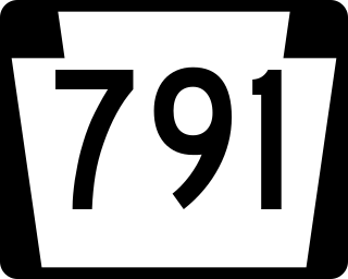
Pennsylvania Route 791 is a state highway located in Penn Hills in Allegheny County, Pennsylvania. It runs 2.10 miles (3.38 km) from U.S. Route 22 Business in Churchill to PA 380 in Penn Hills. The entire route is part of the Yellow Belt of the Allegheny County belt system. The route runs through a suburban area of Pittsburgh.

The 32nd Pennsylvania House of Representatives District is in southwestern Pennsylvania, located entirely in Allegheny County. The district has been represented by Democrat Joe McAndrew since 2023.

Plum Creek is a tributary of the Allegheny River located in Allegheny County in the U.S. state of Pennsylvania. The stream was named for the plum trees lining its banks.

References

  1. "2016 U.S. Gazetteer Files". United States Census Bureau. Retrieved August 13, 2017.
  2. Bureau, U. S. Census. "U.S. Census website". United States Census Bureau . US Census Bureau. Retrieved December 1, 2019.
  3. 1 2 3 "U.S. Census website". United States Census Bureau . Retrieved January 31, 2008.
  4. "US Gazetteer files: 2010, 2000, and 1990". United States Census Bureau. February 12, 2011. Retrieved April 23, 2011.
  5. "Plum Creek". Geographic Names Information System . United States Geological Survey, United States Department of the Interior . Retrieved December 18, 2010.
  6. "Population of Civil Divisions Less than Counties" (PDF). 1870 United States Census. U.S. Census Bureau. Retrieved November 25, 2013.
  7. "Population of Civil Divisions Less than Counties" (PDF). 1880 United States Census. U.S. Census Bureau. Retrieved November 24, 2013.
  8. "Population-Pennsylvania" (PDF). U.S. Census 1910. U.S. Census Bureau. Retrieved November 22, 2013.
  9. "Number and Distribution of Inhabitants:Pennsylvania-Tennessee" (PDF). Fifteenth Census. U.S. Census Bureau.
  10. "Number of Inhabitants: Pennsylvania" (PDF). 18th Census of the United States. U.S. Census Bureau. Retrieved November 22, 2013.
  11. "Pennsylvania: Population and Housing Unit Counts" (PDF). U.S. Census Bureau. Retrieved November 22, 2013.
  12. "Incorporated Places and Minor Civil Divisions Datasets: Subcounty Population Estimates: April 1, 2010 to July 1, 2012". U.S. Census Bureau. Archived from the original on June 11, 2013. Retrieved November 25, 2013.
  13. "Census 2020".
  14. "Race, Hispanic or Latino, Age, and Housing Occupancy: 2010 Census Redistricting Data (Public Law 94-171) Summary File (QT-PL), Penn Hills township, Allegheny County, Pennsylvania". United States Census Bureau . Retrieved September 29, 2011.
  15. Location of municipal building via Google Maps
  16. EL. "2012 Allegheny County election". Pittsburgh Tribune-Review. Retrieved October 15, 2017.
  17. EL. "2016 Pennsylvania general election results". Pittsburgh Post-Gazette. Retrieved October 15, 2017.
  18. "Election Night Reporting".