McKean County, Pennsylvania

Last updated

McKean County
McKean County Courthouse.jpg
McKean County Courthouse
Seal of McKean County, Pennsylvania.png
Map of Pennsylvania highlighting McKean County.svg
Location within the U.S. state of Pennsylvania
Pennsylvania in United States.svg
Pennsylvania's location within the U.S.
Coordinates: 41°48′40″N78°26′41″W / 41.811111111111°N 78.444722222222°W / 41.811111111111; -78.444722222222
CountryFlag of the United States.svg United States
StateFlag of Pennsylvania.svg  Pennsylvania
FoundedSeptember 1, 1826
Named for Thomas McKean
Seat Smethport
Largest city Bradford
Area
  Total984 sq mi (2,550 km2)
  Land979 sq mi (2,540 km2)
  Water5.0 sq mi (13 km2)  0.5%
Population
 (2020)
  Total40,432
  Density41/sq mi (16/km2)
Time zone UTC−5 (Eastern)
  Summer (DST) UTC−4 (EDT)
Congressional district 15th
Website www.mckeancountypa.org

McKean County is a rural county in the Commonwealth of Pennsylvania. As of the 2020 census, the population was 40,432. [1] Its county seat is Smethport. [2] The county was created in 1804 and organized in 1826. [3] It was named in honor of former Pennsylvania Governor and Declaration of Independence signer Thomas McKean. [4] The county is part of the North Central Pennsylvania region of the state. [lower-alpha 1]

Contents

McKean County comprises the Bradford, Pennsylvania micropolitan statistical area. It includes the Allegheny National Forest and borders New York. McKean County boasts of being "The Black Cherry Capital of the World."

McKean County was founded because of its natural resources of oil and timber, both of which continue to provide a significant input to the economy. Today, a university, rural medical center, federal prison and manufacturing companies balance the area's economy.

Geography

According to the U.S. Census Bureau, the county has an area of 984 square miles (2,550 km2), of which 979 square miles (2,540 km2) is land and 5.0 square miles (13 km2) (0.5%) is water. [5] It has a warm-summer humid continental climate (Dfb) and average monthly temperatures in downtown Bradford range from 23.0 °F in January to 67.6 °F in July, while in Mount Jewett they range from 21.2 °F in January to 65.1 °F in July. [6]

Adjacent counties

Major highways

National protected area

Demographics

Historical population
CensusPop.Note
1810 142
1820 728412.7%
1830 1,43997.7%
1840 2,975106.7%
1850 5,25476.6%
1860 8,85968.6%
1870 8,825−0.4%
1880 42,565382.3%
1890 46,86310.1%
1900 51,3439.6%
1910 47,868−6.8%
1920 48,9342.2%
1930 55,16712.7%
1940 56,6732.7%
1950 56,607−0.1%
1960 54,517−3.7%
1970 51,915−4.8%
1980 50,653−2.4%
1990 47,131−7.0%
2000 45,963−2.5%
2010 43,450−5.5%
2020 40,432−6.9%
U.S. Decennial Census [7]
1790–1960 [8] 1900–1990 [9]
1990–2000 [10] 2010–2017 [11] [12]

As of the 2000 census, [13] there were 45,936 people, 18,024 households, and 12,094 families residing in the county. The population density was 47 people per square mile (18 people/km2). There were 21,644 housing units at an average density of 22 units per square mile (8.5/km2). The racial makeup of the county was 96.46% White, 1.87% Black, 0.32% Native American, 0.30% Asian, 0.02% Pacific Islander, 0.40% from other races, and 0.61% from two or more races. 1.06% of the population were Hispanic or Latino of any race. 35.0% German, 22.2% Irish, 14.6% Italian, 12.3% English, 10.0% Swedish, 8.6% American, 5.8% Polish, and 3.7% French ancestry.

There were 18,024 households, out of which 30.50% had children under the age of 18 living with them, 52.50% were married couples living together, 10.10% had a female householder with no husband present, and 32.90% were non-families. 28.30% of all households were made up of individuals, and 13.30% had someone living alone who was 65 years of age or older. The average household size was 2.40 and the average family size was 2.93.

In the county, the age distribution of the population shows 23.70% under the age of 18, 7.90% from 18 to 24, 28.50% from 25 to 44, 23.20% from 45 to 64, and 16.70% who were 65 years of age or older. The median age was 39 years. For every 100 females there were 100.40 males. For every 100 females age 18 and over, there were 98.70 males.

2020 census

McKean County Racial Composition [14]
RaceNum.Perc.
White (NH)36,99191.5%
Black or African American (NH)8492.1%
Native American (NH)1020.3%
Asian (NH)1930.47%
Pacific Islander (NH)20.01%
Other/Mixed (NH)1,6534.1%
Hispanic or Latino 6421.6%

Micropolitan Statistical Area

The United States Office of Management and Budget [15] has designated McKean County as the Bradford, PA micropolitan statistical area (USA). [16] As of the 2010 U.S. Census [17] the micropolitan area ranked 13th most populous in Pennsylvania and the 277th most populous in the United States with a population of 43,450.

Law and government

United States presidential election results for McKean County, Pennsylvania [18]
Year Republican Democratic Third party
No.%No.%No.%
2020 14,08372.18%5,09826.13%3291.69%
2016 11,63570.67%4,02524.45%8044.88%
2012 9,54562.99%5,29734.95%3122.06%
2008 9,22457.61%6,46540.38%3212.00%
2004 10,94162.79%6,29436.12%1911.10%
2000 9,66161.12%5,51034.86%6354.02%
1996 6,83845.99%5,50937.05%2,52216.96%
1992 6,96542.47%5,33132.51%4,10425.02%
1988 9,32363.22%5,30035.94%1240.84%
1984 10,96369.22%4,81830.42%580.37%
1980 9,22960.85%5,06433.39%8735.76%
1976 10,30560.88%6,42437.95%1971.16%
1972 11,95871.72%4,51327.07%2021.21%
1968 10,50659.67%6,32635.93%7754.40%
1964 7,94841.82%10,95057.61%1090.57%
1960 13,69963.62%7,76736.07%660.31%
1956 14,72573.81%5,15225.82%730.37%
1952 15,25673.43%5,37325.86%1470.71%
1948 10,21866.91%4,78531.33%2691.76%
1944 11,98864.45%6,49234.90%1210.65%
1940 14,82267.58%6,99131.88%1190.54%
1936 11,83753.37%9,73343.88%6112.75%
1932 9,97065.01%4,66130.39%7044.59%
1928 14,01273.49%4,96426.04%900.47%
1924 9,07268.99%2,37618.07%1,70112.94%
1920 7,83068.65%2,50521.96%1,0719.39%
1916 4,30051.81%3,16138.09%83810.10%
1912 1,34516.81%2,36229.52%4,29453.67%
1908 5,07358.01%2,86732.78%8059.21%
1904 5,71967.48%1,63619.30%1,12013.22%
1900 6,31961.39%3,42733.29%5475.31%
1896 5,07759.59%3,07436.08%3694.33%
1892 3,59450.01%2,84339.56%75010.44%
1888 4,06652.74%2,92237.90%7219.35%

Voter Registration

As of February 21, 2022, there are 24,893 registered voters in McKean County. [19]

Chart of Voter Registration

   Republican (61.69%)
   Democratic (24.25%)
   Independent (9.22%)
  Third Party (4.83%)

State Senate [20]

State House of Representatives [20]

United States House of Representatives

United States Senate

Education

Map of McKean County, Pennsylvania School Districts Map of McKean County Pennsylvania School Districts.png
Map of McKean County, Pennsylvania School Districts

Public school districts

Private schools

As reported by EdNA, Pennsylvania Department of Education, June 2010.

Libraries

Other education entities

Recreation

There is one Pennsylvania state park in McKean County. Kinzua Bridge State Park is between U.S. Route 6 and Pennsylvania Route 59, just east of the Allegheny National Forest near Mount Jewett. When it was built, it was the highest and longest railroad bridge in the world. It was chosen by the Pennsylvania Department of Conservation and Natural Resources (DCNR) and its Bureau of Parks as one of "Twenty Must-See Pennsylvania State Parks" and is a Historic Civil Engineering Landmark. A tornado destroyed much of the bridge in 2003.

Communities

Map of McKean County, Pennsylvania with Municipal Labels showing Cities and Boroughs (red) and Townships (white). Map of McKean County Pennsylvania With Municipal and Township Labels.png
Map of McKean County, Pennsylvania with Municipal Labels showing Cities and Boroughs (red) and Townships (white).

Under Pennsylvania law, there are four types of incorporated municipalities: cities, boroughs, townships, and, in at most two cases, towns. The following cities, boroughs and townships are located in McKean County:

City

Boroughs

Townships

Census-designated places

Unincorporated communities

Population ranking

The population ranking of the following table is based on the 2010 census of McKean County. [17]

county seat

RankCity/Town/etc.Municipal typePopulation (2010 Census)
1 Bradford City8,770
2 Kane Borough3,730
3 Port Allegany Borough2,157
4 Smethport Borough1,655
5 Foster Brook CDP1,251
6 Mount Jewett Borough919
7 Eldred Borough875
8 Lewis Run Borough617
9 Rew CDP199

See also

Related Research Articles

<span class="mw-page-title-main">Cattaraugus County, New York</span> County in New York, United States

Cattaraugus County is a county in Western New York, with one side bordering Pennsylvania. As of the United States 2020 census, the population was 77,042. The county seat is Little Valley. The county was created in 1808 and later organized in 1817. The county is part of the Western New York region of the state.

<span class="mw-page-title-main">Warren County, Pennsylvania</span> County in Pennsylvania, United States

Warren County is a county in the Commonwealth of Pennsylvania. As of the 2020 census, the population was 38,587. Its county seat is Warren. The county was established in 1800 from parts of Allegheny and Lycoming counties; attached to Crawford County until 1805 and then to Venango County until Warren was formally established in 1819.

<span class="mw-page-title-main">Tioga County, Pennsylvania</span> County in Pennsylvania, United States

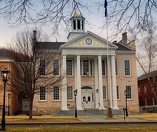
Tioga County is a county in the Commonwealth of Pennsylvania. As of the 2020 census, the population was 41,045. Its county seat is Wellsboro. The county was created on March 26, 1804, from part of Lycoming County and later organized in 1812. It is named for the Tioga River. The county is part of the North Central Pennsylvania region of the state.

<span class="mw-page-title-main">Somerset County, Pennsylvania</span> County in Pennsylvania, United States

Somerset County is a county in the Commonwealth of Pennsylvania. As of the 2020 census, the population was 74,129. Its county seat is Somerset. The county was created from part of Bedford County on April 17, 1795, and named after the county of Somerset in England. The county is part of the Southwest Pennsylvania region of the state.

<span class="mw-page-title-main">Potter County, Pennsylvania</span> County in Pennsylvania, United States

Potter County is a county in the Commonwealth of Pennsylvania. As of the 2020 census, its population was 16,396, making it the fifth-least populous county in Pennsylvania. Its county seat is Coudersport. The county was created in 1804 and later organized in 1836. It is named after James Potter, who was a general from Pennsylvania in the Continental Army during the American Revolution. Due to its remoteness and natural environment, it has been nicknamed “God's Country”.

<span class="mw-page-title-main">Northumberland County, Pennsylvania</span> County in Pennsylvania, United States

Northumberland County is a county in the Commonwealth of Pennsylvania. As of the 2020 census, the population was 91,647. Its county seat is Sunbury. The county is part of the Central Pennsylvania region of the state.

<span class="mw-page-title-main">Lycoming County, Pennsylvania</span> County in Pennsylvania, United States

Lycoming County is a county in the Commonwealth of Pennsylvania. As of the 2020 census, the population was 114,188. Its county seat is Williamsport. The county is part of the Central Pennsylvania region of the state.

<span class="mw-page-title-main">Jefferson County, Pennsylvania</span> County in Pennsylvania, United States

Jefferson County is a county in the Commonwealth of Pennsylvania. As of the 2020 census, the population was 44,492. Its county seat is Brookville. The county was established on March 26, 1804, from part of Lycoming County and later organized in 1830. It is named for President Thomas Jefferson. It is home to Punxsutawney Phil, the most famous groundhog that predicts when spring will come every February 2 on Groundhog Day. The county is part of the North Central Pennsylvania region of the state.

<span class="mw-page-title-main">Forest County, Pennsylvania</span> County in Pennsylvania, United States

Forest County is a county in the Commonwealth of Pennsylvania. As of the 2020 census, the population was 6,973, making it the third-least populous county in Pennsylvania. Its county seat is Tionesta. The county was created in 1848 and later organized in 1857. The county is part of the North Central Pennsylvania region of the state.

<span class="mw-page-title-main">Elk County, Pennsylvania</span> County in Pennsylvania, United States

Elk County is a county in the Commonwealth of Pennsylvania. As of the 2020 United States census, the population was 30,990. Its county seat is Ridgway. The county was created on April 18, 1843, from parts of Jefferson, Clearfield, and McKean Counties. Elk County is named for the eastern elk that historically inhabited the region. The county is part of the North Central Pennsylvania region of the state.

<span class="mw-page-title-main">Clearfield County, Pennsylvania</span> County in Pennsylvania, United States

Clearfield County is a county in the Commonwealth of Pennsylvania. As of the 2020 census, the population was 80,562. The county seat is Clearfield, and the largest city is DuBois. The county was created in 1804 and later organized in 1822.

<span class="mw-page-title-main">Bradford County, Pennsylvania</span> County in Pennsylvania, United States

Bradford County is a county in the Commonwealth of Pennsylvania. As of the 2020 census, its population was 59,967. Its county seat is Towanda. The county was created on February 21, 1810, from parts of Lycoming and Luzerne Counties. Originally called Ontario County, it was reorganized and separated from Lycoming County on October 13, 1812, and renamed Bradford County for William Bradford, who had been a chief justice of the Pennsylvania Supreme Court and United States Attorney General. The county is part of the Northeast Pennsylvania region of the state.

Red House is a town in Cattaraugus County, New York, United States. As of the 2020 census, the town population was 30, making it the least populous town in the state. The town is on the south edge of Cattaraugus County, south of the city of Salamanca.

<span class="mw-page-title-main">Bradford, Pennsylvania</span> City in Pennsylvania, United States

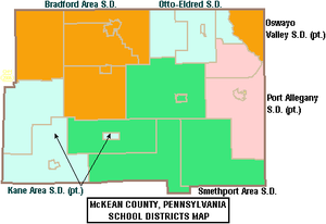
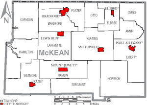
Bradford is a city in McKean County, Pennsylvania. It is located close to the border with New York state and approximately 78 miles (126 km) south of Buffalo, New York. Home to an oil refinery, Zippo headquarters and a University of Pittsburgh branch campus, Bradford is the principal city in the Bradford, PA Micropolitan Statistical Area. The population was 7,825 at the 2020 United States Census.

<span class="mw-page-title-main">Kane, Pennsylvania</span> Borough in Pennsylvania, United States

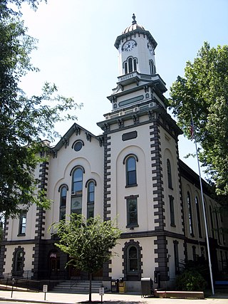
Kane is a borough in McKean County in the U.S. state of Pennsylvania, 94 miles (151 km) east by southeast of Erie. It was founded in 1864 by Civil War General Thomas L. Kane of the famous Bucktail Regiment at an elevated site 2210 feet above sea level. In the early part of the 20th century, Kane had large glass works, bottle works, lumber mills, and manufactures of brush handles, saws, cutlery, screen doors and windows. The population peaked in the 1920s but has since declined to 3,612 people in 2020.

<span class="mw-page-title-main">Mount Jewett, Pennsylvania</span> Borough in Pennsylvania, United States

Mount Jewett is a borough in McKean County, Pennsylvania, United States. The population was 849 at the 2020 census. The students of the borough attend school in the Kane Area School District, even though the borough is surrounded by Hamlin Township—belonging to neighboring Smethport Area School District. Mount Jewett is near to the Kinzua Bridge State Park, which includes the Kinzua Bridge Sky Walk and Kinzua Viaduct. The current mayor is Brianna Howard.

<span class="mw-page-title-main">Smethport, Pennsylvania</span> Borough in Pennsylvania, United States

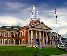
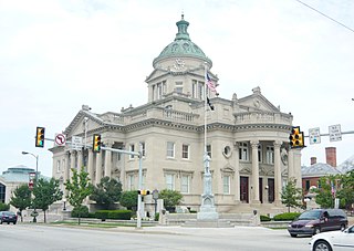
Smethport is a borough in and county seat of McKean County, Pennsylvania, United States. The mayor is Wayne V. Foltz. The population was 1,430 at the 2020 census. Smethport is part of the Bradford, PA Micropolitan Statistical Area. Smethport, having the coldest temperature ever recorded in Pennsylvania, is the coldest place in Pennsylvania and one of the coldest towns in the contiguous United States.

<span class="mw-page-title-main">Portville, New York</span> Town in New York, United States

Portville is a town in Cattaraugus County, New York, United States. The population was 3,504 at the 2020 census. The name is derived from the town's early role in shipping lumber and other items down the Allegheny River. It was formed in 1837 from the town of Olean.

<span class="mw-page-title-main">Pennsylvania Route 59</span> State highway in Pennsylvania, US

Pennsylvania Route 59 is a 39-mile (63 km) long state highway located in northwest Pennsylvania. The route links Warren to Smethport, terminating at U.S. Route 6 at both ends. PA 59 acts as a northerly bypass to US 6, directly connecting Warren and Smethport while US 6 dips south to serve Kane and Mount Jewett.

<span class="mw-page-title-main">Pennsylvania Route 155</span> State highway in Pennsylvania, US

Pennsylvania Route 155 is a 32.2-mile-long (51.8 km) state highway located in Cameron, Potter, and McKean counties in Pennsylvania. The southern terminus is at PA 120 in Emporium. The northern terminus is at PA 446 in Eldred Township.

References

  1. Includes Clearfield, Jefferson, Tioga, McKean, Warren, Clarion, Elk, Potter, Forest and Cameron Counties
  1. "Census - Geography Profile: McKean County, Pennsylvania". United States Census Bureau . Retrieved December 18, 2022.
  2. "Find a County". National Association of Counties. Archived from the original on May 31, 2011. Retrieved June 7, 2011.
  3. "Pennsylvania: Individual County Chronologies". Pennsylvania Atlas of Historical County Boundaries. The Newberry Library. 2008. Archived from the original on March 25, 2015. Retrieved March 13, 2015.
  4. Gannett, Henry (1905). The Origin of Certain Place Names in the United States. U.S. Government Printing Office. p.  194.
  5. "2010 Census Gazetteer Files". United States Census Bureau. August 22, 2012. Retrieved March 9, 2015.
  6. "PRISM Climate Group at Oregon State University". prism.oregonstate.edu.
  7. "U.S. Decennial Census". United States Census Bureau. Retrieved March 9, 2015.
  8. "Historical Census Browser". University of Virginia Library. Retrieved March 9, 2015.
  9. Forstall, Richard L., ed. (March 24, 1995). "Population of Counties by Decennial Census: 1900 to 1990". United States Census Bureau. Retrieved March 9, 2015.
  10. "Census 2000 PHC-T-4. Ranking Tables for Counties: 1990 and 2000" (PDF). United States Census Bureau. April 2, 2001. Archived (PDF) from the original on October 9, 2022. Retrieved March 9, 2015.
  11. "State & County QuickFacts". United States Census Bureau. Archived from the original on June 6, 2011. Retrieved November 20, 2013.
  12. "Census 2020 - McKean County, Pennsylvania". Census.gov . Retrieved April 27, 2024.
  13. "U.S. Census website". United States Census Bureau . Retrieved January 31, 2008.
  14. "P2 HISPANIC OR LATINO, AND NOT HISPANIC OR LATINO BY RACE – 2020: DEC Redistricting Data (PL 94-171) – McKean County, Pennsylvania".
  15. "Office of Management and Budget - The White House" . Retrieved November 27, 2018.
  16. "Businesses that Received Forms in 2012: Pennsylvania - U.S. Census Bureau". Archived from the original on September 24, 2015. Retrieved December 7, 2017.
  17. 1 2 "2010 U.S. Census website". United States Census Bureau . Retrieved February 10, 2013.
  18. Leip, David. "Dave Leip's Atlas of U.S. Presidential Elections". uselectionatlas.org. Retrieved February 21, 2021.
  19. "Voter registration statistics by county". Dos.state.pa.us. Retrieved February 23, 2022.
  20. 1 2 Center, Legislativate Data Processing. "Find Your Legislator". The official website for the Pennsylvania General Assembly. Retrieved May 11, 2017.

41°49′N78°27′W / 41.817°N 78.450°W / 41.817; -78.450