Susquehanna County, Pennsylvania

Last updated

Susquehanna County
Susquehanna County County Seat.jpg
Map of Pennsylvania highlighting Susquehanna County.svg
Location within the U.S. state of Pennsylvania
Pennsylvania in United States.svg
Pennsylvania's location within the U.S.
Coordinates: 41°49′17″N75°48′02″W / 41.82133°N 75.80068°W / 41.82133; -75.80068
CountryFlag of the United States.svg United States
StateFlag of Pennsylvania.svg  Pennsylvania
FoundedOctober 13, 1812
Named for Susquehanna River
Seat Montrose
Largest borough Forest City
Area
  Total832 sq mi (2,150 km2)
  Land823 sq mi (2,130 km2)
  Water8.7 sq mi (23 km2)  1.0%
Population
 (2020)
  Total38,434
  Density46/sq mi (18/km2)
Time zone UTC−5 (Eastern)
  Summer (DST) UTC−4 (EDT)
Congressional district 9th
Website www.susqco.com

Susquehanna County is a county in the Commonwealth of Pennsylvania. As of the 2020 census, the population was 38,434 [1] Its county seat is Montrose. [2] The county was created on February 21, 1810, from part of Luzerne County [3] and later organized in 1812. [4] It is named for the Susquehanna River. The county is part of the Northeast Pennsylvania region of the state. [lower-alpha 1]

Contents

History

Settlement and conflict

The first non-Indigenous settlers began to move into the area from Philadelphia and Connecticut in the mid-1700s. At the time, the area was part of Luzerne County. As more and more people from Connecticut moved in, there began to be some conflict. Connecticut's original land grant gave it control of land within the northern and southern boundaries from present-day Connecticut to the Pacific Ocean. Their land grant overlapped with that of Pennsylvania. Soon fighting began between migrants from each state, resulting in the 1769–1799 Pennamite–Yankee Wars. In the end, the government of Connecticut surrendered its claim on the area.

Formation

In 1810, Susquehanna County was formed out of Luzerne County and later in 1812, Montrose was made the county seat.

Coal and early prosperity

After the Civil War, coal started to be mined. Following this, railways and roads were built into the county allowing for more people to come. At one point the county had nearly 50,000 people. Coal became, as with neighboring counties, the backbone of the economy. This boom in coal would allow for an age of prosperity in the county.

Great Depression

When the Great Depression hit, the coal industry suffered horribly. Within months, the coal industry was struggling. During World War II, the coal industry picked up again, but only for a short time. Soon after, the economy in the county failed. Many mines were closed, railways were torn apart, and the economy took a turn for the worse. Unemployment rose and population decline increased.[ dubious ]

Geography

Milk Can Corners in Hallstead Woman with display at Milk Can Corners, Hallstead, Pennsylvania, 1991.jpg
Milk Can Corners in Hallstead

According to the U.S. Census Bureau, the county has a total area of 832 square miles (2,150 km2), of which 823 square miles (2,130 km2) is land and 8.7 square miles (23 km2) (1.0%) is water. [5]

Susquehanna County is very mountainous, with large concentrations of mountains in the east and smaller, more hill-like mountains in the west. The highest mountain in the county is North Knob just west of Union Dale. Most people live in one of the several long and mostly narrow valleys. These valleys are good farming land.

The county has a warm-summer humid continental climate (Dfb) and average monthly temperatures in Montrose range from 21.2 °F in January to 67.7 °F in July. [6]

Adjacent counties

Demographics

Historical population
CensusPop.Note
1820 9,960
1830 16,78768.5%
1840 21,19526.3%
1850 28,68835.4%
1860 36,26726.4%
1870 37,5233.5%
1880 40,3547.5%
1890 40,093−0.6%
1900 40,043−0.1%
1910 37,746−5.7%
1920 34,763−7.9%
1930 33,806−2.8%
1940 33,8930.3%
1950 31,970−5.7%
1960 33,1373.7%
1970 34,3443.6%
1980 37,87610.3%
1990 40,3806.6%
2000 42,2384.6%
2010 43,3562.6%
2020 38,434−11.4%
U.S. Decennial Census [7]
1790-1960 [8] 1900-1990 [9]
1990-2000 [10] 2010-2017 [1]
Susquehanna Depot Main Street Susquehanna Depot PA.jpg
Susquehanna Depot Main Street

As of the census [11] of 2000, there were 42,238 people, 16,529 households, and 11,785 families residing in the county. The population density was 51 people per square mile (20 people/km2). There were 21,829 housing units at an average density of 26 units per square mile (10/km2). The racial makeup of the county was 98.54% White, 0.30% Black or African American, 0.15% Native American, 0.22% Asian, 0.01% Pacific Islander, 0.17% from other races, and 0.60% from two or more races. 0.67% of the population were Hispanic or Latino of any race. 26% were of English, 16.1% were of German, 15.1% Irish, 8.6% Italian and 7.7% Polish ancestry.

There were 16,529 households, out of which 31.90% had children under the age of 18 living with them, 57.70% were married couples living together, 8.60% had a female householder with no husband present, and 28.70% were non-families. 24.30% of all households were made up of individuals, and 11.50% had someone living alone who was 65 years of age or older. The average household size was 2.53 and the average family size was 2.99.

In the county, the population was spread out, with 25.50% under the age of 18, 6.70% from 18 to 24, 27.10% from 25 to 44, 25.20% from 45 to 64, and 15.50% who were 65 years of age or older. The median age was 40 years. For every 100 females, there were 98.90 males. For every 100 females age 18 and over, there were 95.80 males.

2020 census

Susquehanna County Racial Composition [12]
RaceNum.Perc.
White (NH)35,79993.14%
Black or African American (NH)1380.36%
Native American (NH)590.15%
Asian (NH)1350.35%
Pacific Islander (NH)00%
Other/Mixed (NH)1,4563.8%
Hispanic or Latino 8472.2%

Politics

United States presidential election results for Susquehanna County, Pennsylvania [13] [14]
Year Republican Democratic Third party
No.%No.%No.%
2020 15,20769.72%6,23628.59%3701.70%
2016 12,89167.69%5,12326.90%1,0295.40%
2012 10,80059.62%6,93538.28%3812.10%
2008 10,63354.77%8,38143.17%4012.07%
2004 11,57360.78%7,35138.61%1160.61%
2000 10,22659.21%6,48137.53%5643.27%
1996 7,35447.03%5,91237.81%2,37015.16%
1992 7,35644.02%5,36832.13%3,98523.85%
1988 9,07764.58%4,87134.65%1080.77%
1984 10,56669.95%4,47129.60%670.44%
1980 8,99461.23%4,66031.72%1,0357.05%
1976 8,33156.74%6,07541.38%2761.88%
1972 9,47667.79%4,15429.72%3492.50%
1968 8,70562.04%4,36431.10%9636.86%
1964 6,56745.55%7,83854.37%120.08%
1960 10,20163.88%5,76036.07%90.06%
1956 10,75271.42%4,29328.52%100.07%
1952 10,52973.97%3,65325.66%520.37%
1948 7,94567.81%3,62130.91%1501.28%
1944 8,81967.42%4,21232.20%490.37%
1940 9,52063.71%5,38336.03%390.26%
1936 9,74558.94%6,52039.43%2691.63%
1932 6,88455.99%5,17142.06%2401.95%
1928 9,44568.14%4,35331.40%630.45%
1924 7,26667.38%2,20820.47%1,31012.15%
1920 6,57266.41%2,90529.36%4194.23%
1916 3,89153.08%3,14542.91%2944.01%
1912 1,98826.87%2,58834.98%2,82238.15%
1908 4,99957.30%3,23037.02%4965.68%
1904 4,98861.20%2,57331.57%5897.23%
1900 5,01955.24%3,52738.82%5395.93%
1896 5,31056.73%3,61838.65%4324.62%
1892 4,53153.14%3,38339.67%6137.19%
1888 5,01955.30%3,32836.67%7298.03%

As of January 9, 2023, there are 27,049 registered voters in Susquehanna County. [15]

County commissioners

https://www.susqco.com/departments/county-commissioners

Row offices

State Representatives [17]

State Senators [17]

U.S. Representative

United States Senate

Economy

The economy in the county is mainly made up of retail, health care industry, public school employment, small businesses, and government officials. [18]

Major employers

2018

Listed in order of number of employees at the end of 2018, according to the Pennsylvania Department of Labor and Industry May 2019 monthly report: [19]

2015 [20]
2014 [21]

Natural gas

Since unconventional drilling for natural gas began in 2008, some say the economy has improved. [ citation needed ] According to the U.S. Bureau of Labor Statistics, the unemployment rate in Susquehanna County was 6.1 percent in January 2008. It has since fluctuated between a high of 11.1 percent and a low of 3.1 percent. As of January 2018, the unemployment rate was 5.7 percent. [22] After decades of population growth since the 1950s, the population in Susquehanna County has since begun to decline, concurrent with the expansion of natural gas drilling and accompanying infrastructure. Between 2010 and 2016, there was an estimated population decline of 5.8 percent. As of 2011, there were 1,079 active natural gas wells in the county which had collectively been issued 795 notices of violations by the Department of Environmental Protection of Pennsylvania. [23]

Tourism

Susquehanna County's natural environment, skiing, and small villages make it a growing tourist destination.[ citation needed ]

Education

Map of Susquehanna County, Pennsylvania, school districts Map of Susquehanna County Pennsylvania School Districts.png
Map of Susquehanna County, Pennsylvania, school districts

Public libraries

Public school districts

Vocational schools

Intermediate unit

Northeast Intermediate Unit 19 (NEIU 19)

Private schools

Transportation

Major highways

Rail

Susquehanna County's last mainline passenger train services, through New Milford and Hallstead, ended in January 1970. Since then, freight trains (presently Norfolk Southern) use the railroad line.

Air

Although Susquehanna County boasts several airstrips, they are strictly recreational. The closest main airports are in Binghamton, New York and Scranton, Pennsylvania.

Recreation

There is one Pennsylvania state park in Susquehanna County:

Communities

Map of Susquehanna County with municipalities labeled Susquehanna County, Pennsylvania, Municipalities.png
Map of Susquehanna County with municipalities labeled

Under Pennsylvania law, there are four types of incorporated municipalities: cities, boroughs, townships, and, in two cases at most, towns. The following boroughs and townships are located in Susquehanna County:

Boroughs

Townships

Population ranking

The population ranking of the following table is based on the 2010 census of Susquehanna County. [24]

county seat

RankBorough/TownshipMunicipal typePopulation (2010 Census)
1 Bridgewater Township2,844
2 Clifford Township2,408
3 New Milford Township2,042
4 Great Bend Township1,949
5 Auburn Township1,939
6 Lenox Township1,934
7 Forest City Borough1,911
8 Silver Lake Township1,716
9 Susquehanna Depot Borough1,643
10 Springville Township1,641
11 Montrose Borough1,617
12 Dimock Township1,497
13 Harford Township1,430
14 Hallstead Borough1,303
15 Liberty Township1,292
16 Rush Township1,267
17 Gibson Township1,221
18 Forest Lake Township1,193
19 Brooklyn Township963
20 Franklin Township937
21 New Milford Borough868
22 Jackson Township848
23 Lathrop Township841
24 Great Bend Borough734
25 Choconut Township713
26 Herrick Township713
27 Oakland Borough616
28 Oakland Township564
29 Ararat Township563
30 Jessup Township536
31 Harmony Township528
32 Lanesboro Borough506
33 Apolacon Township500
34 Thompson Township410
35 Middletown Township382
36 Hop Bottom Borough337
37 Thompson Borough299
38 Little Meadows Borough273
39 Union Dale Borough267
40 Friendsville Borough111

See also

Related Research Articles

<span class="mw-page-title-main">Wyoming County, Pennsylvania</span> County in Pennsylvania, United States

Wyoming County is a county in the Commonwealth of Pennsylvania. As of the 2020 census, the population was 26,069. Its county seat is Tunkhannock. It was created in 1842 from part of Luzerne County. The county is part of the Northeast Pennsylvania region of the state.

<span class="mw-page-title-main">Wayne County, Pennsylvania</span> County in Pennsylvania

Wayne is a county in the Commonwealth of Pennsylvania. The county's population was 51,155 at the 2020 census. The county seat is the Borough of Honesdale. The county was formed from part of Northampton County on March 21, 1798, and was named for the Revolutionary War General Anthony Wayne. The county is part of the Northeast Pennsylvania region of the state.

<span class="mw-page-title-main">Sullivan County, Pennsylvania</span> County in Pennsylvania, United States

Sullivan County is a county in the Commonwealth of Pennsylvania. As of the 2020 census, the population was 5,840, making it the second-least populous county in Pennsylvania. Its county seat is Laporte. The county was created on March 15, 1847, from part of Lycoming County and named for Major General John Sullivan. The county is part of the Northeast Pennsylvania region of the state.

<span class="mw-page-title-main">Schuylkill County, Pennsylvania</span> County in Pennsylvania, United States

Schuylkill County is a county in the Commonwealth of Pennsylvania. As of the 2020 census, the population was 143,049. The county seat is Pottsville. The county is part of the Northeast Pennsylvania region of the state.

<span class="mw-page-title-main">Pike County, Pennsylvania</span> County in Pennsylvania, United States

Pike County is a county in the Commonwealth of Pennsylvania. As of the 2020 census, the population was 58,535. Its county seat is Milford. The county is part of the Northeast Pennsylvania region of the state.

<span class="mw-page-title-main">Lycoming County, Pennsylvania</span> County in Pennsylvania, United States

Lycoming County is a county in the Commonwealth of Pennsylvania. As of the 2020 census, the population was 114,188. Its county seat is Williamsport. The county is part of the Central Pennsylvania region of the state.

<span class="mw-page-title-main">Luzerne County, Pennsylvania</span> County in Pennsylvania, United States

Luzerne County is a county in the Commonwealth of Pennsylvania. According to the United States Census Bureau, the county has a total area of 906 square miles (2,350 km2), of which 890 square miles (2,300 km2) is land and 16 square miles (41 km2) is water. It is Northeastern Pennsylvania's second-largest county by total area. As of the 2020 census, the population was 325,594, making it the most populous county in the northeastern part of the state. The county seat and most populous city is Wilkes-Barre. Other populous communities include Hazleton, Kingston, Nanticoke, and Pittston. Luzerne County is included in the Scranton–Wilkes-Barre–Hazleton Metropolitan Statistical Area, which has a total population of 555,426 as of 2017. The county is part of the Northeastern Pennsylvania region of the state.

<span class="mw-page-title-main">Lackawanna County, Pennsylvania</span> County in Pennsylvania, United States

Lackawanna County is a county in the Commonwealth of Pennsylvania. It is located in Northeastern Pennsylvania and had a population of 215,615 (2022). Its county seat and most populous city is Scranton. The county is part of the Northeast Pennsylvania region of the state.

<span class="mw-page-title-main">Columbia County, Pennsylvania</span> County in Pennsylvania, United States

Columbia County is a county in the Commonwealth of Pennsylvania. It is located in Northeastern Pennsylvania. As of the 2020 census, the population was 64,727. Its county seat is Bloomsburg. The county was created on March 22, 1813, from part of Northumberland County. It was named Columbia, alluding to the United States and Christopher Columbus. The county is part of the Central Pennsylvania region of the state.

<span class="mw-page-title-main">Carbon County, Pennsylvania</span> County in Pennsylvania, United States

Carbon County is a county in the Commonwealth of Pennsylvania. As of the 2020 census, the population was 64,749. The county is part of the Northeast Pennsylvania region of the state.

<span class="mw-page-title-main">Pittston Township, Pennsylvania</span> Township in Pennsylvania, United States

Pittston Township is a township in Luzerne County, Pennsylvania. The population was 3,179 as of the 2020 census. The township is located within the Greater Pittston region. As of 2010, the total population of Greater Pittston was 48,020. The Wilkes-Barre/Scranton International Airport is located in Pittston Township.

<span class="mw-page-title-main">Dimock Township, Susquehanna County, Pennsylvania</span> Township in Pennsylvania, United States

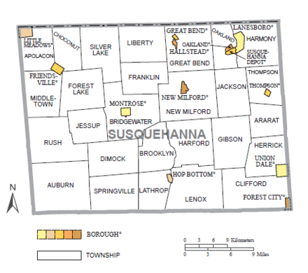
Dimock Township is a township in Susquehanna County, Pennsylvania, United States. The population was 1,232 at the 2020 census. It is the home of former U.S. Congressman Chris Carney, a Democrat who represented Pennsylvania's 10th congressional district from 2007 to 2011. The school building for the Elk Lake School District is located near the village of Elk Lake in the township.

<span class="mw-page-title-main">Great Bend Township, Susquehanna County, Pennsylvania</span> Township in Pennsylvania, United States

Great Bend Township is a township in Susquehanna County, Pennsylvania, United States. The population was 1,711 at the 2020 census. Children living in the township are served by the public schools in the Blue Ridge School District, including Blue Ridge High School.

<span class="mw-page-title-main">Hallstead, Pennsylvania</span> Borough in Pennsylvania, United States

Hallstead is a borough in Susquehanna County, Pennsylvania. The population was 1,179 at the 2020 census.

<span class="mw-page-title-main">Pennsylvania Route 29</span> State highway in Pennsylvania, US

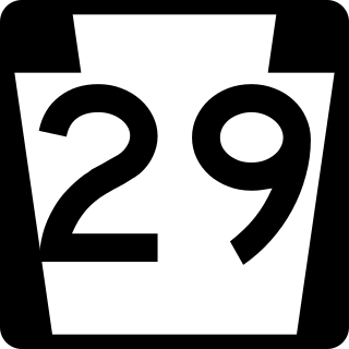
Pennsylvania Route 29 is a 118-mile-long (190 km) north–south state highway that runs through most of eastern Pennsylvania.

<span class="mw-page-title-main">Area codes 570 and 272</span> Northeast Pennsylvania area codes

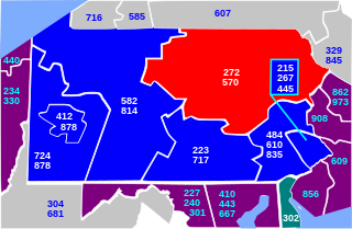
Area codes 570 and 272 are telephone area codes in the North American Numbering Plan (NANP) for the northeast quadrant of the U.S. state of Pennsylvania. The numbering plan area (NPA) includes the cities or towns of Scranton, Wilkes-Barre, Williamsport, Stroudsburg, East Stroudsburg, Pittston, Carbondale, Hazleton, Clarks Summit, Towanda, Bloomsburg, Sayre, Tunkhannock, Berwick, Milford, Montrose, Honesdale, Pocono Pines, Nanticoke, Tamaqua, Shavertown, Dallas, Mahanoy City, Sunbury, Jim Thorpe, and as far south as Pottsville and as far west as Lock Haven.

<span class="mw-page-title-main">Pennsylvania Route 171</span> State highway in Lackawanna and Susquehanna counties in Pennsylvania, United States

Pennsylvania Route 171 is a 40.17-mile-long (64.65 km) north–south state highway located in northeast Pennsylvania. The southern terminus of the route is at U.S. Route 6 Business in Carbondale. The northern terminus is officially at an intersection with US 11, 250 feet (76 m) to the west of Interstate 81 (I-81).

<span class="mw-page-title-main">Pennsylvania Route 374</span> State highway in Susquehanna County, Pennsylvania, US

Pennsylvania Route 374 (PA 374) is a 17.7-mile-long (28.5 km) state highway located in Susquehanna County, Pennsylvania. The western terminus is at PA 92 in the community of Glenwood in Lenox Township. The eastern terminus is at PA 171 and PA 371 in the community of Herrick Center near Union Dale in Herrick Township. The route is a two-lane undivided road that passes through rural areas of farms and woods in southern Susquehanna County. PA 374 intersects PA 407 and Interstate 81 (I-81) in Lenox Township and forms a concurrency with PA 106 in Clifford Township.

<span class="mw-page-title-main">Elk Lake School District</span> School district in Pennsylvania

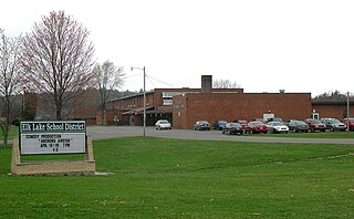
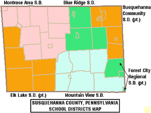
Elk Lake School District is a small, rural, K-12 public school district with its only building located on State Route 3019 in Dimock, Susquehanna County, Pennsylvania. It covers Auburn Township, Middletown Township, Rush Township, Dimock Township, and Springville Township in Susquehanna County, along with Meshoppen Borough and Meshoppen Township in Wyoming County. The Elk Lake School District encompasses approximately 197 square miles (510 km2). According to 2000 federal census data, Elk Lake School District serves a resident population of 7,735 people. In 2009, the district residents’ per capita income was $15,355, while the median family income was $38,385. In the Commonwealth, the median family income was $49,501 and the United States median family income was $49,445, in 2010. In 2006, the district students are 97% white, less than 1% Asian, less than 1% black and 2% Hispanic.

<span class="mw-page-title-main">Montrose Area School District</span> School district in Pennsylvania, U.S.

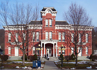
The Montrose Area School District is a small, rural public school district that is located in northwestern Susquehanna County, Pennsylvania. It serves the following municipalities: Montrose, Bridgewater Township, Franklin Township, Liberty Township, Jessup Township, Forest Lake Township, Silver Lake Township, Little Meadows, Choconut Township, Friendsville, and Middletown Township.

References

  1. Includes Luzerne, Lackawanna, Monroe, Schuylkill, Carbon, Pike, Bradford, Wayne, Susquehanna, Wyoming and Sullivan Counties
  1. 1 2 "State & County QuickFacts". United States Census Bureau. Retrieved November 22, 2013.
  2. "Find a County". National Association of Counties. Retrieved June 7, 2011.
  3. "Township Incorporations, 1790 to 1853". Susquehanna County Historical Society. Archived from the original on June 23, 2015. Retrieved March 9, 2013.
  4. "Pennsylvania: Individual County Chronologies". Pennsylvania Atlas of Historical County Boundaries. The Newberry Library. 2008. Archived from the original on March 25, 2015. Retrieved March 13, 2015.
  5. "2010 Census Gazetteer Files". United States Census Bureau. August 22, 2012. Retrieved March 10, 2015.
  6. Parameter-elevation Regressions on Independent Slopes Model
  7. "U.S. Decennial Census". United States Census Bureau. Retrieved March 10, 2015.
  8. "Historical Census Browser". University of Virginia Library. Retrieved March 10, 2015.
  9. Forstall, Richard L., ed. (March 24, 1995). "Population of Counties by Decennial Census: 1900 to 1990". United States Census Bureau. Retrieved March 10, 2015.
  10. "Census 2000 PHC-T-4. Ranking Tables for Counties: 1990 and 2000" (PDF). United States Census Bureau. April 2, 2001. Archived (PDF) from the original on October 9, 2022. Retrieved March 10, 2015.
  11. "U.S. Census website". United States Census Bureau . Retrieved May 14, 2011.
  12. "P2 HISPANIC OR LATINO, AND NOT HISPANIC OR LATINO BY RACE – 2020: DEC Redistricting Data (PL 94-171) – Susquehanna County, Pennsylvania".
  13. Leip, David. "Dave Leip's Atlas of U.S. Presidential Elections". uselectionatlas.org. Retrieved February 21, 2021.
  14. The leading "other" candidate, Progressive Theodore Roosevelt, received 2,498 votes, while Socialist candidate Eugene Debs received 298 votes, Prohibition candidate Eugene Chafin received 25 votes, and Socialist Labor candidate Arthur Reimer received 1 vote.
  15. "Voter registration statistics by county".
  16. Bugda, Jayne Ann (February 5, 2018). "Marion O'Malley Sworn in as Susquehanna County D.A." PAHOMEPAGE. Retrieved November 29, 2018.
  17. 1 2 Center, Legislativate Data Processing. "Find Your Legislator". The official website for the Pennsylvania General Assembly. Retrieved May 12, 2017.
  18. Pennsylvania Department of Community and Economic Development (2015). "Susquehanna County Profile".
  19. Pennsylvania Department of Labor and Industry (May 2019). "Susquehanna County Profile" (PDF).
  20. Pennsylvania Department of Labor and Industry (April 2016). "Susquehanna County Profile" (PDF).
  21. PA Department of Labor and Industries - Center for Workforce Information & Analysis, Susquehanna County Profile 2014, October 2015
  22. U.S. Bureau of Labor Statistics (2018). "Unemployment Rate in Susquehanna County, PA".
  23. NPR State Impact (2018). "Shale Play Susquehanna County Natural Gas Wells Map showing active wells and violations".
  24. Promotions, Center for New Media and. "US Census Bureau 2010 Census". www.census.gov. Retrieved April 3, 2018.

41°49′17″N75°48′02″W / 41.82133°N 75.80068°W / 41.82133; -75.80068