Potter County, Pennsylvania

Last updated

Potter County
Pottercourthousecoudersport.jpg
Flag of Potter County, Pennsylvania.svg
Map of Pennsylvania highlighting Potter County.svg
Location within the U.S. state of Pennsylvania
Pennsylvania in United States.svg
Pennsylvania's location within the U.S.
Coordinates: 41°44′N77°54′W / 41.74°N 77.9°W / 41.74; -77.9
CountryFlag of the United States.svg United States
StateFlag of Pennsylvania.svg  Pennsylvania
FoundedSeptember 1, 1826
Named for James Potter
Seat Coudersport
Largest boroughCoudersport
Area
  Total1,082 sq mi (2,800 km2)
  Land1,081 sq mi (2,800 km2)
  Water0.2 sq mi (0.5 km2)  0.02%
Population
 (2020)
  Total16,396 Decrease2.svg
  Density15/sq mi (6/km2)
Time zone UTC−5 (Eastern)
  Summer (DST) UTC−4 (EDT)
Congressional district 15th
Website visitpottertioga.com

Potter County is a county in the Commonwealth of Pennsylvania. As of the 2020 census, its population was 16,396, [1] making it the fifth-least populous county in Pennsylvania. Its county seat is Coudersport. [2] The county was created in 1804 and later organized in 1836. [3] It is named after James Potter, who was a general from Pennsylvania in the Continental Army during the American Revolution. Due to its remoteness and natural environment, it has been nicknamed “God's Country”. [4] [5] [6] [7] [8] [9]

Contents

The county is part of the North Central Pennsylvania region of the state. [lower-alpha 1]

History

Major Isaac Lyman, an American Revolutionary war veteran was one of the first permanent settlers in Potter County. Major Lyman is recognized as the founder of Potter County. He was paid $10 for each settler he convinced to move to Potter County. He built his home in 1809 in nearby Lymansville, now known as Ladona, just east of Coudersport along Rt. 6. Major Lyman also built the first road to cross Potter County and Potter County's first sawmill and gristmill. [10]

Lyman had a colorful personal history. After the death in childbirth of his first wife, Sally Edgecombe, he remarried; later, he left his second wife and started a third family in Potter County. The second Mrs. Lyman was determined not to suffer on her own. She sought out the major, travelling from Bolton Landing, New York, to Potter County with the help of their son, Burrell, who was 18 at the time. Major Lyman lived with these two families in Potter County. Historical accounts of the living situation vary. Some say that Lyman kept both wives under one roof. Others state that two log homes for the families were on the same piece of property. Descendants of Major Lyman's three families still live and work in Potter County.

Geography

Welcome sign to Potter County Pike Township Enter.jpg
Welcome sign to Potter County

According to the U.S. Census Bureau, the county has a total area of 1,082 square miles (2,800 km2), of which 0.2 square miles (0.52 km2) (0.02%) is covered by water. [11]

Three major watersheds meet, forming a triple divide, in Potter County: Chesapeake Bay, St. Lawrence River, and Mississippi River. Moreover, the main stem by volume of the entire Mississippi river system, the Allegheny River, has its source in central Potter County, near Cobb Hill.

Potter has a warm-summer humid continental climate (Dfb) and average monthly temperatures in Coudersport range from 22.0 °F in January to 66.4 °F in July. [12]

Adjacent counties

Major highways

Demographics

Historical population
CensusPop.Note
1810 29
1820 186541.4%
1830 1,265580.1%
1840 3,371166.5%
1850 6,04879.4%
1860 11,47089.6%
1870 11,265−1.8%
1880 13,79722.5%
1890 22,77865.1%
1900 30,62134.4%
1910 29,729−2.9%
1920 21,089−29.1%
1930 17,489−17.1%
1940 18,2014.1%
1950 16,810−7.6%
1960 16,483−1.9%
1970 16,395−0.5%
1980 17,7268.1%
1990 16,717−5.7%
2000 18,0808.2%
2010 17,457−3.4%
2020 16,396−6.1%
U.S. Decennial Census [13]
1790–1960 [14] 1900–1990 [15]
1990–2000 [16] 2010–2017 [17] 2010-2020 [18]

As of the census [19] of 2000, 18,080 people, 7,005 households, and 5,001 families resided in the county. The population density was 17 people per square mile (6.6 people/km2). The 12,159 housing units had an average density of 11 units per square mile (4.2 units/km2). The racial makeup of the county was 98.06% White, 0.29% African American, 0.22% Native American, 0.50% Asian, 0.22% from other races, and 0.71% from two or more races. About 0.57% of the population were Hispanics or Latinos of any race. By ancestry, 27.3% were of English, 26.9% were of German, 9.9% Irish and 5.8% Italian.

Of the 7,005 households, 31.5% had children under 18 living with them, 59.5% were married couples living together, 7.6% had a female householder with no husband present, and 28.6% were not families. About 24.7% of all households were made up of individuals, and 11.4% had someone living alone who was 65 or older. The average household size was 2.54, and the average family size was 3.02.

In Potter County, the age distribution was 26.0% under 18, 6.9% from 18 to 24, 26.1% from 25 to 44, 24.3% from 45 to 64, and 16.7% who were 65 or older. The median age was 39 years. For every 100 females, there were 97.40 males. For every 100 females 18 and over, there were 94.80 males.

2020 census

Potter County Racial Composition [20]
RaceNum.Perc.
White (NH)15,49494.5%
Black or African American (NH)430.26%
Native American (NH)250.15%
Asian (NH)690.42%
Other/mixed (NH)5183.16%
Hispanic or Latino 2471.5%

Politics and government

United States presidential election results for Potter County, Pennsylvania [21]
Year Republican Democratic Third party
No.%No.%No.%
2020 7,23979.68%1,72619.00%1201.32%
2016 6,25179.49%1,30216.56%3113.95%
2012 5,23171.86%1,89726.06%1512.07%
2008 5,10967.66%2,30030.46%1421.88%
2004 5,64070.84%2,26828.49%540.68%
2000 4,85868.48%2,03728.71%1992.81%
1996 3,71454.48%2,14631.48%95714.04%
1992 3,45249.01%1,89226.86%1,70024.13%
1988 4,43267.23%2,11932.15%410.62%
1984 5,16473.94%1,78925.62%310.44%
1980 4,07361.07%2,29934.47%2974.45%
1976 3,82855.55%2,98343.29%801.16%
1972 4,42270.91%1,71027.42%1041.67%
1968 4,01963.40%1,86029.34%4607.26%
1964 3,23246.78%3,65252.86%250.36%
1960 5,09965.12%2,71534.67%160.20%
1956 5,18169.45%2,25730.25%220.29%
1952 5,11771.78%1,97427.69%380.53%
1948 3,67267.99%1,72932.01%00.00%
1944 4,47469.86%1,89429.58%360.56%
1940 5,20565.36%2,73134.30%270.34%
1936 5,17257.94%3,55339.81%2012.25%
1932 3,84758.53%2,27134.55%4556.92%
1928 5,65379.50%1,41619.91%420.59%
1924 4,08765.49%1,16118.60%99315.91%
1920 4,03670.19%1,10619.23%60810.57%
1916 2,38652.54%1,73338.16%4229.29%
1912 85018.17%1,44530.88%2,38450.95%
1908 3,60360.47%1,93232.43%4237.10%
1904 3,97670.15%1,07418.95%61810.90%
1900 3,22456.29%2,14737.49%3566.22%
1896 3,28155.83%2,44641.62%1502.55%
1892 2,31546.91%1,69934.43%92118.66%
1888 2,57055.68%1,69236.66%3547.67%

Politics and elections

Potter County is one of the most Republican counties in Pennsylvania. In 2004, George W. Bush received 5,640 votes (71%) to 2,268 votes (29%) for John Kerry. The county has voted for the Republican in every presidential election since 1964. In 2006, Rick Santorum received 3,476 votes (63%) to 2,012 votes (37%) for Bob Casey, Jr., making it Santorum's strongest county in his defeat. Lynn Swann also received more than 60% of the Potter County vote in his defeat. In 2016, Donald Trump and Pat Toomey were overwhelmingly elected in Potter County for the U.S. presidential election and U.S. Senate election, respectively. Trump won 80.31% of the vote over Hillary Clinton, while Toomey won 77.79% of the vote over Katie McGinty. In the 2016 state attorney general race, John Rafferty won 79.15% of the vote. [22]

Voter registration

As of February 21, 2022, there are 10,961 registered voters in Potter County. [23]

Chart of Voter Registration

   Republican (69.54%)
   Democratic (19.09%)
   Independent (8.35%)
  Third Party (3.02%)

State Senate [24]

State House of Representatives [24]

United States House of Representatives

United States Senate

Local government

Potter County constitutes Judicial District 55 in the Unified Judicial System of Pennsylvania. [25] The Court of Common Pleas for District 55 is located in Coudersport, and staffed by a single judge, President Judge Stephen P.B. Minor. [26] Since about 2001, Potter County's Court of Common Pleas has become a center for filing no-fault divorces in Pennsylvania, most of which do not involve any Potter County residents. Under Pennsylvania's unusual venue rules, divorce cases involving a Pennsylvania resident may be filed anywhere in the state so long as neither party objects. As of 2009, the over 6,000 divorces filed per year in Potter County raised several hundred thousand dollars in revenue for the county's general fund. [27]

Education

Map of Potter County public school districts Map of Potter County Pennsylvania School Districts.png
Map of Potter County public school districts

Public school districts

Private schools

List from National Center for Education Statistics [28]

Libraries

Pennsylvania EdNA – Educational Entities, 2013

Recreation

Lyman Lake at Lyman Run State Park Fall Preview (1).jpg
Lyman Lake at Lyman Run State Park

Potter County is home to 8 state parks and many more acres of state forest and gamelands.

The county is also the location of the annual "God's Country Marathon" race between Galeton and Coudersport.

Communities

Map of Potter County with municipal labels showing boroughs (red) and townships (white) Map of Potter County Pennsylvania With Municipal and Township Labels.png
Map of Potter County with municipal labels showing boroughs (red) and townships (white)

Under Pennsylvania law, the four types of incorporated municipalities are cities, boroughs, townships, and in at most two cases, towns. These boroughs and townships are located in Potter County:

Boroughs

Townships

Census-designated places

Unincorporated communities

Road district (defunct)

Population ranking

The population ranking of the following table is based on the 2010 census of Potter County. [34]

county seat

RankCity/town/etc.Municipal typePopulation (2010 Census)
1 Coudersport Borough2,546
2 Galeton Borough1,149
3 Shinglehouse Borough1,127
4 Roulette CDP779
5 Ulysses Borough621
6 Austin Borough562
7 Sweden Valley CDP223
8 Oswayo Borough139

See also

Related Research Articles

<span class="mw-page-title-main">Cattaraugus County, New York</span> County in New York, United States

Cattaraugus County is a county in Western New York, with one side bordering Pennsylvania. As of the United States 2020 census, the population was 77,042. The county seat is Little Valley. The county was created in 1808 and later organized in 1817. The county is part of the Western New York region of the state.

<span class="mw-page-title-main">Warren County, Pennsylvania</span> County in Pennsylvania, United States

Warren County is a county in the Commonwealth of Pennsylvania. As of the 2020 census, the population was 38,587. Its county seat is Warren. The county was established in 1800 from parts of Allegheny and Lycoming counties; attached to Crawford County until 1805 and then to Venango County until Warren was formally established in 1819.

<span class="mw-page-title-main">Tioga County, Pennsylvania</span> County in Pennsylvania, United States

Tioga County is a county in the Commonwealth of Pennsylvania. As of the 2020 census, the population was 41,045. Its county seat is Wellsboro. The county was created on March 26, 1804, from part of Lycoming County and later organized in 1812. It is named for the Tioga River. The county is part of the North Central Pennsylvania region of the state.

<span class="mw-page-title-main">Northumberland County, Pennsylvania</span> County in Pennsylvania, United States

Northumberland County is a county in the Commonwealth of Pennsylvania. As of the 2020 census, the population was 91,647. Its county seat is Sunbury. The county is part of the Central Pennsylvania region of the state.

<span class="mw-page-title-main">McKean County, Pennsylvania</span> County in Pennsylvania, United States

McKean County is a rural county in the Commonwealth of Pennsylvania. As of the 2020 census, the population was 40,432. Its county seat is Smethport. The county was created in 1804 and organized in 1826. It was named in honor of former Pennsylvania Governor and Declaration of Independence signer Thomas McKean. The county is part of the North Central Pennsylvania region of the state.

<span class="mw-page-title-main">Lycoming County, Pennsylvania</span> County in Pennsylvania, United States

Lycoming County is a county in the Commonwealth of Pennsylvania. As of the 2020 census, the population was 114,188. Its county seat is Williamsport. The county is part of the Central Pennsylvania region of the state.

<span class="mw-page-title-main">Forest County, Pennsylvania</span> County in Pennsylvania, United States

Forest County is a county in the Commonwealth of Pennsylvania. As of the 2020 census, the population was 6,973, making it the third-least populous county in Pennsylvania. Its county seat is Tionesta. The county was created in 1848 and later organized in 1857. The county is part of the North Central Pennsylvania region of the state.

<span class="mw-page-title-main">Elk County, Pennsylvania</span> County in Pennsylvania, United States

Elk County is a county in the Commonwealth of Pennsylvania. As of the 2020 United States census, the population was 30,990. Its county seat is Ridgway. The county was created on April 18, 1843, from parts of Jefferson, Clearfield, and McKean Counties. Elk County is named for the eastern elk that historically inhabited the region. The county is part of the North Central Pennsylvania region of the state.

<span class="mw-page-title-main">Clearfield County, Pennsylvania</span> County in Pennsylvania, United States

Clearfield County is a county in the Commonwealth of Pennsylvania. As of the 2020 census, the population was 80,562. The county seat is Clearfield, and the largest city is DuBois. The county was created in 1804 and later organized in 1822.

<span class="mw-page-title-main">Clarion County, Pennsylvania</span> County in Pennsylvania, United States

Clarion County is a county in the Commonwealth of Pennsylvania. As of the 2020 census, the population was 37,241. Its county seat is Clarion. The county was formed on March 11, 1839, from parts of Venango and Armstrong counties. Clarion County is entirely defined as part of the Pittsburgh media market. The county is part of the North Central Pennsylvania region of the state.

<span class="mw-page-title-main">Cameron County, Pennsylvania</span> County in Pennsylvania, United States

Cameron County is a county in the Commonwealth of Pennsylvania. As of the 2020 census, the population was 4,547 and is Pennsylvania's least populous county. Its county seat is Emporium. The county was created on March 29, 1860, from parts of Clinton, Elk, McKean, and Potter Counties. It is named for Senator Simon Cameron. The county is part of the North Central Pennsylvania region of the state.

<span class="mw-page-title-main">Bradford County, Pennsylvania</span> County in Pennsylvania, United States

Bradford County is a county in the Commonwealth of Pennsylvania. As of the 2020 census, its population was 59,967. Its county seat is Towanda. The county was created on February 21, 1810, from parts of Lycoming and Luzerne Counties. Originally called Ontario County, it was reorganized and separated from Lycoming County on October 13, 1812, and renamed Bradford County for William Bradford, who had been a chief justice of the Pennsylvania Supreme Court and United States Attorney General. The county is part of the Northeast Pennsylvania region of the state.

<span class="mw-page-title-main">Coudersport, Pennsylvania</span> Borough in Pennsylvania, United States

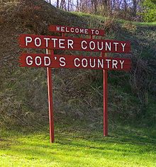
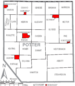
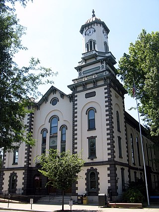
Coudersport is a borough in and the county seat of Potter County, Pennsylvania. It is located approximately 110 miles (180 km) east by south of Erie on the Allegheny River. The population was 2,371 at the 2020 census.

<span class="mw-page-title-main">Sweden Township, Pennsylvania</span> Township in Pennsylvania, United States

Sweden Township is a township in Potter County, Pennsylvania, United States. The population was 871 at the 2020 census.

<span class="mw-page-title-main">Lyman Run State Park</span> State park in Pennsylvania, United States

Lyman Run State Park is a 595-acre (241 ha) Pennsylvania state park in Ulysses and West Branch Townships in Potter County, Pennsylvania in the United States. Lyman Run Lake is a 45-acre (18 ha) man-made lake within the park, surrounded by a northern hardwood forest of mainly maple and cherry trees. Lyman Run State Park is 7 miles (11 km) west of Galeton and 15 miles (24 km) east of Coudersport, and is nearly completely surrounded by the Susquehannock State Forest.

<span class="mw-page-title-main">Denton Hill State Park</span> State park in Potter County, Pennsylvania

Denton Hill State Park is a 700-acre (283 ha) Pennsylvania state park in Ulysses Township, Potter County, Pennsylvania, in the United States. The park is a downhill skiing resort. Denton Hill State Park is on U.S. Route 6 between Coudersport and Galeton. In 2000 the park became part of the Hills Creek State Park complex, an administrative grouping of eight state parks in Potter and Tioga counties.

<span class="mw-page-title-main">Coudersport station</span> United States historic place

The Coudersport and Port Allegany Railroad Station is a railroad station in Coudersport, Pennsylvania, in the United States. It was built by the Coudersport and Port Allegany Railroad in 1899 and opened in January 1900 during the lumber industry boom in Potter County. When the lumber ran out, the railroad's business decreased and in 1964 the line and station were purchased by the Wellsville, Addison and Galeton Railroad. The station was abandoned in 1970 and was unoccupied until 1975, when the borough of Coudersport purchased it. The borough restored it and put a new roof on, then used the building for office space. The station was listed on the National Register of Historic Places on November 21, 1976.

<span class="mw-page-title-main">Coudersport and Port Allegany Railroad</span> Former railroad in Pennsylvania, United States

The Coudersport and Port Allegany Railroad was a shortline railroad that operated in Potter and McKean Counties in Pennsylvania in the United States between 1882 and 1964. The original line ran 17 miles (27 km) along the Allegheny River between the boroughs of Coudersport, the county seat of Potter County, and Port Allegany in McKean County. The line was originally a 3 ft narrow gauge and converted to 4 ft 8+12 instandard gauge in 1889. It was prosperous during a lumber boom in the region and expanded east to Ulysses. The lumber boom ended in the early 20th century and the line slowly declined until 1964, when it was purchased by the Wellsville, Addison and Galeton Railroad. The line was finally abandoned in 1970. Today the only surviving building from the railroad is the Coudersport and Port Allegany Railroad Station, which was listed on the National Register of Historic Places in 1976 and serves as the town hall for Coudersport today. As of 2009, much of the C&PA railroad grading can still be found. Railroad bridge abutments exist at Lillibridge Creek in Port Allegany and along the Allegheny River at Coleman Mills, east of Roulette, and east and west of Coudersport.

<span class="mw-page-title-main">Galeton Area School District</span> School district in Pennsylvania

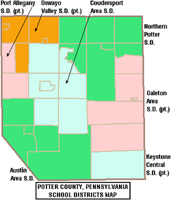
The Galeton Area School District is a diminutive, rural public school district operating in Potter County and Tioga County in Pennsylvania. Galeton Area School District encompasses approximately 325 square miles (840 km2). It serves the municipalities of Galeton, Abbott Township, West Branch Township, Pike Township, and a portion of Hector Township in Potter County, plus Elk Township and Gaines Township in Tioga County, Pennsylvania. According to 2000 federal census data, the district served a resident population of 3,292. By 2010, the district's population declined to 2,929 people. The educational attainment levels for the Galeton Area School District population were 82.7% high school graduates and 9.6% college graduates.

The Potter Leader-Enterprise is an American weekly newspaper serving Coudersport, Pennsylvania, with a circulation of over 6,000 copies. It is published weekly on Wednesdays. The paper is owned by Community Media Group, Inc.

References

  1. Includes Clearfield, Jefferson, Tioga, McKean, Warren, Clarion, Elk, Potter, Forest and Cameron Counties
  1. "Census - Geography Profile: Potter County, Pennsylvania". United States Census Bureau . Retrieved December 18, 2022.
  2. "Find a County". National Association of Counties. Retrieved June 7, 2011.
  3. "Pennsylvania: Individual County Chronologies". Pennsylvania Atlas of Historical County Boundaries. The Newberry Library. 2008. Archived from the original on March 25, 2015. Retrieved March 13, 2015.
  4. Zoe Daniel & Emily Olson (2019). "Nazis, Ku Klux Klan fliers and a dog named Adolf: Is this small US town a hotbed for white nationalism?". ABC News. Retrieved July 18, 2020.
  5. Dennis B. Roddy (2002). "Aryan Nation shares its message of hate". Pittsburgh Post-Gazette. Retrieved July 18, 2020.
  6. "About August Kreis". Southern Poverty Law Center. Retrieved July 18, 2020.
  7. "Aryan Nation seeks revival". Arizona Republic. November 2, 2001.
  8. Alex Davis (2016). "Neo-Nazi group plans event in Potter County". The Bradford Era. Retrieved July 18, 2020.
  9. Susan Koomar (2001). "Former Bangor neo-Nazi setting up camp in Potter County". Pocono Record. Retrieved July 18, 2020.
  10. "Wayback Machine" (PDF). Archived from the original (PDF) on July 4, 2007.
  11. "2010 Census Gazetteer Files". United States Census Bureau. August 22, 2012. Retrieved March 10, 2015.
  12. "PRISM Climate Group at Oregon State University".
  13. "U.S. Decennial Census". United States Census Bureau. Retrieved March 10, 2015.
  14. "Historical Census Browser". University of Virginia Library. Retrieved March 10, 2015.
  15. Forstall, Richard L., ed. (March 24, 1995). "Population of Counties by Decennial Census: 1900 to 1990". United States Census Bureau. Retrieved March 10, 2015.
  16. "Census 2000 PHC-T-4. Ranking Tables for Counties: 1990 and 2000" (PDF). United States Census Bureau. April 2, 2001. Archived (PDF) from the original on October 9, 2022. Retrieved March 10, 2015.
  17. "State & County QuickFacts". United States Census Bureau. Archived from the original on February 24, 2016. Retrieved November 20, 2013.
  18. "Census 2020".
  19. "U.S. Census website". United States Census Bureau . Retrieved January 31, 2008.
  20. "P2 HISPANIC OR LATINO, AND NOT HISPANIC OR LATINO BY RACE – 2020: DEC Redistricting Data (PL 94-171) – Potter County, Pennsylvania".
  21. Leip, David. "Dave Leip's Atlas of U.S. Presidential Elections". uselectionatlas.org. Retrieved March 23, 2018.
  22. "Pennsylvania Elections – County Results". www.electionreturns.pa.gov. Retrieved November 25, 2016.
  23. "Voter registration statistics by county". Dos.state.pa.us. Retrieved February 23, 2022.
  24. 1 2 Center, Legislativate Data Processing. "Find Your Legislator". The official website for the Pennsylvania General Assembly. Retrieved May 11, 2017.
  25. "Judicial Districts". Unified Judicial System of Pennsylvania. Retrieved September 13, 2017.
  26. "Judge's Chambers". Potter County, Pa. Retrieved September 13, 2017.
  27. ""Untying the knot" in Potter, Cameron Counties". EndeavorNews. June 20, 2009. Archived from the original on September 13, 2017.
  28. ies, National Center for Education Statistics, US Department of Education, Institute of Education Sciences, Private School Universe Survey 2008
  29. "Coudersport Public Library". Archived from the original on January 12, 2014.
  30. "Galeton Public Library".
  31. "Genesee Area Library | More Than Just Books!". Archived from the original on January 11, 2014.
  32. "Oswayo Valley Memorial Library". Archived from the original on January 11, 2014.
  33. "Ulysses Public Library".
  34. Promotions, Center for New Media and. "US Census Bureau 2010 Census". www.census.gov. Retrieved March 23, 2018.

41°44′N77°54′W / 41.74°N 77.90°W / 41.74; -77.90